 Old Cumbria Gazetteer
 |
 |
|
|
| Whitehaven and Furness Junction Railway | |||
| Cumbrian Coast Line | |||
| civil parish:- | Whitehaven (formerly Cumberland) | ||
| civil parish:- | St Bees (formerly Cumberland) | ||
| civil parish:- | Lowside Quarter (formerly Cumberland) | ||
| civil parish:- | St Bridget Beckermet (formerly Cumberland) | ||
| civil parish:- | Ponsonby (formerly Cumberland) | ||
| civil parish:- | Seascale (formerly Cumberland) | ||
| civil parish:- | Drigg and Carleton (formerly Cumberland) | ||
| civil parish:- | Muncaster (formerly Cumberland) | ||
| civil parish:- | Waberthwaite (formerly Cumberland) | ||
| civil parish:- | Bootle (formerly Cumberland) | ||
| civil parish:- | Whicham (formerly Cumberland) | ||
| civil parish:- | Millom Without (formerly Cumberland) | ||
| civil parish:- | Broughton West (formerly Lancashire) | ||
| county:- | Cumbria | ||
| locality type:- | railway | ||
| SummaryText:- | from Whitehaven, through Corkickle, St Bees, Nethertown, Braystones, Sellafield, Seascale, Drigg, Ravenglass, Eskmeals, Bootle, Silecroft, Millom, Green Road, Cumberland; to Foxfield on the Furness Railway, Lancashire, 1849. Extension from Corkickle to join the Whitehaven Junction Railway, 1852. | ||
| references:- | 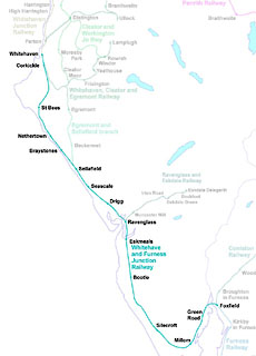 click to enlarge click to enlargeRWY014.jpg |
||
|
|
|||
 BLW36.jpg (taken 18.4.2006) |
|||
|
|
|||
| evidence:- | old map:- Garnett 1850s-60s H |
||
| source data:- | Map of the English Lakes, in Cumberland, Westmorland and
Lancashire, scale about 3.5 miles to 1 inch, published by John
Garnett, Windermere, Westmorland, 1850s-60s.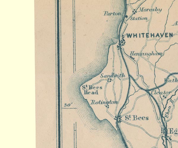 GAR2NX91.jpg triple line, light bold light, railway 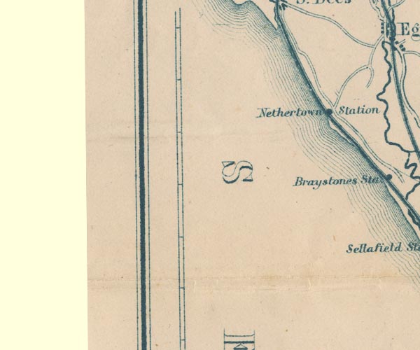 GAR2NX90.jpg 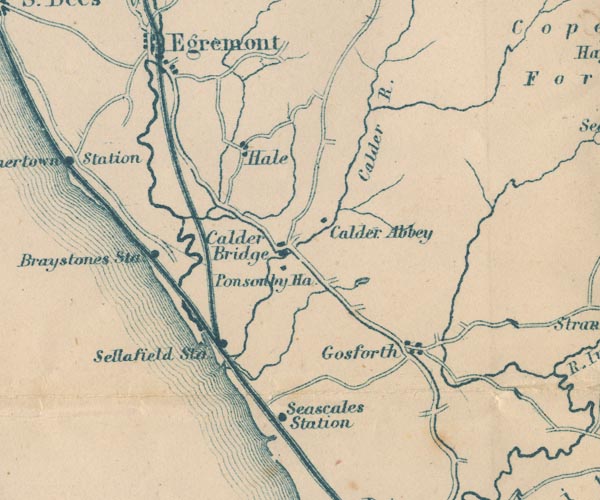 GAR2NY00.jpg 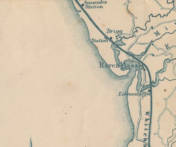 GAR2SD09.jpg  GAR2SD19.jpg 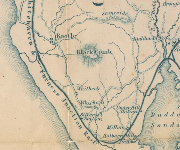 GAR2SD18.jpg "Whitehaven &Furness Junction Raily." 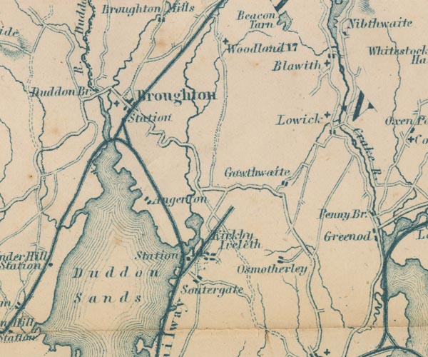 GAR2SD28.jpg item:- JandMN : 82.1 Image © see bottom of page |
||
|
|
|||
| evidence:- | old map:- LMS 1939 B |
||
| source data:- | 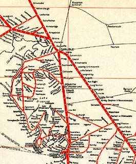 click to enlarge click to enlargeLMS6Cm.jpg "MAP OF LMS RAILWAY" item:- JandMN : 1016.5 Image © see bottom of page |
||
|
|
|||
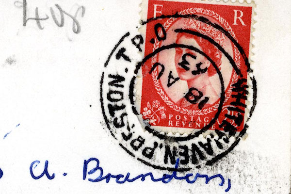 CCS55.jpg Postmark:- "WHITEHAVEN PRESTON T.P.O / 18 AU / 63" for a Travelling Post Office. Stamp - Elizabeth II, 2½pence, red |
|||
| This TPO ran between Whitehaven and Preston in the 1930s-760s. |
|||
|
|
|||
| evidence:- | old print:- item:- rail |
||
| source data:- | Print, uncoloured engraving, Saint Bees, Cumberland, drawn by R Shepherd, published
1850s-60s.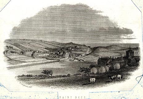 click to enlarge click to enlargePR0572.jpg Notice the Whitehaven and Furness Junction Railway. printed at bottom:- "SAINT BEES" item:- Dove Cottage : 2008.107.520 Image © see bottom of page |
||
|
|
|||
| hearsay:- |
33¾miles. |
||
| An early plan went from Millom Station, across the 1¼mile Duddon estuary by viaduct,
to join the Furness railway south of Kirkby. |
|||
| New powers were acquired, 1865, for a line from Millom across the Duddon estuary to
a junction with the Furness Railway at Askam, and then straight across to Lindal.
This never hapenned; the FR took over in 1865. A contractor had started work on the
new viaduct, materials onsite, etc by 1867. |
|||
|
|
|||
| person:- | railway company : Whitehaven and Furness Junction Railway |
||
| date:- | 1845 to 1865 |
||
|
|
|||
| person:- | railway company : Furness Railway; FR |
||
| date:- | 1865 to 1923 |
||
|
|
|||
| person:- | railway company : London, Midland and Scottish Railway; LMS |
||
| date:- | 1923 to 1948 |
||
|
|
|||
| person:- | railway company : British Railways; BR |
||
| date:- | 1948 |
||
|
|
|||
| goes through:- |  Preston Street Goods, Whitehaven engine shed, Whitehaven (2) Corkickle No.2 Junction, Whitehaven railway junction, Corkickle Mirehouse Junction, Whitehaven level crossing, St Bees St Bees Station, St Bees Nethertown Station, Lowside Quarter railway bridge, Nethertown Braystones Station, Lowside Quarter Sellafield Junction, St Bridget Beckermet Sellafield Station, St Bridget Beckermet Preston Street Goods, Whitehaven engine shed, Whitehaven (2) Corkickle No.2 Junction, Whitehaven railway junction, Corkickle Mirehouse Junction, Whitehaven level crossing, St Bees St Bees Station, St Bees Nethertown Station, Lowside Quarter railway bridge, Nethertown Braystones Station, Lowside Quarter Sellafield Junction, St Bridget Beckermet Sellafield Station, St Bridget Beckermet[Sellafield Sidings, St Bridget Beckermet] Calder Viaduct, St Bridget Beckermet railway bridge, Seascale Seascale Station, Seascale railway bridge, Seascale (2) railway bridge, Whitriggs coal depot, Drigg Drigg Station, Drigg Irt Viaduct, Drigg and Carleton railway bridge, Drigg and Carleton level crossing, Saltcoats railway viaduct, Ravenglass railway bridge, Ravenglass Ravenglass Station, Ravenglass Walls Bridge, Ravenglass Eskmeals Viaduct, Waberthwaite Eskmeals Station, Bootle railway bridge, Bootle[Eskmeals Range siding, Bootle] railway bridge, Bootle (3) railway bridge, Bootle (2) Bootle Station, Hycemoor Whitbeck Crossing, Whitbeck railway bridge, Whitbeck Silecroft Station, Millom Without level crossing, Millom Without accommodation crossing, Kirksanton lineside hut, Kirksanton Kirksanton Crossing, Kirksanton railway bridge, Millom (2) accommodation crossing, Millom Haverigg Crossing, Millom signal box, Millom railway bridge, Millom Millom Station, Millom railway footbridge, Millom railway milepost, Millom Millom Junction, Millom level crossing, Millom Without (2) level crossing, Underhill Underhill Station, Millom Without Green Road Station, Millom Without railway bridge, Green Road Duddon Viaduct, Broughton West level crossing, Foxfield engine shed, Foxfield Foxfield Junction, Broughton West21.7.1845: incorporated - 1849 - 1850: opened |
||
|
|
|||
| goes through:- | Corkickle No.2 Junction, Whitehaven Corkickle Station, Whitehaven Whitehaven Tunnel, Whitehaven Whitehaven Station, Whitehaven Bransty Junction, Whitehaven 1855: opened, passengers - |
||
|
|
|||
Lakes Guides menu.