 Old Cumbria Gazetteer
 |
 |
|
| Irt Viaduct, Drigg and Carleton | ||
| Irt Viaduct | ||
| site name:- | Whitehaven and Furness Junction Railway | |
| site name:- | Irt, River | |
| civil parish:- | Drigg and Carleton (formerly Cumberland) | |
| county:- | Cumbria | |
| locality type:- | railway viaduct | |
| locality type:- | viaduct | |
| coordinates:- | SD06789852 | |
| 1Km square:- | SD0698 | |
| 10Km square:- | SD09 | |
|
|
||
| evidence:- | outline view:- Linton 1852 placename:- Irt Viaduct |
|
| source data:- | Print, engraving, outline views, Mountains as Seen from the Esk Viaduct, the Eskmeals
Viaduct, and Mountains as Seen from the Viaduct near Drigg, the Irt Viaduct, Whitehaven
and Furness Junction Railway, Cumberland, engraved by W H Lizars, Edinburgh, published
by Whittaker and Co, London, and by R Gibson and Son and by Callander and Dixon, Whitehaven,
Cumberland, 1852.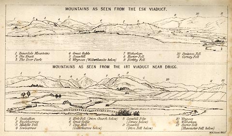 click to enlarge click to enlargeLN1E13.jpg Tipped in opposite p.86 of A Handbook of the Whitehaven and Furness Railway, by John Linton. printed at upper scene, top:- "MOUNTAINS AS SEEN FROM THE ESK VIADUCT." printed at upper scene caption:- "1 Ennerdale Mountains 2 The Knott 3 The Deer Park 4 Great Gable 5 Scawfell 6 Wrynose (Waberthwaite below) 7 Wetherlam 8 Harter Fell 9 Birkby Fell 10 Stainton Fell 11 Corney Fell" printed at lower scene, top:- "MOUNTAINS AS SEEN FROM THE IRT VIADUCT NEAR DRIGG." printed at lower scene caption:- "1 Seatallan 2 Buckbarrow 3 Middle Fell 4 Yewbarrow 5 Kirk Fell (Irton Church below) 6 Great Gable 7 Ling Mell (Latterbarrow below) 8 Scawfell Pike (Screes below) 9 Scawfell (Irton Fell below) 10 Wrynose 11 Wetherlam 12 Harter Fell (Muncaster Fell below)" printed at bottom right:- "W. H. Lizars Edinr." item:- Armitt Library : A1158.11 Image © see bottom of page |
|
|
|
||
 Lakes Guides menu.