 Garnett 1850s-60s NY31


|

|
|
|
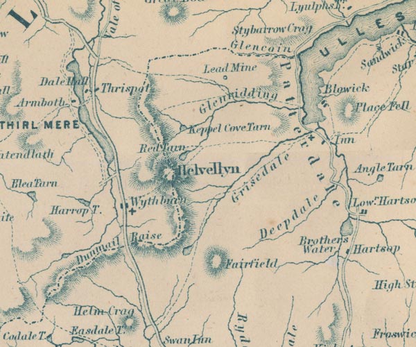
gazetteer links places may or may not be labelled on the map |
||

|
-- Armboth House -- "Armboth" |
|
|
|
-- Blowick -- "Blowick" |
|
|
|
-- Brothers Water -- "Brothers Water" |
|
|
|
-- Dalehead Hall -- "Dale Hall" |
|
|
|
-- Deepdale -- "Deepdale" |
|
|
|
-- Dunmail Raise -- "Dunmail Raise" |
|
|
|
-- Fairfield -- "Fairfield" |
|
|
|
-- Glencoyne Beck |
|
|
|
-- Glencoyne -- "Glencoin" |
|
|
|
-- Glenridding Beck |
|
|
|
-- Greenside Lead Mine -- "Lead Mine" |
|
|
|
-- Grisedale Beck |
|
|
|
-- Grisedale -- "Grisedale" |
|
|
|
-- Harrop Tarn -- "Harrop T." |
|
|
|
-- Helvellyn -- "Helvellyn" |
|
|
|
-- Keppelcove Tarn -- "Keppel Cove Tarn" |
|
|
|
-- Patterdale Hotel -- "Inn" |
|
|
|
-- Patterdale -- "Patterdale" |
|
|
|
-- Red Tarn -- "Red Tarn" |
|
|
|
-- Ambleside to Keswick |
|
|
|
-- St Patrick's Church |
|
|
|
-- Thirlmere -- "THIRL MERE" |
|
|
|
-- Thirlspot -- "Thirlspot" |
|
|
|
-- Ullswater -- "ULLES WATER" |
|
|
|
-- Wyth Burn |
|
|
|
-- Wythburn Chapel |
|
|
|
-- Wythburn -- "Wythburn" |
|
|
civil parishes The area roughly includes parts of parishes:- Lakes Matterdale Martindale St John's Castlerigg and Wythburn Patterdale |
||
|
|
||
|
|
Lakes Guides menu. | |