 Old Cumbria Gazetteer
 |
 |
|
||||||||||||||||||||||||
| Thirlmere | ||||||||||||||||||||||||||
| runs into:- |  St John's Beck St John's Beck |
|||||||||||||||||||||||||
|
|
||||||||||||||||||||||||||
| Thirlmere Reservoir | ||||||||||||||||||||||||||
| Leathes Water | ||||||||||||||||||||||||||
| Wythburn Water | ||||||||||||||||||||||||||
| civil parish:- | St John's Castlerigg and Wythburn (formerly Cumberland) | |||||||||||||||||||||||||
| county:- | Cumbria | |||||||||||||||||||||||||
| locality type:- | lake | |||||||||||||||||||||||||
| locality type:- | reservoir | |||||||||||||||||||||||||
| coordinates:- | NY32031423 (etc etc) | |||||||||||||||||||||||||
| 1Km square:- | NY3214 | |||||||||||||||||||||||||
| 10Km square:- | NY31 | |||||||||||||||||||||||||
|
|
||||||||||||||||||||||||||
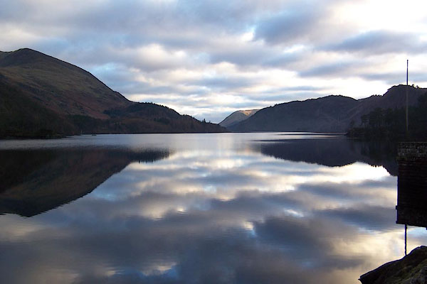 BLM58.jpg Looking south. (taken 25.12.2005) 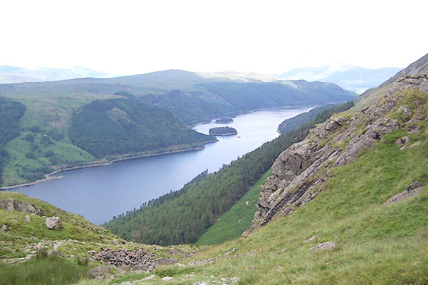 BRB42.jpg From Helvellyn. (taken 9.7.2009) |
||||||||||||||||||||||||||
|
|
||||||||||||||||||||||||||
| evidence:- | old map:- OS County Series (Cmd 70 4) placename:- Thirlmere |
|||||||||||||||||||||||||
| source data:- | Maps, County Series maps of Great Britain, scales 6 and 25
inches to 1 mile, published by the Ordnance Survey, Southampton,
Hampshire, from about 1863 to 1948. OS County Series (Cmd 70 8) |
|||||||||||||||||||||||||
|
|
||||||||||||||||||||||||||
| evidence:- | old map:- OS County Series (Cmd 70) |
|||||||||||||||||||||||||
| source data:- | Maps, County Series maps of Great Britain, scales 6 and 25
inches to 1 mile, published by the Ordnance Survey, Southampton,
Hampshire, from about 1863 to 1948. "Sur.of Water 5[33].2" |
|||||||||||||||||||||||||
|
|
||||||||||||||||||||||||||
| evidence:- | old map:- Saxton 1579 placename:- Thurle Myer Flu. |
|||||||||||||||||||||||||
| source data:- | Map, hand coloured engraving, Westmorlandiae et Cumberlandiae Comitatus ie Westmorland
and Cumberland, scale about 5 miles to 1 inch, by Christopher Saxton, London, engraved
by Augustinus Ryther, 1576, published 1579-1645. Sax9NY21.jpg "Thurle myer flu" Lake. item:- private collection : 2 Image © see bottom of page |
|||||||||||||||||||||||||
|
|
||||||||||||||||||||||||||
| evidence:- | old map:- Mercator 1595 (edn?) placename:- |
|||||||||||||||||||||||||
| source data:- | Map, hand coloured engraving, Northumbria, Cumberlandia, et
Dunelmensis Episcopatus, ie Northumberland, Cumberland and
Durham etc, scale about 6.5 miles to 1 inch, by Gerard Mercator,
Duisberg, Germany, about 1595. MER8CumF.jpg "" outline, coast shaded, tinted blue; lake item:- JandMN : 169 Image © see bottom of page |
|||||||||||||||||||||||||
|
|
||||||||||||||||||||||||||
| evidence:- | old map:- Speed 1611 (Cmd) |
|||||||||||||||||||||||||
| source data:- | Map, hand coloured engraving, Cumberland and the Ancient Citie
Carlile Described, scale about 4 miles to 1 inch, by John Speed,
1610, published by J Sudbury and George Humble, Popes Head
Alley, London, 1611-12.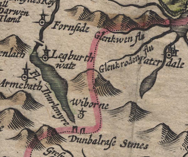 SP11NY31.jpg outline, shaded item:- private collection : 16 Image © see bottom of page |
|||||||||||||||||||||||||
|
|
||||||||||||||||||||||||||
| evidence:- | poem:- Drayton 1612/1622 text placename:- Thurls Mere |
|||||||||||||||||||||||||
| source data:- | Poem, Poly Olbion, by Michael Drayton, published by published by
John Marriott, John Grismand and Thomas Dewe, and others?
London, part 1 1612, part 2 1622. goto source page 165:- "... Thurls mighty Mere, ..." |
|||||||||||||||||||||||||
|
|
||||||||||||||||||||||||||
| evidence:- | old map:- Drayton 1612/1622 placename:- Thurle Mere |
|||||||||||||||||||||||||
| source data:- | Map, hand coloured engraving, Cumberlande and Westmorlande, by
Michael Drayton, probably engraved by William Hole, scale about
4 or 5 miles to 1 inch, published by John Mariott, John
Grismand, and Thomas Dewe, London, 1622. DRY514.jpg "Thurle mere" Lake, naiaid. item:- JandMN : 168 Image © see bottom of page |
|||||||||||||||||||||||||
|
|
||||||||||||||||||||||||||
| evidence:- | probably old map:- Jenner 1643 |
|||||||||||||||||||||||||
| source data:- | Tables of distances with a maps, Westmerland, scale about 16
miles to 1 inch, and Cumberland, scale about 21 miles to 1 inch,
published by Thomas Jenner, London, 1643; published 1643-80. JEN4Sq.jpg outline, shaded |
|||||||||||||||||||||||||
|
|
||||||||||||||||||||||||||
| evidence:- | old map:- Jansson 1646 placename:- Thurlemyre Flud |
|||||||||||||||||||||||||
| source data:- | Map, hand coloured engraving, Cumbria and Westmoria, ie
Cumberland and Westmorland, scale about 3.5 miles to 1 inch, by
John Jansson, Amsterdam, Netherlands, 1646.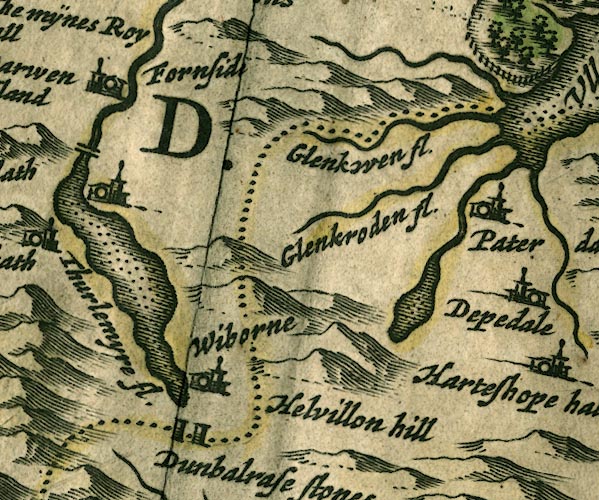 JAN3NY31.jpg "Thurlemyre fl." Outline with shore shaded, dotted area. item:- JandMN : 88 Image © see bottom of page |
|||||||||||||||||||||||||
|
|
||||||||||||||||||||||||||
| evidence:- | old map:- Ogilby 1675 (plate 96) placename:- Wibourn Water |
|||||||||||||||||||||||||
| source data:- | Road strip map, hand coloured engraving, the Road from Kendal to
Cockermouth, and the Road from Egremond to Carlisle, scale about
1 inch to 1 mile, by John Ogilby, London, 1675. OG96m020.jpg In miles 22 and 23, Cumberland. "Wibourn Water" lake close on the left of the road for a mile and a half. item:- JandMN : 22 Image © see bottom of page |
|||||||||||||||||||||||||
|
|
||||||||||||||||||||||||||
| evidence:- | old map:- Sanson 1679 |
|||||||||||||||||||||||||
| source data:- | Map, hand coloured engraving, Ancien Royaume de Northumberland
aujourdhuy Provinces de Nort, ie the Ancient Kingdom of
Northumberland or the Northern Provinces, scale about 9.5 miles
to 1 inch, by Nicholas Sanson, Paris, France, 1679. click to enlarge click to enlargeSAN2Cm.jpg outline, shore shaded; lake item:- Dove Cottage : 2007.38.15 Image © see bottom of page |
|||||||||||||||||||||||||
|
|
||||||||||||||||||||||||||
| evidence:- | old map:- Seller 1694 (Cmd) |
|||||||||||||||||||||||||
| source data:- | Map, uncoloured engraving, Cumberland, scale about 12 miles to 1
inch, by John Seller, 1694. click to enlarge click to enlargeSEL9.jpg outline with shaded shore; lake item:- Dove Cottage : 2007.38.89 Image © see bottom of page |
|||||||||||||||||||||||||
|
|
||||||||||||||||||||||||||
| evidence:- | old map:- Morden 1695 (Cmd) placename:- Thurlemyre River |
|||||||||||||||||||||||||
| source data:- | Map, uncoloured engraving, Cumberland, scale about 4 miles to 1
inch, by Robert Morden, 1695, published by Abel Swale, the
Unicorn, St Paul's Churchyard, Awnsham, and John Churchill, the
Black Swan, Paternoster Row, London, 1695-1715.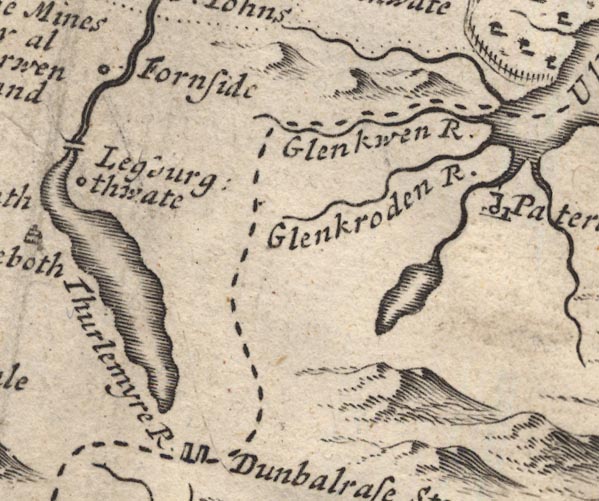 MD12NY31.jpg "Thurlemyre R" Outline with shore shading. item:- JandMN : 90 Image © see bottom of page |
|||||||||||||||||||||||||
|
|
||||||||||||||||||||||||||
| evidence:- | old map:- Morden 1695 (Wmd) |
|||||||||||||||||||||||||
| source data:- | Map, hand coloured engraving, Westmorland, scale about 2.5 miles to 1 inch, by Robert
Morden, published by Abel Swale, the Unicorn, St Paul's Churchyard, Awnsham, and John
Churchill, the Black Swan, Paternoster Row, London, 1695.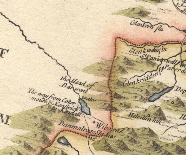 MD10NY31.jpg Outline, blue tint. item:- JandMN : 24 Image © see bottom of page |
|||||||||||||||||||||||||
|
|
||||||||||||||||||||||||||
| evidence:- | old map:- Bowen 1720 (plate 260) placename:- Wibourn Water |
|||||||||||||||||||||||||
| source data:- | Road strip map, uncoloured engraving, pl.260, The Road from
Kendal to Cockermouth, scale about 2 miles to 1 inch, with
sections in Westmorland and Cumberland, published by Emanuel
Bowen, St Katherines, London, 1720. B260m20.jpg At mile 22-23. item:- private collection : 1.260 Image © see bottom of page |
|||||||||||||||||||||||||
|
|
||||||||||||||||||||||||||
| evidence:- | old map:- Badeslade 1742 placename:- |
|||||||||||||||||||||||||
| source data:- | Map, uncoloured engraving, A Map of Cumberland North from
London, scale about 11 miles to 1 inch, with descriptive text,
by Thomas Badeslade, London, engraved and published by William
Henry Toms, Union Court, Holborn, London, 1742. click to enlarge click to enlargeBD10.jpg "" outline with form lines item:- JandMN : 115 Image © see bottom of page |
|||||||||||||||||||||||||
|
|
||||||||||||||||||||||||||
| evidence:- | old map:- Simpson 1746 map (Wmd) |
|||||||||||||||||||||||||
| source data:- | Map, uncoloured engraving, Westmorland, scale about 8 miles to 1
inch, printed by R Walker, Fleet Lane, London, 1746. SMP2NYF.jpg Outline with form lines. item:- Dove Cottage : 2007.38.59 Image © see bottom of page |
|||||||||||||||||||||||||
|
|
||||||||||||||||||||||||||
| evidence:- | old map:- Bowen and Kitchin 1760 placename:- Wiborn Water |
|||||||||||||||||||||||||
| source data:- | Map, hand coloured engraving, A New Map of the Counties of
Cumberland and Westmoreland Divided into their Respective Wards,
scale about 4 miles to 1 inch, by Emanuel Bowen and Thomas
Kitchin et al, published by T Bowles, Robert Sayer, and John
Bowles, London, 1760.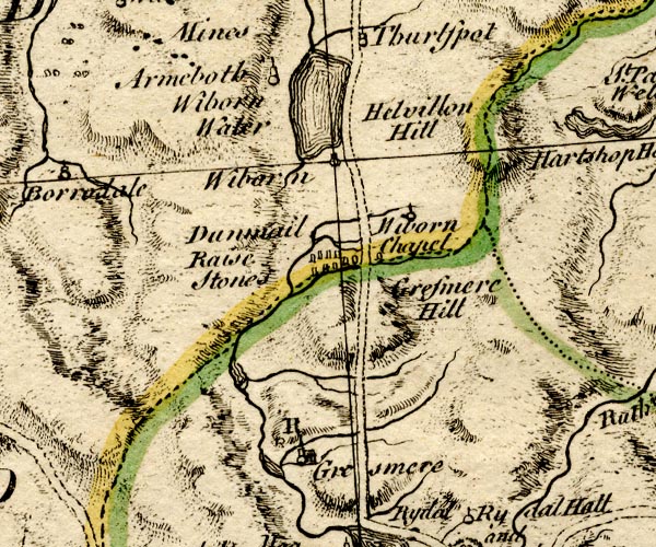 BO18NY20.jpg "Wiborn Water" outline with form lines item:- Armitt Library : 2008.14.10 Image © see bottom of page |
|||||||||||||||||||||||||
|
|
||||||||||||||||||||||||||
| evidence:- | old map:- Donald 1774 (Cmd) placename:- Thurle Meer |
|||||||||||||||||||||||||
| source data:- | Map, hand coloured engraving, 3x2 sheets, The County of Cumberland, scale about 1
inch to 1 mile, by Thomas Donald, engraved and published by Joseph Hodskinson, 29
Arundel Street, Strand, London, 1774. D4NY31NW.jpg  D4NY31SW.jpg "Thurle Meer" lake item:- Carlisle Library : Map 2 Images © Carlisle Library |
|||||||||||||||||||||||||
|
|
||||||||||||||||||||||||||
| evidence:- | descriptive text:- West 1778 (11th edn 1821) placename:- Leathes Water placename:- Wythburn placename:- Wythburn Water placename:- Thirlemere placename:- Thirlmere |
|||||||||||||||||||||||||
| source data:- | Guide book, A Guide to the Lakes, by Thomas West, published by
William Pennington, Kendal, Cumbria once Westmorland, and in
London, 1778 to 1821. goto source Page 83:- "... Leaving the vale of Grasmere behind, you soon come in sight of" "LEATHES-WATER," "Called also WYTHBURN or THIRLEMERE. It begins at the foot of Helvellyn, and skirts its base for the space of four miles, encreased by a variety of pastoral torrents, that pour their silvery streams down the mountains' sides, and then, warbling, join the lake. The range of mountains, on the right [at Leathes Water], are tre-" goto sourcePage 84:- "[tre]mendously great. Helvellyn and Cachidecam are the chief; ... The opposite shore is beautified with a variety of crown-topt rocks, some rent, some wooded, others not, rising immediately from, or hanging towards the water; and all set off with a back ground of verdant mountains, rising in the noblest pastoral style. Its singular beauty is its being almost intersected in the middle by two peninsulas, that are joined by a bridge, in a taste suitable to the genius of the place, which serves for an easy communication among the shepherds that dwell on the opposite banks." "..." goto sourcePage 190:- "A TABLE OF THE Height of Mountains and Lakes SEEN IN THIS TOUR, ... TAKEN FROM THE LEVEL OF THE SEA. ... by Mr. John Dalton." "Leathes-water, Wythburn ... 182 [yards]" goto sourceAddendum; Mr Gray's Journal, 1769 Page 210:- "..." "Oct. 8. I left Keswick, and took the Ambleside road, ... Came to the foot of Helvellyn, along which runs an excellent road, looking down from a little height on Leathes-water, (called also Thirlmere, or Wythburn-water) and soon descending on its margin. The lake looks black from its depth, and from the gloom of the vast crags that scowl over it, though really clear as glass: it is narrow, and about three miles long, resembling a river in its course; little shining torrents hurrying down the rocks to join it, but not a bush to overshadow them or cover their march; ..." |
|||||||||||||||||||||||||
|
|
||||||||||||||||||||||||||
| evidence:- | old map:- West 1784 map placename:- Leathes Water |
|||||||||||||||||||||||||
| source data:- | Map, hand coloured engraving, A Map of the Lakes in Cumberland,
Westmorland and Lancashire, scale about 3.5 miles to 1 inch,
engraved by Paas, 53 Holborn, London, about 1784.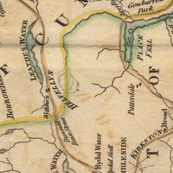 Ws02NY31.jpg "LEATHES WATER" item:- Armitt Library : A1221.1 Image © see bottom of page |
|||||||||||||||||||||||||
|
|
||||||||||||||||||||||||||
| evidence:- | old text:- Clarke 1787 placename:- Thyrillmere item:- fish, Thirlmere; pike; trout |
|||||||||||||||||||||||||
| source data:- | Guide book, A Survey of the Lakes of Cumberland, Westmorland,
and Lancashire, written and published by James Clarke, Penrith,
Cumberland, and in London etc, 1787; published 1787-93. goto source Page 117:- "..." "Thyrillmere belongs to Thomas Leathes, Esq; but is of small value for fish; there are none indeed found here but a few pike and trout. The form of it much resembles that of a bee or pismire, as it is so narrow in the middle, that there is a bridge across it; at each end it swells out to a considerable extent, as may be seen in the plan. The mountain which bounds one side of the lake is Helveylin, as far as Swirls-gate; on the other (from Armboth to Wythburn,) is called the Deer-garth." |
|||||||||||||||||||||||||
|
|
||||||||||||||||||||||||||
| evidence:- | old map:- Clarke 1787 map (Ambleside to Keswick) placename:- Thirlmere Lake |
|||||||||||||||||||||||||
| source data:- | Map, A Map of the Roads Lakes etc between Keswick and Ambleside,
scale about 2.5 ins to 1 mile, by James Clarke, engraved by S J
Neele, 352 Strand, published by James Clarke, Penrith,
Cumberland and in London etc, 1787.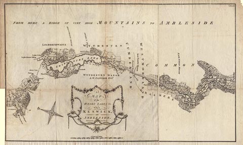 click to enlarge click to enlargeCL09.jpg "THIRLMERE LAKE" item:- private collection : 10.9 Image © see bottom of page |
|||||||||||||||||||||||||
|
|
||||||||||||||||||||||||||
| evidence:- | old map:- Clarke 1787 map (Ambleside to Keswick) placename:- Thirlmere Lake |
|||||||||||||||||||||||||
| source data:- | Map, A Map of the Roads Lakes etc between Keswick and Ambleside,
scale about 2.5 ins to 1 mile, by James Clarke, engraved by S J
Neele, 352 Strand, published by James Clarke, Penrith,
Cumberland and in London etc, 1787.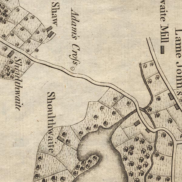 CL9NY31E.jpg 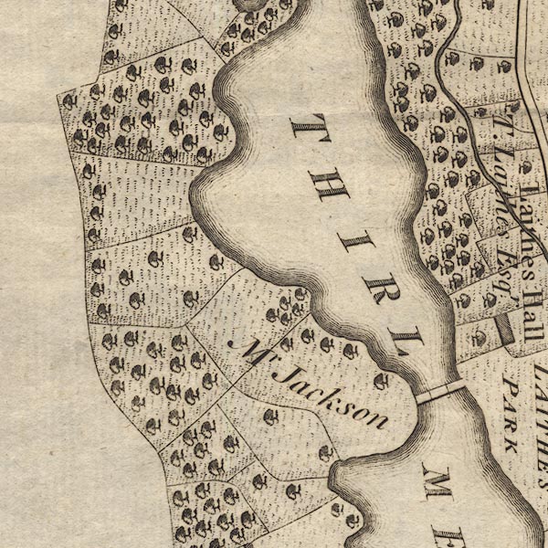 CL9NY31D.jpg 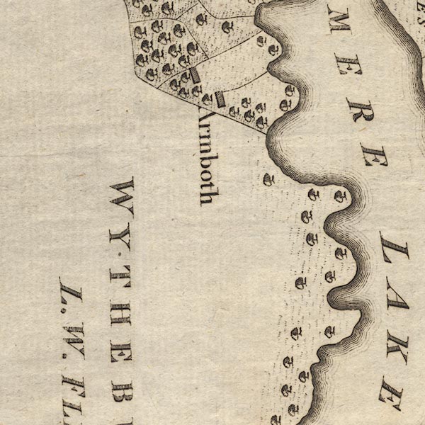 CL9NY31C.jpg 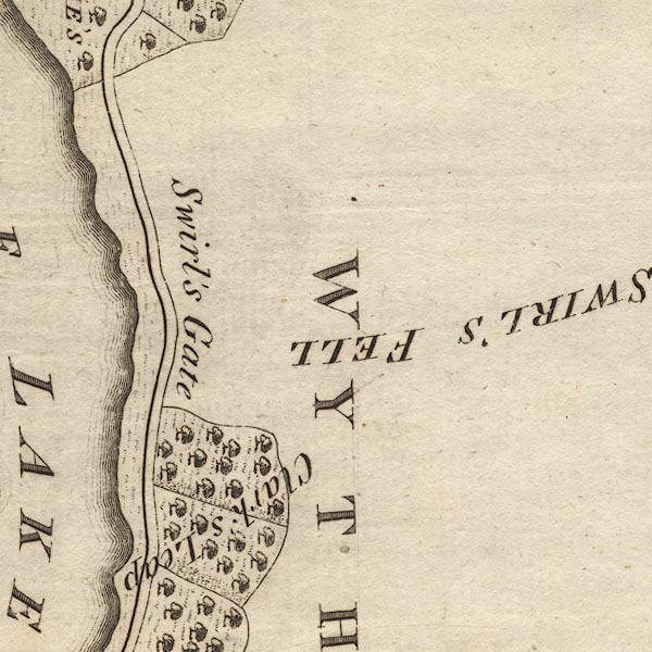 CL9NY31H.jpg  CL9NY31B.jpg  CL9NY31G.jpg "THIRLMERE LAKE" item:- private collection : 10.9 Image © see bottom of page |
|||||||||||||||||||||||||
|
|
||||||||||||||||||||||||||
| evidence:- | probably old text:- Camden 1789 (Gough Additions) placename:- Brackmere item:- fish, Thirlmere; pike; perch; eels |
|||||||||||||||||||||||||
| source data:- | Book, Britannia, or A Chorographical Description of the Flourishing Kingdoms of England,
Scotland, and Ireland, by William Camden, 1586, translated from the 1607 Latin edition
by Richard Gough, published London, 1789. goto source Page 181:- "..." "At the foot of Wythburn fells is Brackmere, a large lake, a mile by one and an half, well stocked with pike, perch, and eels. ..." |
|||||||||||||||||||||||||
|
|
||||||||||||||||||||||||||
| evidence:- | old painting:- Green 1790s-1820s (1802) item:- clouds |
|||||||||||||||||||||||||
| source data:- | Painting, watercolour, Thirlmere, Wythburn, St John's Castlerigg and Wythburn, Cumberland,
by William Green, Ambleside, Westmorland, 1802.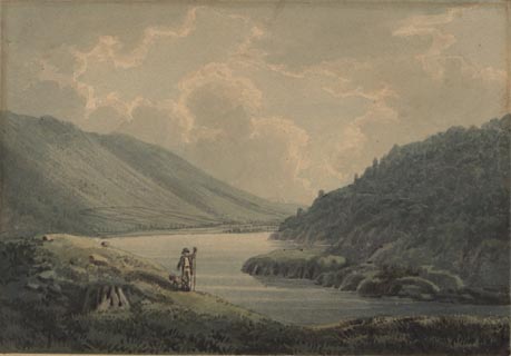 click to enlarge click to enlargePR1733.jpg item:- Dove Cottage : 1991.73.1 Image © see bottom of page |
|||||||||||||||||||||||||
|
|
||||||||||||||||||||||||||
| evidence:- | old print:- Smith 1795 placename:- Thirlmere |
|||||||||||||||||||||||||
| source data:- | Print uncoloured engraving, with some aquatint, Wyburn Lake, at the Lower End, Thirlmere,
Cumberland, drawn by John 'Warwick' Smith, engraved by F Merigot, published by R Blamire,
Strand, London, 1791. click to enlarge click to enlargePR1851.jpg printed, bottom left, right, centre "Drawn by John Smith. / Engrav'd by F. Merigot. / WYBURN LAKE, / at the Lower End. / Published as the Act directs, March, 1791, by Rd. Blamire, Strand, London." item:- Armitt Library : 2011.66 Image © see bottom of page |
|||||||||||||||||||||||||
|
|
||||||||||||||||||||||||||
| evidence:- | old map:- Housman 1800 map 3 placename:- Thurlemeer |
|||||||||||||||||||||||||
| source data:- | Maps, hand coloured engraving, Lakes in Cumberland, 9 lakes on one sheet, engraved
by James Lowes, published by F Jollie, Carlisle, Cumberland, and C Law, Ave Maria
Lane, London, 1800. click to enlarge click to enlargeHM01Thi.jpg "THURLEMEER" item:- Dove Cottage : 2007.38.96 Image © see bottom of page |
|||||||||||||||||||||||||
|
|
||||||||||||||||||||||||||
| evidence:- | old map:- Cooke 1802 placename:- Leaths Water |
|||||||||||||||||||||||||
| source data:- | Map, The Lakes, Westmorland and Cumberland, scale about 8.5
miles to 1 inch, engravedby Neele and Son, published by
Sherwood, Jones and Co, Paternoster Road, London, 1824. click to enlarge click to enlargeGRA1Lk.jpg "Leaths W." outline with form lines; lake or tarn item:- Hampshire Museums : FA2000.62.5 Image © see bottom of page |
|||||||||||||||||||||||||
|
|
||||||||||||||||||||||||||
| evidence:- | old map:- Cooke 1802 placename:- Thurle Meer |
|||||||||||||||||||||||||
| source data:- | Map, Cumberland, scale about 15.5 miles to 1 inch, by George
Cooke, 1802, bound in Gray's New Book of Roads, 1824, published
by Sherwood, Jones and Co, Paternoster Road, London, 1824. click to enlarge click to enlargeGRA1Cd.jpg "Thurle Meer" outline with form lines; lake or tarn item:- Hampshire Museums : FA2000.62.2 Image © see bottom of page |
|||||||||||||||||||||||||
|
|
||||||||||||||||||||||||||
| evidence:- | old print:- Green 1804 (plate 10) placename:- Leathes Water placename:- Thirlmere placename:- Wyburn Water |
|||||||||||||||||||||||||
| source data:- | Print, uncoloured aquatint, Leathes Water, Thirlmere, or Wyburn Water, St John's Castlerigg
and Wythburn, Cumberland, by William Green, Ambleside, Westmorland, 1804.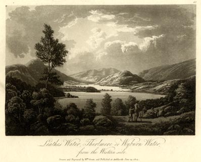 click to enlarge click to enlargeGN1610.jpg Plate 10 from a series. printed at bottom:- "Leathes Water, Thirlmere, or Wyburn Water, / from the Western side. / Drawn and Engraved by Wm. Green, and Published at Ambleside, June 24, 1804." printed at top right:- "10" at :- "W ELGAR / 1802" item:- Armitt Library : 2014.153 Image © see bottom of page |
|||||||||||||||||||||||||
|
|
||||||||||||||||||||||||||
| evidence:- | old text:- Gents Mag placename:- Leathes Water |
|||||||||||||||||||||||||
| source data:- | Magazine, The Gentleman's Magazine or Monthly Intelligencer or
Historical Chronicle, published by Edward Cave under the
pseudonym Sylvanus Urban, and by other publishers, London,
monthly from 1731 to 1922. goto source Gentleman's Magazine 1805 p.1011 "... Leathes-water is a picturesque expanse in the bosom of the valley. The surrounding mountains fling a deep shade over the surface of the water, and a narrow peninsula jutting from the margin, affords an easy intercourse to the shepherds of the opposite border. The Western edge swells into a little promontory, decorated with a neat manor-house shrouded in trees. But the objects of greatest beauty are a group of Rocks, which raise the closing screen of the landscape. These wear a variety of figure and ornament; some of them are pyramidal, and dressed in green wood to the very summit; other magnificently turreted, project boldly, as if to display their naked sides of silver grey. In the back ground are seen the broad gloomy ridges of Saddleback and Threlkeld Fells, hung with a pall of the deepest sable. ..." |
|||||||||||||||||||||||||
|
|
||||||||||||||||||||||||||
| evidence:- | old map:- Laurie and Whittle 1806 placename:- Thirles Mere |
|||||||||||||||||||||||||
| source data:- | Road map, Completion of the Roads to the Lakes, scale about 10
miles to 1 inch, by Nathaniel Coltman? 1806, published by Robert
H Laurie, 53 Fleet Street, London, 1834. click to enlarge click to enlargeLw18.jpg "Thirles Mere" lake, in two pieces item:- private collection : 18.18 Image © see bottom of page |
|||||||||||||||||||||||||
|
|
||||||||||||||||||||||||||
| evidence:- | old text:- Capper 1808 placename:- Leath Water placename:- Withburn Water |
|||||||||||||||||||||||||
| source data:- | Gazetteer, A Topographical Dictionary of the United Kingdom,
compiled by Benjamin Pitts Capper, published by Richard
Phillips, Bridge Street, Blackfriars, London, 1808; published
1808-29. goto source "..." "LEATH WATER or WITHBURN, a fine lake in Cumberland, lying south-east of Keswick. It commences at the foot of mount Kellwellyn, which it skirts for 4 miles, and in that distance receives numerous torrents which descend from the mountains. It is almost intersected in the middle by 2 peninsulas which are joined by a neat bridge of timber. The outlet of this lake unites with the rapid river Greeta at New-bridge. It has a communication with Derwent water. - Tour to the Lakes." "..." |
|||||||||||||||||||||||||
|
|
||||||||||||||||||||||||||
| evidence:- | old map:- Cooper 1808 placename:- Thirle Mere |
|||||||||||||||||||||||||
| source data:- | Map, uncoloured engraving, Cumberland, scale about 10.5 miles to
1 inch, drawn and engraved by Cooper, published by R Phillips,
Bridge Street, Blackfriars, London, 1808. click to enlarge click to enlargeCOP3.jpg "Thirle Mere" outline, shaded; lake item:- JandMN : 86 Image © see bottom of page |
|||||||||||||||||||||||||
|
|
||||||||||||||||||||||||||
| evidence:- | old text:- Green 1810 placename:- Wyburn Water placename:- Thril Mere placename:- Leath's Water |
|||||||||||||||||||||||||
| source data:- | Set of prints, soft ground etchings, Sixty Studies from Nature,
by William Green, Ambleside, Westmorland, drawn 1808-10,
published 1810. goto source page 52:- "..." "Wyburn Water, Thril Mere, or Leath's Water, has its latter name from the family of Leath, who have long resided at Dalehead, a venerable edifice on the banks of the lake." "..." goto sourcepage 54:- "..." "The beauties of Wyburn Water are all seen from the western side. Mrs. Radcliffe, like others who have written upon it, seems not to have deviated from the turnpike road, for she says, "This is a long but narrow and un-" page 55:- "[un]adorned lake, having little else than walls or rocky fells starting from its margin." - It is to be regretted that Mrs. Radcliffe did not traverse the other side, for had she done so, the public would doubtless have been much gratified by her elegant description of the scene before her." "Wyburn Water may be visited from Ambleside or Keswick, or from the inn at Wyburn, which is not a mile from the head of the lake; but those who would avail themselves of all its beauties, must go round it." "The western side of the lake is to be travelled only on foot or on horse-back, the roads being sometiimes steep, but oftener rugged: the road from Keswick over the bridges which cut the lake in two, is about thirteen miles; that round the head of the lake about sixteen. - From Ambleside round the foot of the lake is upwards of twenty-" goto sourcepage 56:- "[twenty-]four miles, but over the bridges about twenty." "Between the head of the lake and Armbath, the property and residence of Mr. Jackson, is a fine view of the upper and lower waters, elegantly adorned on their margins with woods, and screened on the sides by the How and Raven Crag; Naddle Fell over the foot of the lake is succeeded by Saddleback." "On the road from Armbath to Raven Crag, the scenery is occasionally very fine, particularly looking on Helvellyn; and Raven Crag, from the point of a bold promontory, is a sublime object: About the outlet of the lake are many picturesque birch trees, and in all directions the distances from them are not uninteresting: The margin of the lake on the Dalehead side has its charms of wood and water; and Fisher Crag, twin brother to Raven Crag, is" page 57:- "no bad object, when taken near the island called Bucks Holm." |
|||||||||||||||||||||||||
|
|
||||||||||||||||||||||||||
| evidence:- | old print:- Green 1810 (plate 28) placename:- Leathes Water |
|||||||||||||||||||||||||
| source data:- | Print, soft ground etching, Helvellyn, from the Foot of Leathes Water, ie Thirlmere,
St John's Castlerigg and Wythburn, Cumberland, by William Green, Ambleside, Westmorland,
1809.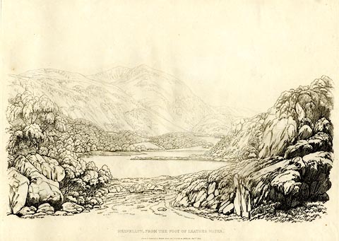 click to enlarge click to enlargeGN1228.jpg Plate 28 in Sixty Studies from Nature, 1810. printed at top right:- "28" printed at bottom:- "HELVELLYN, FROM THE FOOT OF LEATHES WATER. / Drawn &Engraved by William Green, and Published at Ambleside, Augst. 1st. 1809." watermark:- "J WHATMAN / 1813" item:- Armitt Library : A6641.28 Image © see bottom of page |
|||||||||||||||||||||||||
|
|
||||||||||||||||||||||||||
| evidence:- | old map:- Wallis 1810 (Cmd) placename:- Thurle Mere |
|||||||||||||||||||||||||
| source data:- | Road map, hand coloured engraving, Cumberland, scale about 16
miles to 1 inch, by James Wallis, 77 Berwick Stree, Soho,
London, 1810. click to enlarge click to enlargeWL13.jpg "Thurle Mere" outline, shaded; lake item:- Dove Cottage : 2009.81.10 Image © see bottom of page |
|||||||||||||||||||||||||
|
|
||||||||||||||||||||||||||
| evidence:- | old print:- Wilkinson 1810 (plate 17) placename:- Thirle Mere placename:- Leathes Water item:- boat; rowing boat |
|||||||||||||||||||||||||
| source data:- | Print, uncoloured soft ground etching, Thirle Mere or Leathes Water, Cumberland, by
Joseph Wilkinson, engraved by William Frederick Wells, published by R Ackermann, Repository
of Arts, 101 Strand, London, 1810.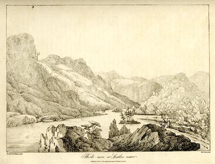 click to enlarge click to enlargeWKN117.jpg Plate 17 in Select Views in Cumberland, Westmoreland, and Lancashire. printed at bottom left, right, centre:- "The Revd. Jos: Wilkinson delt. / W. F. Wells Sculpt. / Thirle-mere or Leathes-water. / Publish'd Feby. 1. 1810. by R. Ackerman. 101. Strand. London." item:- Fell and Rock Climbing Club : MN4.17 Image © see bottom of page |
|||||||||||||||||||||||||
|
|
||||||||||||||||||||||||||
| evidence:- | old print:- Green 1814 (plate 25) placename:- Leaths Water item:- cattle |
|||||||||||||||||||||||||
| source data:- | Print, tinted soft ground etching, Leaths Water from Armbath, ie Thirlmere, St John's
Castlerigg and Wythburn, Cumberland, by William Green, Ambleside, Westmorland, 1814.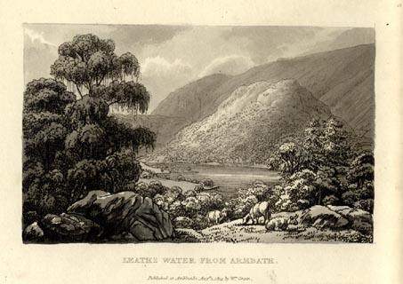 click to enlarge click to enlargeGN1025.jpg Plate 25 in Sixty Small Prints. printed at top right:- "25" printed at bottom:- "LEATHS WATER FROM ARMBATH. / Published at Ambleside Augst. 1, 1814, by Wm. Green." item:- Armitt Library : A6653.25 Image © see bottom of page |
|||||||||||||||||||||||||
|
|
||||||||||||||||||||||||||
| evidence:- | old print:- Green 1814 (plate 25) placename:- Leaths Water item:- cattle |
|||||||||||||||||||||||||
| source data:- | Print, uncoloured soft ground etching, Leaths Water from Armbath, ie Thirlmere, St
John's Castlerigg and Wythburn, Cumberland, by William Green, Ambleside, Westmorland,
1814.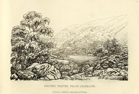 click to enlarge click to enlargeGN0925.jpg Plate 25 in Sixty Small Prints. printed at top right:- "25" printed at bottom:- "LEATHS WATER FROM ARMBATH. / Published at Ambleside Augst. 1, 1814, by Wm. Green." item:- Armitt Library : A6656.25 Image © see bottom of page |
|||||||||||||||||||||||||
|
|
||||||||||||||||||||||||||
| evidence:- | old print:- Green 1814 (plate 26) placename:- Leath's Water |
|||||||||||||||||||||||||
| source data:- | Print, tinted soft ground etching, Foot of Leaths Water, ie Thirlmere, St John's Castlerigg
and Wythburn, Cumberland, by William Green, Ambleside, Westmorland, 1814.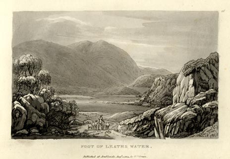 click to enlarge click to enlargeGN1026.jpg Plate 26 in Sixty Small Prints. printed at top right:- "26" printed at bottom:- "FOOT OF LEATHS WATER. / Published at Ambleside Augst. 1, 1814, by Wm. Green." item:- Armitt Library : A6653.26 Image © see bottom of page |
|||||||||||||||||||||||||
|
|
||||||||||||||||||||||||||
| evidence:- | old print:- Green 1814 (plate 26) placename:- Leath's Water |
|||||||||||||||||||||||||
| source data:- | Print, uncoloured soft ground etching, Foot of Leaths Water, ie Thirlmere, St John's
Castlerigg and Wythburn, Cumberland, by William Green, Ambleside, Westmorland, 1814.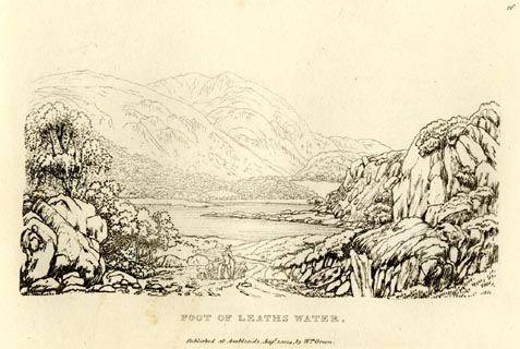 click to enlarge click to enlargeGN0926.jpg Plate 26 in Sixty Small Prints. printed at top right:- "26" printed at bottom:- "FOOT OF LEATHS WATER. / Published at Ambleside Augst. 1, 1814, by Wm. Green." item:- Armitt Library : A6656.26 Image © see bottom of page |
|||||||||||||||||||||||||
|
|
||||||||||||||||||||||||||
| evidence:- | old text:- Green 1814 placename:- Leath's Water placename:- Thirl Mere placename:- Wyburn Water |
|||||||||||||||||||||||||
| source data:- | Set of prints, soft ground etchings, Sixty Small Prints, with
text, A Description of a Series of Sixty Small Prints, by
William Green, Ambleside, Westmorland, 1814. goto source page 13:- "..." "Leath's Water, Thirl Mere, or, as it is most commonly called, Wyburn Water, is seen only to advantage from the western side; and had the elegant Mrs. Radcliffe traversed that beautiful side, she would not have had occasion to say, "this is a long and unadorned lake, having little else than walls of rocky fells starting from its margin." This almost unparalleld line, of four miles in length, is not accessible to carriages; horses may travel it, and persons on foot without any considerable impediment." "..." goto sourcepage 14:- "..." "Leath's Water takes this name from the family of Leath, who have long resided at Dalehead, a venerable edifice on the banks of the lake." |
|||||||||||||||||||||||||
|
|
||||||||||||||||||||||||||
| evidence:- | old print:- Green 1815 placename:- Leaths Water |
|||||||||||||||||||||||||
| source data:- | Print, coloured aquatint, Leaths Water, St John's Castlerigg and Wythburn, Cumberland,
by William Green, Ambleside, Westmorland, 1815.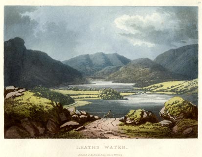 click to enlarge click to enlargeGN0531.jpg The northern part of Thirlmere; Wath Bridge then Wythburn Water behind. Plate 33 in Lake Scenery. printed at upper right:- "33" printed at bottom:- "LEATHS WATER. / Published at Ambleside, June 1, 1815, by Wm. Green." item:- Armitt Library : A6646.31 Image © see bottom of page |
|||||||||||||||||||||||||
|
|
||||||||||||||||||||||||||
| evidence:- | old print with text:- Farington 1816 placename:- Thirlmere placename:- Leathes Water placename:- Wyburn Lake |
|||||||||||||||||||||||||
| source data:- | Print, uncoloured engraving and descriptive text, Thirlmere, St John's Castlerigg
and Wythburn, Cumberland, drawn by Joseph Farington, engraved by F R Hay, published
by T Cadell and W Davies, Strand, London, 1815.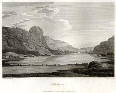 click to enlarge click to enlargeFA0413.jpg printed, bottom left, right, centre "Drawn by J. Farington R.A. / Engraved by F. R. Hay. / Thirlmere. / London Published Septr. 15, 1815, by T. Cadell &W. Davies, Strand." Descriptive text:- "THIRLMERE, or LEATHES-WATER, (sometimes also called Wyburn Lake) is situated about five miles from Keswick, on the road to Ambleside: it is a narrow irregular sheet of water, between two and three miles in length, skirting the immense base of Helvellyn, and receiving a variety of torrents from the sides of that huge mountain. This Lake in no part exceeds one mile in breadth: it lies in the interior of a very sequestered district bordering on Westmoreland. No tufted verdure graces its banks, nor hanging woods throw rich reflections on its surface; but every form which it suggests is savage and desolate. The effect of this scene is much heightened by the appearance of the immense craggy masses, which seem to hang on the sides of Helvellyn, whence they have apparently been severed: others of them are seen shelving into the Lake, while other masses have reached the bottom, and are at rest in the silent water. ..." item:- Armitt Library : A6666.13 Image © see bottom of page |
|||||||||||||||||||||||||
|
|
||||||||||||||||||||||||||
| evidence:- | old map:- Otley 1818 placename:- Thirlmere |
|||||||||||||||||||||||||
| source data:- | Map, uncoloured engraving, The District of the Lakes,
Cumberland, Westmorland, and Lancashire, scale about 4 miles to
1 inch, by Jonathan Otley, 1818, engraved by J and G Menzies,
Edinburgh, Scotland, published by Jonathan Otley, Keswick,
Cumberland, et al, 1833. OT02NY31.jpg item:- JandMN : 48.1 Image © see bottom of page |
|||||||||||||||||||||||||
|
|
||||||||||||||||||||||||||
| evidence:- | old map:- Hall 1820 (Cmd) placename:- Thurl Meer |
|||||||||||||||||||||||||
| source data:- | Map, hand coloured engraving, Cumberland, scale about 21 miles
to 1 inch, engraved by Sidney Hall, published by S Leigh, 18
Strand, London, 1820-31. click to enlarge click to enlargeHA14.jpg "Thurl Meer" outline, shaded; lake item:- JandMN : 91 Image © see bottom of page |
|||||||||||||||||||||||||
|
|
||||||||||||||||||||||||||
| evidence:- | old print:- Fielding and Walton 1821 (plate 23) placename:- Wythburn Water |
|||||||||||||||||||||||||
| source data:- | Print, coloured aquatint, Wythburn Water and Helvellyn, Cumberland, drawn by Theodore
H A Fielding, published by R Ackermann, 101 Strand, London, 1821.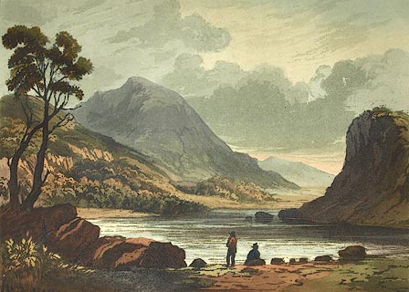 click to enlarge click to enlargeFW0123.jpg Thirlmere. Tipped in opposite p.125 in A Picturesque Tour of the English Lakes. item:- Dove Cottage : 1993.R566.23 Image © see bottom of page |
|||||||||||||||||||||||||
|
|
||||||||||||||||||||||||||
| evidence:- | descriptive text:- Otley 1823 (5th edn 1834) placename:- Leathes Water placename:- Wythburn Water item:- depth, Thirlmere |
|||||||||||||||||||||||||
| source data:- | Guide book, A Concise Description of the English Lakes, the
mountains in their vicinity, and the roads by which they may be
visited, with remarks on the mineralogy and geology of the
district, by Jonathan Otley, published by the author, Keswick,
Cumberland now Cumbria, by J Richardson, London, and by Arthur
Foster, Kirkby Lonsdale, Cumbria, 1823; published 1823-49,
latterly as the Descriptive Guide to the English Lakes. goto source Page 16:- "THIRLMERE" "- Commonly called LEATHES' WATER, from the family to whose estate it belongs; and sometimes WYTHBURN WATER, from the valley in which it is partly situated - lies at the foot of the 'mighty Helvellyn;' upon the highest level of any of the lakes, being near 500 feet above the sea; it is upwards of two miles and a half in length, and intersected by several rocky promontories; it is divided into an upper and lower lake, between which a picturesque wooden bridge leads to Armboth House. The depth of this lake, which has been reported to be very great, has not been found to exceed eighteen fathoms. A wooded island, of half an acre, lies near the shore, on the lower, or northern part of the lake; and the surface of the water being of late somewhat lowered by opening its outlet, a small rock in the upper part has become more conspicuous." "Travellers are commonly satisfied with a sight of this lake from the road; but those who have leisure may obtain better views of the lower and finer part of the lake, from different stations in the grounds near Dalehead House; and finer still from the other side of the water. But the most perfect view of the whole lake is from a rocky eminence at a little distance from the northern end of the water." |
|||||||||||||||||||||||||
|
|
||||||||||||||||||||||||||
| evidence:- | old print:- Westall 1830s placename:- Leathes Water placename:- Thirlmere |
|||||||||||||||||||||||||
| source data:- | Print, aquatint panorama, Leathes Water or Thirlmere, from the West Side, Cumberland,
drawn and engraved by William Westall, published by Ackermann and Co, 96 Strand, London,
1833.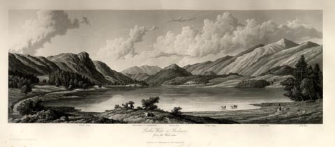 click to enlarge click to enlargeWTL311.jpg "Raven Crag. Blencathra or Saddleback. Great How. Green Crag. Great Dod. Helvellyn. / Leathes Water or Thirlmere, / from the West side. / Drawn & Engraved by W. Westall A.R.A. / Published by Ackermann and Co, 96 Strand. 1833." item:- Armitt Library : A6658.11 Image © see bottom of page |
|||||||||||||||||||||||||
|
|
||||||||||||||||||||||||||
| evidence:- | descriptive text:- Ford 1839 (3rd edn 1843) placename:- Leathes Water placename:- Thirlmere placename:- Wythburn Water placename:- Brackmere item:- depth, Thirlmere |
|||||||||||||||||||||||||
| source data:- | Guide book, A Description of Scenery in the Lake District, by
Rev William Ford, published by Charles Thurnam, Carlisle, by W
Edwards, 12 Ave Maria Lane, Charles Tilt, Fleet Street, William
Smith, 113 Fleet Street, London, by Currie and Bowman,
Newcastle, by Bancks and Co, Manchester, by Oliver and Boyd,
Edinburgh, and by Sinclair, Dumfries, 1839. goto source Page 47:- "..." "LEATHES WATER." "The [Horse Head] inn is a mile from the head of the lake, which is known by the several names of Leathes Water, Thirlmere, Wythburn Water, and Brackmere. It is about three miles in length, though rarely exceeding a quarter of a mile in breadth; the depth is not above eighteen fathoms, and its waters, which are the most elevated of any, are not remarkable for clearness. Pike, trout, and perch, are the chief fish. It is nearly equally divided by two promontories, connected by a series of wooden bridges and stone causeways at a place where it is fordable. The lower half, containing a small island, presents the most beautiful views; the upper part being more remarkable for wildness and sublimity. Tourists are generally content with" goto sourcePage 48:- "a sight of this lake from the high road, but the western side ought not on any account to be passed by without a perambulation. This mere is fed by two streams; the main one rising in Wythburn Head; the other, not much inferior, pours down a rocky gill, after issuing out of Harrop Tarn, a marshy water of considerable size, situated at the foot of a precipice, in a coom on the western side of the valley." "'There sometimes doth the leaping fish Send through the tarn a lonely cheer; The crag repeats the raven's croak, In symphony austere; Thither the rainbow comes - the cloud - And mists that spread the flying shroud.'" "In order to see this vale from its western side, cross the meadows from the inn to a few white cottages, enlivened by the green leaves of the cheerful hollin tree, called the City, a corruption undoubtedly from some more homely epithet; thence the road, not suitable for modern carriages, leads under towering precipices and crags to an eminence or rather promontory jutting into the lake, from which Helvellyn appears to rise directly and perpendicularly out of the water. In front, is the upper lake and alpine bridges, separating it from the lower reach, with the wood-crested How and Naddle Fell on one hand, on the other, the black and storm-shattered fronts of Fisher and Raven Crags; and often between these rocky frames Blencathra hangs suspended in aerial blue. In a coom on the left, between Bull Crag and Fisher" goto sourcePage 49:- "Crag, are the Deargarth Cascades. Armboth House is pleasantly situated on the top of a gentle eminence under the Fells, whence the ground falls in easy slopes all round to the water's edge: the views from the house are commanding, and the eye rests upon the huge surfaces of Helvellyn and the Great Dodd. Raven Crag is a mighty mass of dark, frowning crags, that have braved the fury of many a storm. From its foot, looking diagonally across the lake, Dalehead Hall, amid woods of a modern growth, and, for the first time, the summit of Helvellyn, form a magnificent picture. Hence to the outlet of the lake, where the river may be watched, forming still pools between low meadows of green pasture, and stealing quietly and rather sluggishly away to foam and chafe with the rocks and wilds of Legberthwaite, the traveller will shortly after join the direct road, from which he had diverged in the dreary moss of Shoolthwaite." "From the Horse Head inn, the carriage-road winds under Helvellyn by the margin of the lake, which it leaves by a very steep ascent. This side of the dale presents the sternest features, seen, too, most impressively -" "' When the storm Rides high - when all the upper air is fill'd With roaring sound, that ceases not to flow Like smoke, along the level of the blast.'" goto sourcePage 164:- "..." "... A little beyond this dreary and wind-swept pass [Dunmail Raise], there is a view, forward, of the cold and forbidding vale and water of Wythburn, bounded by the sloping sides of Helvellyn and Seat Sandal on the right, and by the Borrodale fells on the left, with Skiddaw closing in the view to the north." "..." "Wythburn Water, known also as Thirlmere or Leathes Water, is a narrow and deep lake, divided" goto sourcePage 165:- "into two by a wooden bridge and piers. The lower end of this water ought to be visited, and a pleasant, agreeable tour may be made from Keswick, by approaching it along Shoolthwaite Moss, keeping up its western side, under Raven Crag, as far as Armboth House. Here crossing the lake, pass through Dalehead Park into the public road; thence through Legberthwaite, having the castle rock of St. John's on the right, to Threlkeld, and so to Keswick." goto sourcePage 177:- "A TABLE" "OF THE LENGTH, BREADTH, &c. OF THE LAKES," "COLLECTED FROM DIFFERENT AUTHORITIES."
|
|||||||||||||||||||||||||
|
|
||||||||||||||||||||||||||
| evidence:- | old map:- Ford 1839 map placename:- Thirle Water |
|||||||||||||||||||||||||
| source data:- | Map, uncoloured engraving, Map of the Lake District of
Cumberland, Westmoreland and Lancashire, scale about 3.5 miles
to 1 inch, published by Charles Thurnam, Carlisle, and by R
Groombridge, 5 Paternoster Row, London, 3rd edn 1843. FD02NY31.jpg "Thirle Water" Outline with form lines. item:- JandMN : 100.1 Image © see bottom of page |
|||||||||||||||||||||||||
|
|
||||||||||||||||||||||||||
| evidence:- | old drawing:- Aspland 1840s-60s placename:- Thirlmere |
|||||||||||||||||||||||||
| source data:- | Drawing, pencil, Thirlmere, Cumberland, by Theophilus Lindsey Aspland, 17 May 1853.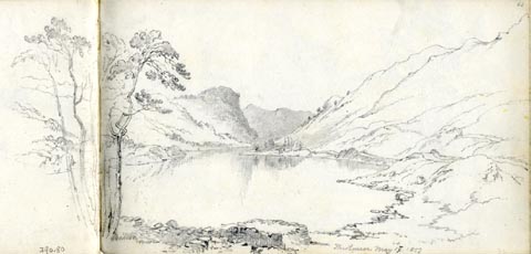 click to enlarge click to enlargeAS0380.jpg "Thirlmere May 17. 1853." page number "63" item:- Armitt Library : 1958.390.80 Image © see bottom of page |
|||||||||||||||||||||||||
|
|
||||||||||||||||||||||||||
| evidence:- | old drawing:- Aspland 1840s-60s placename:- Leath's Water |
|||||||||||||||||||||||||
| source data:- | Drawing, pencil, Leath's Water ie Thirlmere, from Bucks Holm, Cumberland, by Theophilus
Lindsey Aspland, 1849.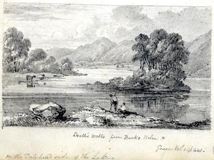 click to enlarge click to enlargeAS0182.jpg "Leath's Water from Bucks Holm. / Green Vol 1. p 441. / on the Dalehead side of the Lake." item:- Armitt Library : 1958.487.81.2 Image © see bottom of page |
|||||||||||||||||||||||||
|
|
||||||||||||||||||||||||||
| evidence:- | old map:- Wyld 1847 placename:- Thirlmere Lake |
|||||||||||||||||||||||||
| source data:- | Map, uncoloured engraving, Thirlmere, Derwentwater, and
Bassenthwaite Lakes, scale about 3.5 miles to 1 inch, by James
Wyld, published by John Johnstone, Paternoster Row, London, et
al, 1847. click to enlarge click to enlargeWLD3M2.jpg printed at bottom:- "THIRLMERE, DERWENTWATER, / AND BASSENTHWAITE LAKES." item:- Armitt Library : A1201.65 Image © see bottom of page |
|||||||||||||||||||||||||
|
|
||||||||||||||||||||||||||
| evidence:- | old map:- Garnett 1850s-60s H placename:- Thirl Mere |
|||||||||||||||||||||||||
| source data:- | Map of the English Lakes, in Cumberland, Westmorland and
Lancashire, scale about 3.5 miles to 1 inch, published by John
Garnett, Windermere, Westmorland, 1850s-60s. GAR2NY31.jpg "THIRL MERE" outline with shore form lines, lake or tarn item:- JandMN : 82.1 Image © see bottom of page |
|||||||||||||||||||||||||
|
|
||||||||||||||||||||||||||
| evidence:- | old print:- Pyne 1853 placename:- Thirlmere |
|||||||||||||||||||||||||
| source data:- | Print, tinted lithograph, Thirlmere and Wytheburn, Cumberland, by James Baker Pyne,
engraved by W Gauci, published by Thomas Agnew and Sons, Manchester, Lancashire, 1853.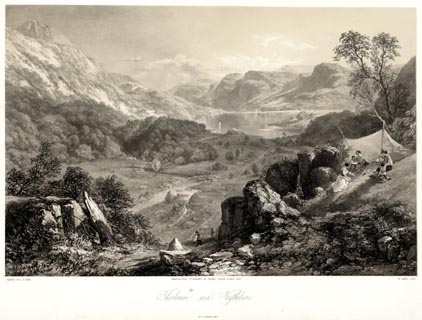 click to enlarge click to enlargePYN223.jpg "PAINTED BY J. B. PYNE. / W. GAUCI LITH. / MANCHESTER, PUBLISHED BY THOMAS AGNEW & SONS, 1853. / Thirlmere and Wytheburn / M & N HANHART IMPT." item:- Armitt Library : A6678.24 Image © see bottom of page |
|||||||||||||||||||||||||
|
|
||||||||||||||||||||||||||
| evidence:- | old print:- Pyne 1853 placename:- Thirlmere |
|||||||||||||||||||||||||
| source data:- | Print, coloured lithograph, Thirlmere and Wytheburn, Cumberland, by James Baker Pyne,
engraved by W Gauci, published by Thomas Agnew and Sons, Manchester, Lancashire, 1853.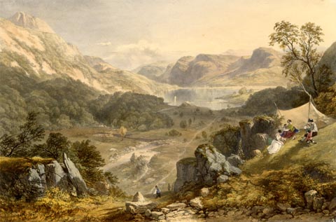 click to enlarge click to enlargePYN423.jpg item:- Armitt Library : A6677.24 Image © see bottom of page |
|||||||||||||||||||||||||
|
|
||||||||||||||||||||||||||
| evidence:- | Pyne 1853 item:- Polyolbion; Drayton, Michael |
|||||||||||||||||||||||||
| source data:- | Set of prints, The Lake Scenery of England, or The English Lake District, scenes painted
by James Baker Pyne, lithographed by W Gauci, published by Thomas Agnew and Sons,
Manchester, 1853; published 1853-70. the descriptive text to plate 22, Thirlmere, painted by James Baker Pyne, in The English Lake District, has:- "In some fine lines, the leading idea if which is borrowed from Drayton's "Polyolbion," Mr. Wordsworth thus describes the effect of echoes among the mountains in this vicinity. A young lady (whose lungs must have tolerably vigourous) "laughed aloud:" -"The rock, like something starting from a sleep, Took up the lady's voice and laughed again; That ancient woman seated on Helmcrag Was ready with her cavern; Hammarscar, And the tall steep of Silver Brow, sent forth A noise of laughter; southern loughrigg heard, And Fairfield answered with a mountain tone; Helvellyn far into the clear blue sky Carried the lady's voice; old Skiddaw blew His speaking-trumpet; back out of the clouds Of Glaramara, southward, came the voice; And Kirkstone toss'd it from its misty head."" |
|||||||||||||||||||||||||
|
|
||||||||||||||||||||||||||
| evidence:- | old text:- Martineau 1855 placename:- Wythburn Water placename:- Leathes Water placename:- Thirlmere |
|||||||||||||||||||||||||
| source data:- | Guide book, A Complete Guide to the English Lakes, by Harriet
Martineau, published by John Garnett, Windermere, Westmorland,
and by Whittaker and Co, London, 1855; published 1855-76. goto source Page 69:- "[Thirlmere] known by the various names of Wythburn Water, Leathes Water, and Thirlmere. ..." |
|||||||||||||||||||||||||
|
|
||||||||||||||||||||||||||
| evidence:- | old text:- Martineau 1855 item:- depth, Thirlmere |
|||||||||||||||||||||||||
| source data:- | Guide book, A Complete Guide to the English Lakes, by Harriet
Martineau, published by John Garnett, Windermere, Westmorland,
and by Whittaker and Co, London, 1855; published 1855-76. goto source Page 180:- "A TABLE OF THE LENGTH, BREADTH, AND DEPTH OF THE LAKES." "No. : Names of Lakes. : Counties : Length in Miles. : Extreme breadth in Miles : Extreme depth in Feet : Height above the Sea" "17 : Thirlmere : Cumberland : 2¾ : ½: 108 : 473" |
|||||||||||||||||||||||||
|
|
||||||||||||||||||||||||||
| evidence:- | old text:- Gents Mag item:- water supply |
|||||||||||||||||||||||||
| source data:- | Magazine, The Gentleman's Magazine or Monthly Intelligencer or
Historical Chronicle, published by Edward Cave under the
pseudonym Sylvanus Urban, and by other publishers, London,
monthly from 1731 to 1922. goto source Gentleman's Magazine 1877 part 2 p.633 "TABLE-TALK." "DUNMAIL RAISE and the Valley of Wythburn are threatened next year with an invasion which has excited the indignation not only of the principal dwellers in one of the loveliest nooks in the very heart of the English lake district, but has awakened painful surprise and opposition all over the country, wherever the love of natural beauty, and the reverence for famous men whose footsteps have doubly hallowed it, are not yet quite extinct. A ruthless piece of vandalism is contemplated which it is to be hoped may yet be baffled by a firm and united resistance. Parliament is to be asked in the approaching session to empower the Manchester Corporation to turn the beautiful lake of Thirlmere into a reservoir for supplying with water, not Manchester alone - for that city, they own, has an ample supply for the next twenty years to come - but the various towns en route. Only dire and extreme necessity, and an absolute impossibility of obtaining water elsewhere, could justify this proposal. Neither of these conditions fortunately exists. "Not one tithe," as Mr. Somervell, the chief and indefatigable opponent of the scheme, has pointed out, "of the moorland available for the supply of water of Manchester, between the Lune and South Lancashire, has been utilised as yet." To carry out the scheme proposed a huge embankment would have to be reared to the height of at least 70 feet, thus lengthening the lake from 21/2 to 41/2miles, and deepening it to the extent of 60 or 70 feet. This would have the effect of placing under water the whole valley, and the beauties of the spot would be buried in a deep dark reservoir. "It is the intention of the Waterworks Committee," naively remarks the Cumberland Times, "to substitute for the present tortuous up-and-down track a straight road cut on a level line around the slopes of Helvellyn. Below it the lake, enlarged to more than twice its present dimensions, will assume a grandeur of appearance in more striking accordance with its majestic surroundings. HOW THE VALLEY WILL LOOK IN THE DRY SUMMER SEASON, WHEN THE RESERVOIR IS HALF EMPTIED, HAS YET TO BE ASCERTAINED." Another ground of opposition to the scheme is its danger as well as it unsightliness. In the very possible and even probable event of" |
|||||||||||||||||||||||||
|
|
||||||||||||||||||||||||||
| evidence:- | old text:- Gents Mag 1877 item:- Thirlmere Defence Fund; Manchester and Thirlmere Scheme, An Appeal to the Public on the Facts of the Case |
|||||||||||||||||||||||||
| source data:- | goto source Gentleman's Magazine 1877 part 2 p.634 "one of the floods or heavy rainfalls to which the district is peculiarly liable bearing down the embankment, the whole surrounding district, Keswick, Grasmere, and every bridge along the Cockermouth Keswick and Penrith railway would be swept away. Mr. J. F. Bateman, the engineer to the Corporation, is pleased to assert in his report, that "the uses to which the water can be locally applied are small and insignificant." Upon the same principle the inhabitants of Bethnal Green might propose that we should, in the ensuing winter, fell down the trees in Kensington Gardens and in Richmond Park to supply them with firewood, because "the uses to which the wood can be locally applied are small and insignificant." This is, surely, utilitarianism run mad. Mr. Robert Somervell, of Hazelthwaite, Windermere, has just published a pamphlet in which the chief arguments against the scheme are ably and forcilbly stated. This is entitles, "The Manchester and Thirlmere Scheme: An Appeal to the Public on the Facts of the Case." Mr. Somervell will, I believe, be happy to afford further information to anyone desirous of aiding to oppose the scheme, for which purpose an influential committee of gentlemen of the district, among whom we are somewhat disappointed not to find the name of Mr. Ruskin, has also been formed, and subscriptions for the "Thirlmere Defence Fund" have already been raised to the amount of over a thousand pounds." "... ..." |
|||||||||||||||||||||||||
|
|
||||||||||||||||||||||||||
| evidence:- | old text:- Gents Mag item:- haunted house |
|||||||||||||||||||||||||
| source data:- | Magazine, The Gentleman's Magazine or Monthly Intelligencer or
Historical Chronicle, published by Edward Cave under the
pseudonym Sylvanus Urban, and by other publishers, London,
monthly from 1731 to 1922. goto source Gentleman's Magazine 1878 part 1 p.124 "..." "AMONG the many reasons, most of them valid ones, against making Thirlmere, one of the most charming of the English Lakes, a Manchester reservoir, is that such a proceeding will probably destroy one of the few specimens of haunted houses we have still left in England. It is Miss Martineau who tells us of that lonely residence under Armboth Fell, where the lights are seen in the empty banqueting-chamber, and the spectral dog welcomes the invisible" |
|||||||||||||||||||||||||
|
|
||||||||||||||||||||||||||
| evidence:- | old text:- Gents Mag 1878 |
|||||||||||||||||||||||||
| source data:- | goto source Gentleman's Magazine 1878 part 1 p.125 "guests. If the lake is raised, as intended, forty feet, those lights will be put out, and the dog will be drowned! May Cottonopolis be sent nearer home for its water supply, and not interfere with the public pleasure in things on which it has itself never set any value: the solemnity of solitude, the unruffled aspect of Nature, the glories of the mountain, the peacefulness of the mere!" "There was a certain sonnet written once, which has a very direct reference to this untilitarian invasion:" "Is there no nook of English ground secure from rash assault, ... ... ... ... ... ... Plead for thy peace, thou beautiful romance Of Nature; and if human hearts be dead Speak, passing winds; ye torrents with your strong And constant voice protest against this wrong." "If Wordsworth had lived to hear of the present outrage, he would have claimed (almost) with Lear, "Ye Aqueducts, burst."" "..." |
|||||||||||||||||||||||||
|
|
||||||||||||||||||||||||||
| evidence:- | old print:- Nelson 1853 (edn 1880s) placename:- Thirlmere |
|||||||||||||||||||||||||
| source data:- | Print, chromolithograph, Thirlmere, St John's Castlerigg and Wythburn, Cumberland,
published by Thomas Nelson and Sons, London, 1880s?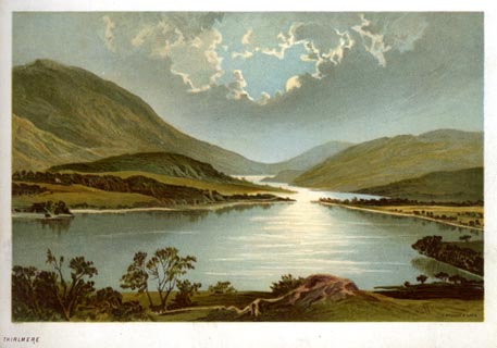 click to enlarge click to enlargeNS0328.jpg At the end of Views of the English Lakes, and Tourists Guide to the English Lakes. printed at bottom:- "THIRLMERE" item:- JandMN : 474.29 Image © see bottom of page |
|||||||||||||||||||||||||
|
|
||||||||||||||||||||||||||
| evidence:- | old photograph:- Bell 1880s-1940s |
|||||||||||||||||||||||||
| source data:- | Photograph, black and white, Thirlmere, looking south, before flooding, St John's
Castlerigg and Wythburn, Cumberland, by Herbert Bell, photographer, Ambleside, Westmorland,
1890s.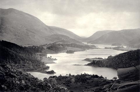 click to enlarge click to enlargeHB0916.jpg internegative at lower left:- "H. Bell" stamped at reverse:- "HERBERT BELL / Photographer / AMBLESIDE" item:- Armitt Library : ALPS591 Image © see bottom of page |
|||||||||||||||||||||||||
|
|
||||||||||||||||||||||||||
| evidence:- | old photograph:- Bell 1880s-1940s |
|||||||||||||||||||||||||
| source data:- | Photograph, black and white, Thirlmere, looking south, before flooding, St John's
Castlerigg and Wythburn, Cumberland, by Herbert Bell, photographer, Ambleside, Westmorland,
1890s.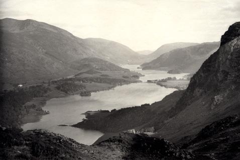 click to enlarge click to enlargeHB0917.jpg internegative at lower left:- "H. Bell" item:- Armitt Library : ALPS592 Image © see bottom of page |
|||||||||||||||||||||||||
|
|
||||||||||||||||||||||||||
| evidence:- | old photograph:- Bell 1880s-1940s |
|||||||||||||||||||||||||
| source data:- | Photograph, black and white, Thirlmere, looking north, before flooding, St John's
Castlerigg and Wythburn, Cumberland, by Herbert Bell, photographer, Ambleside, Westmorland,
1890s.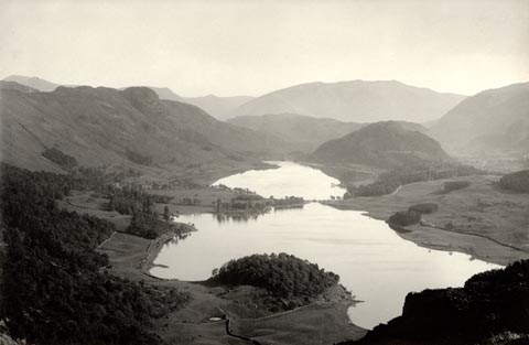 click to enlarge click to enlargeHB0918.jpg item:- Armitt Library : ALPS593 Image © see bottom of page |
|||||||||||||||||||||||||
|
|
||||||||||||||||||||||||||
| evidence:- | old photograph:- Bell 1880s-1940s |
|||||||||||||||||||||||||
| source data:- | Photograph, black and white, Thirlmere, looking north from the Rocking Stone, before
flooding, St John's Castlerigg and Wythburn, Cumberland, by Herbert Bell, photographer,
Ambleside, Westmorland, 1890s.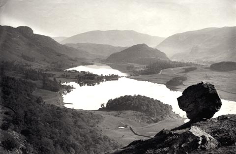 click to enlarge click to enlargeHB0919.jpg item:- Armitt Library : ALPS594 Image © see bottom of page |
|||||||||||||||||||||||||
|
|
||||||||||||||||||||||||||
| evidence:- | old photograph:- Bell 1880s-1940s |
|||||||||||||||||||||||||
| source data:- | Photograph, sepia, Thirlmere and Raven Crag? St John's Castlerigg and Wythburn, Cumberland,
by Herbert Bell, photographer, Ambleside, Westmorland, 1890s.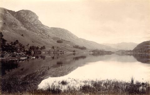 click to enlarge click to enlargeHB0920.jpg item:- Armitt Library : ALPS595 Image © see bottom of page |
|||||||||||||||||||||||||
|
|
||||||||||||||||||||||||||
| evidence:- | old photograph:- Bell 1880s-1940s |
|||||||||||||||||||||||||
| source data:- | Photograph, black and white, Helvellyn and Thirlmere, St John's Castlerigg and Wythburn,
Cumberland, by Herbert Bell, photographer, Ambleside, Westmorland, 1890s?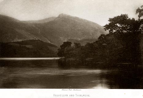 click to enlarge click to enlargeHB0951.jpg printed at bottom:- "Herbert Bell, Ambleside / HELVELLYN AND THIRLMERE" item:- Armitt Library : 1958.4256 Image © see bottom of page |
|||||||||||||||||||||||||
|
|
||||||||||||||||||||||||||
| evidence:- | old photograph:- Bell 1880s-1940s item:- fence |
|||||||||||||||||||||||||
| source data:- | Photograph, sepia, Thirlmere, the island? St John's Castlerigg and Wythburn, Cumberland,
by Herbert Bell, photographer, Ambleside, Westmorland, 1890s.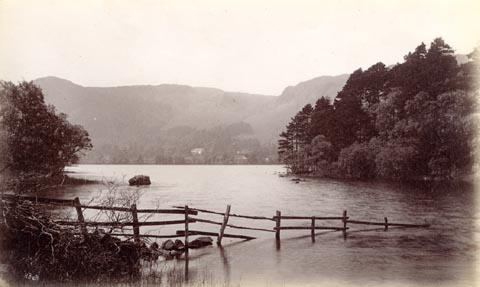 click to enlarge click to enlargeHB0735.jpg internegative at lower left:- "H. Bell" item:- Armitt Library : ALPS399 Image © see bottom of page |
|||||||||||||||||||||||||
|
|
||||||||||||||||||||||||||
| evidence:- | old photograph:- Bell 1880s-1940s item:- swan; reflections |
|||||||||||||||||||||||||
| source data:- | Photograph, sepia, head of Thirlmere, St John's Castlerigg and Wythburn, Cumberland,
by Herbert Bell, photographer, Ambleside, Westmorland, 1890s.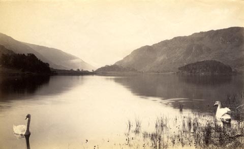 click to enlarge click to enlargeHB0734.jpg internegative at lower right:- "H. Bell" item:- Armitt Library : ALPS398 Image © see bottom of page |
|||||||||||||||||||||||||
|
|
||||||||||||||||||||||||||
| evidence:- | old photograph:- Bell 1880s-1940s item:- swan |
|||||||||||||||||||||||||
| source data:- | Photograph, sepia, Thirlmere, from near Wath Bridge, St John's Castlerigg and Wythburn,
Cumberland, by Herbert Bell, photographer, Ambleside, Westmorland, 1890s.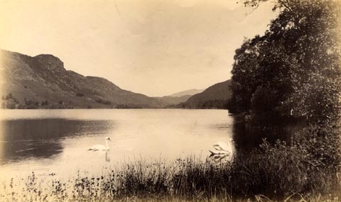 click to enlarge click to enlargeHB0732.jpg internegative at lower right:- "H. Bell" item:- Armitt Library : ALPS396 Image © see bottom of page |
|||||||||||||||||||||||||
|
|
||||||||||||||||||||||||||
| evidence:- | old photograph:- Bell 1880s-1940s |
|||||||||||||||||||||||||
| source data:- | Photograph, black and white, Thirlmere from the Rocking Stone, St John's Castlerigg
and Wythburn, Cumberland, by Herbert Bell, photographer, Ambleside, Westmorland, 1890s.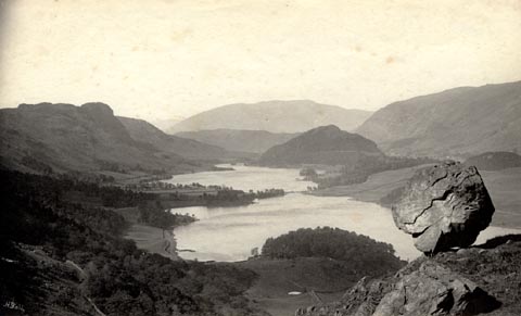 click to enlarge click to enlargeHB0727.jpg internegative at lower left:- "H. Bell" item:- Armitt Library : ALPS391 Image © see bottom of page |
|||||||||||||||||||||||||
|
|
||||||||||||||||||||||||||
| evidence:- | old photograph:- Bell 1880s-1940s |
|||||||||||||||||||||||||
| source data:- | Photograph, sepia, Thirlmere looking past Helvellyn, before flooding, St John's Castlerigg
and Wythburn, Cumberland, by Herbert Bell, photographer, Ambleside, Westmorland, 1890s.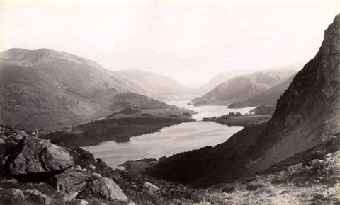 click to enlarge click to enlargeHB0726.jpg internegative at lower right:- "H. Bell" item:- Armitt Library : ALPS390 Image © see bottom of page |
|||||||||||||||||||||||||
|
|
||||||||||||||||||||||||||
| evidence:- | old photograph:- Bell 1880s-1940s |
|||||||||||||||||||||||||
| source data:- | Photograph, black and white, Thirlmere looking past Helvellyn, after flooding, St
John's Castlerigg and Wythburn, Cumberland, by Herbert Bell, photographer, Ambleside,
Westmorland, 1890s.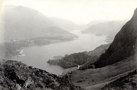 click to enlarge click to enlargeHB0725.jpg stamped on reverse:- "HERBERT BELL / Photographer / AMBLESIDE" item:- Armitt Library : ALPS389 Image © see bottom of page |
|||||||||||||||||||||||||
|
|
||||||||||||||||||||||||||
| evidence:- | old photograph:- Bell 1880s-1940s |
|||||||||||||||||||||||||
| source data:- | Photograph, black and white, Thirlmere, looking towards Saddleback, after flooding,
St John's Castlerigg and Wythburn, Cumberland, by Herbert Bell, photographer, Ambleside,
Westmorland, 1890s.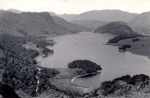 click to enlarge click to enlargeHB0724.jpg stamped on reverse:- "HERBERT BELL / Photographer / AMBLESIDE" item:- Armitt Library : ALPS388 Image © see bottom of page |
|||||||||||||||||||||||||
|
|
||||||||||||||||||||||||||
| evidence:- | old photograph:- Bell 1880s-1940s |
|||||||||||||||||||||||||
| source data:- | Photograph, black and white, Thirlmere, looking towards Saddleback, before flooding,
St John's Castlerigg and Wythburn, Cumberland, by Herbert Bell, photographer, Ambleside,
Westmorland, 1890s.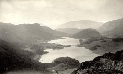 click to enlarge click to enlargeHB0723.jpg internegative at lower left:- "H. Bell" item:- Armitt Library : ALPS387 Image © see bottom of page |
|||||||||||||||||||||||||
|
|
||||||||||||||||||||||||||
| evidence:- | old photograph:- Bell 1880s-1940s |
|||||||||||||||||||||||||
| source data:- | Photograph, black and white, Thirlmere looking past Helvellyn, before flooding? St
John's Castlerigg and Wythburn, Cumberland, by Herbert Bell, photographer, Ambleside,
Westmorland, 1890s.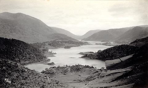 click to enlarge click to enlargeHB0722.jpg internegative at lower left:- "H. Bell" item:- Armitt Library : ALPS386 Image © see bottom of page |
|||||||||||||||||||||||||
|
|
||||||||||||||||||||||||||
| evidence:- | old print:- Bemrose 1881 placename:- Thirlmere |
|||||||||||||||||||||||||
| source data:- | Print, uncoloured, Thirlmere, Cumberland, published by Bemrose and Sons, 23 Old Bailey,
London and Derby, by A B Moss, Carlisle, Cumberland, and by T Wilson, Kendal, Westmorland,
about 1881.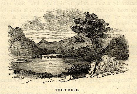 click to enlarge click to enlargeBEM117.jpg On p.62 of a Handy Guide to the English Lakes and Shap Spa. printed at bottom:- "THIRLMERE." item:- JandMN : 455.19 Image © see bottom of page |
|||||||||||||||||||||||||
|
|
||||||||||||||||||||||||||
| evidence:- | old text:- Philip/Wilson 1890s placename:- |
|||||||||||||||||||||||||
| source data:- | Guide book, The English Lake District, published by George
Philip and Son, 32 Fleet Street, London, Philip, Son and Nephew,
Liverpool, Lancashire, and Titus Wilson, Kendal, Westmorland,
now Cumbria, before 1895. Written after the conversion of the lake to a reservoir:- "Formerly it was barely 3 miles in length, now it is 3⅝ miles. It was about ¼of a mile broad, but so narrowed at one point that it was crossed by three successive foot-bridges,- a conspicuus feature in all old views of the Lake. Now that the water has been raised 20 feet the bridge has disappeared, ..." |
|||||||||||||||||||||||||
|
|
||||||||||||||||||||||||||
| evidence:- | old print:- Harwood 1895 placename:- Thirlmere |
|||||||||||||||||||||||||
| source data:- | Print, halftone photograph, Head of Thirlmere and Dunmail Raise, Cumberland, by Meisenbach,
published by Henry Blacklock and Co, Albert Square, Manchester, 1895.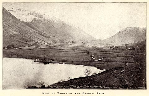 click to enlarge click to enlargeHRW302.jpg Tipped in opposite p.36 of the History and Description of the Thirlmere Water Scheme, by Sir John James Harwood. printed at bottom:- "HEAD OF THIRLMERE AND DUNMAIL RAISE" printed at lower right:- "Meisenbach" item:- Armitt Library : A660.4 Image © see bottom of page |
|||||||||||||||||||||||||
|
|
||||||||||||||||||||||||||
| evidence:- | old print:- Harwood 1895 placename:- Thirlmere |
|||||||||||||||||||||||||
| source data:- | Print, halftone photograph, View of Thirlmere, showing Ford and Celtic Bridge across
Lake, Cumberland, by Meisenbach, published by Henry Blacklock and Co, Albert Square,
Manchester, 1895.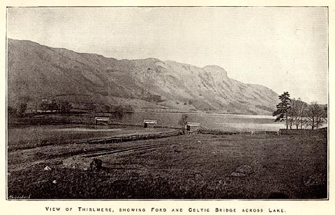 click to enlarge click to enlargeHRW303.jpg Tipped in opposite p.38 of the History and Description of the Thirlmere Water Scheme, by Sir John James Harwood. printed at bottom:- "VIEW OF THIRLMERE, SHOWING FORD AND CELTIC BRIDGE" printed at lower left:- "Meisenbach" item:- Armitt Library : A660.5 Image © see bottom of page |
|||||||||||||||||||||||||
|
|
||||||||||||||||||||||||||
| evidence:- | old print:- Harwood 1895 placename:- Thirlmere item:- rainfall; rain gauge |
|||||||||||||||||||||||||
| source data:- | Bar chart, lithograph print, rainfall at Longdendale, Lancashire and at Thirlmere,
Cumberland, 1891, published by Henry Blacklock and Co, Albert Square, Manchester,
1895.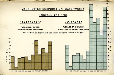 click to enlarge click to enlargeHRW305.jpg Tipped in opposite p.42 of the History and Description of the Thirlmere Water Scheme, by Sir John James Harwood. item:- Armitt Library : A660.7 Image © see bottom of page |
|||||||||||||||||||||||||
|
|
||||||||||||||||||||||||||
| evidence:- | old print:- Harwood 1895 placename:- Thirlmere item:- rainfall; rain gauge |
|||||||||||||||||||||||||
| source data:- | Bar chart, lithograph print, rainfall at Longdendale, Lancashire and at Thirlmere,
Cumberland, 1892, published by Henry Blacklock and Co, Albert Square, Manchester,
1895.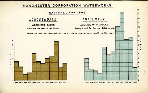 click to enlarge click to enlargeHRW306.jpg Tipped in opposite p.42 of the History and Description of the Thirlmere Water Scheme, by Sir John James Harwood. item:- Armitt Library : A660.8 Image © see bottom of page |
|||||||||||||||||||||||||
|
|
||||||||||||||||||||||||||
| evidence:- | old print:- Harwood 1895 placename:- Thirlmere item:- rainfall; rain gauge |
|||||||||||||||||||||||||
| source data:- | Bar chart, lithograph print, rainfall at Longdendale, Lancashire and at Thirlmere,
Cumberland, 1893, published by Henry Blacklock and Co, Albert Square, Manchester,
1895.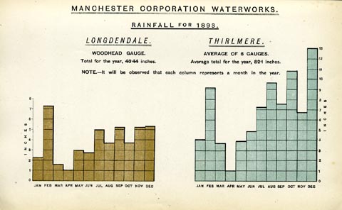 click to enlarge click to enlargeHRW307.jpg Tipped in opposite p.42 of the History and Description of the Thirlmere Water Scheme, by Sir John James Harwood. item:- Armitt Library : A660.9 Image © see bottom of page |
|||||||||||||||||||||||||
|
|
||||||||||||||||||||||||||
| evidence:- | old print:- Harwood 1895 placename:- Thirlmere |
|||||||||||||||||||||||||
| source data:- | Print, halftone photograph, Thirlmere looking North, Box Holme Island, and Raven Crag,
Cumberland, probably by Meisenbach, published by Henry Blacklock and Co, Albert Square,
Manchester, 1895.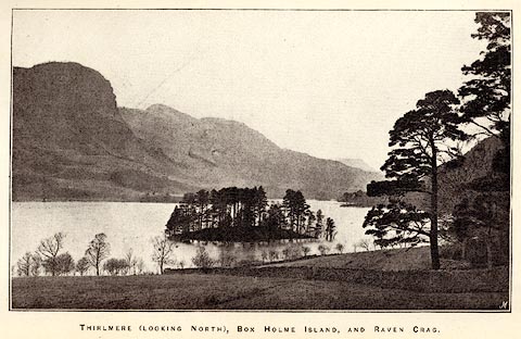 click to enlarge click to enlargeHRW309.jpg Tipped in opposite p.58 of the History and Description of the Thirlmere Water Scheme, by Sir John James Harwood. printed at bottom:- "THIRLMERE (LOOKING NORTH), BOX HOLME ISLAND, AND RAVEN CRAG." printed at lower right:- "M" item:- Armitt Library : A660.11 Image © see bottom of page |
|||||||||||||||||||||||||
|
|
||||||||||||||||||||||||||
| evidence:- | old print:- Harwood 1895 placename:- Thirlmere |
|||||||||||||||||||||||||
| source data:- | Print, halftone photograph, Thirlmere and Helvellyn from Smaithwaite, Cumberland,
probably by Meisenbach, published by Henry Blacklock and Co, Albert Square, Manchester,
1895.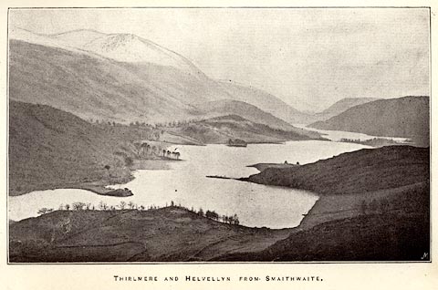 click to enlarge click to enlargeHRW310.jpg Tipped in opposite p.60 of the History and Description of the Thirlmere Water Scheme, by Sir John James Harwood. printed at bottom:- "THIRLMERE AND HELVELLYN FROM SMAITHWAITE." printed at lower right:- "M" item:- Armitt Library : A660.12 Image © see bottom of page |
|||||||||||||||||||||||||
|
|
||||||||||||||||||||||||||
| evidence:- | old print:- Harwood 1895 placename:- Thirlmere |
|||||||||||||||||||||||||
| source data:- | Print, halftone photograph, Site of Eastern Embankment, Thirlmere, Cumberland, by
Meisenbach, published by Henry Blacklock and Co, Albert Square, Manchester, 1895.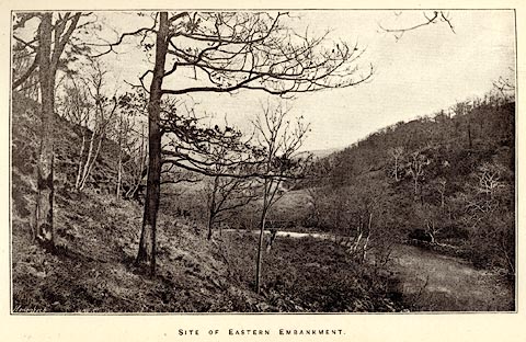 click to enlarge click to enlargeHRW311.jpg Tipped in opposite p.104 of the History and Description of the Thirlmere Water Scheme, by Sir John James Harwood. printed at bottom:- "SITE OF EASTERN EMBANKMENT." printed at lower left:- "Meisenbach" item:- Armitt Library : A660.14 Image © see bottom of page |
|||||||||||||||||||||||||
|
|
||||||||||||||||||||||||||
| evidence:- | old print:- Harwood 1895 placename:- Lake Thirlmere item:- dam |
|||||||||||||||||||||||||
| source data:- | Print, halftone photograph, Embankment at Lake Thirlmere, the dam, Thirlmere, Cumberland,
by Meisenbach, published by Henry Blacklock and Co, Albert Square, Manchester, 1895.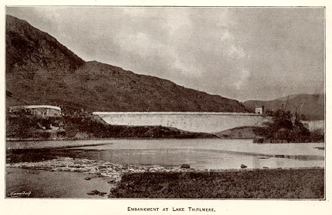 click to enlarge click to enlargeHRW313.jpg Tipped in opposite p.152 of the History and Description of the Thirlmere Water Scheme, by Sir John James Harwood. printed at bottom:- "EMBANKMENT AT LAKE THIRLMERE." printed at lower left:- "Meisenbach" item:- Armitt Library : A660.17 Image © see bottom of page |
|||||||||||||||||||||||||
|
|
||||||||||||||||||||||||||
| evidence:- | old map:- Pearson 1900s map (Thi) placename:- Thirlmere |
|||||||||||||||||||||||||
| source data:- | Map, lithograph, Round Thirlmere, Cumberland, published by C
Arthur Pearson, Henrietta Street, London, 1900s.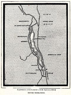 click to enlarge click to enlargePSN1M3.jpg On p.xxxii of Pearson's Gossipy Guide to the English Lakes and Neighbouring Districts. printed at bottom:- "By permission of the Controller of H.M. Stationery Office. / ROUND THIRLMERE." item:- Armitt Library : A1188.5 Image © see bottom of page |
|||||||||||||||||||||||||
|
|
||||||||||||||||||||||||||
| evidence:- | old print:- Bradley 1901 placename:- Thirlmere |
|||||||||||||||||||||||||
| source data:- | Print, uncoloured lithograph, Thirlmere, St John's Castlerigg and Wythburn, Cumberland,
by Joseph Pennell, published by Macmillan and Co, London, 1901.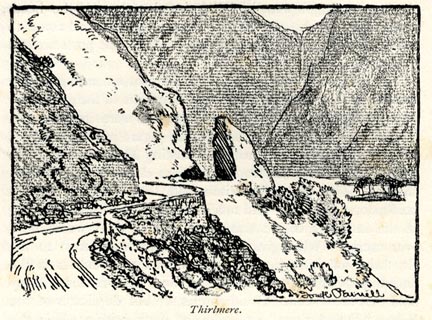 click to enlarge click to enlargeBRL162.jpg On page 242 of Highways and Byways in the Lake District, by A G Bradley. printed at lower right:- "Joseph Pennell" printed at bottom:- "Thirlmere." item:- JandMN : 464.62 Image © see bottom of page |
|||||||||||||||||||||||||
|
|
||||||||||||||||||||||||||
| evidence:- | old print:- Bradley 1901 placename:- Thirlmere |
|||||||||||||||||||||||||
| source data:- | Print, uncoloured lithograph, On Thirlmere, St John's Castlerigg and Wythburn, Cumberland,
by Joseph Pennell, published by Macmillan and Co, London, 1901.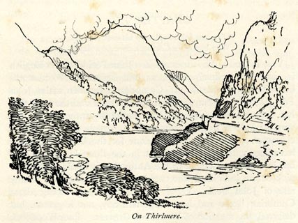 click to enlarge click to enlargeBRL164.jpg On page 247 of Highways and Byways in the Lake District, by A G Bradley. printed at bottom:- "On Thirlmere." item:- JandMN : 464.64 Image © see bottom of page |
|||||||||||||||||||||||||
|
|
||||||||||||||||||||||||||
| evidence:- | old print:- Brabant 1902 placename:- Thirlmere |
|||||||||||||||||||||||||
| source data:- | Print, uncoloured lithograph, Thirlmere and Helvellyn, St John's Castlerigg and Wythburn,
Cumberland, by Edmund H New, published by Methuen and Co, 36 Essex Street, Strand,
London, 1902.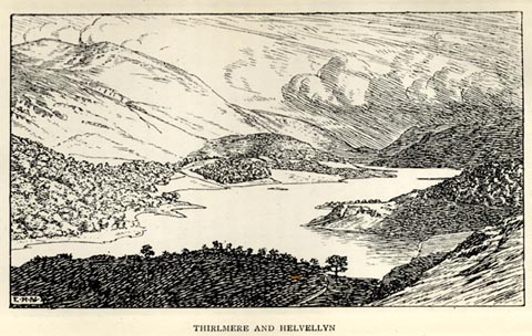 click to enlarge click to enlargeBBT107.jpg Tipped in opposite p.166 of The English Lakes, by F G Brabant. printed at bottom left:- "E. H. N" printed at bottom:- "THIRLMERE AND HELVELLYN" item:- JandMN : 502.12 Image © see bottom of page |
|||||||||||||||||||||||||
|
|
||||||||||||||||||||||||||
| evidence:- | old print:- Heaton Cooper 1905 (edn 1908) placename:- Thirlmere |
|||||||||||||||||||||||||
| source data:- | Print, colour halftone, Raven Crag, Thirlmere, St John's Castlerigg and Wythburn,
Cumberland, from a watercolour painting by Alfred Heaton Cooper, published by Adam
and Charles Black, London, 2nd edn 1908.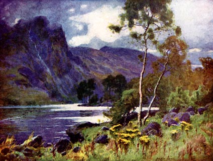 click to enlarge click to enlargeHC0157.jpg Opposite p.166 of The English Lakes, painted by Alfred Heaton Cooper, described by William T Palmer. printed at tissue opposite the print:- "RAVEN CRAG, THIRLMERE" printed at signed lower right:- "[A HEATON COOPER]" item:- JandMN : 468.57 Image © see bottom of page |
|||||||||||||||||||||||||
|
|
||||||||||||||||||||||||||
| evidence:- | old print:- Heaton Cooper 1905 (edn 1908) placename:- Thirlmere |
|||||||||||||||||||||||||
| source data:- | Print, colour halftone, Thirlmere and Helvellyn, St John's Castlerigg and Wythburn,
Cumberland, from a watercolour painting by Alfred Heaton Cooper, published by Adam
and Charles Black, London, 2nd edn 1908. click to enlarge click to enlargeHC0158.jpg Opposite p.168 of The English Lakes, painted by Alfred Heaton Cooper, described by William T Palmer. printed at tissue opposite the print:- "THIRLMERE AND HELVELLYN" printed at signed lower left:- "[A HEATON COOPER]" item:- JandMN : 468.58 Image © see bottom of page |
|||||||||||||||||||||||||
|
|
||||||||||||||||||||||||||
| evidence:- | text:- Mason 1907 (edn 1930) |
|||||||||||||||||||||||||
| source data:- | Text book, The Ambleside Geography Books bk.III, The Counties of
England, by Charlotte M Mason, published by Kegan Paul, Trench,
Trubner and Co, Broadway House, 68-74 Carter Lane, and the
Parents' Educational Union Office, 26 Victoria Street, London,
edn 1930. MSN1P021.txt Page 21:- "..." "Coming down from Helvellyn, we are again in a "smiling valley," with its beautiful lake - Thirlmere this time, water from which is brought all the way to Manchester." |
|||||||||||||||||||||||||
|
|
||||||||||||||||||||||||||
| evidence:- | old print:- Reynolds 1915 placename:- Thirlmere |
|||||||||||||||||||||||||
| source data:- | Print, colour halftone, Thirlmere and Helvellyn, Cumberland, from a painting by Alfred
Heaton Cooper, published by Adam and Charles Black, London, 1915.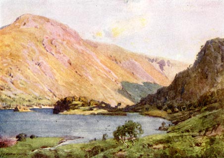 click to enlarge click to enlargeREY610.jpg "A HEATON COOPER" "THIRLMERE AND HELVELLYN" item:- JandMN : 1071.10 Image © see bottom of page |
|||||||||||||||||||||||||
|
|
||||||||||||||||||||||||||
| evidence:- | descriptive text:- Burrow 1920s placename:- Thirlmere |
|||||||||||||||||||||||||
| source data:- | Road book, strip maps with parts in Westmorland, Cumberland etc,
irregular scales about 1.5 miles to 1 inch, by E J Burrow and
Co, Cheltenham, Gloucestershire, 1920s. "... the long-shaped lake of Thirlmere, at the approach to which is Wythburn village. Close at hand on the right mighty Helvellyn ... Thirlmere now serves as a reservoir for Manchester's water supply. Our road runs close beside the lake for its entire length, ..." |
|||||||||||||||||||||||||
|
|
||||||||||||||||||||||||||
| evidence:- | old map:- Burrow 1920s |
|||||||||||||||||||||||||
| source data:- | Road book, On the Road, Dunlop Pictorial Road Plans, volume V,
strip maps with parts in Westmorland, Cumberland etc, irregular
scale about 1.5 miles to 1 inch, by E J Burrow and Co,
Cheltenham, Gloucestershire, 1920s. EJB3Vg40.jpg item:- private collection : 17 Image © see bottom of page |
|||||||||||||||||||||||||
|
|
||||||||||||||||||||||||||
| evidence:- | old photograph:- Photochrom 1930s placename:- Thirlmere |
|||||||||||||||||||||||||
| source data:- | Photograph, black and white halftone print, Thirlmere and Helvellyn, St John's Castlerigg
and Wythburn, Cumberland, published by Photochrom Co, Tunbridge Wells, Kent, 1930s?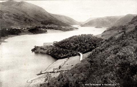 click to enlarge click to enlargePCH107.jpg printed, "Thirlmere and Helvellyn. / ..." item:- JandMN : 1015.7 Image © see bottom of page |
|||||||||||||||||||||||||
|
|
||||||||||||||||||||||||||
| evidence:- | old print:- Heywood 1906 placename:- Thirlmere |
|||||||||||||||||||||||||
| source data:- | Print, halftone, Thirlmere, St John's Castlerigg and Wythburn, Cumberland, from a
photograph by A Pettitt, Keswick, published by Abel Heywood and Son, 56-58 Oldham
Street, Manchester, and by Simpkin, Marshall, Hamilton, Kent and Co, Ave Maria Lane,
Paternoster Row, London, 1906.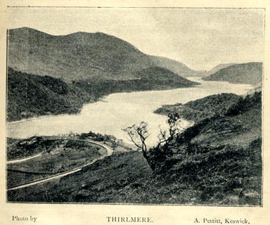 click to enlarge click to enlargeHW1E15.jpg In a Guide to Keswick and its Vicinity in the Penny Guide Books series. printed at bottom:- "Photo by / THIRLMERE. / A. Pettitt, Keswick." item:- JandMN : 348.15 Image © see bottom of page |
|||||||||||||||||||||||||
|
|
||||||||||||||||||||||||||
| evidence:- | old print:- placename:- Thirlmere |
|||||||||||||||||||||||||
| source data:- | Print, chromolithograph, Thirlmere, Cumberland, published by T Nelson and Sons, London,
1900s?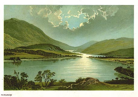 click to enlarge click to enlargePR0164.jpg From a set of prints, The Scenery of the English Lakes printed at lower right:- "T. NELSON &SONS" printed at bottom left:- "THIRLMERE" item:- Dove Cottage : 2008.107.164 Image © see bottom of page |
|||||||||||||||||||||||||
|
|
||||||||||||||||||||||||||
| evidence:- | old print:- Prior 1865 placename:- Thirl Mere |
|||||||||||||||||||||||||
| source data:- | Print, uncoloured engraving, Thirl Mere and Saddleback, from Helvellyn, Cumberland,
published by John Garnett, Windermere, Westmorland, and by Simpkin, Marshall and Co,
London, 1865.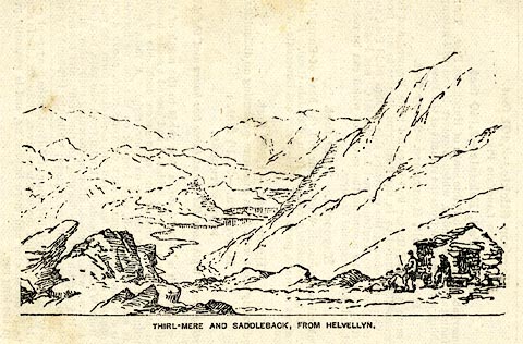 click to enlarge click to enlargePI0117.jpg Included on page 130 of the guide book, Ascents and Passes in the Lake District of England, by Herman Prior. printed at bottom:- "THIRL-MERE AND SADDLEBACK, FROM HELVELLYN." item:- JandMN : 235.19 Image © see bottom of page |
|||||||||||||||||||||||||
|
|
||||||||||||||||||||||||||
| evidence:- | old print:- Religious Tract Society 1860s placename:- Thirlmere |
|||||||||||||||||||||||||
| source data:- | Print, engraving, View from the North West of Thirlmere, with Helvellyn on the Left,
Cumberland, published by the Religious Tract Society, London, 1860s?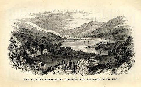 click to enlarge click to enlargeRL01E4.jpg Tipped in opp.p.52 in How To See the English Lakes. printed at bottom:- "VIEW FROM THE NORTH-WEST OF THIRLMERE, WITH HELVELLYN ON THE LEFT." item:- Armitt Library : A1150.5 Image © see bottom of page |
|||||||||||||||||||||||||
|
|
||||||||||||||||||||||||||
| evidence:- | old print:- Nelson 1859 placename:- Thirlmere |
|||||||||||||||||||||||||
| source data:- | Print, engraving, Thirlemere from the Road to Keswick from Ambleside, drawn by Keeley
Halswelle, Edinburgh, published by T Nelson and Sons, Paternoster Row, London, and
Edinburgh and New York, United States, 1859.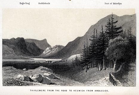 click to enlarge click to enlargeNS0111.jpg Tipped in oppposite p.270 of a guide book, The English Lakes. printed at bottom:- "THIRLEMERE FROM THE ROAD TO KESWICK FROM AMBLESIDE." item:- JandMN : 336.10 Image © see bottom of page |
|||||||||||||||||||||||||
|
|
||||||||||||||||||||||||||
| evidence:- | outline view:- Martineau 1855 placename:- Thirlmere |
|||||||||||||||||||||||||
| source data:- | Print, engraving, outline view, Mountains seen from the West Side of Thirlmere, drawn
by L Aspland, engraved by W Banks, Edinburgh, published by John Garnett, Windermere,
Westmorland, and by Whittaker and Co, London, 1855.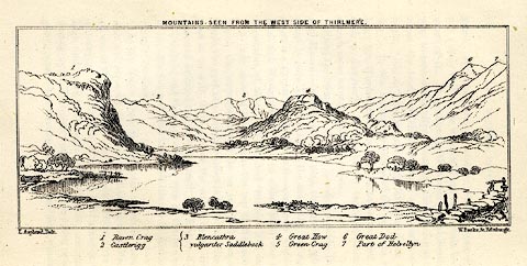 click to enlarge click to enlargeMNU110.jpg Opposite p.69 in A Complete Guide to the English Lakes, by Harriet Martineau. The view is captioned, numbers refering to mountains in the image - 1 Raven Crag, 2 Castlerigg, 3 Blancathra vulgariter Saddleback, 4 Great How, 5 Green Crag, 6, Great Dod, 7 Part of Helvellyn. printed at top:- "MOUNTAINS SEEN FROM THE WEST SIDE OF THIRLMERE." printed at bottom left, right:- "L Aspland Delt. / W Banks Sc Edinr." item:- Armitt Library : A1159.10 Image © see bottom of page |
|||||||||||||||||||||||||
|
|
||||||||||||||||||||||||||
| evidence:- | old print:- Pyne 1853 placename:- Thirlemere |
|||||||||||||||||||||||||
| source data:- | Drawn by James Barker Pyne, 1848-1853, lithographed by T Picken, 1859.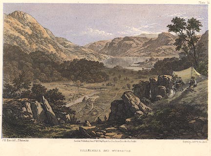 click to enlarge click to enlargePY12.jpg "Thirlemere and Wytheburn" item:- JandMN : 97.12 Image © see bottom of page |
|||||||||||||||||||||||||
|
|
||||||||||||||||||||||||||
| evidence:- | old print:- Garnett 1850s-60s F placename:- Thrilmere |
|||||||||||||||||||||||||
| source data:- | Print, uncoloured engraving, Thrilmere from Raven Crag, ie Thirlemere, Cumberland,
engraved by Banks and Co, Edinburgh, probably published by John Garnett, Windermere,
Westmorland, 1850s-60s?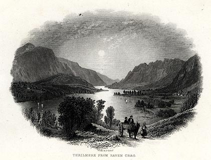 click to enlarge click to enlargeGAR727.jpg Found with Views of the English Lakes. printed at bottom:- "Banks &Co, Edinr. / THRILMERE FROM RAVEN CRAG." item:- JandMN : 165.27 Image © see bottom of page |
|||||||||||||||||||||||||
|
|
||||||||||||||||||||||||||
| evidence:- | old print:- Garnett 1850s-60s F placename:- Leaths Water |
|||||||||||||||||||||||||
| source data:- | Print, uncoloured engraving, Leaths Water ie Thirlmere, Cumberland, drawn and engraved
by William Banks and Son, Edinburgh, published by John Garnett, Windermere, Westmorland,
1850s-60s?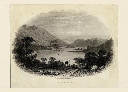 click to enlarge click to enlargeGAR719.jpg Found with Views of the English Lakes. printed at bottom:- "Drawn & Engd. by W. Banks &Son, Edinr. / LEATHS WATER." item:- JandMN : 165.19 Image © see bottom of page |
|||||||||||||||||||||||||
|
|
||||||||||||||||||||||||||
| evidence:- | old print:- Rose 1832-35 (vol.1 no.36) placename:- Thirlmere placename:- Wythburn Water |
|||||||||||||||||||||||||
| source data:- | Print, uncoloured engraving, Thirlmere, or Wythburn Water, Cumberland, drawn by G
Pickering, engraved by W le Petit, published by Fisher, Son and Co, London, 1833.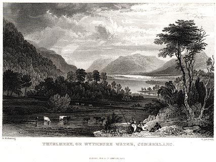 click to enlarge click to enlargePR0012.jpg vol.1 pl.36 in the set of prints, Westmorland, Cumberland, Durham and Northumberland Illustrated. A fishing party in the foreground. printed at bottom left, right, centre:- "G. Pickering. / W. Le Petit. / THIRLMERE, OR WYTHBURN WATER, CUMBERLAND. / FISHER, SON &CO. LONDON, 1833." item:- Dove Cottage : 2008.107.12 Image © see bottom of page |
|||||||||||||||||||||||||
|
|
||||||||||||||||||||||||||
| evidence:- | old print:- Rose 1832-35 |
|||||||||||||||||||||||||
| source data:- | Print, engraving, Thirlmere Bridge, Looking North, Cumberland, by Thomas Allom, engraved
by W le Petit, 1833.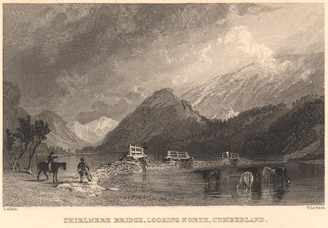 click to enlarge click to enlargeR241.jpg "Thirlmere Bridge, Looking North, Cumberland" item:- JandMN : 96.14 Image © see bottom of page |
|||||||||||||||||||||||||
|
|
||||||||||||||||||||||||||
| evidence:- | old print:- Green 1819 placename:- Leaths Water |
|||||||||||||||||||||||||
| source data:- | Print, aquatint, Leaths Water from Bucks Holm, ie Thirlmere, Cumberland, by William
Green, 1819, published by R Lough and Co, Chronicle Office, Finkle Street, Kendal,
and others, 1820.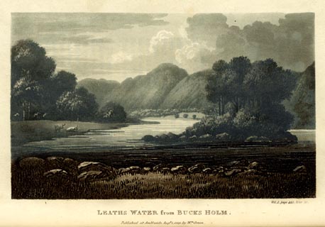 click to enlarge click to enlargeGN0116.jpg Tipped in opposite vol.1 p.441 of The Tourist's New Guide, by William Green. printed at bottom right, centre:- "Vol.I, page 441, line 20. / LEATHS WATER from BUCKS HOLM. / Published at Ambleside, Augt. 1. 1819, by Wm. Green." item:- Armitt Library : A1141.17 Image © see bottom of page |
|||||||||||||||||||||||||
|
|
||||||||||||||||||||||||||
| evidence:- | old print:- Green 1819 placename:- Leaths Water |
|||||||||||||||||||||||||
| source data:- | Print, aquatint, Leaths Water, ie Thirlmere, Cumberland, by William Green, 1819, published
by R Lough and Co, Chronicle Office, Finkle Street, Kendal, and others, 1820.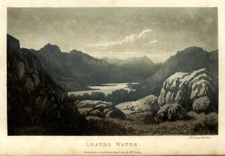 click to enlarge click to enlargeGN0115.jpg Tipped in opposite vol.1 p.427 of The Tourist's New Guide, by William Green. printed at bottom right, centre:- "Vol.I, page 427, line 1. / LEATHS WATER. / Published at Ambleside, Augt. 1. 1819, by Wm. Green." item:- Armitt Library : A1141.16 Image © see bottom of page |
|||||||||||||||||||||||||
|
|
||||||||||||||||||||||||||
| evidence:- | old print:- Gresham Publishing 1900s placename:- Thirlmere |
|||||||||||||||||||||||||
| source data:- | Print, colour halftone, Thirlmere and Helvellyn, Cumberland, by Ernest W Haslehurst,
published by The Gresham Publishing Co, 66 Chandos Street, London, 1900s?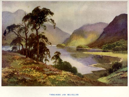 click to enlarge click to enlargePR1563.jpg Tipped in opposite p.20 of The English Lakes section of a volume of Our Beautiful Homeland. printed at bottom:- "THIRLMERE AND HELVELLYN" printed at lower right:- "E. W. HASLEHURST" item:- JandMN : 381.5 Image © see bottom of page |
|||||||||||||||||||||||||
|
|
||||||||||||||||||||||||||
| evidence:- | old painting:- placename:- Thirlmere |
|||||||||||||||||||||||||
| source data:- | Painting, watercolour, Head of Thirlmere, Cumberland, by Frederick Clive Newcome,
1880-94.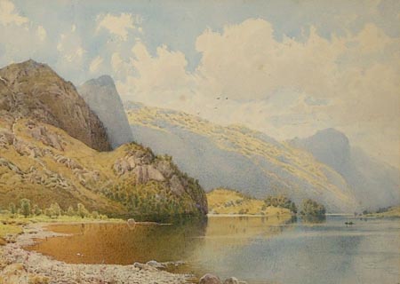 click to enlarge click to enlargePR1305.jpg Sunny day; view of Thirlmere from its stony foreshore; the fells descend to the water's edge, crossing composition diagonally, and are reflected in the still waters. Tiny rowing boat to far right. signed at bottom right:- "NEWCOME" inscribed at reverse:- "Head of Thirlmere" item:- Tullie House Museum : 1980.22 Image © Tullie House Museum |
|||||||||||||||||||||||||
|
|
||||||||||||||||||||||||||
| evidence:- | old print:- Pearson 1900s placename:- Thirlmere |
|||||||||||||||||||||||||
| source data:- | Print, halftone photograph, Thirlmere from Dunmail Raise, Cumberland, published by
C Arthur Pearson, Henrietta Street, London, 1900s. click to enlarge click to enlargePS1E13.jpg On p.24 of Pearson's Gossipy Guide to the English Lakes and Neighbouring Districts. printed at bottom:- "THIRLMERE, FROM DUNMAIL RAISE. (p.143)." item:- Armitt Library : A1188.20 Image © see bottom of page |
|||||||||||||||||||||||||
|
|
||||||||||||||||||||||||||
| evidence:- | old print:- Pearson 1900s placename:- Thirlmere |
|||||||||||||||||||||||||
| source data:- | Print, halftone photograph, Thirlmere from the South, Cumberland, published by C Arthur
Pearson, Henrietta Street, London, 1900s.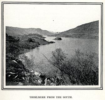 click to enlarge click to enlargePS1E15.jpg On p.29 of Pearson's Gossipy Guide to the English Lakes and Neighbouring Districts. printed at bottom:- "THIRLMERE FROM THE SOUTH." item:- Armitt Library : A1188.22 Image © see bottom of page |
|||||||||||||||||||||||||
|
|
||||||||||||||||||||||||||
| evidence:- | old print:- Pearson 1900s placename:- Thirlmere |
|||||||||||||||||||||||||
| source data:- | Print, halftone photograph, Thirlmere, from the South, St John's Castlerigg and Wythburn,
Cumberland, published by C Arthur Pearson, Henrietta Street, London, 1900s.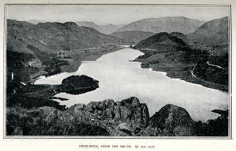 click to enlarge click to enlargePS1E68.jpg On p.193 of Pearson's Gossipy Guide to the English Lakes and Neighbouring Districts. printed at bottom:- "THIRLMERE, FROM THE SOUTH. (p.191, 192)." item:- Armitt Library : A1188.75 Image © see bottom of page |
|||||||||||||||||||||||||
|
|
||||||||||||||||||||||||||
| evidence:- | old print:- Sylvan 1847 placename:- Leathe's Water |
|||||||||||||||||||||||||
| source data:- | Print, engraving, Leathes' Water from the West, ie Thirlmere, Cumberland, published
by John Johnstone, Paternoster Row, London, et al, 1847.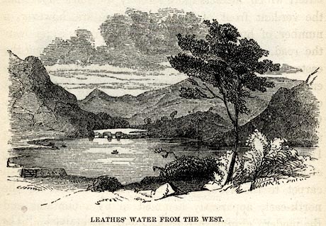 click to enlarge click to enlargeSYL139.jpg On p.154 of Sylvan's Pictorial Guide to the English Lakes. printed at bottom:- "LEATHES' WATER FROM THE WEST." item:- Armitt Library : A1201.39 Image © see bottom of page |
|||||||||||||||||||||||||
|
|
||||||||||||||||||||||||||
| evidence:- | outline view:- Tattersall 1836 (version 1869) placename:- Thirlmere |
|||||||||||||||||||||||||
| source data:- | Print, hand coloured, Thirlmere, from the North, Cumberland, drawn by George Tattersall,
1836, engraved by W F Topham, published by T J Allman, 463 Oxford Street, London,
1869.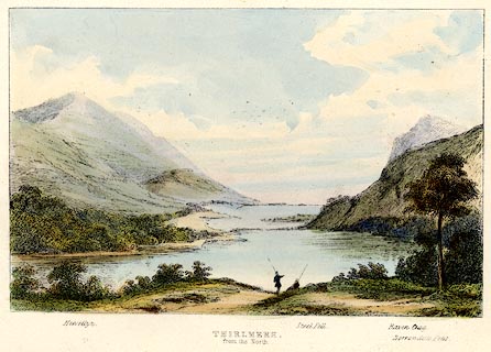 click to enlarge click to enlargeTAT207.jpg Included in The Lakes of England, by W F Topham. printed at bottom:- "THIRLMERE, / from the North." printed at bottom:- "Helvellyn. / Steel Fell. / Raven Crag. / Borrowdale Fells." item:- Armitt Library : A1067.7 Image © see bottom of page |
|||||||||||||||||||||||||
|
|
||||||||||||||||||||||||||
| evidence:- | outline view:- Tattersall 1836 placename:- Thirlmere |
|||||||||||||||||||||||||
| source data:- | Print, engraving, Thirlmere, from the North, Cumberland, drawn by George Tattersall,
engraved by W F Topham, published by Sherwood and Co, Paternoster Row, London, about
1836.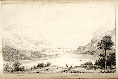 click to enlarge click to enlargeTAT118.jpg The print is captioned with mountain names and acts as an outline view. Tipped in opposite p.55 of The Lakes of England, by George Tattersall. printed at bottom:- "THIRLMERE, / from the North." printed at bottom left to right:- "Helvellyn. / Steel Fell. / Raven Crag. / Borrowdale Fells." item:- Armitt Library : A1204.19 Image © see bottom of page |
|||||||||||||||||||||||||
|
|
||||||||||||||||||||||||||
| evidence:- | outline view:- Tattersall 1836 placename:- Thirlmere |
|||||||||||||||||||||||||
| source data:- | Print, engraving, Thirlmere from Raysgap, Cumberland, drawn by George Tattersall,
engraved by W F Topham, published by Sherwood and Co, Paternoster Row, London, about
1836.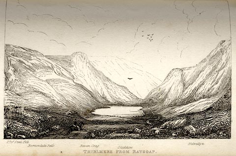 click to enlarge click to enlargeTAT117.jpg The print is captioned with mountain names and acts as an outline view. Tipped in opposite p.54 of The Lakes of England, by George Tattersall. printed at bottom:- "THIRLMERE FROM RAYSGAP." printed at bottom left to right:- "Pt. of Steel Fell. / Borrowdale Fells. / Raven Crag. / Skiddaw. / Helvellyn." item:- Armitt Library : A1204.18 Image © see bottom of page |
|||||||||||||||||||||||||
|
|
||||||||||||||||||||||||||
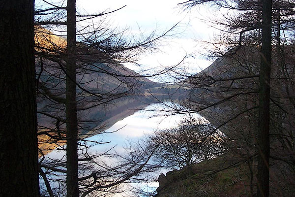 BLM61.jpg Looking south to Dunmail Raise. (taken 25.12.2005) 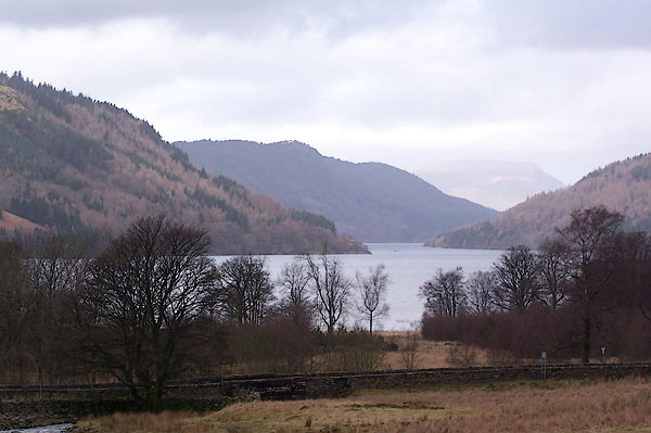 BLQ05.jpg From the south. (taken 15.2.2006)  BSX53.jpg Wyth Burn running in at the S end, after a dry Spring. (taken 27.6.2010)  Click to enlarge BND86.jpg Mountains on the east of the lake. (taken 5.2.2007)  BNE01.jpg From above Castle Rock. (taken 5.2.2007) 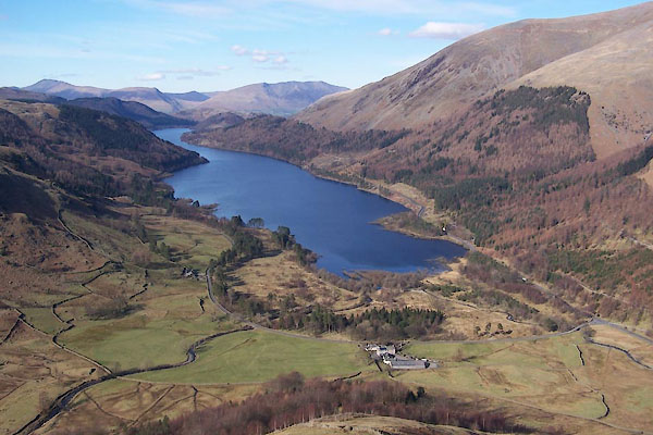 BUF82.jpg From above West Head Farm. (taken 14.3.2011) 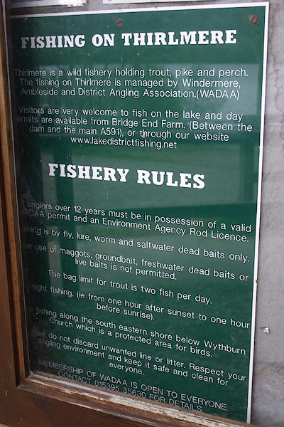 BYI43.jpg Fishing rules, at Armboth. (taken 21.5.2013) |
||||||||||||||||||||||||||
|
|
||||||||||||||||||||||||||
 CCU69.jpg Wheelbarrow used in the reservoir construction work. (displayed at Wythburn Chapel) (taken 10.4.2015) |
||||||||||||||||||||||||||
|
|
||||||||||||||||||||||||||
| hearsay:- |
There were two small lakes; Leathes Water to the north, Wythburn Water to the south.
These became one when Thirlmere reservoir was created, raising the water level 54
feet. The hamlets of Armboth and Wythburn were flooded. |
|||||||||||||||||||||||||
| The dam wall is 260 yards long, 100 feet high. |
||||||||||||||||||||||||||
| John Ruskin and Thomas Carlyle were involved in the resistance to the project, and
though this failed the issue was one of the seeds that fruited as the National Trust
in 1895. Ruskin described Manchester Corporation:- |
||||||||||||||||||||||||||
| "as a coporate body, plotting at last to steal, and sell, for a profit, the waters
of Thirlmere and the clouds of Helvellyn ... [they] should be put at the bottom of
the Lake of Thirlmere ..." |
||||||||||||||||||||||||||
|
|
||||||||||||||||||||||||||
| :- |
An plot of the old and new lakes, overlain, is given by John Parker in his Atlas of
the English Lakes. |
|||||||||||||||||||||||||
| Parker 2002 |
||||||||||||||||||||||||||
|
|
||||||||||||||||||||||||||
| :- |
Top water level 179 metres above Newlyn datum |
|||||||||||||||||||||||||
|
|
||||||||||||||||||||||||||
| see:- | viewpoint, Dalehead Hall Thomas West |
|||||||||||||||||||||||||
|
|
||||||||||||||||||||||||||
Lakes Guides menu.