 Old Cumbria Gazetteer
 |
 |
|
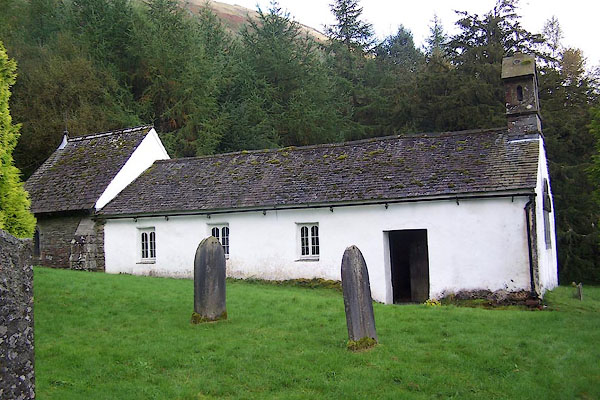
| Wythburn Chapel, Wythburn | ||
| Wythburn Chapel | ||
| locality:- | Wythburn | |
| civil parish:- | St John's Castlerigg and Wythburn (formerly Cumberland) | |
| county:- | Cumbria | |
| locality type:- | church | |
| locality type:- | chapel | |
| coordinates:- | NY32431358 | |
| 1Km square:- | NY3213 | |
| 10Km square:- | NY31 | |
|
|
||
 BJX81.jpg (taken 8.10.2005) 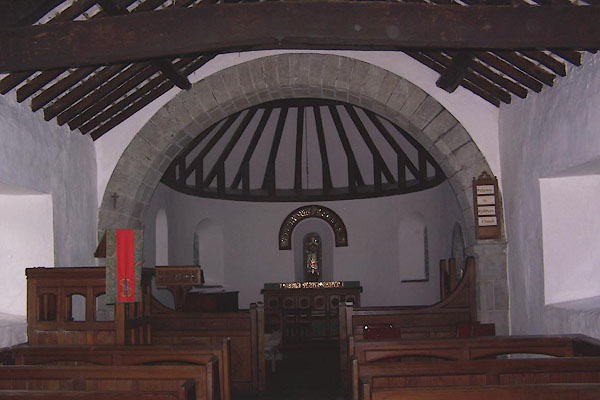 BJX82.jpg (taken 8.10.2005) |
||
|
|
||
| evidence:- | old map:- Ogilby 1675 (plate 96) placename:- Wyborn Chapel |
|
| source data:- | Road strip map, hand coloured engraving, the Road from Kendal to
Cockermouth, and the Road from Egremond to Carlisle, scale about
1 inch to 1 mile, by John Ogilby, London, 1675.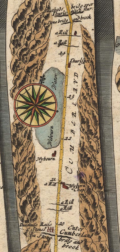 OG96m020.jpg In mile 20, Cumberland. "Wyborn Chap:" church on the right of the road. item:- JandMN : 22 Image © see bottom of page |
|
|
|
||
| evidence:- | old map:- Berry 1679 placename:- Wiburn Chapel |
|
| source data:- | Road map, diagram, The Grand Roads of England, engraved by John
Rich, made and published by William Berry, at the Sign of the
Globe, London, 1679. "Wiburn~ Chapel" |
|
|
|
||
| evidence:- | old map:- Bowen 1720 (plate 260) placename:- Wibourn Chappel |
|
| source data:- | Road strip map, uncoloured engraving, pl.260, The Road from
Kendal to Cockermouth, scale about 2 miles to 1 inch, with
sections in Westmorland and Cumberland, published by Emanuel
Bowen, St Katherines, London, 1720.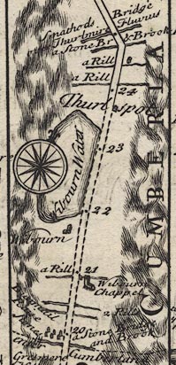 B260m20.jpg At mile 21. item:- private collection : 1.260 Image © see bottom of page |
|
|
|
||
| evidence:- | old map:- Bowen and Kitchin 1760 placename:- Wiborn Church |
|
| source data:- | Map, hand coloured engraving, A New Map of the Counties of
Cumberland and Westmoreland Divided into their Respective Wards,
scale about 4 miles to 1 inch, by Emanuel Bowen and Thomas
Kitchin et al, published by T Bowles, Robert Sayer, and John
Bowles, London, 1760.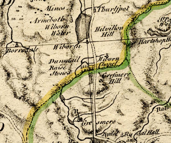 BO18NY20.jpg "Wiborn Church" circle and line item:- Armitt Library : 2008.14.10 Image © see bottom of page |
|
|
|
||
| evidence:- | old map:- Donald 1774 (Cmd) |
|
| source data:- | Map, hand coloured engraving, 3x2 sheets, The County of Cumberland, scale about 1
inch to 1 mile, by Thomas Donald, engraved and published by Joseph Hodskinson, 29
Arundel Street, Strand, London, 1774.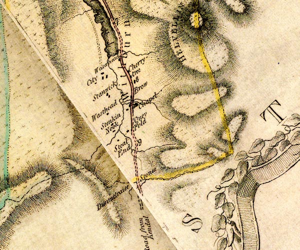 D4NY31SW.jpg "Chapel" church item:- Carlisle Library : Map 2 Image © Carlisle Library |
|
|
|
||
| evidence:- | descriptive text:- West 1778 (11th edn 1821) |
|
| source data:- | Guide book, A Guide to the Lakes, by Thomas West, published by
William Pennington, Kendal, Cumbria once Westmorland, and in
London, 1778 to 1821. goto source goto sourceAddendum; Mr Gray's Journal, 1769 Page 210:- "..." "Oct. 8. I left Keswick, and took the Ambleside road, ..." "Next I passed by the little chapel of Wythburn, out of which the Sunday congregation were then issuing: ..." |
|
|
|
||
| evidence:- | old text:- Clarke 1787 placename:- Wytheburn Chapel |
|
| source data:- | Guide book, A Survey of the Lakes of Cumberland, Westmorland,
and Lancashire, written and published by James Clarke, Penrith,
Cumberland, and in London etc, 1787; published 1787-93. goto source Page 118:- "..." "Wytheburn chapel is a perpetual curacy under Crossthwaite, the ancient salary two pounds ten shillings; certified to the governors of Queen Anne's bounty at three pounds six shillings and fourpence, worth now thirty-one pounds a year. The chapel is a very poor low building, and not consecrated; their burying place is Crossthwaite." |
|
|
|
||
| evidence:- | old map:- Clarke 1787 map (Ambleside to Keswick) |
|
| source data:- | Map, A Map of the Roads Lakes etc between Keswick and Ambleside,
scale about 2.5 ins to 1 mile, by James Clarke, engraved by S J
Neele, 352 Strand, published by James Clarke, Penrith,
Cumberland and in London etc, 1787. CL9NY31B.jpg "Chapel" item:- private collection : 10.9 Image © see bottom of page |
|
|
|
||
| evidence:- | road book:- Cary 1798 (2nd edn 1802) placename:- Wythburn Chapel |
|
| source data:- | Road book, itineraries, Cary's New Itinerary, by John Cary, 181
Strand, London, 2nd edn 1802. goto source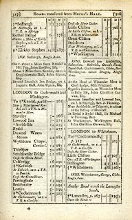 click to enlarge click to enlargeC38317.jpg page 317-318 "Wythburn Chapel" item:- JandMN : 228.1 Image © see bottom of page |
|
|
|
||
| evidence:- | old text:- Gents Mag |
|
| source data:- | Magazine, The Gentleman's Magazine or Monthly Intelligencer or
Historical Chronicle, published by Edward Cave under the
pseudonym Sylvanus Urban, and by other publishers, London,
monthly from 1731 to 1922. goto source Gentleman's Magazine 1805 p.1011 "... we passed the little modest chapel of Wythburn, noticed by Mr. Gray. The antient salary of its Curate, we were credibly informed, amounted to 2l. 10s. per annum! ..." |
|
|
|
||
| evidence:- | old map:- Laurie and Whittle 1806 placename:- Wytheburn Chapel |
|
| source data:- | Road map, Completion of the Roads to the Lakes, scale about 10
miles to 1 inch, by Nathaniel Coltman? 1806, published by Robert
H Laurie, 53 Fleet Street, London, 1834. click to enlarge click to enlargeLw18.jpg "Wytheburn Chapel 285¾" church; distance from London item:- private collection : 18.18 Image © see bottom of page |
|
|
|
||
| evidence:- | descriptive text:- Otley 1823 (5th edn 1834) |
|
| source data:- | Guide book, A Concise Description of the English Lakes, the
mountains in their vicinity, and the roads by which they may be
visited, with remarks on the mineralogy and geology of the
district, by Jonathan Otley, published by the author, Keswick,
Cumberland now Cumbria, by J Richardson, London, and by Arthur
Foster, Kirkby Lonsdale, Cumbria, 1823; published 1823-49,
latterly as the Descriptive Guide to the English Lakes. goto source Page 110:- "... the road passes between the Inn and the Chapel of Wythburn; about eight miles and a half from Ambleside, and the same distance from Keswick. ..." |
|
|
|
||
| evidence:- | descriptive text:- Ford 1839 (3rd edn 1843) |
|
| source data:- | Guide book, A Description of Scenery in the Lake District, by
Rev William Ford, published by Charles Thurnam, Carlisle, by W
Edwards, 12 Ave Maria Lane, Charles Tilt, Fleet Street, William
Smith, 113 Fleet Street, London, by Currie and Bowman,
Newcastle, by Bancks and Co, Manchester, by Oliver and Boyd,
Edinburgh, and by Sinclair, Dumfries, 1839. goto source Page 45:- "..." "... Whilst the luncheon is preparing [at the Horse Head Inn], let the tourist take a look at the little chapel on the opposite side of the road; it is an advanced post of Crosthwaite Church, and is one of five similarly situated. The building does not claim much attention, being small, yet commodious; but unfortunately for the dalesmen, the chapel-yard is unconsecrated, and thus one source of useful and heart-softening reflections, arising from the sight of their relations' graves, is closed to them." |
|
|
|
||
| evidence:- | old drawing:- Aspland 1840s-60s placename:- Wythburn Chapel |
|
| source data:- | Drawing, pencil, Wythburn Chapel, Wythburn, Cumberland, by Theophilus Lindsey Aspland,
1853.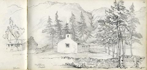 click to enlarge click to enlargeAS0381.jpg "Wythburn / Chapel" page number "64" item:- Armitt Library : 1958.390.81 Image © see bottom of page |
|
|
|
||
| evidence:- | old map:- Garnett 1850s-60s H |
|
| source data:- | Map of the English Lakes, in Cumberland, Westmorland and
Lancashire, scale about 3.5 miles to 1 inch, published by John
Garnett, Windermere, Westmorland, 1850s-60s. GAR2NY31.jpg cross, a church item:- JandMN : 82.1 Image © see bottom of page |
|
|
|
||
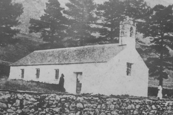
| evidence:- | old photograph:- Bell 1880s-1940s |
|
| source data:- | Photograph, black and white, Wythburn Chapel, Wythburn, St John's Castlerigg and Wythburn,
Cumberland, by Herbert Bell, photographer, Ambleside, Westmorland, 1890s.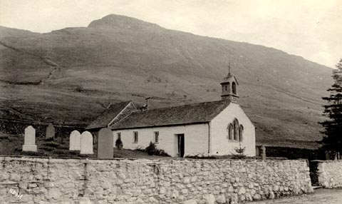 click to enlarge click to enlargeHB0842.jpg internegative at lower left:- "H. Bell" item:- Armitt Library : ALPS505 Image © see bottom of page |
|
|
|
||
| evidence:- | old map:- Nurse 1918 |
|
| source data:- | Map, The Diocese of Carlisle, Cumberland, Westmorland, and
Lancashire North of the Sands, scale about 4 miles to 1 inch, by
Rev Euston J Nurse, published by Charles Thurnam and Sons, 11
English Street, Carlisle, Cumberland, 2nd edn 1939. NUR1NY31.jpg "WYTHBURN" United benefice with St John's in the Vale, but separate parish. item:- JandMN : 27 Image © see bottom of page |
|
|
|
||
 notes about bells. notes about bells. |
||
|
|
||
| stained glass |
||
|
|
||
| evidence:- | database:- Listed Buildings 2010 placename:- Wythburn Church |
|
| source data:- | courtesy of English Heritage "WYTHBURN CHURCH / / / ST JOHNS CASTLERIGG AND WYTHBURN / ALLERDALE / CUMBRIA / II / 72191 / NY3243813578" |
|
| source data:- | courtesy of English Heritage "Parish church. 1640 on the site of an earlier chapel, with restoration of 1740 and 1872 addition. Painted rendered walls on projecting plinth stones, with slate rubble additions, all under graduated greenslate roofs. 3-bay nave with west open bellcote and slightly higher apse of 1872 and south vestry. C20 studded plank door and C20 2-light casement windows, all within plain reveals. Triple lancet west window. Narrow round-headed windows in vestry and apse. Interior has open timber roof on C17 trusses. Stained glass in west window 1888; that in apse by Henry Holiday, 1892 and Hugh Arnold, 1906. Late C19 furnishing and fittings." |
|
|
|
||
| evidence:- | old print:- Pearson 1900s |
|
| source data:- | Print, halftone photograph, Wythburn's Modest House of Prayer, Wythburn Chapel, St
John's Castlerigg and Wythburn, Cumberland, published by C Arthur Pearson, Henrietta
Street, London, 1900s.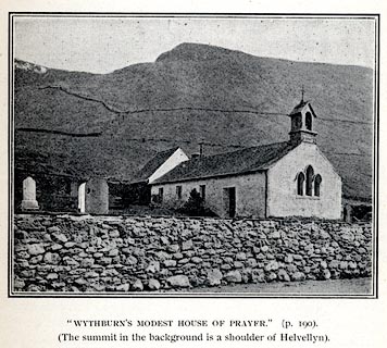 click to enlarge click to enlargePS1E67.jpg On p.191 of Pearson's Gossipy Guide to the English Lakes and Neighbouring Districts. printed at bottom:- "'WYTHBURN'S MODEST HOUSE OF PRAYER.' (p.190). / (The summit in the background is the shoulder of Helvellyn)." item:- Armitt Library : A1188.74 Image © see bottom of page |
|
|
|
||
| evidence:- | old print:- Bogg 1898 placename:- Wythburn Chapel |
|
| source data:- | Print, engraving, Wythburn Chapel, St John's Castlerigg and Wythburn, Cumberland,
by A Haselgrave, 1897, published by Edmund Bogg, 3 Woodhouse Lane, and James Miles,
Guildford Street, Leeds, Yorkshire, 1898.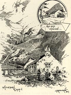 click to enlarge click to enlargeBGG158.jpg Included on p.171 of Lakeland and Ribblesdale, by Edmund Bogg. item:- JandMN : 231.58 Image © see bottom of page |
|
|
|
||
| evidence:- | old print:- Goodwin 1887 (edn 1890) |
|
| source data:- | Print, etching? Wytheburn, the chapel, Cumberland, by Harry Goodwin, published by
Swan Sonnenschein and Co, Paternoster Square, London, 1890.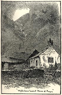 click to enlarge click to enlargePR1615.jpg Tipped in opposite p.220 of Through the Wordsworth Country, by William Knight. printed at lower centre:- ""Wytheburns modest House of Prayer"" item:- JandMN : 382.45 Image © see bottom of page |
|
|
|
||
 CCU71.jpg About 1870. 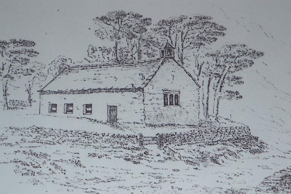 CCU72.jpg About 1750. |
||
|
|
||
| notes:- |
There has been a church here since 1554. The present nave dates to 1740, incorporating
some parts dating back to 1640. The chancel and small vestry were added in 1872. It
was re-roofed after a third of the slates were stolen in 1993. Once a chapel of ease
to Crosthwaite, Keswick, it became a parish in 1862? |
|
| Darrall, Geoffrey: 2006: Wythburn Church and the Valley of Thirlmere: Piper Publications
(Keswick, Cumbria) |
||
|
|
||
| hearsay:- |
Parson Sewell from Troutbeck was preaching here but lost his sermon between the pulpit
and the wall:- |
|
| "T' sarmonts slipt down t' neuk and ah can't git it out, but sitha ah'll read ye a
chapter o' t' Bible worth ten on it." |
||
|
|
||
| hearsay:- |
William Wordsworth, The Waggoner:- |
|
| "Wythburn's modest house of prayer, / as lowly as the lowliest dwelling, ..." |
||
|
|
||
Lakes Guides menu.