 Old Cumbria Gazetteer
 |
 |
|
||||||||||||||||||||||||
| Fairfield, Lakes | ||||||||||||||||||||||||||
| Fairfield | ||||||||||||||||||||||||||
| civil parish:- | Lakes (formerly Westmorland) | |||||||||||||||||||||||||
| civil parish:- | Patterdale (formerly Westmorland) | |||||||||||||||||||||||||
| county:- | Cumbria | |||||||||||||||||||||||||
| locality type:- | hill | |||||||||||||||||||||||||
| coordinates:- | NY35871176 | |||||||||||||||||||||||||
| 1Km square:- | NY3511 | |||||||||||||||||||||||||
| 10Km square:- | NY31 | |||||||||||||||||||||||||
| altitude:- | 2864 feet | |||||||||||||||||||||||||
| altitude:- | 873m | |||||||||||||||||||||||||
|
|
||||||||||||||||||||||||||
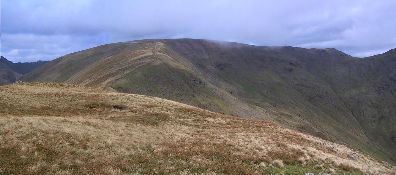
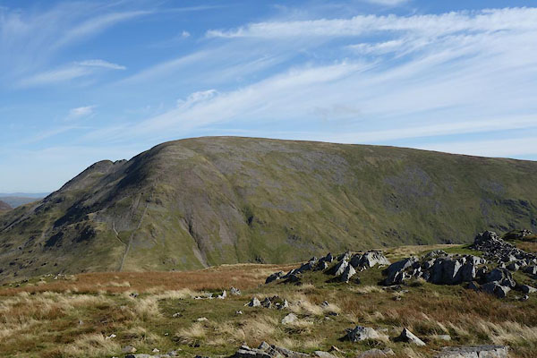 CDZ97.jpg From W. (taken 28.9.2015) 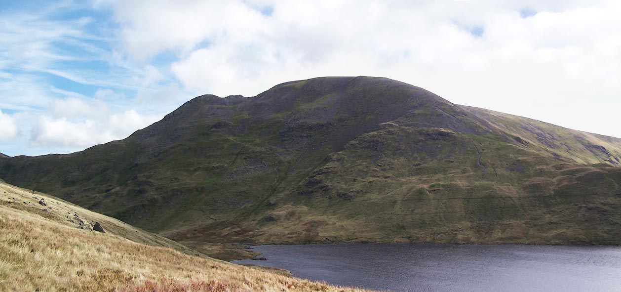 Click to enlarge BVL38.jpg (taken 26.9.2011) |
||||||||||||||||||||||||||
|
|
||||||||||||||||||||||||||
| evidence:- | old map:- OS County Series (Wmd 19 5) placename:- Fairfield |
|||||||||||||||||||||||||
| source data:- | Maps, County Series maps of Great Britain, scales 6 and 25
inches to 1 mile, published by the Ordnance Survey, Southampton,
Hampshire, from about 1863 to 1948. |
|||||||||||||||||||||||||
|
|
||||||||||||||||||||||||||
| evidence:- | old map:- Jefferys 1770 (Wmd) |
|||||||||||||||||||||||||
| source data:- | Map, 4 sheets, The County of Westmoreland, scale 1 inch to 1
mile, surveyed 1768, and engraved and published by Thomas
Jefferys, London, 1770.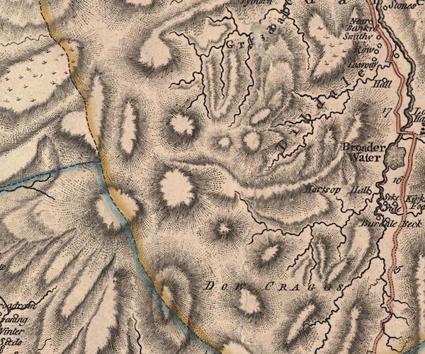 J5NY31SE.jpg hill hachuring; hill or mountain item:- National Library of Scotland : EME.s.47 Image © National Library of Scotland |
|||||||||||||||||||||||||
|
|
||||||||||||||||||||||||||
| evidence:- | descriptive text:- West 1778 (11th edn 1821) |
|||||||||||||||||||||||||
| source data:- | Print, hand coloured engraving, Grasmere, Lakes, Westmorland,
drawn by I Feary, engraved by Robert Havell and Son. goto source goto sourceFrontispiece 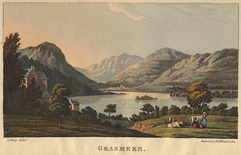 click to enlarge click to enlargeWS21F.jpg "I. Feary delint. / Engraved by Robt. Havell &Son. / GRASMERE." The hills appear to be Helm Crag on the left; the road to Keswick going up to Dunmail Raise; then Seat Sandal and the Helvellyn Range which in reality would only be visible from an elevated position; Great Rigg leading up to Fairfield; and part of Rydal fell to the right. item:- Armitt Library : A1221.2 Image © see bottom of page |
|||||||||||||||||||||||||
|
|
||||||||||||||||||||||||||
| evidence:- | old map:- Clarke 1787 map (Ambleside to Keswick) placename:- Fair Field Mount |
|||||||||||||||||||||||||
| source data:- | Map, A Map of the Roads Lakes etc between Keswick and Ambleside,
scale about 2.5 ins to 1 mile, by James Clarke, engraved by S J
Neele, 352 Strand, published by James Clarke, Penrith,
Cumberland and in London etc, 1787.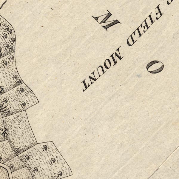 CL9NY30P.jpg "FAIR FIELD MOUNT" item:- private collection : 10.9 Image © see bottom of page |
|||||||||||||||||||||||||
|
|
||||||||||||||||||||||||||
| evidence:- | old map:- Otley 1818 placename:- Fairfield |
|||||||||||||||||||||||||
| source data:- | Map, uncoloured engraving, The District of the Lakes,
Cumberland, Westmorland, and Lancashire, scale about 4 miles to
1 inch, by Jonathan Otley, 1818, engraved by J and G Menzies,
Edinburgh, Scotland, published by Jonathan Otley, Keswick,
Cumberland, et al, 1833.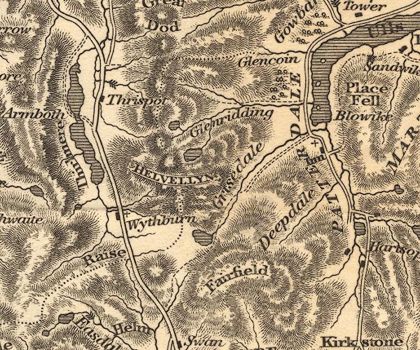 OT02NY31.jpg item:- JandMN : 48.1 Image © see bottom of page |
|||||||||||||||||||||||||
|
|
||||||||||||||||||||||||||
| evidence:- | outline view:- Otley 1823 (8th edn 1849) placename:- Fairfield |
|||||||||||||||||||||||||
| source data:- | Engraving, outline view of mountains, Windermere looking towards the North East from
Bowness, drawn by T Binns, engraved by O Jewitt, opposite p.2 of A Descriptive Guide
of the English Lakes, by Jonathan Otley, 8th edition, 1849.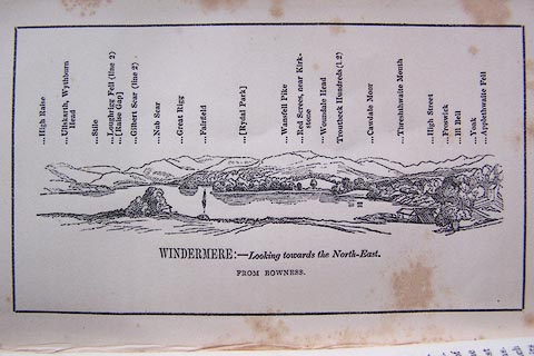 click to enlarge click to enlargeO80E02.jpg With a list of mountains. item:- Armitt Library : A1180.3 Image © see bottom of page |
|||||||||||||||||||||||||
|
|
||||||||||||||||||||||||||
| evidence:- | outline view:- Otley 1823 (8th edn 1849) placename:- Fairfield |
|||||||||||||||||||||||||
| source data:- | Engraving, outline view of mountains, Grasmere from Red Bank Head, drawn by T Binns,
engraved by O Jewitt, opposite p.4 of A Descriptive Guide of the English Lakes, by
Jonathan Otley, 8th edition, 1849.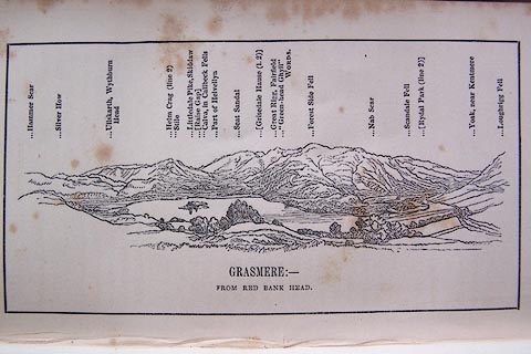 click to enlarge click to enlargeO80E04.jpg item:- Armitt Library : A1180.5 Image © see bottom of page |
|||||||||||||||||||||||||
|
|
||||||||||||||||||||||||||
| evidence:- | outline view:- Otley 1823 (5th edn 1834) |
|||||||||||||||||||||||||
| source data:- | Print, woodcut outline view, The Mountains of Grasmere and
Rydal, by Jonathan Otley, Keswick, Cumberland, 1830.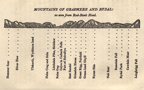 click to enlarge click to enlargeOT2E03.jpg Printed on p.15 of A Concise Description of the English Lakes, by Jonathan Otley, 5th edition, 1834. "MOUNTAINS OF GRASMERE AND RYDAL: as seen from Red-Bank Head." "Hammer Scar / Silver How / Ullskarth, Wythburn head / Helm Crag and Stile / Littledale Pike, Skiddaw / Raise Gap / Calva in Caldbeck Fells / Part of Helvellyn / Seat Sandal / Grisedale Hause / Great Rigg, Fairfield / Green-head Ghyll / Forest Side / Nab Scar / Scandale Fell / Rydal Park / Cawdale Moor / Loughrigg Fell" item:- JandMN : 48.4 Image © see bottom of page |
|||||||||||||||||||||||||
|
|
||||||||||||||||||||||||||
| evidence:- | outline view:- Otley 1823 (5th edn 1834) |
|||||||||||||||||||||||||
| source data:- | Print, woodcut outline view, Mountains North East of Windermere, by Jonathan Otley,
Keswick, Cumberland, 1830.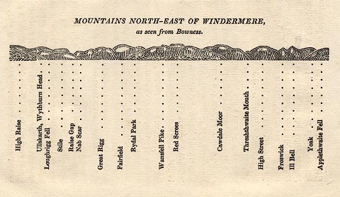 click to enlarge click to enlargeOT2E11.jpg Printed on p.99 of A Concise Description of the English Lakes, by Jonathan Otley, 5th edition, 1834. "MOUNTAINS NORTH-EAST OF WINDERMERE, as seen from Bowness." Mountains are listed:- "High Raise / Ullskarth, Wythburn Head / Loughrigg Fell / Stile / Raise Gap / Nab Scar / Great Rigg / Fairfield / Rydal Park / Wansfell Pike / Red Screes / Cawdale Moor / Threshthwaite Mouth / High Street / Froswick / Ill Bell / Yoak / Applethwaite Fell" item:- JandMN : 48.12 Image © see bottom of page |
|||||||||||||||||||||||||
|
|
||||||||||||||||||||||||||
| evidence:- | descriptive text:- Otley 1823 (5th edn 1834) |
|||||||||||||||||||||||||
| source data:- | Guide book, A Concise Description of the English Lakes, the
mountains in their vicinity, and the roads by which they may be
visited, with remarks on the mineralogy and geology of the
district, by Jonathan Otley, published by the author, Keswick,
Cumberland now Cumbria, by J Richardson, London, and by Arthur
Foster, Kirkby Lonsdale, Cumbria, 1823; published 1823-49,
latterly as the Descriptive Guide to the English Lakes. goto source Page 72:- "FAIRFIELD" "- 2950 feet above the level of the sea - makes a fine mountain excursion from Ambleside, commencing the ascent at Rydal, encircling Rydal head, and" goto sourcePage 74:- "returning to Ambleside by Nook End. Lakes and Tarns to the number of ten, may be enumerated in this excursion; viz. Ullswater, Windermere, Esthwaite, Coniston, Grasmere, and Rydal lakes; and Elterwater, Blelham, Easdale, and Grisedale tarns: oftener than once, may eight of them be reckoned from one station. Here is likewise a good view of the different creeks and inlets of the sea towards Lancaster and Ulverston." |
|||||||||||||||||||||||||
|
|
||||||||||||||||||||||||||
| evidence:- | descriptive text:- Ford 1839 (3rd edn 1843) placename:- Fairfield item:- altitude, Fairfield |
|||||||||||||||||||||||||
| source data:- | Guide book, A Description of Scenery in the Lake District, by
Rev William Ford, published by Charles Thurnam, Carlisle, by W
Edwards, 12 Ave Maria Lane, Charles Tilt, Fleet Street, William
Smith, 113 Fleet Street, London, by Currie and Bowman,
Newcastle, by Bancks and Co, Manchester, by Oliver and Boyd,
Edinburgh, and by Sinclair, Dumfries, 1839. goto source "... THE Lake district ... consists of large masses or clusters of mountains, generally terminating in one aspiring and pre-eminent point, with the intermediate valleys occupied either by lakes and their subsidiary tarns, or by winding rivers." "The chief nuclei of these clusters are, Skiddaw and Blencathra, Helvellyn, Fairfield, Coniston Old Man, Blackcomb, Scafell, Gable, Red Pike, Grasmoor, Grisdale Pike, and the Langdale Pikes. Many noble and commanding mountains rise around these, rivalling them in height and grandeur, but still" goto sourcePage iv:- "serving as large buttresses only. In the presentation of endlessly-diversified forms, these Mountains yield to none, however individually inferior they may be, owing to their being seldom seen in a detached point of view; although, on the other hand, they have thus the advantage of forming combinations at once grand and sublime, towering above each other, or rising in ridges, like the mighty billows of the ocean." goto sourcePage 34:- "..." "FAIRFIELD." "The attainment of the top of this mountain presents a lengthened excursion, attended with more of enterprise and fatigue; it is two thousand nine hundred and fifty feet above the level of the sea, closing on the north the Rydal domain, whence it should be ascended, in a course directed on the left to Nab Scar. In a circular round from this point, Windermere, Blelham Tarn, Esthwaite Water, Coniston, Elter Water, Rydal Water, Grasmere," goto sourcePage 35:- "and Easedale Tarn, the river Rothay in all its windings, Morecambe Bay, Milnthorpe Sands, and the Yorkshire mountains; and, lastly, the mountains about Eskdale, Borrodale, Wastdale, and Ennerdale, are visible. From the highest point, Graysdale Tarn and Ulles Water, Penrith, and Crossfell, are discernible; and three is a grand rocky view into Deepdale and Hartshope successively." goto sourcePage 178:- "ELEVATION OF THE MOUNTAINS," "ACCORDING TO DIFFERENT AUTHORITIES."
|
|||||||||||||||||||||||||
|
|
||||||||||||||||||||||||||
| evidence:- | old map:- Garnett 1850s-60s H placename:- Fairfield |
|||||||||||||||||||||||||
| source data:- | Map of the English Lakes, in Cumberland, Westmorland and
Lancashire, scale about 3.5 miles to 1 inch, published by John
Garnett, Windermere, Westmorland, 1850s-60s. GAR2NY31.jpg "Fairfield" hill hachuring item:- JandMN : 82.1 Image © see bottom of page |
|||||||||||||||||||||||||
|
|
||||||||||||||||||||||||||
| evidence:- | old text:- Martineau 1855 |
|||||||||||||||||||||||||
| source data:- | Guide book, A Complete Guide to the English Lakes, by Harriet
Martineau, published by John Garnett, Windermere, Westmorland,
and by Whittaker and Co, London, 1855; published 1855-76. goto source Page 45:- "... Rothay Bridge, whence there is a fine view of the valley, with the cul-de-sac of Fairfield closing it in to the north. Whether the vapours are gathering and tumbling in that basin,- the recess of Fairfield,- or whether every projection, streak, slide, and mossy tract is clearly visible, that northern barrier is very imposing; and perhaps most so to those who are most familiar with it, and can read its manifold weather signs and tokens. ..." "..." goto sourcePage 58:- "... Fairfield? That excursion is safe, not over fatiguing, practicable for a summer day, and presenting scenery as characteristic as can be found. Let it be Fairfield." "..." |
|||||||||||||||||||||||||
|
|
||||||||||||||||||||||||||
| evidence:- | outline view:- Martineau 1855 |
|||||||||||||||||||||||||
| source data:- | Print, engraving, outline view, Mountains seen on the Keswick Road approaching Ullswater,
drawn by L Aspland, engraved by W Banks, Edinburgh, published by John Garnett, Windermere,
Westmorland, and by Whittaker and Co, London, 1855.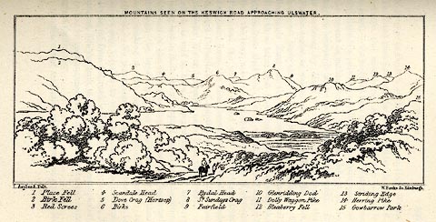 click to enlarge click to enlargeMNU115.jpg Opposite p.104 in A Complete Guide to the English Lakes, by Harriet Martineau. "MOUNTAINS SEEN ON THE KESWICK ROAD APPROACHING ULLSWATER." "L Aspland Delt. / W Banks Sc Edinr." The view is captioned, numbers referring to mountains in the image:- "1 Place Fell, 2 Birk Fell, 3 Red Screes, 4 Scandale Head, 5 Dove Crag (Hartsop), 6 Birks, 7 Rydal Head, 8 St. Sundays Crag, 9, Fairfield, 10 Glenridding Dod, 11 Dolly Waggon Pike, 12 Bleaberry Fell, 13 Striding Edge, 14 Herring Pike, 15 Gowbarrow Park." item:- Armitt Library : A1159.15 Image © see bottom of page |
|||||||||||||||||||||||||
|
|
||||||||||||||||||||||||||
| evidence:- | old text:- Martineau 1855 item:- altitude, Fairfield |
|||||||||||||||||||||||||
| source data:- | Guide book, A Complete Guide to the English Lakes, by Harriet
Martineau, published by John Garnett, Windermere, Westmorland,
and by Whittaker and Co, London, 1855; published 1855-76. goto source Page 179:- "A TABLE OF THE HEIGHTS OF MOUNTAINS IN THE COUNTIES OF CUMBERLAND, WESTMORLAND, AND LANCASHIRE." "No. : Names of Mountains. : Counties. : Height in Feet above the Sea Level." "5 : Fairfield : Westmorland : 2950" |
|||||||||||||||||||||||||
|
|
||||||||||||||||||||||||||
| evidence:- | old photograph:- Bell 1880s-1940s |
|||||||||||||||||||||||||
| source data:- | Photograph, sepia, Fairfiled from Loughrigg, Westmorland, by Herbert Bell, photographer,
Ambleside, Westmorland, 1890s. click to enlarge click to enlargeHB0866.jpg item:- Armitt Library : ALPS537 Image © see bottom of page |
|||||||||||||||||||||||||
|
|
||||||||||||||||||||||||||
| evidence:- | old photograph:- Bell 1880s-1940s |
|||||||||||||||||||||||||
| source data:- | Photograph, sepia, Fairfield from Loughrigg, Westmorland, by Herbert Bell, photographer,
Ambleside, Westmorland, 1890s. click to enlarge click to enlargeHB0847.jpg internegative at lower right:- "H. Bell" item:- Armitt Library : ALPS517 Image © see bottom of page |
|||||||||||||||||||||||||
|
|
||||||||||||||||||||||||||
| evidence:- | old photograph:- Bell 1880s-1940s |
|||||||||||||||||||||||||
| source data:- | Photograph, black and white, Fairfield from Loughrigg, Westmorland, by Herbert Bell,
photographer, Ambleside, Westmorland, 1890s. click to enlarge click to enlargeHB0846.jpg item:- Armitt Library : ALPS514 Image © see bottom of page |
|||||||||||||||||||||||||
|
|
||||||||||||||||||||||||||
| evidence:- | old photograph:- Bell 1880s-1940s |
|||||||||||||||||||||||||
| source data:- | Photograph, sepia, Fairfield, and Grisedale Tarn, Patterdale, Westmorland, by Herbert
Bell, photographer, Ambleside, Westmorland, 1890s. click to enlarge click to enlargeHB0567.jpg internegative at lower left:- "H. Bell" item:- Armitt Library : ALPS227 Image © see bottom of page |
|||||||||||||||||||||||||
|
|
||||||||||||||||||||||||||
| evidence:- | old photograph:- Bell 1880s-1940s |
|||||||||||||||||||||||||
| source data:- | Photograph, b/w, Rydal from Brow Head, Westmorland, by Herbert Bell, Ambleside, Westmorland,
1890s? click to enlarge click to enlargeHB0278.jpg item:- Armitt Library : ALPS635 Image © see bottom of page |
|||||||||||||||||||||||||
|
|
||||||||||||||||||||||||||
| evidence:- | old photograph:- Bell 1880s-1940s |
|||||||||||||||||||||||||
| source data:- | Photograph, black and white, Fairfield, from Loughrigg, by Herbert Bell, Ambleside,
Westmorland, 1890s. click to enlarge click to enlargeHB0194.jpg item:- Armitt Library : ALPS9 Image © see bottom of page |
|||||||||||||||||||||||||
|
|
||||||||||||||||||||||||||
| evidence:- | old photograph:- Bell 1880s-1940s |
|||||||||||||||||||||||||
| source data:- | Photograph, sepia, Fairfiled from Loughrigg, Westmorland, by Herbert Bell, photographer,
Ambleside, Westmorland, 1890s. click to enlarge HB0866.jpg item:- Armitt Library : ALPS537 Image © see bottom of page |
|||||||||||||||||||||||||
|
|
||||||||||||||||||||||||||
| evidence:- | old photograph:- Bell 1880s-1940s |
|||||||||||||||||||||||||
| source data:- | Photograph, sepia, Fairfield from Loughrigg, Westmorland, by Herbert Bell, photographer,
Ambleside, Westmorland, 1890s. click to enlarge HB0847.jpg internegative at lower right:- "H. Bell" item:- Armitt Library : ALPS517 Image © see bottom of page |
|||||||||||||||||||||||||
|
|
||||||||||||||||||||||||||
| evidence:- | old photograph:- Bell 1880s-1940s |
|||||||||||||||||||||||||
| source data:- | Photograph, black and white, Fairfield from Loughrigg, Westmorland, by Herbert Bell,
photographer, Ambleside, Westmorland, 1890s. click to enlarge HB0846.jpg item:- Armitt Library : ALPS514 Image © see bottom of page |
|||||||||||||||||||||||||
|
|
||||||||||||||||||||||||||
| evidence:- | old photograph:- Bell 1880s-1940s |
|||||||||||||||||||||||||
| source data:- | Photograph, sepia, Fairfield, and Grisedale Tarn, Patterdale, Westmorland, by Herbert
Bell, photographer, Ambleside, Westmorland, 1890s. click to enlarge HB0567.jpg internegative at lower left:- "H. Bell" item:- Armitt Library : ALPS227 Image © see bottom of page |
|||||||||||||||||||||||||
|
|
||||||||||||||||||||||||||
| evidence:- | old photograph:- Bell 1880s-1940s |
|||||||||||||||||||||||||
| source data:- | Photograph, b/w, Rydal from Brow Head, Westmorland, by Herbert Bell, Ambleside, Westmorland,
1890s? click to enlarge HB0278.jpg item:- Armitt Library : ALPS635 Image © see bottom of page |
|||||||||||||||||||||||||
|
|
||||||||||||||||||||||||||
| evidence:- | old photograph:- Bell 1880s-1940s |
|||||||||||||||||||||||||
| source data:- | Photograph, black and white, Fairfield, from Loughrigg, by Herbert Bell, Ambleside,
Westmorland, 1890s. click to enlarge HB0194.jpg item:- Armitt Library : ALPS9 Image © see bottom of page |
|||||||||||||||||||||||||
|
|
||||||||||||||||||||||||||
| evidence:- | old map:- Postlethwaite 1877 (3rd edn 1913) placename:- Fairfield |
|||||||||||||||||||||||||
| source data:- | Map, uncoloured engraving, Map of the Lake District Mining Field, Westmorland, Cumberland,
Lancashire, scale about 5 miles to 1 inch, by John Postlethwaite, published by W H
Moss and Sons, 13 Lowther Street, Whitehaven, Cumberland, 1877 edn 1913.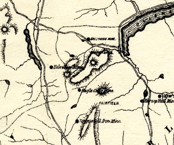 PST2NY31.jpg "FAIRFIELD" hill hachuring item:- JandMN : 162.2 Image © see bottom of page |
|||||||||||||||||||||||||
|
|
||||||||||||||||||||||||||
| evidence:- | outline view:- Jenkinson 1875 placename:- Fairfield |
|||||||||||||||||||||||||
| source data:- | Print, lithograph, outline view, Panoramic Sketches from Helvellyn, Westmorland, by
Edwin A Pettitt, London, published by Edward Stanford, 55 Charing Cross, London, 1875. click to enlarge click to enlargeJk01E1.jpg "... Fairfield ..." item:- JandMN : 28.5 Image © see bottom of page |
|||||||||||||||||||||||||
|
|
||||||||||||||||||||||||||
| evidence:- | outline view:- Matthew 1866 placename:- Fairfield |
|||||||||||||||||||||||||
| source data:- | Print, engraving, outline view, Helvellyn from above Harrop Tarn, Poney Road from
Wythburn to Whatendlath and Borrowdale, Cumberland, published by J Richardson, Highgate,
Kendal, Westmorland, 1866.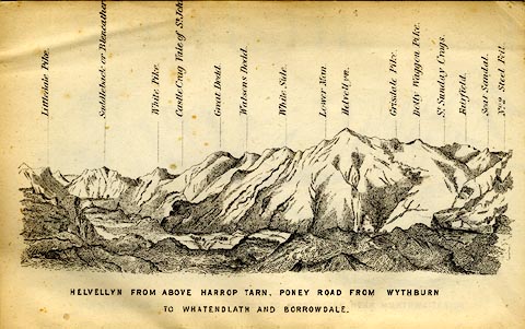 click to enlarge click to enlargeMW1E02.jpg Tipped in before p.1 of The English Lakes, Peaks and Passes, from Kendal to Keswick, by George King Matthew. printed at bottom:- "HELVELLYN FROM ABOVE HARROP TARN, PONEY ROAD FROM WYTHBURN TO WHATENDLATH AND BORROWDALE." printed at caption to mountains:- "... Fairfield. ..." item:- Armitt Library : A1168.2 Image © see bottom of page |
|||||||||||||||||||||||||
|
|
||||||||||||||||||||||||||
| evidence:- | outline view:- Black 1856 (23rd edn 1900) placename:- Fairfield |
|||||||||||||||||||||||||
| source data:- | Print, lithograph, Outline Views, Ullswater - Mountains as seen a little on the Matterdale
Road near Lyulph's Tower on Ullswater, and Mountains as seen at the Slate Quarry at
Blowick on Ullswater, by J Flintoft, Keswick, Cumberland, engraved by R Mason, Edinburgh,
Lothian, about 1900.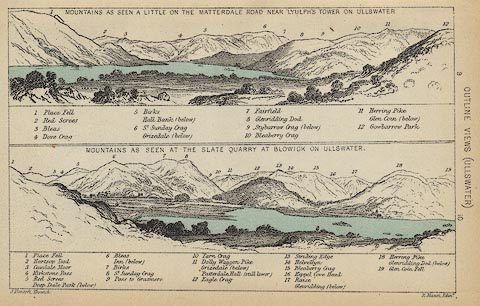 click to enlarge click to enlargeBC08E2.jpg "... 7 Fairfield ..." item:- JandMN : 37.8 Image © see bottom of page |
|||||||||||||||||||||||||
|
|
||||||||||||||||||||||||||
| evidence:- | outline view:- Black 1856 (23rd edn 1900) placename:- Fairfield |
|||||||||||||||||||||||||
| source data:- | Print, lithograph, Outline Views, Windermere - Mountains as seen from the North End
of Belle Isle, Windermere, and Mountains as seen from Biscay How, Bowness, by J Flintoft,
Keswick, Cumberland, engraved by R Mason, Edinburgh, Lothian, about 1900.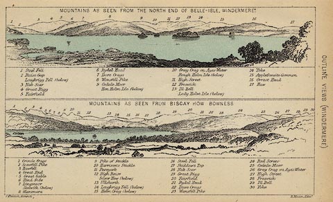 click to enlarge click to enlargeBC08E1.jpg "... 5 Fairfield ... 20 Fairfield ..." item:- JandMN : 37.4 Image © see bottom of page |
|||||||||||||||||||||||||
|
|
||||||||||||||||||||||||||
| evidence:- | outline view:- Black 1841 (3rd edn 1846) placename:- Fairfield |
|||||||||||||||||||||||||
| source data:- | Print, engraving, outline view, Mountains as seen from the North End of Belle Isle,
Windermere, and Mountains as seen from Bisket How, Bowness, by J Flintoft, Keswick,
Cumberland, engraved by R Mason, Edinburgh, about 1844.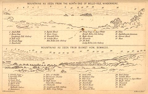 click to enlarge click to enlargeBC02E1.jpg "... 5 Fairfield ... 20 Fairfield ..." item:- JandMN : 32.3 Image © see bottom of page |
|||||||||||||||||||||||||
|
|
||||||||||||||||||||||||||
| evidence:- | outline view:- Black 1841 (3rd edn 1846) placename:- Fairfield |
|||||||||||||||||||||||||
| source data:- | Print, engraving, outline view, Mountains as seen a little on the Matterdale Road
near Lyulph's Tower on Ulleswater, and Mountains as seen at the Slate Quarry at Blowick
on Ulleswater, by J Flintoft, Keswick, Cumberland, engraved by R Mason, Edinburgh,
Lothian, about 1846.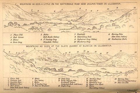 click to enlarge click to enlargeBC02E9.jpg "... 7 Fairfield ..." item:- JandMN : 32.15 Image © see bottom of page |
|||||||||||||||||||||||||
|
|
||||||||||||||||||||||||||
| evidence:- | outline view:- Tattersall 1836 placename:- Fairfield |
|||||||||||||||||||||||||
| source data:- | Print, engraving, Windermere from Rayrigg Bank, Westmorland, drawn by George Tattersall,
engraved by W F Topham, published by Sherwood and Co, Paternoster Row, London, about
1836.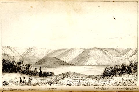 click to enlarge click to enlargeTAT104.jpg The print is captioned with mountain names and acts as an outline view. Tipped in opposite p.31 of The Lakes of England, by George Tattersall. printed at bottom:- "WINDERMERE from RAYRIGG BANK." printed at bottom left to right:- "Furness Fells. / Coniston Old Man. / Wetherlam Foot. / Wrynose. / Langdale Pikes. / Hardknot. / Loughrigg Fell. / Fairfield. / Troutbeck Hundred. / Kirkstone. / Wansfell. / Applethwaite Common. / High Street. / Hill Bell." item:- Armitt Library : A1204.5 Image © see bottom of page |
|||||||||||||||||||||||||
|
|
||||||||||||||||||||||||||
| evidence:- | outline view:- Tattersall 1836 placename:- Fairfield item:- boat; rowing boat |
|||||||||||||||||||||||||
| source data:- | Print, engraving, Upper Reach, Windermere, Westmorland, drawn by George Tattersall,
engraved by W F Topham, published by Sherwood and Co, Paternoster Row, London, about
1836.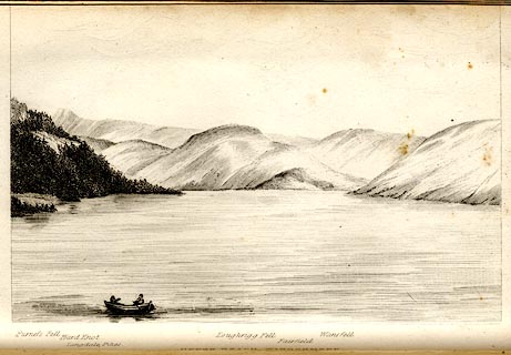 click to enlarge click to enlargeTAT102.jpg The print is captioned with mountain names and acts as an outline view. Tipped in opposite p.25 of The Lakes of England, by George Tattersall. printed at bottom:- "UPPER REACH, WINDERMERE." printed at bottom left to right:- "Furness Fell. / Hard Knot. / Langdale Pikes. / Loughrigg Fell. / Fairfield. / Wansfell." item:- Armitt Library : A1204.3 Image © see bottom of page |
|||||||||||||||||||||||||
|
|
||||||||||||||||||||||||||
| evidence:- | outline view:- placename:- Fairfield |
|||||||||||||||||||||||||
| source data:- | Print, hand coloured engraving, Lower Reach, Ullswater from Pooley Bridge, Westmorland
and Cumberland, published by Sherwood and Co, London, 1836?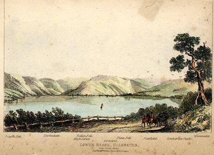 click to enlarge click to enlargePR0371.jpg Objects in the view are identified by a caption at the bottom - Swarth Fell, Martindale, High Street, Hallen Fell, Kirkstone, Place Fell, Fairfield, Gowbarrow Parks, Dumallet. printed at bottom:- "LOWER REACH, ULLSWATER. / from Pooley Bridge. / Pubd. April 15th 1836 by Sherwood &Co London." item:- Dove Cottage : 2008.107.371 Image © see bottom of page |
|||||||||||||||||||||||||
|
|
||||||||||||||||||||||||||
| evidence:- | old drawing:- placename:- Fairfield |
|||||||||||||||||||||||||
| source data:- | Drawing, ink, Fairfield, from the Meadow, at Fox How? Rydal, Westmorland, by Jane
Arnold, no date.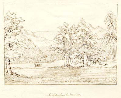 click to enlarge click to enlargePR1874.jpg "Fairfield, from the Meadow." item:- Armitt Library : 1958.3774.3 Image © see bottom of page |
|||||||||||||||||||||||||
|
|
||||||||||||||||||||||||||
 ascent 1855 ascent 1855 |
||||||||||||||||||||||||||
|
|
||||||||||||||||||||||||||
 Click to enlarge BRS39.jpg (taken 7.10.2009) |
||||||||||||||||||||||||||
|
|
||||||||||||||||||||||||||
Lakes Guides menu.