 Speed 1611

|

|
|
|
map type:- Speed 1611 |
|
|
|
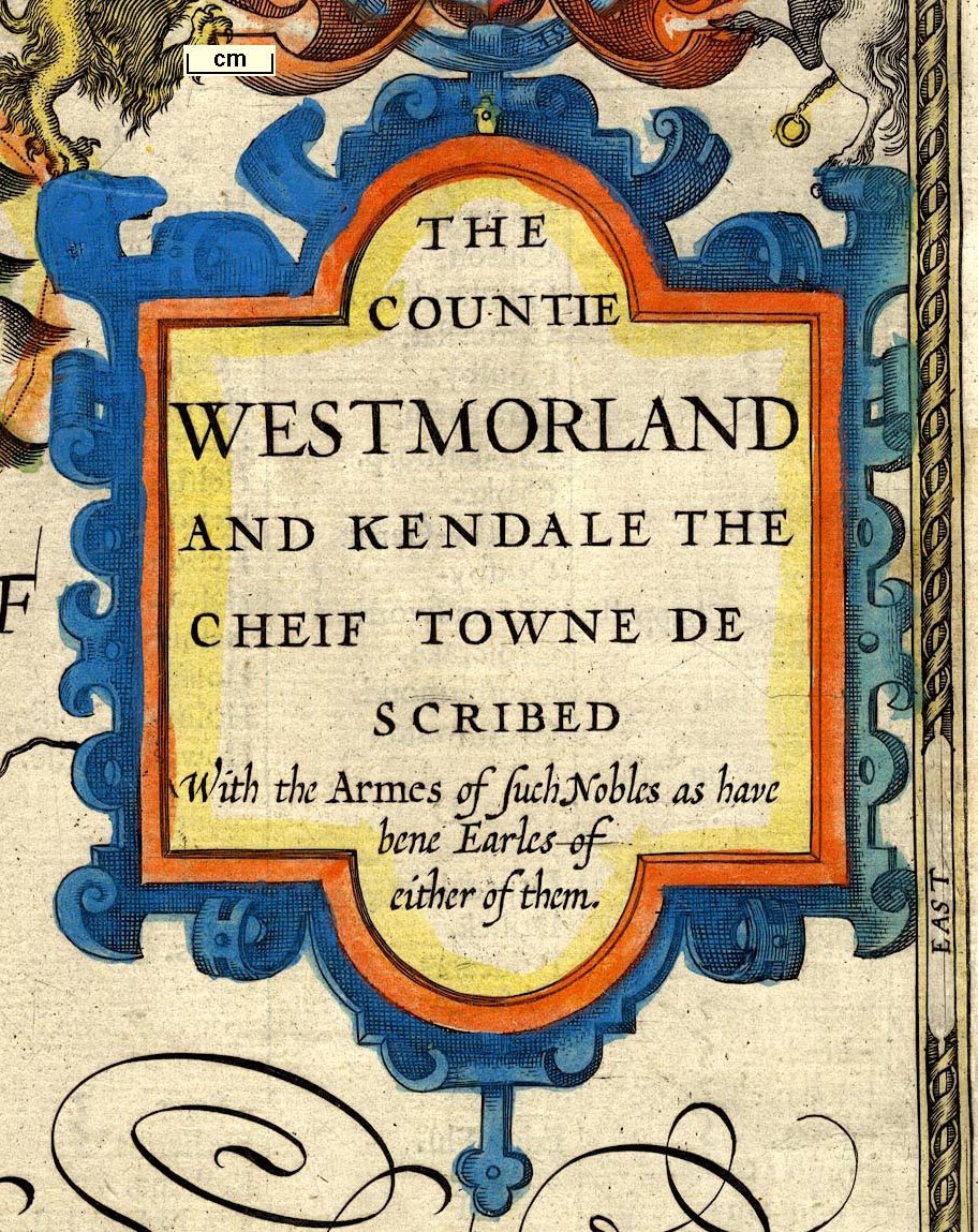
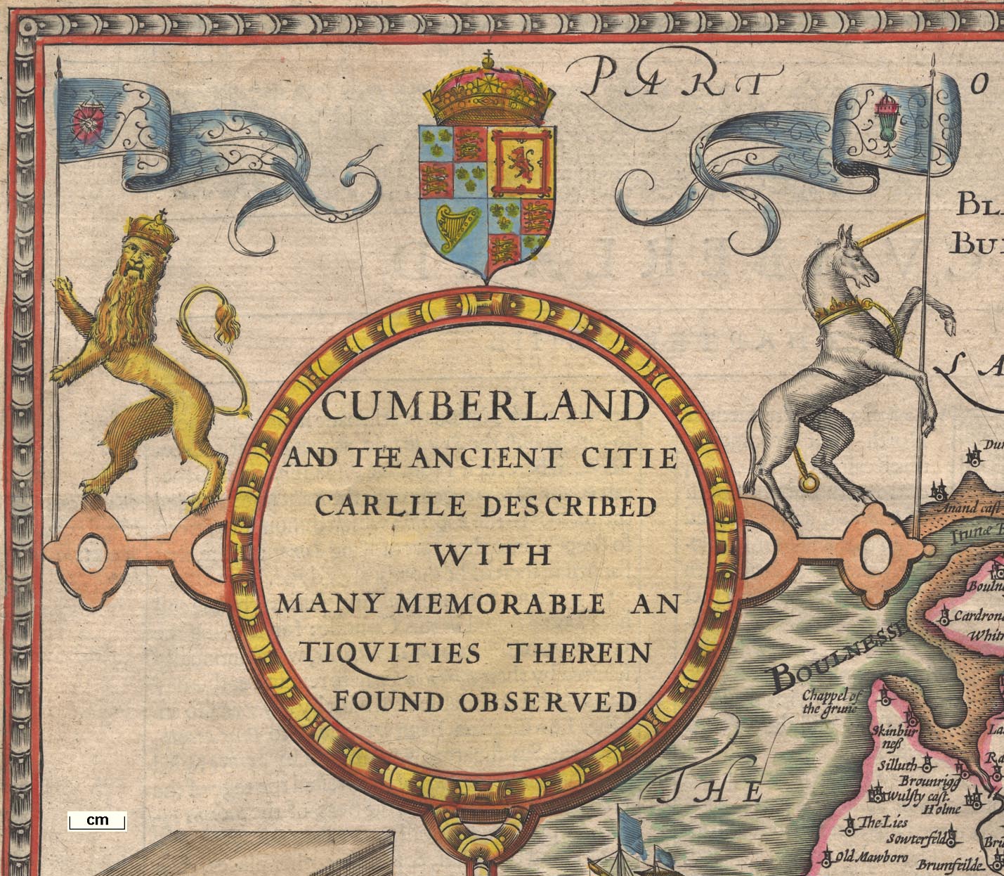
Maps, The Countie Westmorland and Kendale the Cheif
Towne, scale about 3.5 miles to 1 inch, and Cumberland and
the Ancient Citie Carlile, scale about 4 miles to 1 inch, by
John Speed, London, 1611; published 1611-1770.
Also a general map, Kingdome of Great Britaine and Ireland. Published in 'The Theatre of the Empire of Great Britaine: Presenting An Exact Geography of the Kingdomes of England, Scotland, Ireland, and the Iles adioyning: With The Shires, Hundreds, Cities and Shire-townes, within ye Kingdome of England, divided and described By John Speed. Imprinted at London. Anno, Cum Privilegio, 1611. And are to be solde by John Sudbury & Georg Humble, in Popes-head alley at ye signe of ye white Horse.' The 1611 map of Westmorland has an inset plan of Kendale, and coats of arms of Ralph Nevill, and of John Duke of Bedford, John Duke of Somerset, John de Foix, Earls of Westmorland, also the arms of Kendal and the royal arms; sold by George Humble; text on the reverse abridged from Camden's Britannia. The 1611 map of Cumberland is dated 1610, it has an inset plan of Carlile, and coats of arms of Henry Clifford, Marcatus, Ran. Mescems, Andrew Harkley, Earls of Carlisle, also the arms of Carlisle and the royal arms; sold by J Sudbury and Georg Humble; text on the reverse abridged from Camden's Britannia. The 1611 atlas has a pictorial title page, and 6 leaves of text including a dedication, contents and Speed's preface 'To the Well-affected and favourable Reader'; its size 9 1/2 x 15 ins. The maps are based on Saxton's maps of the counties, but, unlike other copyists, John Speed honestly admits 'I have put my sickle into other mens corne'. He was a dilgent researcher and added material from the libraries and collections of antiquarian friends. Note that the town plans have no scale line and so are not originally by John Speed, but are copied. This is the earliest published atlas of the British Isles, the town plans are the first comprehensive collection of such. Published in an early edition 1605-10. The early map Westmorland has the cartouche on the left is blank, and the three shields bottom left are blank, reverse blank: Cumberland has no imprint, the sea is not shaded, and the note about the Picts Wall ends at ... Battlements, blank reverse. Published in an edition of the atlas printed 1614. Published in a Latin edition 'Theatrum Imperii Magnae Britanniae: Exactam Regnorum Angliae, Scotiae, Hiberniae et Insularum adiacentium Geographia ob oculos ponens uno cum Comitatibus, Centurijs, Urbibus et primarijs Comitatum oppidis, intra Regnum Angliae, divisis et descriptis. Opus, Nuper quidem a Johanne Spedo cive Londinensi, Anglice conscriptum: Nunc vero, a Philemone Hollando, apud Coventrianos Medicinae Doctore Latinitate donatum. Imprinted at London Anno Cum Privilegio 1616 And are to be solde by John Sudbury & Georg Humble in Popes-head alley at ye signe of ye white Horse. 1616.' Latin text on the reverse of the map. Published in 'The Theatre of the Empire of Great Britaine ... by John Speed ... 1627. Are to be sold by George Humble at the Whit horse in Popes-head Alley.' The text is reset. Published in a Latin edition by Philemon Holland, 1646. Latin text is on the reverse, the initial letter having a dotted border. Published in 'Theatre of the Empire of Great Britaine ... by John Speed. Imprinted at London ... 1650. Are to be sold by Roger Rea the Elder, and younger, at the Golden Crosse agat. ye. Exchange, 1650-62.' The Cumberland map has some changes. After the Restoration, 1660, Prince Rupert was made Duke of Cumberland and his arms were added down left of the title cartouche; and the arms of James Hay, Earl of Carlisle and of Charles Howard were added on the right. The privileges and dates are erased. The text of the 1665 edition is reset in smaller type, the initial letter has a shaded leaf decoration; the map is the same except that Rea's imprint is substituted for Humble's. Published, as single maps? 'to be sold by Thomas Bassett in Fleet street and Richard Chiswell at the Rose and Crown in St. Paul's Churchyard.' from 1662 Published in 'The Theatre of the Empire of Great Britaine. ... As also A Prospect of the most famous Parts of the World. By John Speed. With many Additions never before Extant. London. Printed for Thomas Bassett and Richard Chiswell, 1676.'; and noting '... In this New Edition are added the The Principal Roads and their Branches leading to the Cities and Chief Towns in England and Wales, with their computed distances. In a new and accurate method. The Market Towns wanting in the former Impressions. A Continuation of all the Battels fought ... The Arms of all the Dukes and Earls ... to the Last Creation. ... London; Printed for Thomas Basset at the George in Fleet Street, and Richard Chiswell, at the Rose and Crown in St. Paul's Church-yard, MDCLXXVI.' 1676. The title and text pages, and the text on the reverse of the maps of the 1676 edition are much modified. The Westmorland and Cumberland maps do not have roads, which are advertised on the title page of the atlas. The Westmorland map has the coat of arms of Francis Fane upper left. Its imprint, lower right is 'Performed Iohn Speede and are to be sold by Thomas Bassett in Fleetstreet, and Ric. Chiswell in St. Paul's Churchyard.' The Cumberland map has the coat of arms of Prince Rupert upper left. The imprint is similar. In this edition the imprint on the maps is for Bassett and Chiswell; the maps are corrected as described. The maps without text were offered by Bassett and Chiswell in 1676, perhaps before their complete atlas was ready; 'Particular maps of ... any Shire and County in the Kingdom of Great Britain and Ireland, will be sold by themselves, without the Description, to such as desire them, each Map, 6d.' Speed's plates were later in possession of:- Christopher Browne, about 1690; John Overton, d1713; his son Henry Overton, d.1751; and the latter's nephew Henry; C Dicey and Co, about 1770. |
||

|
Speed 1695 | |
|
(example map Dove Cottage : 2007.38.14)
|
||
| map feature:- | picture frame border & swash lettering & title cartouche & strapwork cartouche & coat of arms & heraldic border & descriptive text & compass rose & labelled borders (English) & scale line (with dividers) & sea moire effect & coast shaded & rivers & lakes & relief & hillocks & woods & trees & parks & county & settlements | |
| inscription:- |
printed title cartouche, upper right
THE / COUNTIE / WESTMORLAND / AND KENDALE THE / CHEIF TOWNE DE- / SCRIBED / With the Armes of such Nobles as have / bene Earles of / either of them. |
|
| inscription:- |
printed below the scale line, lower right
Performed John Speede, and are to be sold by George / Humble in Popes head alley against th Exchange. |
|
| inscription:- |
water mark:
[R G ] |
|
| inscription:- |
water mark:
bunch of grapes |
|
| wxh, sheet:- | 56.5x43.5cm | |
| wxh, plate:- | 504x384mm | |
| wxh, map:- | 502x382mm | |
| inscription:- |
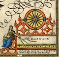
printed above the scale line
THE SCALE OF MILES |
|
| scale line:- | 9 miles = 89.4 mm | |
| scale:- | 1 to 160000 ? (1 to 162014 from scale line wrongly assuming a statute mile) | |
|
||
|
||
| references:- |
Speed, John: 1611 & 1614 & 1627=1631 & 1650=1662: Theatre of
the Empire of Great Britaine: (London) Speed, John: 1616: Theatrum Imperii Magnae Britanniae: (London) Speed, John: 1627: Theatre of the Empire of Great Britain, The: Humble, George (London) Speed, John: 1646: Theatre of the Empire of Great Britain, The: Humble, William (London) Speed, John: 1665: Theatre of the Empire of Great Britain, The: Rea, Roger (London) Speed, John: 1676: Theatre of the Empire of Great Britain, The: Bassett, Thomas & Chiswell, Richard (London) Hodges, C W: 1949: John Speed's Theatre, Some Reflections on the Style of the Elizabethan Playhouse: Theatre Notebook: 3: pp.28-31 Skelton, R A: 1952: Tudor Town Plans in John Speed's Theatre: Archaeological J: 108: pp.109-20 Arlott, J (ed): 1953: John Speed's England (facsimile): (London) |
|
| sources:- |
Chubb 1927 (XXII) Curwen 1918 Armitt Library Wordsworth Trust Collection private collection Kendal Library Maps Carlisle Library Maps |
|
| items seen (illustrated items in bold, * have map squares etc):- | ||
|
|
Armitt Library : 1959.187 -- map -- Cumberland -- Carlile | |
|
|
Armitt Library : A6632 -- atlas -- Theatre of the Empire of Great Britain | |
|
|
Armitt Library : A6632.1 -- map -- Kingdome of Great Britain and Ireland | |
|
|
Armitt Library : A6632.2 -- map -- Britain as it was Devided in the tyme of the Englishe Saxons especially during their Heptarchy | |
|
|
Armitt Library : A6632.3 -- map -- Kingdome of England | |
|
|
Armitt Library : A6632.4 -- map -- Kent | |
|
|
Armitt Library : A6632.5 -- map -- Sussex | |
|
|
Armitt Library : A6632.6 -- map -- Surrey | |
|
|
Armitt Library : A6632.7 -- map -- Hantshire | |
|
|
Armitt Library : A6632.8 -- map -- Wight Island | |
|
|
Armitt Library : A6632.9 -- map -- Dorsetshyre | |
|
|
Armitt Library : A6632.10 -- map -- Devonshire | |
|
|
Armitt Library : A6632.11 -- map -- Cornwall | |
|
|
Armitt Library : A6632.12 -- map -- Somersetshire | |
|
|
Armitt Library : A6632.13 -- map -- Wilshire | |
|
|
Armitt Library : A6632.14 -- map -- Barkshire | |
|
|
Armitt Library : A6632.15 -- map -- Middlesex | |
|
|
Armitt Library : A6632.16 -- map -- Essex | |
|
|
Armitt Library : A6632.17 -- map -- Suffolk | |
|
|
Armitt Library : A6632.18 -- map -- Cambridgshire | |
|
|
Armitt Library : A6632.19 -- map -- Hartford Shire | |
|
|
Armitt Library : A6632.20 -- map -- Bedford Shire | |
|
|
Armitt Library : A6632.21 -- map -- Buckingham Shyre | |
|
|
Armitt Library : A6632.22 -- map -- Oxfordshire | |
|
|
Armitt Library : A6632.23 -- map -- Glocestershire | |
|
|
Armitt Library : A6632.24 -- map -- Herefordshire | |
|
|
Armitt Library : A6632.25 -- map -- Worcester Shire | |
|
|
Armitt Library : A6632.26 -- map -- Counti of Warwick, The | |
|
|
Armitt Library : A6632.27 -- map -- Northamton Shire | |
|
|
Armitt Library : A6632.28 -- map -- Huntington Shire | |
|
|
Armitt Library : A6632.29 -- map -- Rutlandshire | |
|
|
Armitt Library : A6632.30 -- map -- Leicester County | |
|
|
Armitt Library : A6632.31 -- map -- County of Lyncolne, The | |
|
|
Armitt Library : A6632.32 -- map -- Countie of Nottingham | |
|
|
Armitt Library : A6632.33 -- map -- Darbieshire | |
|
|
Armitt Library : A6632.34 -- map -- Stafford Countie | |
|
|
Armitt Library : A6632.35 -- map -- Shropshyre | |
|
|
Armitt Library : A6632.36 -- map -- Countye Palatine of Chester | |
|
|
Armitt Library : A6632.37 -- map -- Countie Palatine of Lancaster | |
|
|
Armitt Library : A6632.38 -- map -- York Shire | |
|
|
Armitt Library : A6632.39 -- map -- West Ridinge of Yorkshyre | |
|
|
Armitt Library : A6632.40 -- map -- North and East Ridins of Yorkshire | |
|
|
Armitt Library : A6632.41 -- map -- Bishoprick of Durham | |
|
|
Armitt Library : A6632.42 -- map -- | |
|
|
Armitt Library : A6632.43 -- map -- Cumberland | |
|
|
Armitt Library : A6632.44 -- map -- Northumberland | |
|
|
Armitt Library : A6632.45 -- map -- Isle of Man, The | |
|
|
Armitt Library : A6632.46 -- map -- Holy Island -- Garnsey -- Jarsey -- Farne | |
|
|
Armitt Library : A6632.47 -- map -- Wales | |
|
|
Armitt Library : A6632.48 -- map -- Penbrokshyre | |
|
|
Armitt Library : A6632.49 -- map -- Caermarden Shyre | |
|
|
Armitt Library : A6632.50 -- map -- Glamorgan Shyre | |
|
|
Armitt Library : A6632.51 -- map -- Monmouthshire | |
|
|
Armitt Library : A6632.52 -- map -- Breknoke Shyre | |
|
|
Armitt Library : A6632.53 -- map -- Countie of Radnor | |
|
|
Armitt Library : A6632.54 -- map -- Cardigan Shyre | |
|
|
Armitt Library : A6632.55 -- map -- Montgomery Shire | |
|
|
Armitt Library : A6632.56 -- map -- Merionethshire | |
|
|
Armitt Library : A6632.57 -- map -- Denbighshire | |
|
|
Armitt Library : A6632.58 -- map -- Flintshire | |
|
|
Armitt Library : A6632.59 -- map -- Caernarvon Shyre | |
|
|
Armitt Library : A6632.60 -- map -- Anglesey | |
|
|
Armitt Library : A6632.61 -- map -- Invasions of England and Ireland | |
|
|
Armitt Library : A6632.62 -- road diagram -- West Road from London to Bristol | |
|
|
Armitt Library : A6632.63 -- road diagram -- Western Road London to the Lands End in Cornwall | |
|
|
Armitt Library : A6632.64 -- road diagram -- North Road from London to Barwick | |
|
|
Armitt Library : A6632.65 -- road diagram -- South East, South and South West Roads from London | |
|
|
Armitt Library : A6632.66 -- road diagram -- North West Road from London to Hollyhead and its branches | |
|
|
Armitt Library : A6632.67 -- map -- Kingdome of Scotland | |
|
|
Armitt Library : A6632.68 -- map -- Kingdome of Ireland | |
|
|
Armitt Library : A6632.69 -- map -- Province of Mounster | |
|
|
Armitt Library : A6632.70 -- map -- Countie of Leinster | |
|
|
Armitt Library : A6632.71 -- map -- Province of Connaugh | |
|
|
Armitt Library : A6632.72 -- map -- Province Ulster, The | |
|
|
Armitt Library : A6632.73 -- map -- New and Accurat Map of the World | |
|
|
Armitt Library : A6632.74 -- map -- Asia | |
|
|
Armitt Library : A6632.75 -- map -- Africae | |
|
|
Armitt Library : A6632.76 -- map -- Europ | |
|
|
Armitt Library : A6632.77 -- map -- America | |
|
|
Armitt Library : A6632.78 -- map -- Greece -- Ellas | |
|
|
Armitt Library : A6632.79 -- map -- New Mappe of the Romane Empire | |
|
|
Armitt Library : A6632.80 -- map -- Newe Mape of Germany | |
|
|
Armitt Library : A6632.81 -- map -- Bohemia | |
|
|
Armitt Library : A6632.82 -- map -- France | |
|
|
Armitt Library : A6632.83 -- map -- New Mape of the 17 Provinces of Low Germany -- Belgia | |
|
|
Armitt Library : A6632.84 -- map -- Spaine | |
|
|
Armitt Library : A6632.85 -- map -- Italia | |
|
|
Armitt Library : A6632.86 -- map -- Mape of Hungari | |
|
|
Armitt Library : A6632.87 -- map -- Kingdome of Denmarke | |
|
|
Armitt Library : A6632.88 -- map -- Newe Mape of Poland | |
|
|
Armitt Library : A6632.89 -- map -- Kingdome of Persia | |
|
|
Armitt Library : A6632.90 -- map -- Turkish Empire, The | |
|
|
Armitt Library : A6632.91 -- map -- Kingdome of China, The | |
|
|
Armitt Library : A6632.92 -- map -- Newe Mape of Tartary | |
|
|
Armitt Library : A6632.93 -- map -- Mapp of the Sommer Ilands -- Bermuda | |
|
|
Armitt Library : A6632.94 -- map -- Map of Virginia and Maryland | |
|
|
Armitt Library : A6632.95 -- map -- Map of New England and New York | |
|
|
Armitt Library : A6632.96 -- map -- Map of Jamaica -- Barbados | |
|
|
Armitt Library : A6632.97 -- map -- New Description of Carolina | |
|
|
Armitt Library : A6632.98 -- map -- New Map of East India | |
|
|
Armitt Library : A6632.99 -- map -- Map of Russia | |
|
|
Armitt Library : A6632.100 -- map -- Canan -- Palestine | |
|
|
Armitt Library : ALMC2008.14.5 -- map -- Countie Westmorland and Kendale the Cheif Towne -- Kendale * | |
|
|
Armitt Library : ALMC2008.14.8 -- map -- Countie Westmorland and Kendale the Cheif Towne -- Kendale | |
|
|
Carlisle Library : Map 1 -- map -- Cumberland and the Ancient Citie Carlile Described | |
|
|
Carlisle Library : Map 21 -- map -- Cumberland and the Ancient Citie Carlile Described | |
|
|
Carlisle Library : Map 66 -- map -- Countie Westmorland and Kendale the Cheif Towne -- Kendale | |
|
|
Carlisle Library : Map 235 -- street map -- View of Antient Carlisle | |
|
|
Carlisle Library : Map 306 -- map -- Cumberland and the Ancient Citie Carlile Described | |
|
|
Carlisle Library : Map 315 -- map -- Cumberland and the Ancient Citie Carlile Described | |
|
|
Carlisle Library : Map 348 -- map -- Countie Westmorland and Kendale the Cheif Towne -- Kendale | |
|
|
Dove Cottage : 2007.38.14 -- map -- Countie Westmorland and Kendale the Cheif Towne -- Kendale | |
|
|
Kendal Library : Map 1 -- map -- Countie Westmorland and Kendale the Cheif Towne -- Kendale | |
|
|
Kendal Library : Map 99 -- map -- Countie Westmorland and Kendale the Cheif Towne -- Kendale | |
|
|
Kendal Library : Map 100 -- map -- Countie Westmorland and Kendale the Cheif Towne -- Kendale | |
|
|
Kendal Library : Map 101 -- map -- Countie Westmorland and Kendale the Cheif Towne -- Kendale | |
|
|
Kendal Library : Map 113 -- map -- Kendale | |
|
|
Kendal Library : Map 114 -- map -- Kingdome of England | |
|
|
private collection (16) -- map -- Cumberland and the Ancient Citie Carlile Described -- Carlile * | |
|
|
private collection (85) -- map -- Kingdome of Great Britaine and Ireland | |