 Speed 1611

|

|
|
|
item:- Armitt Library : A6632.39 image:- © see bottom of page |
click to enlarge |
|
|
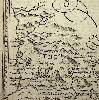
Map, uncoloured engraving, The West Ridinge of Yorkshyre,
scale about 4 miles to 1 inch, by John Speed 1610, published
by Thomas Bassett, The George, Fleet Street, and Richard
Chiswell, The Rose and Crown, St Paul's Churchyard, London,
1676.
The reverse of the map is pp.79 and 80; text in English. Included in The Theatre of the Empire of Great Britain by John Speed. |
||

|
Speed 1611 | |
| map feature:- | scroll cartouche & swash lettering & heraldic border & coat of arms, royal & coat of arms (earls and dukes) & inset map (YORKE with A Scale of Pases) & swash lettering & up is N & labelled borders & scale line & dividers & rivers & relief & hillocks & woods & forests & parks & county & settlements | |
| inscription:- |
printed scroll cartouche, upper middle
THE WEST RIDINGE / OF YORKSHYRE / with the most famous and fayre / Citie of YORKE described / 1610 |
|
| inscription:- |
printed lower left
Performed by Iohan Speede / And are to be sold by Thomas Bassett in Fleetstreet, and by / Richard Chiswel in St. Pauls Church yard. |
|
| inscription:- |
printed reverse, p.79
THE West Riding of Yorkshire. / CHAPTER XL. / THE other division, which is called the West-Riding of York shire, lying towards the North-West, carrieth a great compass : On the North side it borders upon part of the North-Riding; on the East upon part of the East Riding, and a part of Lincolnshire, The West side is neighboured with part of Lancashire : The South confined with Nottingham and part of Darby-shires. ... |
|
| inscription:- |
printed with scale line
The Scale of Miles |
|
| scale line:- | 14 miles = 86.1 mm | |
| wxh, map:- | 511x382mm (about) | |
| scale:- | 1 to 260000 ? (1 to 261682 from scale line, wrongly assuming a statute mile) | |