 Speed 1611

|

|
|
|
item:- Armitt Library : A6632.45 image:- © see bottom of page |
click to enlarge |
|
|
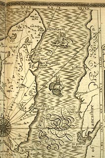
Map, uncoloured engraving, The Isle of Man, scale about 2
miles to 1 inch, by Thomas Durham, 1595, edited by John
Speed 1610, published by Thomas Bassett, The George, Fleet
Street, and Richard Chiswell, The Rose and Crown, St Paul's
Churchyard, London, 1676.
The map uses two scales - the islands has its own scale line, but the coasts of England and Scotland are plotted using an alternative scale, about 8.5 miles to 1 inch, places being marked at the respective distance along a rhumb line from the compass rose. The reverse of the map is pp. 91 and 92; text in English. Included in The Theatre of the Empire of Great Britain by John Speed. |
||

|
Speed 1611 | |
| map feature:- | picture frame border & strapwork cartouche & swash lettering & coat of arms, royal & coat of arms & beasts (carrying the flags of England, Scotland, Ireland, Wales) & compass rose & rhumb lines & labelled borders (English; labelled at the end of each rhumb line as - NORTH, N.B.E., N.N.E., N.B.E.N., N.E., N.B.EE., E.N.E., E.B.N., EAST, and so on) & up is N & scale line & dividers & sea moire effect & galleons & sea monsters & coast shaded & rivers & relief & hillocks & woods & settlements | |
| inscription:- |
printed title cartouche
THE ISLE OF MAN / Exactky described, and into several Parish : / shes divided, with every Towne, Village, / Baye, Creke, and River therein contey : / ned. The bordringe Coasts wherewith / it is circulated in their Situation sett, and / by the Copmase accordi~gly shewed, With / their true distance from every place / Unto this Island by a severall / scale observed |
|
| inscription:- |
printed lower middle
Performed by John Speede. / And are to be sold by Tho : Bassett in Fleetstreet, / and Richard Chiswell in St. Pauls Church : yard. |
|
| inscription:- |
printed p.91
Book 1. Chap. 45. 91 / MAN ISLAND / THE isle of Man is termed by Ptolemy, Moneda; by Pliny, Monabia; by Orosius, Menavia; by Beda, Menavia secunda; and by Gyldas, Eubonia, and Manaw. The Britains name it Menow; the Inhabitants, Maninge; and we Englishmen, The Isle of Man. It boundeth North-ward upon Scotland, Southward upon the Isle of Anglesey, East-ward upon part of Lancashire, and Westward upon the Coast of Ireland. ... |
|
| inscription:- |
printed cartouche on left
DESCRIBED / BY / THO DURHAM / Ano. 1595 |
|
| inscription:- |
printed cartouche on the right
PERFORMED / BY. / JOHN SPEED / Anno 1610 |
|
| inscription:- |
printed with the island scale line
THIS SCALE SCALE Conteyneth the Miles / of the Island it selfe, and is to be mea : / sured according to the usuall manner |
|
| scale line, island:- | 5 miles = 57.2 mm | |
| inscription:- |
printed with the coasts scale line
THIS SCALE is to be measured from the / Compass in the midst of the Island unto / the brodring Coasts of England, Scot : / land, Ireland, and Wales. |
|
| scale line, coasts:- | 20 miles = 60.1 mm | |
| wxh, map:- | 509x383mm (about) | |
| scale, island:- | 1 to 140000 ? (1 to 140677 from scale line, wrongly assuming a statute mile) | |
| scale, coasts:- | 1 to 540000 ? (1 to 535555 from scale line, wrongly assuming a statute mile) | |