 Speed 1611

|

|
|
|
item:- Armitt Library : A6632.44 image:- © see bottom of page |
click to enlarge |
|
|
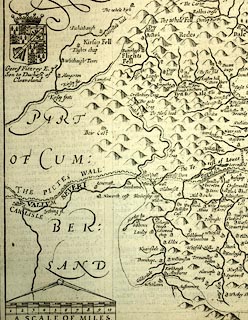
Map, uncoloured engraving, Northumberland, scale about 4
miles to 1 inch, by John Speed 1610, published by Thomas
Bassett, The George, Fleet Street, and Richard Chiswell, The
Rose and Crown, St Paul's Churchyard, London, 1676.
Inset maps of Barwick, and Newe Castle which is described by William Mathew. The reverse of the map is pp. 89 and 90; text in English. Included in The Theatre of the Empire of Great Britain by John Speed. |
||

|
Speed 1611 | |
| map feature:- | picture frame border & scroll cartouche & swash lettering & coat of arms, royal & coat of arms & heraldic border & inset map (BARWICK) & inset map (NEWE CASTLE) & labelled borders (English) & up is N & scale line & dividers & sea moire effect & coast shaded & rivers & relief & hillocks & woods & parks & county & settlements | |
| inscription:- |
printed title cartouche
NORTHUM : / BERLAND |
|
| inscription:- |
printed lower middle
Performed by John Speede and are to be sould by Thomas / Bassett in Fleetstreet, and Richard Chiswell in / St. Pauls Church : yard. |
|
| inscription:- |
printed with scale line
A SCALE OF MILES |
|
| scale line:- | 10 miles = 67.8 mm | |
| wxh, map:- | 511x384mm (about) | |
| scale:- | 1 to 240000 ? (1 to 237366 from scale line, wrongly assuming a statute mile) | |