 Speed 1611

|

|
|
|
item:- Dove Cottage : 2007.38.14 image:- © see bottom of page |
click to enlarge |
|
|
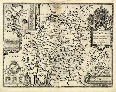
Map, uncoloured engraving, The Countie Westmorland and
Kendale the Cheif Towne, scale about 2.5 miles to 1 inch, by
John Speed, 1610, published by George Humble, Popes Head
Alley, London, 1611-12.
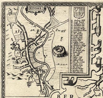
One of the county maps in the Theatre of the Empire of Great Britain, by John Speed. The map of Kendal is an inset map, a bird's eye view, at a larger scale, with a gazetteer of places. The reverse of the map is blank. This is perhaps a later edition, about 1627? |
||

|
Speed 1611 | |
| map feature:- | picture frame border & swash lettering & strapwork cartouche & coat of arms & heraldic border & descriptive text & compass rose & labelled borders (English) & scale line (with dividers) & sea moire effect & coast shaded & rivers & lakes & relief & hillocks & woods & parks & county & settlements & inset map | |
| inscription:- |
printed title cartouche, upper right
THE / COUNTIE / WESTMORLAND / AND KENDALE THE / CHEIF TOWNE DE- / SCRIBED / With the Armes of such Nobles as have / bene Earles of / either of them. |
|
| inscription:- |
printed below the scale line, lower right
Performed John Speede, and are to be sold by George / Humble in Popes head alley against th Exchange. |
|
| inscription:- |
printed above the scale line
THE SCALE OF MILES |
|
| inscription:- |
water mark:
[R G ] |
|
| inscription:- |
water mark:
bunch of grapes |
|
| scale line:- | 9 miles = 89.4 mm | |
| wxh, sheet:- | 56.5x43.5cm | |
| wxh, plate:- | 504x384mm | |
| wxh, map:- | 502x382mm | |
| scale:- | 1 to 160000 ? (1 to 162014 from scale line wrongly assuming a statute mile) | |
|
||
|
||
|
||