 Speed 1611

|

|
|
|
item:- Armitt Library : A6632.43 image:- © see bottom of page |
click to enlarge |
|
|
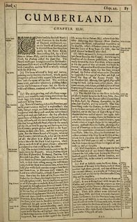
Map, uncoloured engraving, Cumberland, scale about 4
miles to 1 inch, by John Speed 1611, published by Thomas
Bassett, The George, Fleet Street, and Richard Chiswell, The
Rose and Crown, St Paul's Churchyard, London, 1676.
There is an inset map of Carlile. The reverse of the map is pp.87 and 88; text in English. The map has added coats of arms since the first edition - Prince Rupert, Duke of Cumberland; James Hay, Earl of Carlisle; and Charles Howard, Earl of Carlisle. Included in The Theatre of the Empire of Great Britain by John Speed. |
||

|
Speed 1611 | |
| map feature:- | picture frame border & picture frame cartouche & coat of arms & heraldic border & descriptive text & vignettes & labelled borders & scale line & sea moire effect & coast shaded & rivers & bridges & lakes & relief & hillocks & woods & forests & parks & county & settlements & inset map | |
| inscription:- |
printed title cartouche, upper left
CUMBERLAND / AND THE ANCIENT CITIE / CARLILE DESCRIBED / WITH / MANY MEMORABLE AN / TIQUITIES THEREIN / FOUND OBSERVED |
|
| inscription:- |
printed reverse, p.87
CUMBERLAND. / CHAPTER XLIV. / CUmberland, the furthest North-west Province in this Realm of England, confronteth upon the South of Scotland, and is divided from that Kingdom partly by the River Kirsop, then crossing Esk, by a Tract thorow Solome-Moss, until it come to the Solway Frith, by Ptolemy called Itune-Bay. The North-west part is neighboured by Northumberland, more East-ward with Westmorland, the South with Lancashire, and the West is wholly washed with the Irish Sea. ... |
|
| inscription:- |
printed lower right of centre
Performed by John Speed, and are to be / sould in Popes. head Alley, by the exchan : / ge by J. Sudbury and Georg. Humble. / Cum Privilegio Anno Domini 1610. |
|
| inscription:- |
printed with scale line
THE SCALE OF MILES |
|
| scale line:- | 10 miles = 65.0 mm | |
| wxh, map:- | 511x384mm (about) | |
| scale:- | 1 to 250000 ? (1 to 247591 from scale line, wrongly assuming a statute mile) | |
|
||