 Bowen 1720

|

|
|
|
map type:- Bowen 1720 |
|
|
|
Road book, Britannia Depicta Or Ogilby Improv'd,
including road strip maps with sections in Westmorland and
Cumberland, scale about 2 miles to 1 inch, derived from maps
by Ogilby, 1675, also a county map of Westmorland, scale
about 8 miles to 1 inch, and of Cumberland, scale about 16.5
miles to 1 inch, each with text, by John Owen, published by
Emanuel Bowen, London, 1720; published 1720-64.
Published in 'Britannia Depicta Or Ogilby Improv'd; Being a Correct Coppy of Mr. Ogilby's Actual Survey of all ye Direct & Principal Cross Roads in England and Wales: Wherein are exactly Delineated & Engraven, All ye Cities, Towns, Villages, Churches, Seats &c. scituate on or near the Roads, with their respective Distances in Measured and Computed Miles. And to render this Work universally Usefull & agreeable, [beyond any of it's kind] are added in a clear & most Compendious Method.' '1, A full & particular Description & Account of all the Cities, Borough-Towns, Towns-Corporate &c. their Arms, Antiquity, Charters, Privileges, Trade, Rarities, &c. with suitable Remarks on all places of Note drawn from the best Historians and Antiquaries. By Jno. Owen of the Midd: Temple Gent.' '2, The Arms of the Peers of this Realm who derive their Titles from Places lying on, or near the Roads.' '3, The Arms of all ye Bishopricks & Deaneries, their foundation, Extent, Yearly-Value, Number of Parishes &c.' '4, The Arms, & a succint Account of both Universities & their respective Colleges, their foundations Fellowships &c.' 'Lastly Particular & Correct Maps of all ye Counties of South Britain; with a Summary description of each County, it's Circumference, Number of Acres, Boro' & Market Towns & Parishes, Air, Soil, Com~odities, Manufactures & what each Pays in ye 2sh. Aid &c. The Whole for its Compendious Variety & Exactness, preferable to all other Books of Roads hitherto Published or Proposed; and calculated not only for the direction of the Traveller [as they are] but the general use of the Gentleman and Tradesman. By Eman: Bowen Engraver London Printed for, & Sold by Tho: Bowles Print & Map Seller next ye Chapter House in St. Pauls Church-Yard & Em. Bowen next ye King of Spain in S: Katherines. 1720.' The road book has a title page and two prefatory pages of text; its size is 4 5/8 x 7 1/8 ins; the maps are two sided; as well as strip maps there are maps of each county. The pages which concern Westmorland and Cumberland, now Cumbria, are 90, 93, 94, 160, 161, 230, 231, 232, 259, 260, 261, 271. p.90 title cartouche for 'THE ROAD FROM LONDON TO CARLISLE IN CUMBERLAND ...' including a table of distances from London for the road from Lancaster, Lancashire; through Burton, Kendal, Thrumby, Penrith, Westmorland; to Carlisle, Cumberland; and the county map of Staffordshire. p.93 Road from London to Carlisle - from Garstang, through Lancaster, Lancashire; then Burton, to beyond Kendal, Westmorland; and the descriptive text for Kendal etc. p.94 Road from London to Carlisle - from just north of Kendal, through Shap and Thrumby, Westmorland; then Penrith to Carlisle, Cumberland; and the desciptive text for Penrith etc. p.160 title cartouche for 'The Road from CARLISLE to RARWICK ...' including a table of distances from Carlisle from Carlisle through Brakenhill, Cumberland; and in and out of Scotland and England; and the county map of the North and East Riding of Yorkshire. p.161 Road from Carlisle to Berwick - from Carlisle; into Scotland at the Kisksop river; and the coat of arms and descriptive text for Carlisle. p.230 title cartouche for 'THE ROAD FROM TINMOUTH ... to CARLISLE ...'; and the county map of Northumberland. p.231 coat of arms and descriptive text for the Bishopric of Carlisle; and the road from Tinmouth through Newcastle to Hexham, Northumberland. p.232 Road from Tynemouth to Carlisle - from west of Hexham through Haltwesel, Northumberland; across the Poltrose Burn and to Carlisle, Cumberland; coat of arms and descriptive text for the Deanery of Carlisle; descriptive text of Warwick Stone Bridge, etc. p.259 title cartouche for 'The Roads from KENDAL to COCKERMOUTH, &c.' including a table of distances from Kendal through Stanley and Ambleside, Westmorland; on to Keswick and Cockermouth, Cumberland; and the county map and descriptive text of Cumberland. p.260 Road from Kendal to Cockermouth - from Kendal, through Stanley ie Staveley, past Winander Meer, then Ambleside, Westmorland; on past Keswick, Cumberland; and the descriptive text for Winander Meer, Dunmail Raise Stones, Kendal, and Ambleside. p.261 Road from Kendal to Cockermouth - to Cockermouth; and the road from Egremont to Carlisle, Cumberland; and descriptive text for Cockermouth, and Egremont. p.271 county map and descriptive text of Westmorland; and title cartouche for the road from Whitby to Scarborough. Published in editions 1720, about 1722, 1723, 1724, 1730, 1731, 1734, 1736, 1749, 1751, 1753, 1759, 1764, after 1764. By 1759 nearly every plate has some sort of correction, but in the main the plates are the same for all editions. The county map has a scale line, aligned vertically; the road strip maps have only the mile marks on the roads. |
||
|
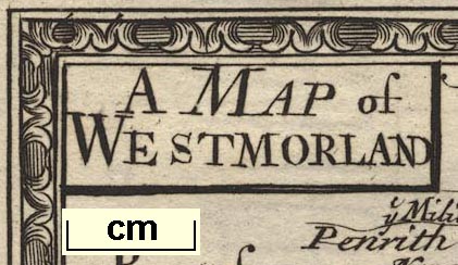
Example County Map (private collection)
|
||
| map feature:- | picture frame border & plain cartouche & scale line & up is N & sea plain & coast shaded & rivers & relief & hillocks & county & settlements & roads & descriptive text | |
| wxh, sheet:- | 14x19.5cm | |
| wxh, map:- | 115x112mm | |
| inscription:- |
printed upper left in a plain cartouche
A MAP of / WESTMORLAND |
|
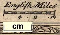
| scale line:- | 10 miles = 31.8 mm | |
| scale:- | 1 to 500000 ? (1 to 506083 from scale line, wrongly assuming a statute mile) | |
|
||
|
||
| references:- |
Bowen, Emanuel & Owen, John: 1720 & 1721 & 1723: Britannia
Depicta & Ogilby Improved: Bowen, Emanuel & Bowles, Thomas
(London) Bowen, Emanuel & Owen, John: 1724 & 1731: Britannia Depicta & Ogilby Improved: Bowles, Thomas & Bowles, J (London) Bowen, Emanuel & Owen, John: 1736 & 1751 & 1753 & 1759: Britannia Depicta & Ogilby Improved: Bowles, Thomas (London) Bowen, Emanuel & Owen, John: 1764: Britannia Depicta & Ogilby Improved: Bowles, Carington (London) Bowen, Emanuel: 1970 (facsimile) & 1720 (source): Britannia Depicta & Ogilby Improved: Graham, Frank (6 Queens Terrace, Newcastle upon Tyne):: good introductory essay by J B Harley |
|
| sources:- |
Chubb 1927 (CXLVII) JandMN Collection David Webb Collection HMCMS Map Collection Wordsworth Trust Collection Kendal Library Maps |
|
| items seen (illustrated items in bold):- | ||

|
Armitt Library : ALMC2008.14.117 -- map -- Westmorland | |
|
|
Armitt Library : ALMC2008.14.118 -- strip map (pl.93/94) -- Road from London to Carlisle | |
|
|
Dove Cottage : 2007.38.82 -- map -- Westmorland | |
|
|
Dove Cottage : 2007.38.99 -- strip map (pl.93/94) -- Road from London to Carlisle | |
|
|
Dove Cottage : 2007.38.100 -- strip map (pl.93/94) -- Road from London to Carlisle | |
|
|
Dove Cottage : Lowther.2 -- map -- Westmorland | |
|
|
Dove Cottage : Lowther.35 -- map -- Cumberland | |
|
|
Dove Cottage : Lowther.36 -- strip map (plate 261) | |
|
|
Dove Cottage : Lowther.103 -- print | |
|
|
Dove Cottage : Lowther.110 -- print | |
|
|
JandMN (10) -- map -- Westmorland | |
|
|
JandMN (19) -- map -- Westmorland | |
|
|
JandMN (65_161) -- strip map (pl.161) -- Road from Carlisle to Barwick | |
|
|
JandMN (65_162) -- strip map (pl.162) -- Road from Carlisle to Barwick | |
|
|
JandMN (65_231) -- strip map (pl.231) -- Road from Tinmouth to Carlisle | |
|
|
JandMN (65_232) -- strip map (pl.232) -- Road from Tinmouth to Carlisle | |
|
|
JandMN (445) -- map -- Westmorland | |
|
|
Kendal Library : Map 17 -- map -- Westmorland | |
|
|
Kendal Library : Map 47 -- map -- Westmorland | |
|
|
private collection (1_93) -- strip map (pl.93) -- Road from London to Carlisle | |
|
|
private collection (1_94) -- strip map (pl.94) -- Road from London to Carlisle | |
|
|
private collection (1_260) -- strip map (pl.260) -- Road from Kendal to Cockermouth | |
|
|
private collection (1_271) -- map -- Westmorland | |