 Bowen 1720

|

|
|
|
item:- private collection (1_260) image:- © see bottom of page |
click to enlarge |
|
|
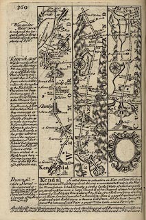
Road strip map, uncoloured engraving, pl.260, The Road
from Kendal to Cockermouth, scale about 2 miles to 1 inch,
with sections in Westmorland and Cumberland, published by
Emanuel Bowen, St Katherines, London, 1720.
From Kendal, through Stanley ie Staveley, past Winander Meer ie Windermere, then Ambleside, Westmorland; on past Keswick, Cumberland; the map also has the descriptive text for Winander Meer, Dunmail Raise Stones, Kendal, and Ambleside, and empty cartouche for a coat of arms. Published in Britannia Depicta Or Ogilby Improv'd, with text by John Owen, by Emanuel Bowen from 1720 to after 1764. |
||

|
Bowen 1720 | |
| map feature:- | compass rose & up is destination & rivers & relief & hillocks & county & settlements & roads & descriptive text & coat of arms | |
|
|
notes | |