 Bowen 1720

|

|
|
|
item:- Armitt Library : ALMC2008.14.118 image:- © see bottom of page |
click to enlarge |
|
|
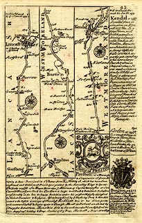
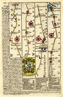
Road strip map, part of The Road from London to Carlisle,
through Lancashire, Westmorland and Cumberland, scale about
2 miles to 1 inch, published by Emanuel Bowen, St
Katherines, London, after 1720.
Published in Britannia Depicta Or Ogilby Improv'd, with text by John Owen. Plate 93 - from Garstang and Lancaster, Lancashire; through Burton, to past Kendal, Westmorland; The map also has the coat of arms and descriptive text for Preston and Bolton, and descriptive text for Carlton and Kendal. Plate 94 - from just north of Kendal, through Shap and Thrumby, Westmorland; then Penrith to Carlisle, Cumberland; The map also has the descriptive text for Penrith, and coat of arms and descriptive text for Newton. |
||

|
Bowen 1720 | |
| map feature:- | compass rose & up is destination & rivers & relief & hillocks & county & settlements & roads & road distances & distances from London & descriptive text & coat of arms | |
|
||