 Bowen 1720

|

|
|
|
item:- JandMN (10) image:- © see bottom of page |
click to enlarge |
|
|
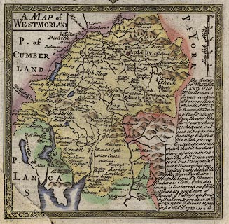
Map, hand coloured engaving, pl.271, A Map of
Westmorland, scale about 8 miles to 1 inch, published by
Emanuel Bowen, St Katherines, London, 1720.
The map has a descriptive text for Westmorland, and the title cartouche for The Roads from York to Whitby and Scarboro'. The reverse is page 272, part of the road north from York through New Malton and Pickering. Published in Britannia Depicta Or Ogilby Improv'd, with text by John Owen, by Emanuel Bowen from 1720 to after 1764. |
||

|
Bowen 1720 | |
| map feature:- | picture frame border & plain cartouche & up is N & scale line & rivers & bridges & relief & hillocks & county & settlements & roads & descriptive text | |
| inscription:- |
printed title cartouche, upper left
A MAP of / WESTMORLAND |
|
| inscription:- |
printed with scale line
English Miles |
|
| scale line:- | 10 miles = 31.9 mm | |
| wxh, map:- | 116x114mm | |
| scale:- | 1 to 500000 ? (1 to 504497 from scale line) | |
|
|
notes | |