 Bowen 1720

|

|
|
|
item:- Armitt Library : ALMC2008.14.117 image:- © see bottom of page |
click to enlarge |
|
|
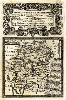
Map, uncoloured engraving, A Map of Westmorland, scale
about 8 miles to 1 inch, published by Emanuel Bowen, St
Katherines, London, 1720, perhaps an edn 1731?
Plate 271 in Britannia Depicta Or Ogilby Improv'd, with text by John Owen, published by Emanuel Bowen from 1720 to after 1764. The map has a descriptive text for Westmorland, and the title cartouche for The Roads from York to Whitby and Scarboro'. The reverse of the plate has the beginning of a road from York, through Whitwell, New Malton, Pickering, Yorkshire, ... and descriptive text for New Malton and for Whitby. |
||

|
Bowen 1720 | |
| map feature:- | picture frame border & plain cartouche & up is N & scale line & rivers & lakes & relief & hillocks & woods & county & settlements & roads & descriptive text | |
| inscription:- |
printed title cartouche, upper left
A MAP of / WESTMORLAND |
|
| inscription:- |
printed with scale line
English Miles |
|
| scale line:- | 10 miles = 32.2 mm | |
| wxh, sheet:- | 14x20.5cm | |
| wxh, map:- | 116x114mm | |
| scale:- | 1 to 500000 ? (1 to 499796 from scale line) | |