 Bowen 1720

|

|
|
|
item:- JandMN (65_232) image:- © see bottom of page |
click to enlarge |
|
|
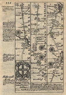
Road strip map, road map, pl.232, part of The Road from
Tinmouth to Carlisle, scale about 2 miles to 1 inch, with
sections in Northumberland and Cumberland, published by
Emanuel Bowen, St Katherines, London, 1720.
From through Haltwesell, Northumberland; past Brampton to Carlisle, Cumberland; the map also has the descriptive text for Warwick Stone Bridge, and some places in Northumberland, and the coat of arms of the deanery of Carlisle. Published in Britannia Depicta Or Ogilby Improv'd, with text by John Owen, by Emanuel Bowen from 1720 to after 1764. NB: this map is on the reverse of pl.231, item JandMN (65_231) |
||

|
Bowen 1720 | |
| map feature:- | compass rose & up is destination & rivers & relief & hillocks & county & settlements & roads & descriptive text & coat of arms | |
| wxh, sheet:- | 14.5x19.5cm | |
| wxh, map:- | 11.5x18.5cm | |
|
|
notes | |