 Otley 1818 NY20


|

|
|
|
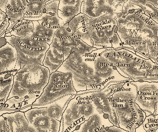
gazetteer links places may or may not be labelled on the map |
||

|
-- Angle Tarn |
|
|
|
-- Blea Tarn |
|
|
|
-- Bow Fell |
|
|
|
-- Cockley Beck |
|
|
|
-- Codale Tarn |
|
|
|
-- Dungeon Ghyll Force |
|
|
|
-- Fell Foot |
|
|
|
-- Great End -- "Gt. End" |
|
|
|
-- Great Langdale -- "LANGDALE" |
|
|
|
-- Hard Knott |
|
|
|
-- Levers Water |
|
|
|
-- Millbeck |
|
|
|
-- Pike of Stickle |
|
|
|
-- Sca Fell -- "SCAWFELL" |
|
|
|
-- Scafell Pike -- "PIKES" |
|
|
|
-- Sprinkling Tarn |
|
|
|
-- Stake Pass |
|
|
|
-- station, Scafell Pike -- "PIKES" |
|
|
|
-- Stickle Tarn |
|
|
|
-- Sty Head -- "Sty Hd." |
|
|
|
-- Styhead Tarn -- "Sty Hd." |
|
|
|
-- Taw House |
|
|
|
-- Seathwaite to Wasdale Head |
|
|
|
-- Wall End -- "Wall end" |
|
|
|
-- Wetherlam |
|
|
|
-- Wrynose Pass |
|
|
civil parishes The area roughly includes parts of parishes:- Dunnerdale-with-Seathwaite Eskdale Lakes Ulpha Nether Wasdale Coniston St John's Castlerigg and Wythburn Borrowdale |
||
|
|
||
|
|
Lakes Guides menu. | |