 Old Cumbria Gazetteer
 |
 |
|
||||||||||||||||||||||||
| track, Seathwaite to Wasdale Head | ||||||||||||||||||||||||||
| Seathwaite to Wasdale Head | ||||||||||||||||||||||||||
| Wasdale Head to Seathwaite | ||||||||||||||||||||||||||
| civil parish:- | Borrowdale (formerly Cumberland) | |||||||||||||||||||||||||
| civil parish:- | Eskdale (formerly Cumberland) | |||||||||||||||||||||||||
| county:- | Cumbria | |||||||||||||||||||||||||
| locality type:- | track route | |||||||||||||||||||||||||
| 10Km square:- | NY21 | |||||||||||||||||||||||||
| 10Km square:- | NY20 | |||||||||||||||||||||||||
| 10Km square:- | NY10 | |||||||||||||||||||||||||
|
|
||||||||||||||||||||||||||
| evidence:- | old map:- Otley 1818 |
|||||||||||||||||||||||||
| source data:- | Map, uncoloured engraving, The District of the Lakes,
Cumberland, Westmorland, and Lancashire, scale about 4 miles to
1 inch, by Jonathan Otley, 1818, engraved by J and G Menzies,
Edinburgh, Scotland, published by Jonathan Otley, Keswick,
Cumberland, et al, 1833.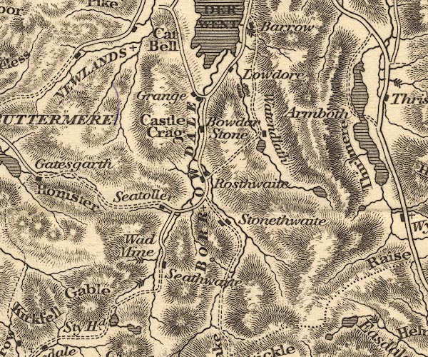 OT02NY21.jpg 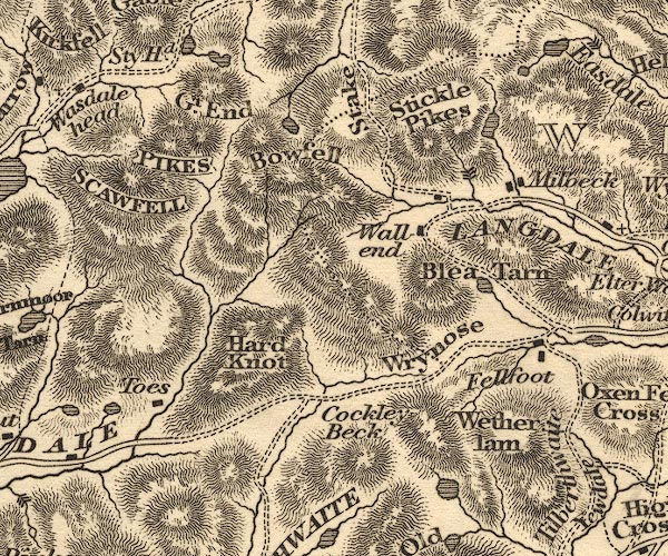 OT02NY20.jpg item:- JandMN : 48.1 Image © see bottom of page |
|||||||||||||||||||||||||
|
|
||||||||||||||||||||||||||
| evidence:- | descriptive text:- Otley 1823 (5th edn 1834) item:- viewpoint; road distances; itinerary |
|||||||||||||||||||||||||
| source data:- | Guide book, A Concise Description of the English Lakes, the
mountains in their vicinity, and the roads by which they may be
visited, with remarks on the mineralogy and geology of the
district, by Jonathan Otley, published by the author, Keswick,
Cumberland now Cumbria, by J Richardson, London, and by Arthur
Foster, Kirkby Lonsdale, Cumbria, 1823; published 1823-49,
latterly as the Descriptive Guide to the English Lakes. goto source goto sourcePage 129:- "KESWICK TO WAST WATER." goto source"... Beyond Seathwaite, the road becomes a mere track, fit only for horses accustomed to the country. A waterfall presents itself to view on the right; and after crossing a rude bridge, the ascent of the mountain is commenced by a winding path. On passing a piece of water called Sty Head Tarn, the bold and lofty crag of Great End appears on the left; and beyond it, in towering majesty, the highest of the Pikes, rendered more conspicuous by an object lately erected in the prosecution of the Trigonometrical Survey. Great Gable is close upon the right; but the grandeur of its form is better appreciated at a distance. The highest part of the road at Sty Head" goto sourcePage 130:- "is 1250 feet above the first house in the vale, and here a magnificent view presents itself: the small valley of Wasdale Head appearing as if sunk below the general level, and the sea at a distance seeming to rise in the horizon. The lake of Wast Water is not yet in sight, being hid by a projecting mountain on the left, called Lingmell. A steep zigzag track now descends on the side of Gable, down which the horses may be led; as it is neither quite safe nor agreeable to ride. Crags of the most grotesque forms overlook the road, and the side of the hill is profusely strewed with stones, in some of which garnets may be found imbedded: and in crossing the stream which issues between Gable and Kirkfell, a rock of reddish granite may be seen, where it is denudated by the waters on both sides of the road."
|
|||||||||||||||||||||||||
|
|
||||||||||||||||||||||||||
Lakes Guides menu.