 Old Cumbria Gazetteer
 |
 |
|
| Sty Head, Nether Wasdale | ||
| Sty Head | ||
| Styhead Pass | ||
| civil parish:- | Nether Wasdale (formerly Cumberland) | |
| civil parish:- | Borrowdale (formerly Cumberland) | |
| county:- | Cumbria | |
| locality type:- | pass | |
| coordinates:- | NY21910951 (etc) | |
| 1Km square:- | NY2109 | |
| 10Km square:- | NY20 | |
|
|
||
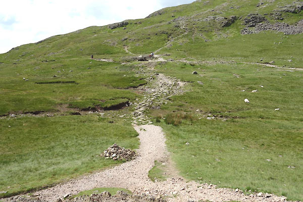
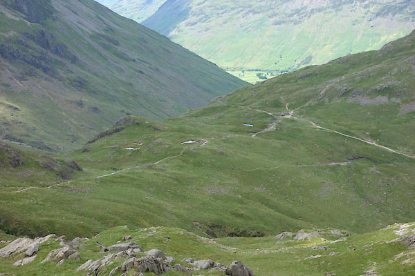 CAY96.jpg (taken 23.6.2014)  CAY98.jpg (taken 23.6.2014) |
||
|
|
||
| evidence:- | old map:- OS County Series (Cmd 74 8) placename:- Sty Head |
|
| source data:- | Maps, County Series maps of Great Britain, scales 6 and 25
inches to 1 mile, published by the Ordnance Survey, Southampton,
Hampshire, from about 1863 to 1948. |
|
|
|
||
| evidence:- | old map:- Gents Mag 1751 placename:- Sty Head |
|
| source data:- | Map, uncoloured engraving, Map of the Black Lead Mines in
Cumberland, and area, scale about 2 miles to 1 inch, by George
Smith, published in the Gentleman's Magazine, 1751.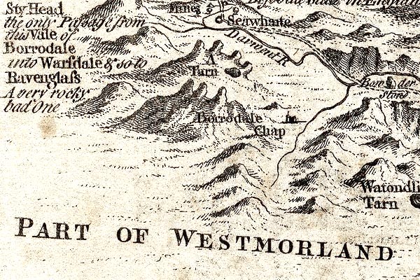 GM1309.jpg "Sty Head the only Passage from this Vale of Borrodale into Warsdale &so to Ravenglass A very rocky bad One" gap between knobbly hillocks; mountainslocks item:- JandMN : 114 Image © see bottom of page |
|
|
|
||
| evidence:- | old map:- Donald 1774 (Cmd) placename:- Stye Head |
|
| source data:- | Map, hand coloured engraving, 3x2 sheets, The County of Cumberland, scale about 1
inch to 1 mile, by Thomas Donald, engraved and published by Joseph Hodskinson, 29
Arundel Street, Strand, London, 1774. D4NY20NW.jpg "Stye Head" area item:- Carlisle Library : Map 2 Image © Carlisle Library |
|
|
|
||
| evidence:- | unlikely descriptive text:- West 1778 (11th edn 1821) placename:- Styhead |
|
| source data:- | Guide book, A Guide to the Lakes, by Thomas West, published by
William Pennington, Kendal, Cumbria once Westmorland, and in
London, 1778 to 1821. goto source goto sourceAccount of Ennerdale, late 18th century Page 293:- "..." "... As he approaches the vale of Ennerdale, ... he will find the rugged scenery of the country gradually refining; and as he winds round the foot of the Pillar, he will discover a vista, which cannot fail to strike the most indifferent observer with astonishment and pleasure." "The mountains which serve to heighten this scene, and enhance its surprise, are Sty-head, Honister-crag, Wastdale, the Pillar, and Red-pike. ..." |
|
|
|
||
| evidence:- | old map:- West 1784 map placename:- Sty Head |
|
| source data:- | Map, hand coloured engraving, A Map of the Lakes in Cumberland,
Westmorland and Lancashire, scale about 3.5 miles to 1 inch,
engraved by Paas, 53 Holborn, London, about 1784. Ws02NY20.jpg item:- Armitt Library : A1221.1 Image © see bottom of page |
|
|
|
||
| evidence:- | old text:- Green 1810 placename:- Sty Head |
|
| source data:- | Set of prints, soft ground etchings, Sixty Studies from Nature,
by William Green, Ambleside, Westmorland, drawn 1808-10,
published 1810. goto source page 80:- "..." "From Stockley Bridge, the road, which is only for foot and horse people, is up the northern side of Sprinkling, and passing Sty Head Tarn to Sty Head, displays a most stupendous view of the Wastdale mountains, having the steep and rugged sides of Lingmell and Great Gable as screens." "The road descends precipitately on" page 81:- "the side of Gable, though not in a line tolerably straight, but bearing occasionally to every point of the compass; and many a traveller will be affrighted with the prospect of rocks, which, wildly projecting from the surface of the mountain, seem ready to hurl destruction on him; at last he meets with ground somewhat less pependicular, and more polished than that he has left, for it is of soft turf; and, travelling a mile or two, arrives among the peaceful inhabitants at Wastdale Head." |
|
|
|
||
| evidence:- | old map:- Otley 1818 placename:- Sty Head |
|
| source data:- | Map, uncoloured engraving, The District of the Lakes,
Cumberland, Westmorland, and Lancashire, scale about 4 miles to
1 inch, by Jonathan Otley, 1818, engraved by J and G Menzies,
Edinburgh, Scotland, published by Jonathan Otley, Keswick,
Cumberland, et al, 1833.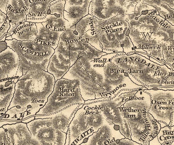 OT02NY20.jpg "Sty Hd." item:- JandMN : 48.1 Image © see bottom of page |
|
|
|
||
| evidence:- | old print:- Fielding and Walton 1821 (plate 27) placename:- Sty Head |
|
| source data:- | Print, coloured aquatint, Sty Head Tarn, Top of Sty Head, Borrowdale, Cumberland,
drawn by Theodore H A Fielding, published by R Ackermann, 101 Strand, London, 1821.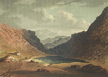 click to enlarge click to enlargeFW0127.jpg Tipped in opposite p.193 in A Picturesque Tour of the English Lakes. item:- Dove Cottage : 1993.R566.27 Image © see bottom of page |
|
|
|
||
| evidence:- | old print:- Fielding and Walton 1821 (plate 28) placename:- Sty Head |
|
| source data:- | Print, coloured aquatint, Sty Head, Nether Wasdale and Borrowdale, Cumberland, drawn
by Theodore H A Fielding, published by R Ackermann, 101 Strand, London, 1821.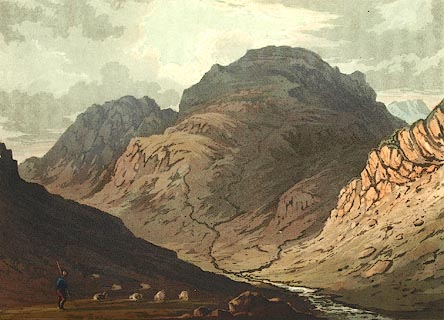 click to enlarge click to enlargeFW0128.jpg Tipped in opposite p.194 in A Picturesque Tour of the English Lakes. item:- Dove Cottage : 1993.R566.28 Image © see bottom of page |
|
|
|
||
| evidence:- | outline view:- Otley 1823 (8th edn 1849) placename:- Sty Head Pass |
|
| source data:- | Engraving, outline view of mountains, Mountains of Wast Water as seen from Nether
Wasdale, drawn by T Binns, engraved by O Jewitt, opposite p.22 of A Descriptive Guide
of the English Lakes, by Jonathan Otley, 8th edition, 1849.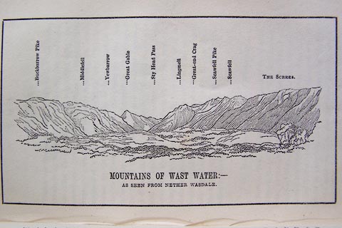 click to enlarge click to enlargeO80E13.jpg item:- Armitt Library : A1180.14 Image © see bottom of page |
|
|
|
||
| evidence:- | outline view:- Otley 1823 (5th edn 1834) placename:- Sty Head Pass |
|
| source data:- | Print, woodcut outline view, Mountains of Wast Water, by
Jonathan Otley, Keswick, Cumberland, 1830.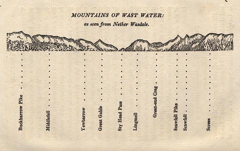 click to enlarge click to enlargeOT2E07.jpg Printed on p.31 of A Concise Description of the English Lakes, by Jonathan Otley, 5th edition, 1834. "THE MOUNTAINS OF WAST WATER: as seen from Nether Wasdale." "Buckbarrow Pike / Middlefell / Yewbarrow / Great Gable / Sty Head Pass / Lingmell / Great-end Crag / Scawfell Pike / Scawfell / Screes" item:- JandMN : 48.8 Image © see bottom of page |
|
|
|
||
| evidence:- | descriptive text:- Otley 1823 (5th edn 1834) |
|
| source data:- | Guide book, A Concise Description of the English Lakes, the
mountains in their vicinity, and the roads by which they may be
visited, with remarks on the mineralogy and geology of the
district, by Jonathan Otley, published by the author, Keswick,
Cumberland now Cumbria, by J Richardson, London, and by Arthur
Foster, Kirkby Lonsdale, Cumbria, 1823; published 1823-49,
latterly as the Descriptive Guide to the English Lakes. goto source "... The highest part of the road at Sty Head" goto sourcePage 130:- "is 1250 feet above the first house in the vale, and here a magnificent view presents itself: the small valley of Wasdale Head appearing as if sunk below the general level, and the sea at a distance seeming to rise in the horizon. The lake of Wast Water is not yet in sight, being hid by a projecting mountain on the left, called Lingmell. ..." |
|
|
|
||
| evidence:- | descriptive text:- Ford 1839 (3rd edn 1843) placename:- Stye Head |
|
| source data:- | Guide book, A Description of Scenery in the Lake District, by
Rev William Ford, published by Charles Thurnam, Carlisle, by W
Edwards, 12 Ave Maria Lane, Charles Tilt, Fleet Street, William
Smith, 113 Fleet Street, London, by Currie and Bowman,
Newcastle, by Bancks and Co, Manchester, by Oliver and Boyd,
Edinburgh, and by Sinclair, Dumfries, 1839. goto source Page 70:- "..." "... the ascent up Aaron, which leads in a zig-zag course, till it reaches the Stye Head, one thousand two hundred and fifty feet above the valley. ..." goto sourcePage 172:- "Stye Head.- From this hamlet [Wasdale Head], the tourist must ascend the road which winds along the side of Great Gable to the summit of the pass, having the Pikes of Scafell on the right." |
|
|
|
||
| evidence:- | old map:- Ford 1839 map placename:- Sty Head |
|
| source data:- | Map, uncoloured engraving, Map of the Lake District of
Cumberland, Westmoreland and Lancashire, scale about 3.5 miles
to 1 inch, published by Charles Thurnam, Carlisle, and by R
Groombridge, 5 Paternoster Row, London, 3rd edn 1843. FD02NY21.jpg "Sty Head" Between hill hachures. item:- JandMN : 100.1 Image © see bottom of page |
|
|
|
||
| evidence:- | old drawing:- Aspland 1840s-60s placename:- Sty Head |
|
| source data:- | Drawing, pencil, Sty Head, Nether Wasdale and Borrowdale, Cumberland, by Theophilus
Lindsey Aspland, 1857. click to enlarge click to enlargeAS0563.jpg "Sty Head" page number "47" item:- Armitt Library : 1958.389.63 Image © see bottom of page |
|
|
|
||
| evidence:- | perhaps old drawing:- Aspland 1840s-60s |
|
| source data:- | Drawing, pencil, perhaps Sty Head, Nether Wasdale and Borrowdale, Cumberland, by Theophilus
Lindsey Aspland, August 1852.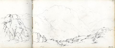 click to enlarge click to enlargeAS0326.jpg "Aug" page number "20" item:- Armitt Library : 1958.390.26 Image © see bottom of page |
|
|
|
||
| evidence:- | old drawing:- Aspland 1840s-60s placename:- Sty Head Pass |
|
| source data:- | Drawing, pencil, outline sketch, Sty Head, Nether Wasdale and Borrowdale, Cumberland,
by Theophilus Lindsey Aspland, 1852. click to enlarge click to enlargeAS0327.jpg "Sty Hd. Pass." page number "21" item:- Armitt Library : 1958.390.27 Image © see bottom of page |
|
|
|
||
| evidence:- | old text:- Martineau 1855 item:- wild boar |
|
| source data:- | Guide book, A Complete Guide to the English Lakes, by Harriet
Martineau, published by John Garnett, Windermere, Westmorland,
and by Whittaker and Co, London, 1855; published 1855-76. goto source Page 152:- "... The Sty Head Pass descends upon Seathwaite,- ... being the last dwelling at the head of the dale." "... the hill above it [Borrowdale] being called Sty Head, where the swine were wont to feed in the summer, and fall down in autumn into this dale, where they fed upon nuts and acorns. Here are large flocks of sheep; and anciently were mines of lead and copper. Here also, in a very high and perpendicular rock called Eagle Crag, is every year an eyrie or nest of eagles." ... But the traveller will find no swine near Sty Head now, summer or winter. No creature comes to drink at the tarn,- the little clear rippling lake, where the mountaineer throws himself down to rest on the bank, when heated by the ascent from the vales. ..." goto sourcePage 153:- "... The solitude is almost equally impressive whether the traveller comes up from the one dale or the other; but perhaps the most striking to him who comes from Wastdale, because he has rather more lately left the dwellings of men. He ascends from Wastdale Head, by the steep path clearly visible from below, up the side of Great Gable. At the top of the pass, the view behind is extremely fine,- the dale lying 1,000 feet below, while the precipices of Scawfell rise 2,000 feet over head. The rill from Sprinkling Tarn is close by, and it leads to this Sty Head Tarn, where the boars used to come to drink. Long after the boars were gone, the eagles came hither: and this was one of their last haunts. ..." |
|
|
|
||
| evidence:- | old text:- Martineau 1855 item:- altitude, Sty Head |
|
| source data:- | Guide book, A Complete Guide to the English Lakes, by Harriet
Martineau, published by John Garnett, Windermere, Westmorland,
and by Whittaker and Co, London, 1855; published 1855-76. goto source Page 179:- "PASSES." ": : Height above the Level of the Sea" "Sty Head : Cumberland : 1250" |
|
|
|
||
| evidence:- | old photograph:- Bell 1880s-1940s |
|
| source data:- | Photograph, black and white, Sty Head from Lingmell, Nether Wasdale and Borrowdale,
Cumberland, by Herbert Bell, photographer, Ambleside, Westmorland, 1890s.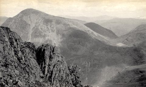 click to enlarge click to enlargeHB0778.jpg item:- Armitt Library : ALPS441 Image © see bottom of page |
|
|
|
||
| evidence:- | old photograph:- Bell 1880s-1940s |
|
| source data:- | Photograph, sepia, Lingmell from Sty Head, Nether Wasdale, Cumberland, by Herbert
Bell, photographer, Ambleside, Westmorland, 1890s.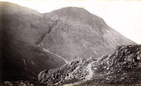 click to enlarge click to enlargeHB0650.jpg internegative at lower left:- "H. Bell." item:- Armitt Library : ALPS313 Image © see bottom of page |
|
|
|
||
| evidence:- | old photograph:- Bell 1880s-1940s |
|
| source data:- | Photograph, sepia, Sty Head, Nether Wasdale and Borrowdale, Cumberland, by Herbert
Bell, Ambleside, Westmorland, 1890s?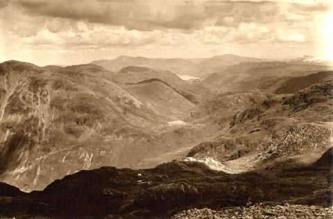 click to enlarge click to enlargeHB0344.jpg Looking across Styhead Tarn down to Derwent Water. item:- Armitt Library : ALPS710 Image © see bottom of page |
|
|
|
||
| evidence:- | old print:- Heaton Cooper 1905 (edn 1908) placename:- Styhead Pass |
|
| source data:- | Print, colour halftone, Nearing the Top of Styhead Pass, Wastdale, Cumberland, from
a watercolour painting by Alfred Heaton Cooper, published by Adam and Charles Black,
London, 2nd edn 1908.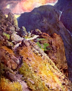 click to enlarge click to enlargeHC0135.jpg Opposite p.92 of The English Lakes, painted by Alfred Heaton Cooper, described by William T Palmer. printed at tissue opposite the print:- "NEARING THE TOP OF STYHEAD PASS, WASTDALE" printed at signed lower left:- "A HEATON COOPER" item:- JandMN : 468.35 Image © see bottom of page |
|
|
|
||
| evidence:- | old photograph:- Marr 1916 placename:- Sty Head |
|
| source data:- | Photograph, halftone print, Concorted and brecciated Volcanic Ash SE of Sty Head Tarn,
Cumberland, 1916.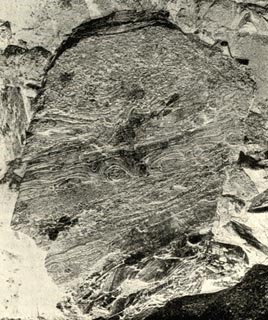 click to enlarge click to enlargeMA1205.jpg item:- JandMN : 173.13 Image © see bottom of page |
|
|
|
||
| evidence:- | outline view:- Seascale 1920s-30s placename:- Stye Head Pass |
|
| source data:- | Print, uncoloured engraving, outline view, mountains from Seascale, published by Edward
Burrow and Son, Cheltenham, Gloucestershire, 1920s-30s.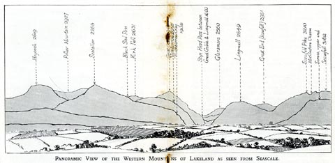 click to enlarge click to enlargeSES113.jpg "PANORAMIC VIEW OF THE WESTERN MOUNTAINS OF LAKELAND AS SEEN FROM SEASCALE." "... Stye Head Pass between Great Gable & Lingmell 1600 ..." item:- JandMN : 1079.13 Image © see bottom of page |
|
|
|
||
| evidence:- | old print:- MacBride 1922 placename:- Styhead Pass |
|
| source data:- | Print, colour, Styhead Pass, to Wastwater, by Alfred Heaton Cooper, published by Adam
and Charles Black, 4-6 Soho Square, London, 2nd edn 1928. click to enlarge click to enlargeMB0118.jpg Tipped in opposite p.113 in Wild Lakeland by MacKenzie MacBride. printed at bottom:- "STYHEAD PASS (TO WASTWATER)" signed at lower left:- "A. HEATON COOPER" item:- JandMN : 195.20 Image © see bottom of page |
|
|
|
||
| evidence:- | outline view:- Black 1856 (23rd edn 1900) placename:- Sty Head Pass |
|
| source data:- | Print, lithograph, Outline Views, Haws and Wastwater - Mountains as seen from Burn-Banks
near the Foot of Hawes Water, and Mountains as seen near Nether Wastdale at the First
Bridge on the road to Wast-Water, by J Flintoft, Keswick, Cumberland, engraved by
R Mason, Edinburgh, Lothian, about 1900.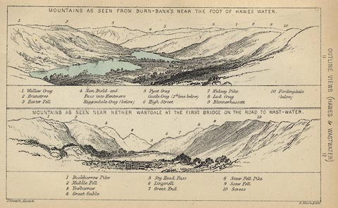 click to enlarge click to enlargeBC08E6.jpg "... 5 Sty Head Pass ..." item:- JandMN : 37.21 Image © see bottom of page |
|
|
|
||
| evidence:- | old print:- Harwood 1842 placename:- Stye Head |
|
| source data:- | Print, uncoloured engraving, Borrowdale from Stye Head, Cumberland, engraved and published
by John Harwood, 26 Fenchurch Street, London, 1846.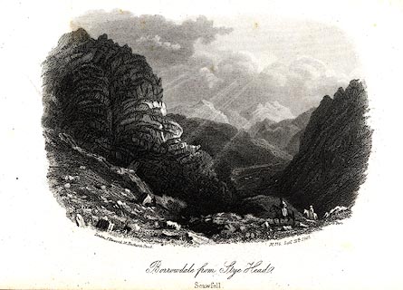 click to enlarge click to enlargeHRW217.jpg printed at bottom left, right, centre:- "London, J. Harwood, 26, Fenchurch Street. / No.715 Septr. 12th. 1846. / Borrowdale from Stye Head. / Scawfell." item:- JandMN : 166.17 Image © see bottom of page |
|
|
|
||
| evidence:- | outline view:- Black 1841 (3rd edn 1846) placename:- Sty Head Pass |
|
| source data:- | Print, engraving, outline view, Mountains as seen from Burn Banks near the Foot of
Hawes Water, and Mountains as seen near Strands in Wastdale at the First bridge on
the Road to Wast Water, by J Flintoft, Keswick, Cumberland, engraved by R Mason, Edinburgh,
Lothian, about 1846.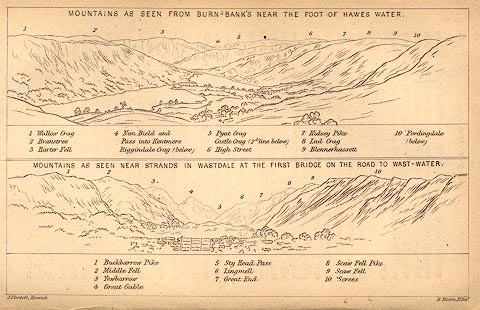 click to enlarge click to enlargeBC02E8.jpg "... 5 Sty Head Pass ..." item:- JandMN : 32.12 Image © see bottom of page |
|
|
|
||
| evidence:- | outline view:- Tattersall 1836 placename:- Stye Head item:- heron |
|
| source data:- | Print, engraving, Stye Head Tarn, Borrowdale, Cumberland, drawn by George Tattersall,
engraved by W F Topham, published by Sherwood and Co, Paternoster Row, London, about
1836.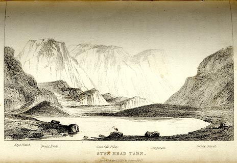 click to enlarge click to enlargeTAT131.jpg The print is captioned with mountain names and acts as an outline view. Tipped in opposite p.78 of The Lakes of England, by George Tattersall. printed at bottom:- "STYE HEAD TARN. / London Pubd. April 15th. 1836, by Sherwood &Co." printed at bottom left to right:- "Stye Head. / Great End. / Scawfell Pikes. / Lingmell. / Great Gavel." item:- Armitt Library : A1204.32 Image © see bottom of page |
|
|
|
||
| evidence:- | old print:- Rose 1832-35 (vol.1 no.72) placename:- Sty Head |
|
| source data:- | Print, uncoloured engraving, Scawfell Pikes, from Sty Head, Cumberland, drawn by Thomas
Allom, engraved by J C Bentley, published by Fisher, Son and Co, London, 1833.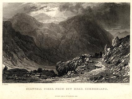 click to enlarge click to enlargePR0027.jpg vol.1 pl.72 in the set of prints, Westmorland, Cumberland, Durham and Northumberland Illustrated. printed at bottom left, right, centre:- "T. Allom. / J. C. Bentley. / SCAWFELL PIKES, FROM STY HEAD, CUMBERLAND. / FISHER, SON &CO. LONDON, 1833." item:- Dove Cottage : 2008.107.27 Image © see bottom of page |
|
|
|
||
 CAY97.jpg (taken 23.6.2014) 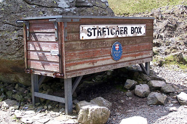 BQO15.jpg Stretcher box, Mountain Rescue kit. (taken 12.5.2009) 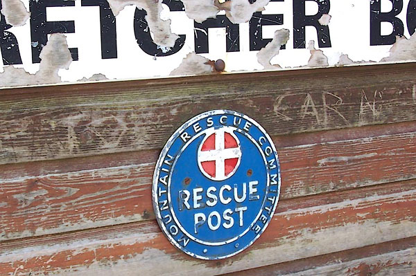 BQO16.jpg Stretcher box, Mountain Rescue kit. (taken 12.5.2009) |
||
|
|
||
| hearsay:- |
Edmund Bogg commented, 1898:- |
|
| "There is just now a strong agitation for the construction of a road over this lonely
pass. For my part I fail to see who will benefit by this desecration except perhaps
a few innkeepers." |
||
| Bogg 1898 |
||
|
|
||
| hearsay:- |
A cloud called the Borrowdale Sop sometimes forms over Sty Head. It is a weather sign:
moving towards Great Langdale it is a sign of rain; moving to the east of Borrowdale,
a sign of fair. |
|
|
|
||
Lakes Guides menu.