 Old Cumbria Gazetteer
 |
 |
|
||||||||||||||||||||||||||||||||||||||||||||||||||||||||
| viewpoint, Scafell Pike | ||||||||||||||||||||||||||||||||||||||||||||||||||||||||||
| Scafell Pike viewpoint | ||||||||||||||||||||||||||||||||||||||||||||||||||||||||||
| site name:- | Scafell Pike | |||||||||||||||||||||||||||||||||||||||||||||||||||||||||
| civil parish:- | Eskdale (formerly Cumberland) | |||||||||||||||||||||||||||||||||||||||||||||||||||||||||
| county:- | Cumbria | |||||||||||||||||||||||||||||||||||||||||||||||||||||||||
| locality type:- | viewpoint | |||||||||||||||||||||||||||||||||||||||||||||||||||||||||
| coordinates:- | NY21530722 (about) | |||||||||||||||||||||||||||||||||||||||||||||||||||||||||
| 1Km square:- | NY2107 | |||||||||||||||||||||||||||||||||||||||||||||||||||||||||
| 10Km square:- | NY20 | |||||||||||||||||||||||||||||||||||||||||||||||||||||||||
| altitude:- | 3205 feet | |||||||||||||||||||||||||||||||||||||||||||||||||||||||||
| altitude:- | 977m | |||||||||||||||||||||||||||||||||||||||||||||||||||||||||
|
|
||||||||||||||||||||||||||||||||||||||||||||||||||||||||||
| evidence:- | old map:- Otley 1818 placename:- Pikes |
|||||||||||||||||||||||||||||||||||||||||||||||||||||||||
| source data:- | Map, uncoloured engraving, The District of the Lakes,
Cumberland, Westmorland, and Lancashire, scale about 4 miles to
1 inch, by Jonathan Otley, 1818, engraved by J and G Menzies,
Edinburgh, Scotland, published by Jonathan Otley, Keswick,
Cumberland, et al, 1833.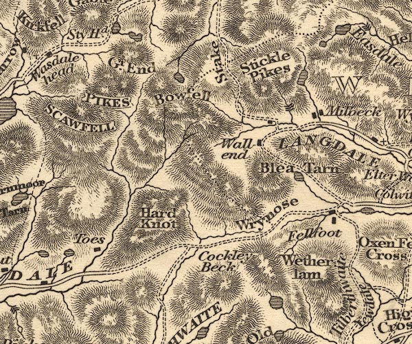 OT02NY20.jpg "PIKES" item:- JandMN : 48.1 Image © see bottom of page |
|||||||||||||||||||||||||||||||||||||||||||||||||||||||||
|
|
||||||||||||||||||||||||||||||||||||||||||||||||||||||||||
| evidence:- | descriptive text:- Otley 1823 (5th edn 1834) placename:- Pikes, The item:- latitude; longitude; lat and long |
|||||||||||||||||||||||||||||||||||||||||||||||||||||||||
| source data:- | Guide book, A Concise Description of the English Lakes, the
mountains in their vicinity, and the roads by which they may be
visited, with remarks on the mineralogy and geology of the
district, by Jonathan Otley, published by the author, Keswick,
Cumberland now Cumbria, by J Richardson, London, and by Arthur
Foster, Kirkby Lonsdale, Cumbria, 1823; published 1823-49,
latterly as the Descriptive Guide to the English Lakes. goto source goto sourcePage 67:- "..." "As may be expected from its altitude, the prospect on every side is extensive. We overlook an immense assemblage of mountains, which to particularize would be thought tedious; and a mere list of their names could convey little information. The near ones exhibit the stern grandeur of their rocky summits; but their general arrangement is not so splendid, nor their forms so stately, as when viewed from Helvellyn, or from the ascent to Skiddaw; and there is a deficiency of the rich lowland views that may be had from the latter mountain." "Satiated by mountain scenery, the eye is instinctively turned towards the sea, which opens to a great extent, and shews the various indentations of the Lancashire and Cumberland coasts; with the isle" goto sourcePage 68:- "of Walney stretching from the bay of Morecambe to the estuary of the Duddon. The top of Ingleborough may be seen in the distance; but it requires a very clear atmosphere to discern the mountains of North Wales, which stretch out to the right of Black Combe. The Isle of Man is frequently visible; and, when the surface of the sea is covered with a thin film of vapour, the effect at first sight is curious; the island appearing more like an object in the clouds than one seated in the water. The fells of Coniston exclude the view of Lancaster sands; but an opening, between the Old Man and Dow Crag, directs to the church and castle of Lancaster. Some portions of Scotland appear on the right and left of the Ennerdale and Derwent Fells; and we are just permitted to see a part of the lake of Windermere, between Low Wood Inn and Bowness; also the eastern side of Derwentwater, and a part of Wast Water, with Devoke Water, Sty-head Tarn, and a small mountain tarn above Borrowdale." "From a point a little to the southward, we can take a peep into the head of the vale of Eskdale, far below us; and beyond it, a single habitation in Seathwaite, near the rise of the Duddon. Passing towards Great-end a portion of Crummock Lake comes in sight; and from Great-end, and Esk Hause, there are more open views towards the head of Windermere, and the lake of Derwentwater." goto sourcePage 78:- "STATION I.- SCAWFELL highest point, THE PIKES." "Latitude 54° 27′ 24″ N. Longitude 3° 12′W. Height 3160 feet."
|
|||||||||||||||||||||||||||||||||||||||||||||||||||||||||
|
|
||||||||||||||||||||||||||||||||||||||||||||||||||||||||||
| evidence:- | old photograph:- Bell 1880s-1940s |
|||||||||||||||||||||||||||||||||||||||||||||||||||||||||
| source data:- | Photograph, black and white, view from Scafell Pike, Eskdale, Cumberland, by Herbert
Bell, photographer, Ambleside, Westmorland, 1890s.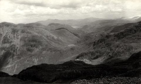 click to enlarge click to enlargeHB0710.jpg stamped on reverse:- "HERBERT BELL / Photographer / AMBLESIDE" item:- Armitt Library : ALPS374 Image © see bottom of page |
|||||||||||||||||||||||||||||||||||||||||||||||||||||||||
|
|
||||||||||||||||||||||||||||||||||||||||||||||||||||||||||
Lakes Guides menu.