 Old Cumbria Gazetteer
 |
 |
|
| Stake Pass, Borrowdale | ||
| Stake Pass | ||
| civil parish:- | Borrowdale (formerly Cumberland) | |
| civil parish:- | Lakes (formerly Westmorland) | |
| county:- | Cumbria | |
| locality type:- | pass | |
| coordinates:- | NY26530869 (pile of stones) | |
| 1Km square:- | NY2608 | |
| 10Km square:- | NY20 | |
| altitude:- | 1575 feet | |
| altitude:- | 480m | |
|
|
||
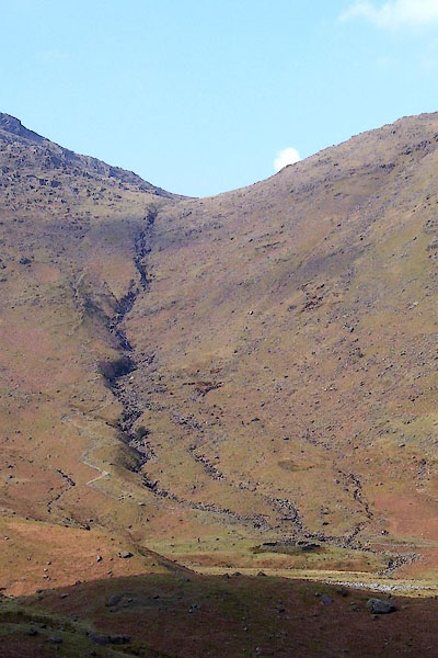 BNL57.jpg Stake Gill towards Stake Pass, from SW. (taken 26.3.2007) 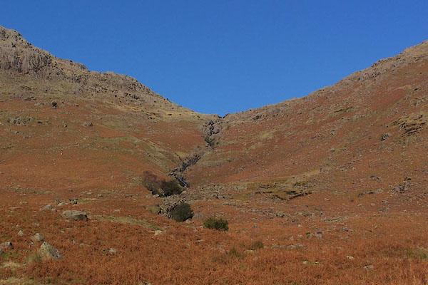 BRW48.jpg (taken 11.11.2009) |
||
|
|
||
| evidence:- | old map:- OS County Series (Wmd 18 13) placename:- Stake Pass |
|
| source data:- | Maps, County Series maps of Great Britain, scales 6 and 25
inches to 1 mile, published by the Ordnance Survey, Southampton,
Hampshire, from about 1863 to 1948. OS County Series (Wmd 25 1) |
|
|
|
||
| evidence:- | descriptive text:- West 1778 (11th edn 1821) placename:- Stake of Borrowdale |
|
| source data:- | Guide book, A Guide to the Lakes, by Thomas West, published by
William Pennington, Kendal, Cumbria once Westmorland, and in
London, 1778 to 1821. goto source goto sourcePage 101:- "Whoever chooses an Alpine journey of a very extraordinary nature, may return thro' Borrowdale to Ambleside, or Hawkshead.- A guide will be necessary from Rosthwaite, over the Stake of Borrowdale (a steep mountain so called) to Langdale Chapel. This ride is the wildest that can be imagined, for the space of eight miles [1]. Above the culti-" "[1] Every part of nature has something to recommend it to the observation of the susceptible and ingenious. A walk or ride, on the summits of mountains, will afford a species of ideas, which, though often neither of the social or luxuriant kind, will, nevertheless, greatly affect and entertain. The large unvariegated features of these hills, their elevation, and even their desolate appearance, are all sources of the sublime. ..." goto sourcePage 102:- "[culti]vated tract the dale narrows, but the skirts of the mountains are covered with the sweetest" goto sourcePage 103:- "verdure, and have once waved with aged wood. Many large roots still remain, with some scattered trees." "Just where the road begins to ascend the Stake, are said to be the remains of a bloomery, close by the water-fall on the left; but no tradition relates at what time it was last worked. This I could never verify from any visible remains. The mineral was found in the mountain, and the wood used in smelting had covered their steep sides. The masses of iron found on Castle-crag were probably smelted here. Cataracts and water-falls abound on all sides. A succession of water-falls will meet you on the ascent up the Stake, and others will accompany you down the most dreadful descent in Langdale. The scenes on the Borrowdale side are in part sylvan" goto sourcePage 104:- "and pastoral, on the side of Langdale entirely rocky. The Stake exhibits a miniature of very bad Alpine road, across a mountain, just not perpendicular, and about five miles over. The road makes many traverses so close, that at every flexture it seems almost to return into itself, and such as are advancing in different traverses, appear to go different ways. In descending the Stake, on the Langdale side, a cataract accompanies you on the left, with all the horrors of a precipice. Langdale-pike, called Pike-a-Stickle, and Steel-pike, is an accessible pyramidal rock, and commands the whole. Here nature seems to have discharged all her useless load of matter and rock, when form was first impressed on chaos. Pavey-ark is a hanging rock 600 feet in height, and under it is Stickle-tarn, a large bason of water, formed in the bosom of the rock, and which pours down in a cataract at Mill-beck. Below this, White-gill-crag opens to the centre, a dreadful yawning fissure. Beyond Langdale chapel the vale becomes more pleasing, and the road is good to Ambleside or Hawkshead, by Scalewith-bridge." |
|
|
|
||
| evidence:- | old map:- West 1784 map placename:- Stake |
|
| source data:- | Map, hand coloured engraving, A Map of the Lakes in Cumberland,
Westmorland and Lancashire, scale about 3.5 miles to 1 inch,
engraved by Paas, 53 Holborn, London, about 1784.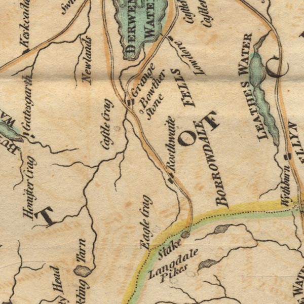 Ws02NY21.jpg item:- Armitt Library : A1221.1 Image © see bottom of page |
|
|
|
||
| evidence:- | old map:- Otley 1818 placename:- Stake |
|
| source data:- | Map, uncoloured engraving, The District of the Lakes,
Cumberland, Westmorland, and Lancashire, scale about 4 miles to
1 inch, by Jonathan Otley, 1818, engraved by J and G Menzies,
Edinburgh, Scotland, published by Jonathan Otley, Keswick,
Cumberland, et al, 1833.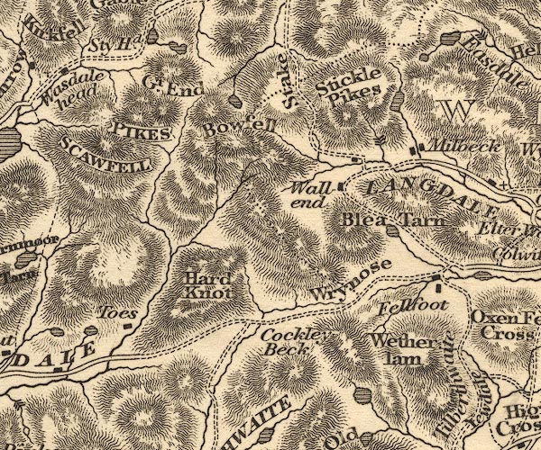 OT02NY20.jpg item:- JandMN : 48.1 Image © see bottom of page |
|
|
|
||
| evidence:- | old map:- Garnett 1850s-60s H placename:- Stake, The |
|
| source data:- | Map of the English Lakes, in Cumberland, Westmorland and
Lancashire, scale about 3.5 miles to 1 inch, published by John
Garnett, Windermere, Westmorland, 1850s-60s.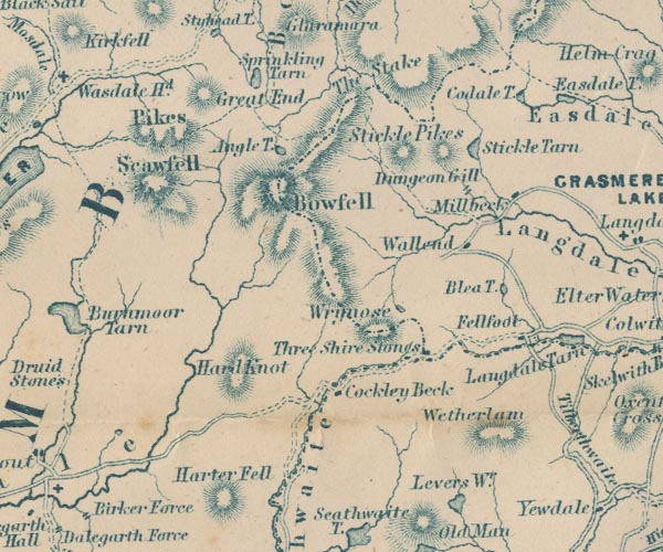 GAR2NY20.jpg "The Stake" pass, between hachures item:- JandMN : 82.1 Image © see bottom of page |
|
|
|
||
| evidence:- | old text:- Martineau 1855 |
|
| source data:- | Guide book, A Complete Guide to the English Lakes, by Harriet
Martineau, published by John Garnett, Windermere, Westmorland,
and by Whittaker and Co, London, 1855; published 1855-76. goto source Page 145:- "..." "The top of the Stake Pass is five miles and a-half from Rosthwaite. The last house,- Stonethwaite,- is left behind at the end of a mile. The path follows, and at length crosses, the stream, which is the infant Derwent,- finding its way down from Angle Tarn, lying high up in a recess of Bowfell. The rocky mass of Eagle Crag rises on the left; and further on, the curious stone called Black Cap. At the top of the Stake, the guide (who may be had from the inn at Rosthwaite) will point out the great summits,- the Scawfell Pikes, Bowfell, Hanging Knotts and Great Gable. Half a-mile of moorland leads to the descent on the Langdale side; a zigzag path which keeps near the stream that dashes down into Langdale. The" goto sourcePage 146:- "traveller is under the shadow of Bowfell now, and in the very centre of the mountains. Four miles from the top of the Stake will bring him down to Langdale Head; and two miles more, to the farmhouse of Milbeck." |
|
|
|
||
| evidence:- | old print:- Barber and Atkinson 1927 placename:- Stake Pass |
|
| source data:- | Print, halftone photograph, Top of Stake Pass, Borrowdale, Cumberland, by E H Atkinson,
published by James Atkinson, Caxton Printing Works, Ulverston, Lancashire, 1928.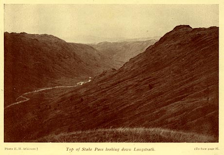 click to enlarge click to enlargeAK0411.jpg Tipped in opposite p.57 of Lakeland Passes, by John B Barber and George Atkinson, 1927, 3rd edn 1928. printed at bottom:- "Photo E. H. Atkinson.) Top of Stake Pass looking down Langstrath. (To face plage 57." item:- JandMN : 350.12 Image © see bottom of page |
|
|
|
||
| evidence:- | old print:- MacBride 1922 placename:- Stake Pass |
|
| source data:- | Print, colour, Stake Pass and Bowfell, by Alfred Heaton Cooper, published by Adam
and Charles Black, 4-6 Soho Square, London, 2nd edn 1928.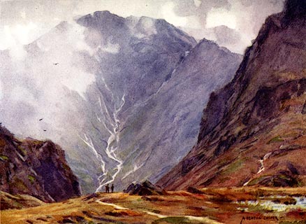 click to enlarge click to enlargeMB0109.jpg Tipped in opposite p.44 in Wild Lakeland by MacKenzie MacBride. printed at bottom:- "STAKE PASS AND BOWFELL" signed at lower right:- "A. HEATON COOPER" item:- JandMN : 195.11 Image © see bottom of page |
|
|
|
||
| evidence:- | old print:- Garnett 1850s-60s A |
|
| source data:- | Print, uncoloured engraving, Head of Langdale, from the Blea
Tarn Road, published by John Garnett, Windermere, Westmorland,
and by Simpkin, Marshall and Co, London, 2nd edn 1860s?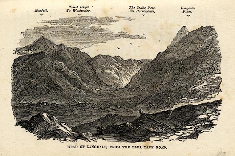 click to enlarge click to enlargeGAR6E2.jpg item:- JandMN : 149.3 Image © see bottom of page |
|
|
|
||
Lakes Guides menu.