 Otley 1818 NY11


|

|
|
|
gazetteer links places may or may not be labelled on the map |
||

|
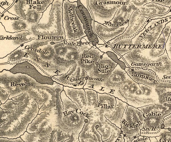
-- Buttermere -- "BUTTERMERE" |
|
|
|
-- Crummock Water |
|
|
|
-- Ennerdale Water |
|
|
|
-- Ennerdale -- "ENNERDALE" |
|
|
|
-- Floutern Tarn |
|
|
|
-- Gatesgarth |
|
|
|
-- Gillerthwaite |
|
|
|
-- Haycock |
|
|
|
-- High Stile |
|
|
|
-- Honister Crag |
|
|
|
-- Kirk Fell |
|
|
|
-- Mellbreak |
|
|
|
-- Pillar |
|
|
|
-- Red Pike |
|
|
|
-- Scale Force |
|
|
|
-- Scoat Tarn |
|
|
|
-- Whiteless Pike |
|
|
civil parishes The area roughly includes parts of parishes:- Lamplugh Nether Wasdale Ennerdale and Kinniside Buttermere Loweswater Above Derwent |
||
|
|
||
|
|
Lakes Guides menu. | |