 Old Cumbria Gazetteer
 |
 |
|
| Honister Crag, Buttermere | ||
| Honister Crag | ||
| locality:- | Seatoller Fell | |
| civil parish:- | Buttermere (formerly Cumberland) | |
| county:- | Cumbria | |
| locality type:- | rocks | |
| coordinates:- | NY21131421 (etc) | |
| 1Km square:- | NY2114 | |
| 10Km square:- | NY21 | |
|
|
||
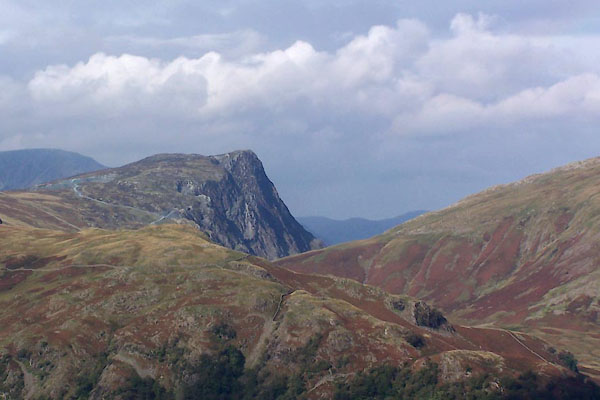 BTO73.jpg From Rosthwaite Fell. (taken 22.9.2010) 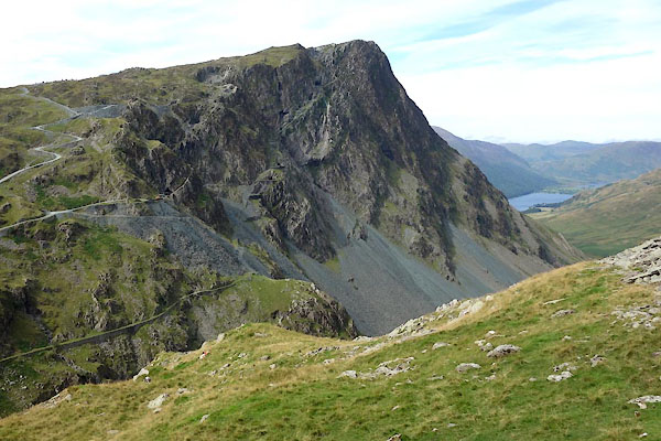 BZG43.jpg (taken 6.9.2013) |
||
|
|
||
| evidence:- | old map:- Donald 1774 (Cmd) placename:- Honistar Crag |
|
| source data:- | Map, hand coloured engraving, 3x2 sheets, The County of Cumberland, scale about 1
inch to 1 mile, by Thomas Donald, engraved and published by Joseph Hodskinson, 29
Arundel Street, Strand, London, 1774. D4NY21SW.jpg "Honistar Crag" hill hachuring; a hill or mountain item:- Carlisle Library : Map 2 Image © Carlisle Library |
|
|
|
||
| evidence:- | descriptive text:- West 1778 (11th edn 1821) |
|
| source data:- | Guide book, A Guide to the Lakes, by Thomas West, published by
William Pennington, Kendal, Cumbria once Westmorland, and in
London, 1778 to 1821. goto source goto sourceAccount of Ennerdale, late 18th century Page 293:- "..." "... As he approaches the vale of Ennerdale, ... he will find the rugged scenery of the country gradually refining; and as he winds round the foot of the Pillar, he will discover a vista, which cannot fail to strike the most indifferent observer with astonishment and pleasure." "The mountains which serve to heighten this scene, and enhance its surprise, are Sty-head, Honister-crag, Wastdale, the Pillar, and Red-pike. ..." |
|
|
|
||
| evidence:- | old map:- West 1784 map placename:- Honister Crag |
|
| source data:- | Map, hand coloured engraving, A Map of the Lakes in Cumberland,
Westmorland and Lancashire, scale about 3.5 miles to 1 inch,
engraved by Paas, 53 Holborn, London, about 1784. Ws02NY11.jpg item:- Armitt Library : A1221.1 Image © see bottom of page |
|
|
|
||
| evidence:- | old text:- Green 1810 placename:- Honister Crag |
|
| source data:- | Set of prints, soft ground etchings, Sixty Studies from Nature,
by William Green, Ambleside, Westmorland, drawn 1808-10,
published 1810. goto source page 68:- "... Honister Crag, at the Borrowdale end of the valley [Buttermere], is a steep high rock, from the side of which is got an abundance of slate. ..." |
|
|
|
||
| evidence:- | old print:- Green 1814 (plate 38) placename:- Honister Crag |
|
| source data:- | Print, tinted soft ground etching, Honister Crag, Buttermere, Cumberland, by William
Green, Ambleside, Westmorland, 1814.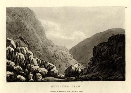 click to enlarge click to enlargeGN1038.jpg Plate 38 in Sixty Small Prints. printed at top right:- "38" printed at bottom:- "HONISTER CRAG. / Published at Ambleside Augst. 1, 1814, by Wm. Green." item:- Armitt Library : A6653.38 Image © see bottom of page |
|
|
|
||
| evidence:- | old print:- Green 1814 (plate 38) placename:- Honister Crag |
|
| source data:- | Print, uncoloured soft ground etching, Honister Crag, Buttermere, Cumberland, by William
Green, Ambleside, Westmorland, 1814.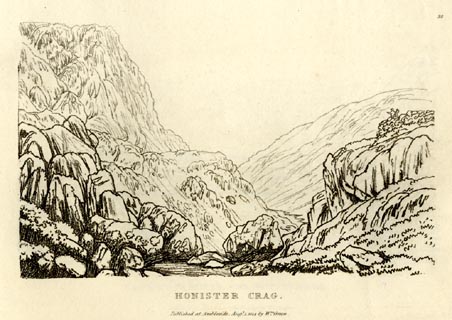 click to enlarge click to enlargeGN0938.jpg Plate 38 in Sixty Small Prints. printed at top right:- "38" printed at bottom:- "HONISTER CRAG. / Published at Ambleside Augst. 1, 1814, by Wm. Green." item:- Armitt Library : A6656.38 Image © see bottom of page |
|
|
|
||
| evidence:- | old text:- Green 1814 placename:- Honister Crag item:- slate |
|
| source data:- | Set of prints, soft ground etchings, Sixty Small Prints, with
text, A Description of a Series of Sixty Small Prints, by
William Green, Ambleside, Westmorland, 1814. goto source page 20:- "..." "HONISTER CRAG." "..." "This view [plate 38] of Honister Crag is from the stream which passes from the head of Gatesgarthdale to Buttermere, and below the road a little after its having left the summit of the pass. Honister Crag, almost perpendicular, seems, from the bottom of the valley, to overhang its base, and is a precipice of extraordinary magnificence: but from this rugged front is derived a slate as smooth and valuable as any other in the island." |
|
|
|
||
| evidence:- | old print with text:- Farington 1816 placename:- Honister Crag |
|
| source data:- | Print, uncoloured engraving and descriptive text, Honister Crag, Buttermere, Cumberland,
drawn by Joseph Farington, engraved by Samuel Middiman, published by T Cadell and
W Davies, Strand, London, 1815.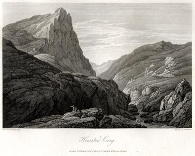 click to enlarge click to enlargeFA0412.jpg printed, bottom left, right, centre "Drawn by J. Farington R.A. / Engraved by S. Middiman. / Honister Crag. / London Published Septr. 15, 1815, by T. Cadell &W. Davies, Strand." Descriptive text:- "HONISTER CRAG, which has been mentioned in the preceding description, forms the termination of those rugged mountains which circumscribe Crummock Water and Buttermere. It is reputed to be the steepest rock in the whole country, and of the finest form; and is said to resemble the Table Mountains in the East Indies, each of which has a fortress on its summit. The top of this Crag commands a most beautiful view of the Lakes below, and the heaps of mountains all around. Here is a slate quarry, which fails not to attract the attention of tourists." "..." item:- Armitt Library : A6666.12 Image © see bottom of page |
|
|
|
||
| evidence:- | old map:- Otley 1818 placename:- Honister |
|
| source data:- | Map, uncoloured engraving, The District of the Lakes,
Cumberland, Westmorland, and Lancashire, scale about 4 miles to
1 inch, by Jonathan Otley, 1818, engraved by J and G Menzies,
Edinburgh, Scotland, published by Jonathan Otley, Keswick,
Cumberland, et al, 1833. OT02NY11.jpg item:- JandMN : 48.1 Image © see bottom of page |
|
|
|
||
| evidence:- | outline view:- Otley 1823 (4th edn 1830) placename:- Honister |
|
| source data:- | Print, engraving, outline view, Some of the Western Mountains as seen from Helvellyn,
published by Jonathan Otley, Keswick, Cumberland et al, 1830.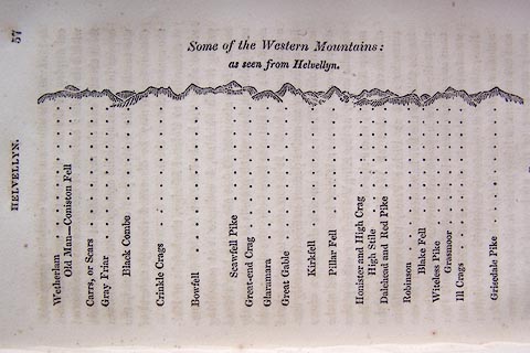 click to enlarge click to enlargeO75E02.jpg p.57 in A Concise Description of the English Lakes, by Jonathan Otley, 4th edition, 1830. "Some of the Western Mountains: / as seen from Helvellyn." "Wetherlam / Old Man - Coniston Fell / Carrs, or Scars / Gray Friar / Black Combe / Crinkle Crags / Bowfell / Scawfell Pike / Great-end Crag / Glaramara / Great Gable / Kirkfell / Pillar Fell / Honister and High Crag / High Stile / Dalehead and Red Pike / Robinson / Blake Fell / Witeless Pike / Grasmoor / Ill Crags / Grisedale Pike" item:- Armitt Library : A1175.3 Image © see bottom of page |
|
|
|
||
| evidence:- | outline view:- Otley 1823 (8th edn 1849) placename:- Honister |
|
| source data:- | Engraving, outline view of mountains, A Group of Mountains seen from Helvellyn, looking
towards the South West, drawn by T Binns, engraved by O Jewitt, opposite p.50 of A
Descriptive Guide of the English Lakes, by Jonathan Otley, 8th edition, 1849.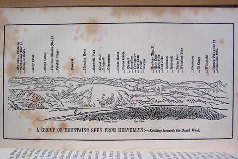 click to enlarge click to enlargeO80E17.jpg item:- Armitt Library : A1180.18 Image © see bottom of page |
|
|
|
||
| evidence:- | outline view:- Otley 1823 (5th edn 1834) placename:- Honister |
|
| source data:- | Print, woodcut outline view, A Group of Mountains, seen from
Helvellyn, by Jonathan Otley, Keswick, Cumberland, 1830.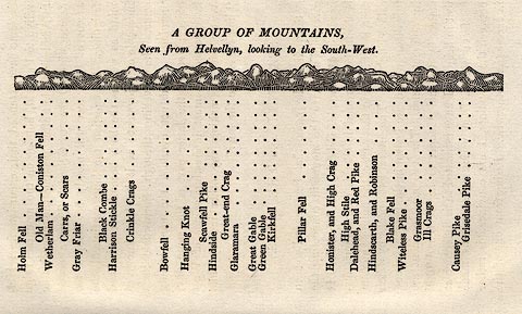 click to enlarge click to enlargeOT2E09.jpg Printed on p.63 of A Concise Description of the English Lakes, by Jonathan Otley, 5th edition, 1834. "A GROUP OF MOUNTAINS, Seen from Helvellyn, looking to the South-West." "Holm Fell / Old Man - Coniston Fell / Wetherlam / Carrs, or Scars / Gray Friar / Black Combe / Harrison Stickle / Crinkle Crags / Bowfell / Hanging Knot / Scawfell Pike / Hindside / Great-end Crag / Glaramara / Great Gable / Green Gable / Kirkfell / Pillar Fell / Honister, and High Crag / High Stile / Dalehead, and Red Pike / Hindscarth, and Robinson / Blake Fell / Witeless Pike / Grasmoor / Ill Crags / Causey Pike / Grisedale Pike" item:- JandMN : 48.10 Image © see bottom of page |
|
|
|
||
| evidence:- | descriptive text:- Otley 1823 (5th edn 1834) placename:- Honister item:- geology |
|
| source data:- | Guide book, A Concise Description of the English Lakes, the
mountains in their vicinity, and the roads by which they may be
visited, with remarks on the mineralogy and geology of the
district, by Jonathan Otley, published by the author, Keswick,
Cumberland now Cumbria, by J Richardson, London, and by Arthur
Foster, Kirkby Lonsdale, Cumbria, 1823; published 1823-49,
latterly as the Descriptive Guide to the English Lakes. goto source "... In passing the hause, (which rises 800 feet above the level of Derwent Lake,) Honister Crag in majestic grandeur is presented to the view; ..." goto sourcePage 126:- "... [Gatescarth dale] is a narrow valley strewed with large blocks of stone, fallen from the rocks above; and solemnly shaded by the lofty Honister, which towers to the height of 1700 feet above the valley at its foot. ..." "..." goto sourcePage 156:- "... An amygdaloid rock, containing nodules of calcareous spar, and sometimes of agate, opal or calcedony, is met with in several places; as near Honister Crag ..." |
|
|
|
||
| evidence:- | descriptive text:- Ford 1839 (3rd edn 1843) placename:- Honistar Crag |
|
| source data:- | Guide book, A Description of Scenery in the Lake District, by
Rev William Ford, published by Charles Thurnam, Carlisle, by W
Edwards, 12 Ave Maria Lane, Charles Tilt, Fleet Street, William
Smith, 113 Fleet Street, London, by Currie and Bowman,
Newcastle, by Bancks and Co, Manchester, by Oliver and Boyd,
Edinburgh, and by Sinclair, Dumfries, 1839. goto source Page 88:- "... The top of this road, which is not passable for carriages, is eight hundred and eighty feet above the Derwent." "On the right is Yew Crag Quarry: on the left that stupendous precipice, Honistar Crag, rises sheer out of the valley to the height of one thousand six hundred feet, on which are extensive blue-slate quarries. ..." |
|
|
|
||
| evidence:- | old map:- Garnett 1850s-60s H placename:- Honister |
|
| source data:- | Map of the English Lakes, in Cumberland, Westmorland and
Lancashire, scale about 3.5 miles to 1 inch, published by John
Garnett, Windermere, Westmorland, 1850s-60s. GAR2NY21.jpg "Honister" hill hachuring item:- JandMN : 82.1 Image © see bottom of page |
|
|
|
||
| evidence:- | outline view:- Martineau 1855 |
|
| source data:- | Print, engraving, outline view, Mountains seen from Lanthwaite Wood Crummock Water,
drawn by L Aspland, engraved by W Banks, Edinburgh, published by John Garnett, Windermere,
Westmorland, and by Whittaker and Co, London, 1855.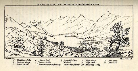 click to enlarge click to enlargeMNU113.jpg Opposite p.84 in A Complete Guide to the English Lakes, by Harriet Martineau. The view is captioned, numbers referring to mountains in the image:- "1 Whiteless Pike, 2 Honister Crag, 3 Green Gable, 4 Great End, 5 Great Gable / Rannerdale Knott (beneath), 6 Scawfell Pike, 7 Kirkfell / Scarf Gap (below), 8 High Crag, 9 High Stile, 10 Bleaberry Crag, 11 Red Pike, 12 Melbreak." "MOUNTAINS SEEN FROM LANTHWAITE WOOD CRUMMOCK WATER." "L Aspland Delt. / W Banks Sc Edinr." item:- Armitt Library : A1159.13 Image © see bottom of page |
|
|
|
||
| evidence:- | old print:- Martineau 1855 |
|
| source data:- | Print, engraving, Honister Crag from the Quarry Road to Yew Crag, drawn by L Aspland,
engraved by W Banks, Edinburgh, published by John Garnett, Windermere, Westmorland,
and by Whittaker and Co, London, 1855.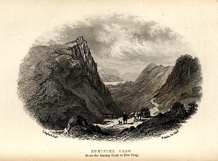 click to enlarge click to enlargeMNU117.jpg Opposite p.133 in A Complete Guide to the English Lakes, by Harriet Martineau. "L Aspland Delt. / W Banks Sc Edinr. / HONISTER CRAG / from the Quarry Road to Yew Crag." item:- Armitt Library : A1159.17 Image © see bottom of page |
|
|
|
||
| evidence:- | old text:- Martineau 1855 item:- altitude, Honister Crag |
|
| source data:- | Guide book, A Complete Guide to the English Lakes, by Harriet
Martineau, published by John Garnett, Windermere, Westmorland,
and by Whittaker and Co, London, 1855; published 1855-76. goto source Page 179:- "A TABLE OF THE HEIGHTS OF MOUNTAINS IN THE COUNTIES OF CUMBERLAND, WESTMORLAND, AND LANCASHIRE." "No. : Names of Mountains. : Counties. : Height in Feet above the Sea Level." "23 : Honister Crag : Cumberland : 1700" |
|
|
|
||
| evidence:- | old print:- Walton 1876 placename:- Honister Crag item:- snow |
|
| source data:- | Print, colour lithograph, Honister Crag, Winter, Buttermere, Cumberland, from a painting
by Elijah Walton, published by W M Thompson, 20 Cockspur Street, Pall Mall, and Burlington
Gallery, Piccadilly, London, 1876.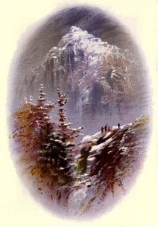 click to enlarge click to enlargeWLT304.jpg Plate 4 in English Lake Scenery, with a description by T G Bonney. item:- JandMN : 469.4 Image © see bottom of page |
|
|
|
||
| evidence:- | old print:- Nelson 1853 (edn 1880s) placename:- Honister Crag |
|
| source data:- | Print, chromolithograph, Honister Crag, Buttermere, Cumberland, published by Thomas
Nelson and Sons, London, 1880s?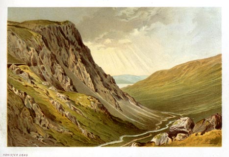 click to enlarge click to enlargeNS0333.jpg At the end of Views of the English Lakes, and Tourists Guide to the English Lakes. printed at bottom:- "HONISTER CRAG" item:- JandMN : 474.34 Image © see bottom of page |
|
|
|
||
| evidence:- | old photograph:- Bell 1880s-1940s item:- scree |
|
| source data:- | Photograph, black and white, Honister Pass and Honister Crag, Buttermere, Cumberland,
by Herbert Bell, photographer, Ambleside, Westmorland, 1890s.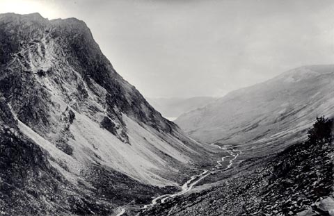 click to enlarge click to enlargeHB0875.jpg internegative at lower left:- "H. Bell" stamped at reverse:- "HERBERT BELL / Photographer / AMBLESIDE" item:- Armitt Library : ALPS546 Image © see bottom of page |
|
|
|
||
| evidence:- | old photograph:- Bell 1880s-1940s |
|
| source data:- | Photograph, sepia, Buttermere lake and Honister Crag, Buttermere, Cumberland, by Herbert
Bell, photographer, Ambleside, Westmorland, 1890s.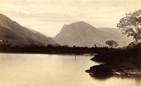 click to enlarge click to enlargeHB0611.jpg item:- Armitt Library : ALPS271 Image © see bottom of page |
|
|
|
||
| evidence:- | old photograph:- Bell 1880s-1940s item:- scree |
|
| source data:- | Photograph, black and white, Honister Crag, Buttermere, Cumberland, by Herbert Bell,
Ambleside, Westmorland, 1890s.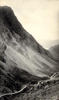 click to enlarge click to enlargeHB0463.jpg internegative at lower right:- "H. Bell" item:- Armitt Library : ALPS122 Image © see bottom of page |
|
|
|
||
| evidence:- | old print:- Philip/Wilson 1890s |
|
| source data:- | Print, engraving, Honister Crag and Pass, published by George
Philip and Son, London, Philip, Son and Nephew, Liverpool,
Lancashire, and Titus Wilson, Kendal, Westmorland, about 1895.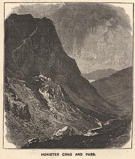 click to enlarge click to enlargePW1E29.jpg "HONISTER CRAG AND PASS." item:- JandMN : 58.30 Image © see bottom of page |
|
|
|
||
| evidence:- | old print:- placename:- Honister Crag |
|
| source data:- | Print, uncoloured etching, Honister Crag, Buttermere, Cumberland, by WMB, 1986.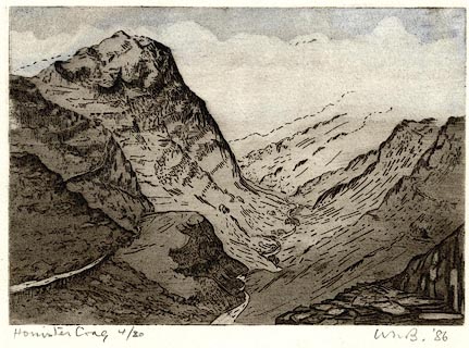 click to enlarge click to enlargePR0515.jpg printed at bottom left, right:- "Honister Crag 4/20 / WMB. '86" item:- Dove Cottage : 2008.107.464 Image © Wordsworth Trust, Grasmere |
|
|
|
||
| evidence:- | old postcard:- placename:- Honister Crag |
|
| source data:- | Postcard, colour photogravure, Honister Pass and Crag, the New Road, by G P Abrahams,
Keswick, Cumberland, purchased about 1954.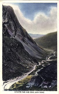 click to enlarge click to enlargePH0059.jpg item:- JandMN : 341 Image © see bottom of page |
|
|
|
||
| evidence:- | old print:- |
|
| source data:- | Print, colour halftone, Honister Pass, Dawn, painted by E W Haslehust, published early
20th century.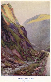 click to enlarge click to enlargePR0404.jpg painted at lower left:- "E. W. HASLEHUST." printed at bottom centre:- "HONISTER PASS - DAWN / (See page 45)" item:- Dove Cottage : 2008.107.397 Image © see bottom of page |
|
|
|
||
| evidence:- | old print:- placename:- Honister Crag |
|
| source data:- | Print, uncoloured engraving, Honister Crag and Pass, Cumberland, drawn by W H J Bool,
engraved by Whymper, published 1920s-30s?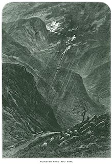 click to enlarge click to enlargePR0351.jpg On page 232 of Picturesque Europe, The Lake Country. Thunder and lightning, and a shepherd sitting out the storm. printed at lower left, right:- "WHJBool / WHYMPER Sc" printed at bottom:- "HONISTER CRAG AND PASS." item:- Dove Cottage : 2008.107.351 Image © see bottom of page |
|
|
|
||
| evidence:- | old print:- placename:- Honister Crag |
|
| source data:- | Print, uncoloured engraving, Crummock Water, Buttermere, and Honister Crag, Cumberland,
published 1900s?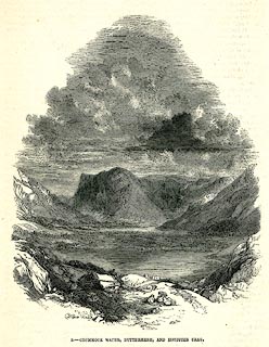 click to enlarge click to enlargePR0271.jpg printed at bottom:- "5.- CRUMMOCK WATER, BUTTERMERE, AND HONISTER CRAG." item:- Dove Cottage : 2008.107.271 Image © see bottom of page |
|
|
|
||
| evidence:- | old print:- placename:- Honister Crag |
|
| source data:- | Print, chromolithograph, Honister Crag, Cumberland, published by T Nelson and Sons,
London, 1900s?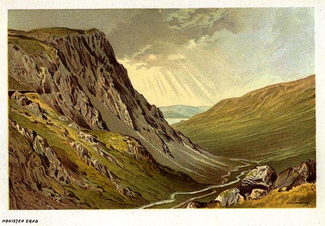 click to enlarge click to enlargePR0169.jpg From a set of prints, The Scenery of the English Lakes printed at lower right:- "T. NELSON &SONS" printed at bottom left:- "HONISTER CRAG" item:- Dove Cottage : 2008.107.169 Image © see bottom of page |
|
|
|
||
| evidence:- | old print:- Bogg 1898 |
|
| source data:- | Print, engraving, Honister Pass, Buttermere, Cumberland, by Owen Bowen, published
by Edmund Bogg, 3 Woodhouse Lane, and James Miles, Guildford Street, Leeds, Yorkshire,
1898.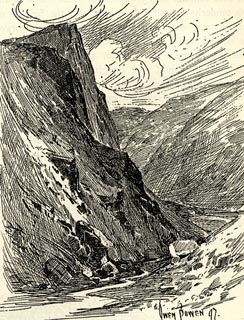 click to enlarge click to enlargeBGG177.jpg Included on p.199 of Lakeland and Ribblesdale, by Edmund Bogg. item:- JandMN : 231.77 Image © see bottom of page |
|
|
|
||
| evidence:- | outline view:- Jenkinson 1875 placename:- Honister Crag |
|
| source data:- | Print, lithograph, outline view, Panoramic Sketches from Helvellyn, Westmorland, by
Edwin A Pettitt, London, published by Edward Stanford, 55 Charing Cross, London, 1875. click to enlarge click to enlargeJk01E1.jpg "... Honister Crag ..." item:- JandMN : 28.5 Image © see bottom of page |
|
|
|
||
| evidence:- | old print:- Prior 1865 placename:- Honister Crag |
|
| source data:- | Print, uncoloured engraving, Buttermere, Honister Crag, Scarth Gap, and Haystacks,
Cumberland, published by John Garnett, Windermere, Westmorland, and by Simpkin, Marshall
and Co, London, 1865.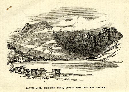 click to enlarge click to enlargePI0103.jpg Included on page 16 of the guide book, Ascents and Passes in the Lake District of England, by Herman Prior. printed at bottom:- "BUTTER-MERE, HONISTER CRAG, SCARTH GAP, AND HAYSTACKS." item:- JandMN : 235.5 Image © see bottom of page |
|
|
|
||
| evidence:- | old print:- placename:- Honister Crag |
|
| source data:- | Print, uncoloured engraving, Crummock Water, Buttermere, and Honister Crag, Cumberland,
by E Dalziel, published late 19th century?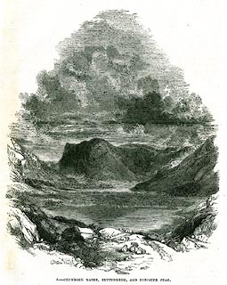 click to enlarge click to enlargePR0338.jpg On a page of The Land We Live In. printed at lower left:- "E. DALZIEL." printed at bottom:- "5.- CRUMMOCK WATER, BUTTERMERE, AND HONISTER CRAG." item:- Dove Cottage : 2008.107.338 Image © see bottom of page |
|
|
|
||
| evidence:- | old print:- Pyne 1853 |
|
| source data:- | Drawn by James Barker Pyne, 1848-1853, lithographed by T Picken, 1859.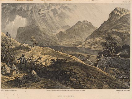 click to enlarge click to enlargePY17.jpg "Buttermere" item:- JandMN : 97.16 Image © see bottom of page |
|
|
|
||
| evidence:- | old print:- placename:- Honister Crag |
|
| source data:- | Print, uncoloured engraving, Honister Crag, Buttermere, Cumberland, by ?B Foster,
engraved by E Evans, 1850s-60s?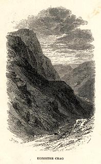 click to enlarge click to enlargePR0485.jpg printed at bottom left, right, centre:- "[B] Foster / E. EVANS SC. / HONISTER CRAG" item:- Dove Cottage : 2008.107.434 Image © see bottom of page |
|
|
|
||
| evidence:- | outline view:- Black 1856 placename:- Honister Crag |
|
| source data:- | Print, lithograph, Outline Views, Buttermere - Mountains as seen from the Knots near
the Hotel at Buttermere, and Mountains as seen at the Seat in Lanthwaite Wood, Scale
Hill, by J Flintoft, Keswick, Cumberland, engraved by R Mason, Edinburgh, Lothian,
about 1900. click to enlarge click to enlargeBC08E5.jpg "... 2 Honister Crag ... 2 Honister Crag ..." item:- JandMN : 37.19 Image © see bottom of page |
|
|
|
||
| evidence:- | outline view:- Black 1841 (3rd edn 1846) placename:- Honister Crag |
|
| source data:- | Print, engraving, outline view, Mountains as seen from The Knots near the Victoria
at Buttermere, and Mountains as seen at the Seat in Lanthwaite Wood, Scale Hill, by
J Flintoft, Keswick, Cumberland, engraved by R Mason, Edinburgh, Lothian, about 1846.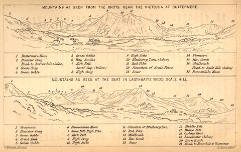 click to enlarge click to enlargeBC02E7.jpg "... 2 Honister Crag ... 2 Honister Crag ..." item:- JandMN : 32.11 Image © see bottom of page |
|
|
|
||
| evidence:- | outline view:- Tattersall 1836 placename:- Honister Crag |
|
| source data:- | Print, engraving, Honister Crag, Buttermere, Cumberland, drawn by George Tattersall,
engraved by W F Topham, published by Sherwood and Co, Paternoster Row, London, about
1836.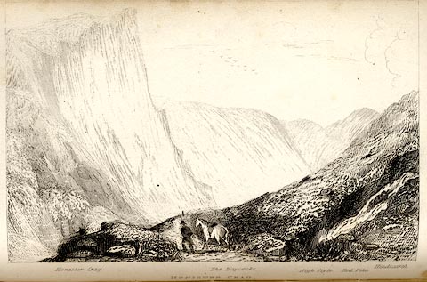 click to enlarge click to enlargeTAT126.jpg The print is captioned with mountain names and acts as an outline view. Tipped in opposite p.73 of The Lakes of England, by George Tattersall. printed at bottom:- "HONISTER CRAG." printed at bottom left to right:- "Honister Crag. / The Haycocks. / High Style. / Red Pike. / Hindscarth." item:- Armitt Library : A1204.27 Image © see bottom of page |
|
|
|
||
| evidence:- | old print:- Rose 1832-35 |
|
| source data:- | Print, engraving, Honister Crag, Cumberland, by Thomas Allom, engraved by W Floyd,
1833.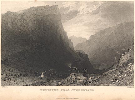 click to enlarge click to enlargeR214.jpg "Honister Crag, Cumberland" Historical scene of the battle of local farmers against the younger Groeme, scottish border raiders. item:- JandMN : 96.9 Image © see bottom of page |
|
|
|
||
| evidence:- | old print:- Farington 1816 (plate 27) placename:- Honister Crag |
|
| source data:- | Print, uncoloured engraving, Honister Crag, drawn by Joseph Farington, engraved by
Samuel Middiman, published by T Cadell and W Davies, Strand, London, 1815.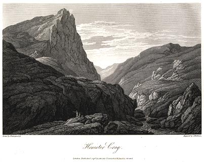 click to enlarge click to enlargePR0430.jpg Plate 27 in The Lakes of Lancashire, Westmorland, and Cumberland. printed at bottom, left, right, centre:- "Drawn by J. Farington R.A. / Engraved by S. Middiman. / Honister Crag. / London Published Septr. 15, 1815, by T. Cadell &W. Davies, Strand." item:- JandMN : 171 Image © see bottom of page |
|
|
|
||
| evidence:- | old print:- Gresham Publishing 1900s placename:- Honister Crag |
|
| source data:- | Print, colour halftone, Head of Buttermere and Honister Crag, Cumberland, by Ernest
W Haslehurst, published by The Gresham Publishing Co, 66 Chandos Street, London, 1900s? click to enlarge click to enlargePR1569.jpg Tipped in opposite p.48 of The English Lakes section of a volume of Our Beautiful Homeland. printed at bottom:- "HEAD OF BUTTERMERE AND HONISTER CRAG" item:- JandMN : 381.11 Image © see bottom of page |
|
|
|
||
Lakes Guides menu.