 Old Cumbria Gazetteer
 |
 |
|
| Kirk Fell, Nether Wasdale | ||
| Kirk Fell | ||
| civil parish:- | Nether Wasdale (formerly Cumberland) | |
| civil parish:- | Ennerdale and Kinniside (formerly Cumberland) | |
| county:- | Cumbria | |
| locality type:- | hill | |
| locality type:- | fell | |
| coordinates:- | NY19491049 | |
| 1Km square:- | NY1910 | |
| 10Km square:- | NY11 | |
| altitude:- | 2631 feet | |
| altitude:- | 802m | |
|
|
||
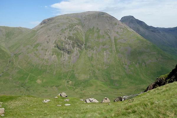 BYO68.jpg (taken 18.6.2013) 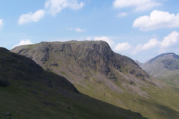 BUX39.jpg (taken 4.7.2011) |
||
|
|
||
| evidence:- | old map:- OS County Series (Cmd 74 7) placename:- Kirk Fell |
|
| source data:- | Maps, County Series maps of Great Britain, scales 6 and 25
inches to 1 mile, published by the Ordnance Survey, Southampton,
Hampshire, from about 1863 to 1948. |
|
|
|
||
| evidence:- | old print:- Farington 1816 placename:- Kirk Fell |
|
| source data:- | Print, uncoloured engraving and descriptive text, Wastdale Village, Nether Wasdale,
Cumberland, drawn by Joseph Farington, engraved by J Landseer, published by T Cadell
and W Davies, Strand, London, 1815.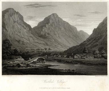 click to enlarge click to enlargeFA0418.jpg printed, bottom left, right, centre "Drawn by J. Farington R.A. / Engraved by J. Landseer A.R.A. / Wastdale Village. / London Published Septr. 15, 1815, by T. Cadell &W. Davies, Strand." item:- Armitt Library : A6666.18 Image © see bottom of page |
|
|
|
||
| evidence:- | old map:- Otley 1818 placename:- Kirk Fell |
|
| source data:- | Map, uncoloured engraving, The District of the Lakes,
Cumberland, Westmorland, and Lancashire, scale about 4 miles to
1 inch, by Jonathan Otley, 1818, engraved by J and G Menzies,
Edinburgh, Scotland, published by Jonathan Otley, Keswick,
Cumberland, et al, 1833.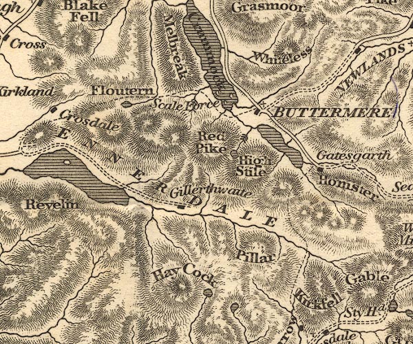 OT02NY11.jpg item:- JandMN : 48.1 Image © see bottom of page |
|
|
|
||
| evidence:- | outline view:- Otley 1823 (4th edn 1830) placename:- Kirkfell |
|
| source data:- | Print, engraving, outline view, Some of the Western Mountains as seen from Helvellyn,
published by Jonathan Otley, Keswick, Cumberland et al, 1830.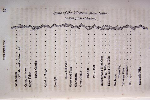 click to enlarge click to enlargeO75E02.jpg p.57 in A Concise Description of the English Lakes, by Jonathan Otley, 4th edition, 1830. "Some of the Western Mountains: / as seen from Helvellyn." "Wetherlam / Old Man - Coniston Fell / Carrs, or Scars / Gray Friar / Black Combe / Crinkle Crags / Bowfell / Scawfell Pike / Great-end Crag / Glaramara / Great Gable / Kirkfell / Pillar Fell / Honister and High Crag / High Stile / Dalehead and Red Pike / Robinson / Blake Fell / Witeless Pike / Grasmoor / Ill Crags / Grisedale Pike" item:- Armitt Library : A1175.3 Image © see bottom of page |
|
|
|
||
| evidence:- | outline view:- Otley 1823 (4th edn 1830) placename:- Kirkfell |
|
| source data:- | Print, engraving, outline view, The Mountains of Crummock and Buttermere as seen on
the Road between Scale-Hill and Loweswater, published by Jonathan Otley, Keswick,
Cumberland et al, 1830.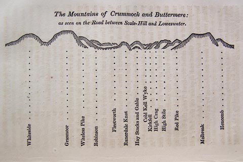 click to enlarge click to enlargeO75E07.jpg p.125 in A Concise Description of the English Lakes, by Jonathan Otley, 4th edition, 1830. "The Mountains of Crummock and Buttermere: / as seen on the Road between Scale-Hill and Loweswater." "Whiteside / Grasmoor / Witeless Pike / Robinson / Fleetworth / Rannerdale Knot / Hay Stacks and Gable / Cold Kell Wyke / Kirkfell / High Crag / High Stile / Red Pike / Melbreak / Hencomb" item:- Armitt Library : A1175.7 Image © see bottom of page |
|
|
|
||
| evidence:- | outline view:- Otley 1823 (8th edn 1849) placename:- Kirkfell |
|
| source data:- | Engraving, outline view of mountains, A Group of Mountains seen from Helvellyn, looking
towards the South West, drawn by T Binns, engraved by O Jewitt, opposite p.50 of A
Descriptive Guide of the English Lakes, by Jonathan Otley, 8th edition, 1849.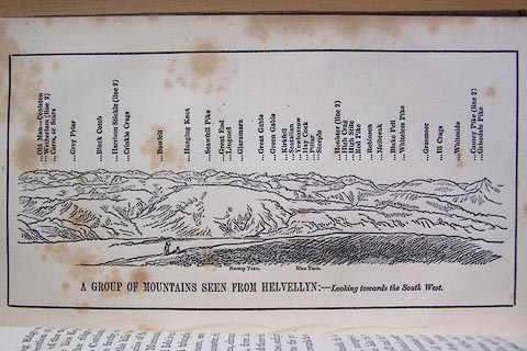 click to enlarge click to enlargeO80E17.jpg item:- Armitt Library : A1180.18 Image © see bottom of page |
|
|
|
||
| evidence:- | probably outline view:- Otley 1823 (5th edn 1834) placename:- Kirkfell |
|
| source data:- | Print, woodcut outline view, A Group of Mountains, seen from
Helvellyn, by Jonathan Otley, Keswick, Cumberland, 1830.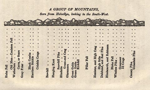 click to enlarge click to enlargeOT2E09.jpg Printed on p.63 of A Concise Description of the English Lakes, by Jonathan Otley, 5th edition, 1834. "A GROUP OF MOUNTAINS, Seen from Helvellyn, looking to the South-West." "Holm Fell / Old Man - Coniston Fell / Wetherlam / Carrs, or Scars / Gray Friar / Black Combe / Harrison Stickle / Crinkle Crags / Bowfell / Hanging Knot / Scawfell Pike / Hindside / Great-end Crag / Glaramara / Great Gable / Green Gable / Kirkfell / Pillar Fell / Honister, and High Crag / High Stile / Dalehead, and Red Pike / Hindscarth, and Robinson / Blake Fell / Witeless Pike / Grasmoor / Ill Crags / Causey Pike / Grisedale Pike" item:- JandMN : 48.10 Image © see bottom of page |
|
|
|
||
| evidence:- | old map:- Garnett 1850s-60s H placename:- Kirkfell |
|
| source data:- | Map of the English Lakes, in Cumberland, Westmorland and
Lancashire, scale about 3.5 miles to 1 inch, published by John
Garnett, Windermere, Westmorland, 1850s-60s.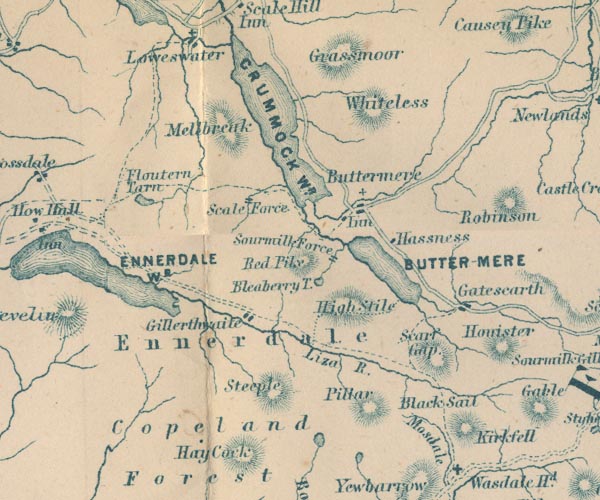 GAR2NY11.jpg "Kirkfell" hill hachuring item:- JandMN : 82.1 Image © see bottom of page |
|
|
|
||
| evidence:- | outline view:- Martineau 1855 placename:- Kirkfell |
|
| source data:- | Print, engraving, outline view, Mountains seen from Lanthwaite Wood Crummock Water,
drawn by L Aspland, engraved by W Banks, Edinburgh, published by John Garnett, Windermere,
Westmorland, and by Whittaker and Co, London, 1855.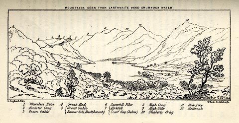 click to enlarge click to enlargeMNU113.jpg Opposite p.84 in A Complete Guide to the English Lakes, by Harriet Martineau. The view is captioned, numbers referring to mountains in the image:- "1 Whiteless Pike, 2 Honister Crag, 3 Green Gable, 4 Great End, 5 Great Gable / Rannerdale Knott (beneath), 6 Scawfell Pike, 7 Kirkfell / Scarf Gap (below), 8 High Crag, 9 High Stile, 10 Bleaberry Crag, 11 Red Pike, 12 Melbreak." "MOUNTAINS SEEN FROM LANTHWAITE WOOD CRUMMOCK WATER." "L Aspland Delt. / W Banks Sc Edinr." item:- Armitt Library : A1159.13 Image © see bottom of page |
|
|
|
||
| evidence:- | old text:- Martineau 1855 placename:- Kirkfell item:- compass |
|
| source data:- | Guide book, A Complete Guide to the English Lakes, by Harriet
Martineau, published by John Garnett, Windermere, Westmorland,
and by Whittaker and Co, London, 1855; published 1855-76. goto source goto sourcePage 121:- "..." "Kirkfell, which stands backward, between Yewbarrow and Great Gable, was very tempting to a tourist who explored this neighbourhood some years ago; and he set out to get to Buttermere by Blacksail and Scarf Gap. After hours of walking, he struck into the deep ravine between Kirkfell and Great Gable; and when he arrived within sight of a lake at night, he was confounded to find it still Wast Water. He had walked completely round the mountain, instead of getting on. We observed to a comrade that this could not have happened if the tourist had carried a pocket-compass. "And not having a compass," said our friend, "he fetched one."" |
|
|
|
||
| evidence:- | old photograph:- Bell 1880s-1940s |
|
| source data:- | Photograph, black and white, Wasdale Head, Kirk Fell behind, Nether Wasdale, Cumberland,
by Herbert Bell, photographer, Ambleside, Westmorland, 1890s.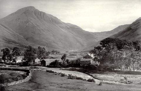 click to enlarge click to enlargeHB0905.jpg item:- Armitt Library : ALPS580 Image © see bottom of page |
|
|
|
||
| evidence:- | outline view:- Seascale 1920s-30s placename:- Kirk Fell |
|
| source data:- | Print, uncoloured engraving, outline view, mountains from Seascale, published by Edward
Burrow and Son, Cheltenham, Gloucestershire, 1920s-30s.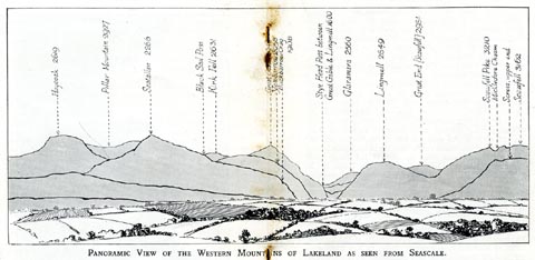 click to enlarge click to enlargeSES113.jpg "PANORAMIC VIEW OF THE WESTERN MOUNTAINS OF LAKELAND AS SEEN FROM SEASCALE." "... Kirk Fell 2631 ..." item:- JandMN : 1079.13 Image © see bottom of page |
|
|
|
||
| evidence:- | outline view:- Jenkinson 1875 placename:- Kirk Fell |
|
| source data:- | Print, lithograph, outline view, Panoramic Sketches from Helvellyn, Westmorland, by
Edwin A Pettitt, London, published by Edward Stanford, 55 Charing Cross, London, 1875. click to enlarge click to enlargeJk01E1.jpg "... Kirk fell ..." item:- JandMN : 28.5 Image © see bottom of page |
|
|
|
||
| evidence:- | outline view:- Jenkinson 1875 placename:- Kirk Fell |
|
| source data:- | Print, lithograph, outline view, Panoramic Sketches from Skiddaw, Cumberland, by Edwin
A Pettitt, London, published by Edward Stanford, 55 Charing Cross, London, 1875. click to enlarge click to enlargeJk01E2.jpg "... Kirk Fell ..." item:- JandMN : 28.8 Image © see bottom of page |
|
|
|
||
| evidence:- | outline view:- Jenkinson 1875 placename:- Kirk Fell |
|
| source data:- | Print, lithograph, outline view, Panoramic Sketches from Scawfell Pike, Cumberland,
by Edwin A Pettitt, London, published by Edward Stanford, 55 Charing Cross, London,
1875. click to enlarge click to enlargeJk01E3.jpg "... Kirk Fell ..." item:- JandMN : 28.9 Image © see bottom of page |
|
|
|
||
| evidence:- | outline view:- Matthew 1866 placename:- Kirkfell |
|
| source data:- | Print, engraving, outline view, Ennerdale, Cumberland, published by J Richardson,
Highgate, Kendal, Westmorland, 1866.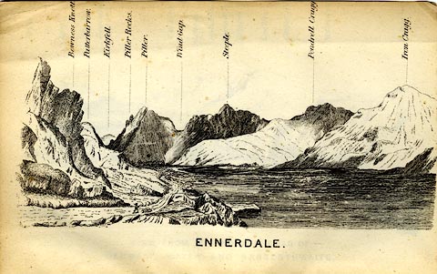 click to enlarge click to enlargeMW1E04.jpg Tipped in before p.1 of The English Lakes, Peaks and Passes, from Kendal to Keswick, by George King Matthew. printed at bottom:- "ENNERDALE" printed at caption to mountains:- "... Kirkfell. ..." item:- Armitt Library : A1168.4 Image © see bottom of page |
|
|
|
||
| evidence:- | outline view:- Matthew 1866 placename:- Kirkfell |
|
| source data:- | Print, engraving, outline view, Mountains as seen from the Road to Wastwater near
Murthwaiteside, Cumberland, published by J Richardson, Highgate, Kendal, Westmorland,
1866.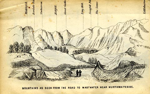 click to enlarge click to enlargeMW1E03.jpg Tipped in before p.1 of The English Lakes, Peaks and Passes, from Kendal to Keswick, by George King Matthew. printed at bottom:- "MOUNTAINS AS SEEN FROM THE ROAD TO WASTWATER NEAR MURTHWAITESIDE." printed at caption to mountains:- "... Kirkfell. ..." item:- Armitt Library : A1168.3 Image © see bottom of page |
|
|
|
||
| evidence:- | outline view:- Black 1856 placename:- Kirk Fell |
|
| source data:- | Print, lithograph, Outline Views, Buttermere - Mountains as seen from the Knots near
the Hotel at Buttermere, and Mountains as seen at the Seat in Lanthwaite Wood, Scale
Hill, by J Flintoft, Keswick, Cumberland, engraved by R Mason, Edinburgh, Lothian,
about 1900. click to enlarge click to enlargeBC08E5.jpg "... 7 Kirk Fell ... 8 Kirk Fell ..." item:- JandMN : 37.19 Image © see bottom of page |
|
|
|
||
| evidence:- | outline view:- Linton 1852 placename:- Kirk Fell |
|
| source data:- | Print, engraving, outline views, Mountains as Seen from the Esk Viaduct, the Eskmeals
Viaduct, and Mountains as Seen from the Viaduct near Drigg, the Irt Viaduct, Whitehaven
and Furness Junction Railway, Cumberland, engraved by W H Lizars, Edinburgh, published
by Whittaker and Co, London, and by R Gibson and Son and by Callander and Dixon, Whitehaven,
Cumberland, 1852.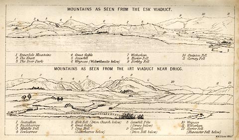 click to enlarge click to enlargeLN1E13.jpg Tipped in opposite p.86 of A Handbook of the Whitehaven and Furness Railway, by John Linton. item:- Armitt Library : A1158.11 Image © see bottom of page |
|
|
|
||
| evidence:- | outline view:- Black 1841 (3rd edn 1846) placename:- Kirk Fell |
|
| source data:- | Print, engraving, outline view, Mountains as seen from The Knots near the Victoria
at Buttermere, and Mountains as seen at the Seat in Lanthwaite Wood, Scale Hill, by
J Flintoft, Keswick, Cumberland, engraved by R Mason, Edinburgh, Lothian, about 1846.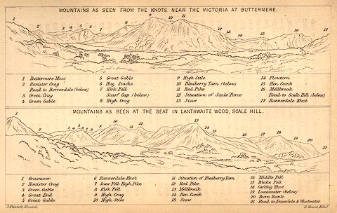 click to enlarge click to enlargeBC02E7.jpg "... 7 Kirk Fell ... 8 Kirk Fell ..." item:- JandMN : 32.11 Image © see bottom of page |
|
|
|
||
| evidence:- | old print:- Farington 1816 (plate 25) |
|
| source data:- | Print, uncoloured engraving, Wastdale Village, drawn by Joseph Farington, engraved
by J Landseer, published by T Cadell and W Davies, Strand, London, 1815.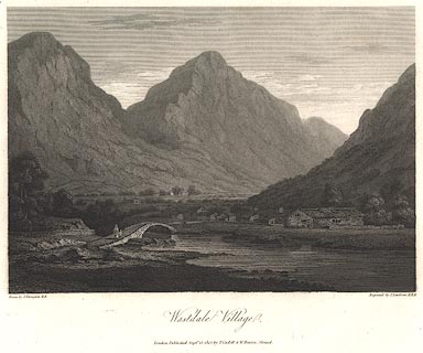 click to enlarge click to enlargeBNV37.jpg Plate 25 in The Lakes of Lancashire, Westmorland and Cumberland ... with text by Thomas Hartwell Horne. item:- private collection : 76 Image © see bottom of page |
|
|
|
||
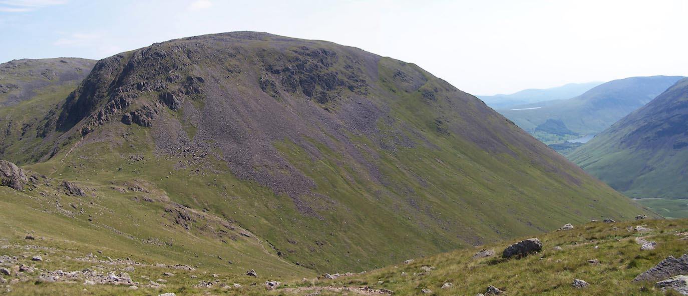 Click to enlarge BUX41.jpg (taken 4.7.2011) 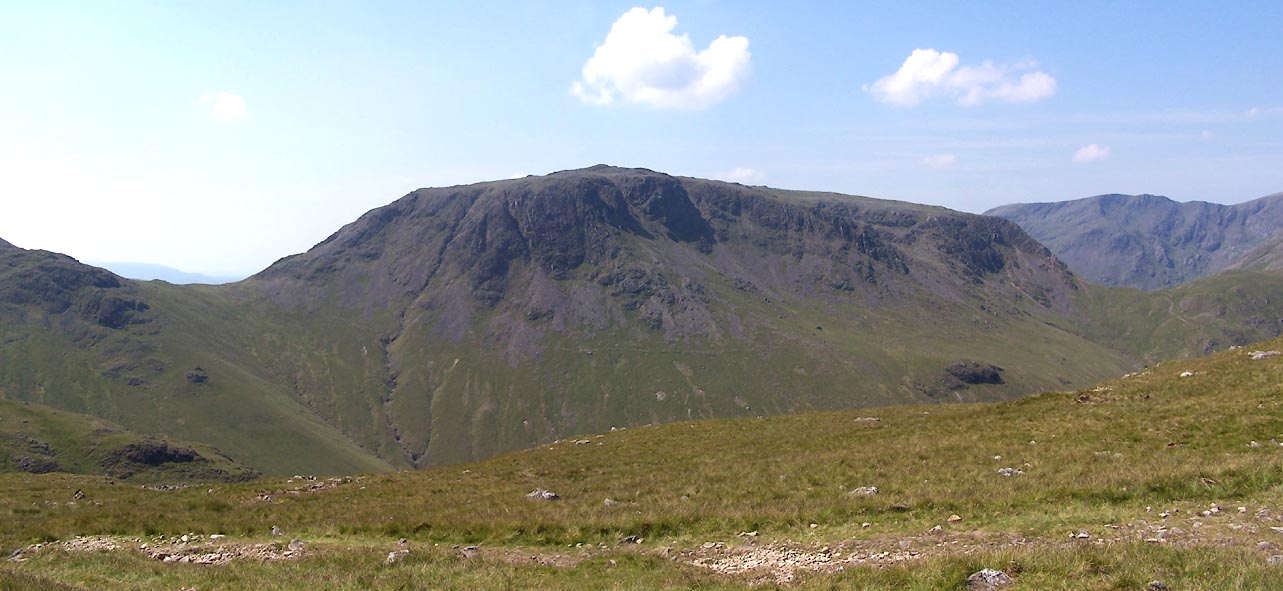 Click to enlarge BUX40.jpg (taken 4.7.2011)  BNM84.jpg (taken 4.4.2007) 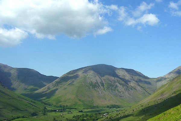 BNV07.jpg (taken 9.6.2007) 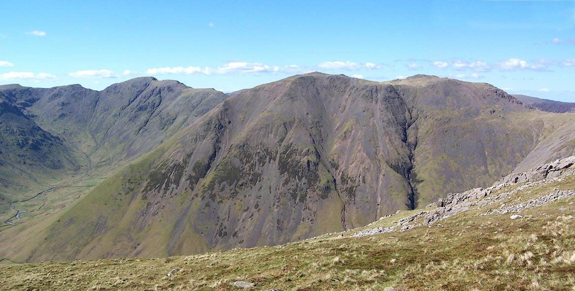 Click to enlarge BQO26.jpg (taken 12.5.2009) 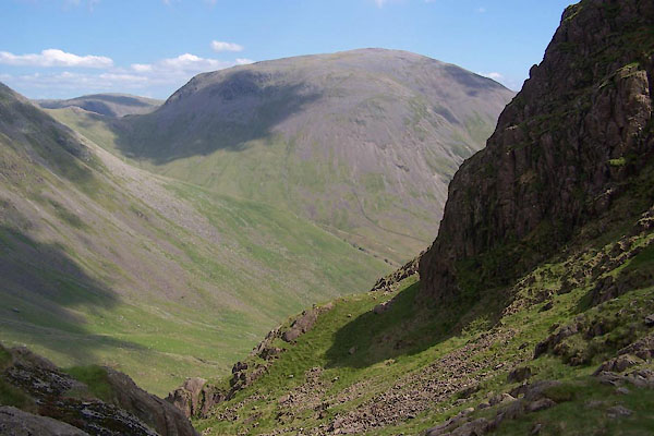 BUR19.jpg From the head of Mosedale. (taken 3.6.2011) 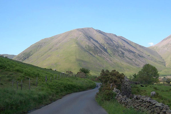 BUR30.jpg (taken 3.6.2011) 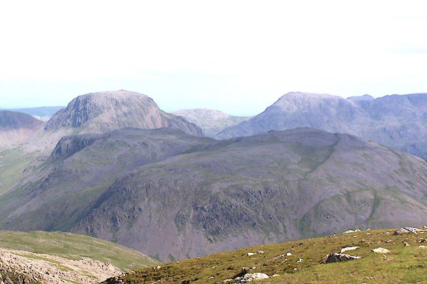 BQX37.jpg Great Gable and Kirk Fell, from Pillar. (taken 25.6.2009) 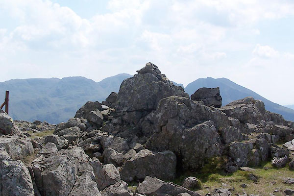 BUX35.jpg A cairn, (taken 4.7.2011) 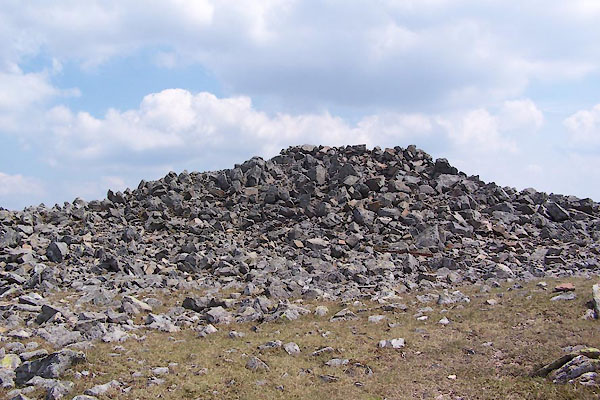 BUX38.jpg Summit cairn, (taken 4.7.2011) |
||
|
|
||
Lakes Guides menu.