 Old Cumbria Gazetteer
 |
 |
|
||||||||||||
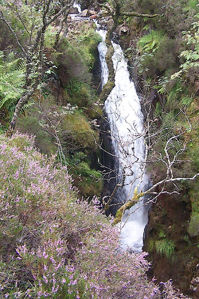
| Scale Force, Loweswater | ||||||||||||||
| Scale Force | ||||||||||||||
| site name:- | Scale Beck | |||||||||||||
| civil parish:- | Loweswater (formerly Cumberland) | |||||||||||||
| county:- | Cumbria | |||||||||||||
| locality type:- | waterfall | |||||||||||||
| coordinates:- | NY150170 | |||||||||||||
| 1Km square:- | NY1517 | |||||||||||||
| 10Km square:- | NY11 | |||||||||||||
|
|
||||||||||||||
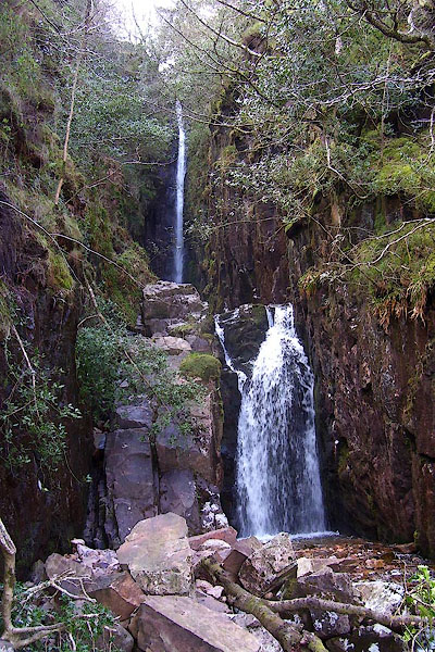 BPA49.jpg (taken 16.4.2008) |
||||||||||||||
|
|
||||||||||||||
| evidence:- | old map:- OS County Series (Cmd 69 5) placename:- Scale Force |
|||||||||||||
| source data:- | Maps, County Series maps of Great Britain, scales 6 and 25
inches to 1 mile, published by the Ordnance Survey, Southampton,
Hampshire, from about 1863 to 1948. |
|||||||||||||
|
|
||||||||||||||
| evidence:- | probably descriptive text:- West 1778 (11th edn 1821) |
|||||||||||||
| source data:- | Guide book, A Guide to the Lakes, by Thomas West, published by
William Pennington, Kendal, Cumbria once Westmorland, and in
London, 1778 to 1821. goto source goto sourcePage 138:- "..." "... Just in front [from Rannerdale Knotts], between Blea-crag and Mell-break, (two spiral hills) the hoarse resounding noise of a water-fall is heard across the lake, concealed within the bosom of the cliff, through which it has forced its way, and when viewed from the foot of the fall, is a most astonishing phaenomenon." |
|||||||||||||
|
|
||||||||||||||
| evidence:- | old map:- Crosthwaite 1783-94 (But/Cru/Low) placename:- Scale Force |
|||||||||||||
| source data:- | Map, uncoloured engraving, An Accurate Map of Buttermere,
Crummock and Loweswater Lakes, scale about 3 inches to 1 mile,
by Peter Crosthwaite, Keswick, Cumberland, 1794, version
published 1800.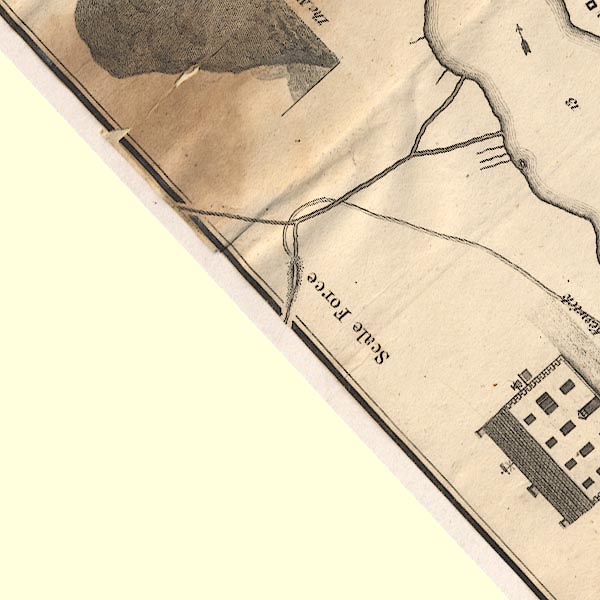 CT8NY11N.jpg "Scale Force" Elsewhere on the map:- "The water at Scale Force falls 152 feet within 6 Degrees of perpendicular, and the mean quantity of water to be meet with would perhaps pass thorough a hole at the lower end of a Hogshead one foot Square, before it would overflow the upper end." item:- Armitt Library : 1959.191.2 Image © see bottom of page |
|||||||||||||
|
|
||||||||||||||
| evidence:- | old text:- Gents Mag |
|||||||||||||
| source data:- | Magazine, The Gentleman's Magazine or Monthly Intelligencer or
Historical Chronicle, published by Edward Cave under the
pseudonym Sylvanus Urban, and by other publishers, London,
monthly from 1731 to 1922. goto source Gentleman's Magazine 1792 p.1114 "..." ""Scale-Force Waterfall is two hundred feet perpendicular, except where it flushes over a small jut. The steep on both sides is covered with variety of moss, fern, ash, and oak, all fed by the constant spray; and flourish in indescribable verdure. The delicacy of the effect is heightened by being in a narrow chasm, a hundred yards in the rock, before it rushes into the lower fall, at the point of which you have the grand view. Clamber up the left side, and look into the first basin; and, although you may be wet with the spray, you cannot help feeling the solemnity of the deep, this musical abyss, enchanting as verdure and melody can make it: and although there has been no rain for nine days, it far exceeds any thing of the kind I ever saw, and the boasted one at Coo in Germany sinks below comparison. I suppose we saw it in the best state it could be received in. Had it been after rain, it might have filled us with astonishment; but what would have becomre of the verdure of the sides? The foam would have nearly covered them. As we saw it, every part was in unison with the musick it created; the mind comprehended it, and carried away one of the most inimitable scenes that ever enriched the fancy of man, or graced the pencil of a Moore." |
|||||||||||||
|
|
||||||||||||||
| evidence:- | old text:- Green 1810 placename:- Scale Force |
|||||||||||||
| source data:- | Set of prints, soft ground etchings, Sixty Studies from Nature,
by William Green, Ambleside, Westmorland, drawn 1808-10,
published 1810. goto source page 69:- "... Scale Force is a considerable water-fall, in a cleft of" goto sourcepage 70:- "the hill between Melbreak and Red Pike, it is about half a mile from the head of Crummock Water; and those who take the Scale Hill boat, or go round the lake, will enjoy a fine view of the two lakes of Crummock and Buttermere ..." |
|||||||||||||
|
|
||||||||||||||
| evidence:- | old map:- Otley 1818 placename:- Scale Force |
|||||||||||||
| source data:- | Map, uncoloured engraving, The District of the Lakes,
Cumberland, Westmorland, and Lancashire, scale about 4 miles to
1 inch, by Jonathan Otley, 1818, engraved by J and G Menzies,
Edinburgh, Scotland, published by Jonathan Otley, Keswick,
Cumberland, et al, 1833.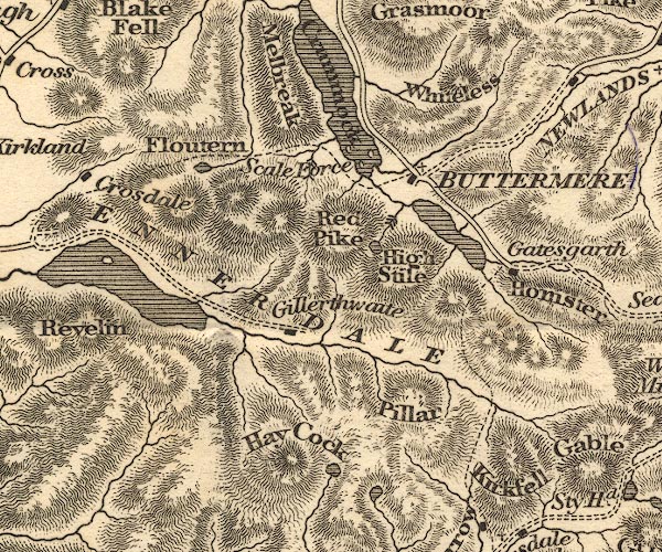 OT02NY11.jpg item:- JandMN : 48.1 Image © see bottom of page |
|||||||||||||
|
|
||||||||||||||
| evidence:- | old print:- Fielding and Walton 1821 (plate 34) placename:- Scale Force |
|||||||||||||
| source data:- | Print, coloured aquatint, Scale Force, Loweswater, Cumberland, drawn by Theodore H
A Fielding, published by R Ackermann, 101 Strand, London, 1821.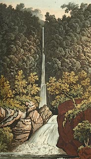 click to enlarge click to enlargeFW0134.jpg Tipped in opposite p.222 in A Picturesque Tour of the English Lakes. item:- Dove Cottage : 1993.R566.34 Image © see bottom of page |
|||||||||||||
|
|
||||||||||||||
| evidence:- | descriptive text:- Otley 1823 (5th edn 1834) item:- geology |
|||||||||||||
| source data:- | Guide book, A Concise Description of the English Lakes, the
mountains in their vicinity, and the roads by which they may be
visited, with remarks on the mineralogy and geology of the
district, by Jonathan Otley, published by the author, Keswick,
Cumberland now Cumbria, by J Richardson, London, and by Arthur
Foster, Kirkby Lonsdale, Cumbria, 1823; published 1823-49,
latterly as the Descriptive Guide to the English Lakes. goto source Page 23:- "... There is a comfortable inn at Buttermere, between the two lakes, and another at Scale Hill on the foot of Crummock; at one of which places a boat is usually taken, as well for a survey of the scenery, as being the most convenient way of seeing the noted waterfall of Scale Force, on the opposite side of the lake." goto sourcePage 43:- "SCALE FORCE, near Buttermere, is the deepest in all the region of the lakes: it is said to fall at once one hundred and fifty-two feet, besides a smaller fall below. The water is precipitated into a tremendous chasm, between two mural rocks of sienite, beautifully overhung with trees which have fixed their roots in the crevices; the sides clad with a profusion of plants which glitter with the spray of the fall. Visiters (sic) generally enter from below, into this chasm, where the air, filled with moisture and shaded from the sun, feels cool and damp as in a cellar. Passing the lower, they may proceed towards the foot of the principal fall; till the more copious sprinkling of the spray compels them to retrace their steps." "..." goto sourcePage 127:- "At Buttermere, a boat is usually taken upon Crummock Lake, as well as for the views of the scenery as being the most convenient way of seeing Scale Force. It is an agreeable walk of half a mile to the water, and after a pleasant little voyage of nearly a mile, a walk of three quarters of a mile reaches to the fall. Travellers may indeed walk from the inn to Scale Force; but the path being wet and unpleasant, a boat is greatly to be preferred. ..." goto source"At Scale Hill, a boat may be taken on Crummock Lake, from whence the mountains surrounding that and Buttermere, may be seen to great advantage. The party may be landed for a view of Scale Force, ..." "..." goto sourcePage 149:- "A variety of granite with reddish felspar, and which from a deficiency of mica, has sometimes been" goto sourcePage 151:- "called sienite, .... it becomes a finer grained sienite, in which form it extends through the mountains ... as far as Scale Force, and to the side of Buttermere Lake. It contains veins of red hematite and micaceous iron ore." |
|||||||||||||
|
|
||||||||||||||
| evidence:- | descriptive text:- Ford 1839 (3rd edn 1843) placename:- Scale Force item:- height, Scale Force; boat |
|||||||||||||
| source data:- | Guide book, A Description of Scenery in the Lake District, by
Rev William Ford, published by Charles Thurnam, Carlisle, by W
Edwards, 12 Ave Maria Lane, Charles Tilt, Fleet Street, William
Smith, 113 Fleet Street, London, by Currie and Bowman,
Newcastle, by Bancks and Co, Manchester, by Oliver and Boyd,
Edinburgh, and by Sinclair, Dumfries, 1839. goto source Page 89:- "..." "Scale Force is often visited from Buttermere. From the inn there is a foot-path, but over very swampy ground; it is, therefore, better to take a" goto sourcePage 90:- "boat and row down Crummock Lake about a mile; on landing, a rugged path brings you to it." "'It springs at once, with sudden leap, Down from the immeasurable steep, From rock to rock, with shivering force rebounding, The mighty cataract rushes.'" "This is the deepest fall, the water being hurled downwards in one clear leap of one hundred and fifty-six feet, next, in another forty-four feet. The chasm into which the waters sink, is from twelve to twenty feet in width, and is between two walls of sienite, beautifully covered with trees, which have fixed their roots in the interstices, whilst the sides are clad with a profusion of plants. The coolness and dampness are very great, and will soon warn the tourist from this stupendous scene." goto sourcePage 169:- "..." "... On the west side of Crummock is Scale Force, situated in a deep chasm, and the water-falls, at a single leap, 156 feet. (See page 89.)" goto sourcePage 179:- "WATERFALLS."
|
|||||||||||||
|
|
||||||||||||||
| evidence:- | old map:- Ford 1839 map placename:- Scale Force |
|||||||||||||
| source data:- | Map, uncoloured engraving, Map of the Lake District of
Cumberland, Westmoreland and Lancashire, scale about 3.5 miles
to 1 inch, published by Charles Thurnam, Carlisle, and by R
Groombridge, 5 Paternoster Row, London, 3rd edn 1843.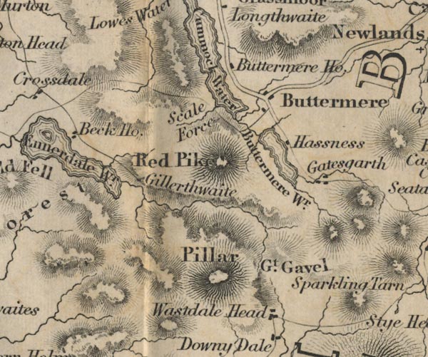 FD02NY11.jpg "Scale Force" item:- JandMN : 100.1 Image © see bottom of page |
|||||||||||||
|
|
||||||||||||||
| evidence:- | old map:- Garnett 1850s-60s H placename:- Scale Force |
|||||||||||||
| source data:- | Map of the English Lakes, in Cumberland, Westmorland and
Lancashire, scale about 3.5 miles to 1 inch, published by John
Garnett, Windermere, Westmorland, 1850s-60s.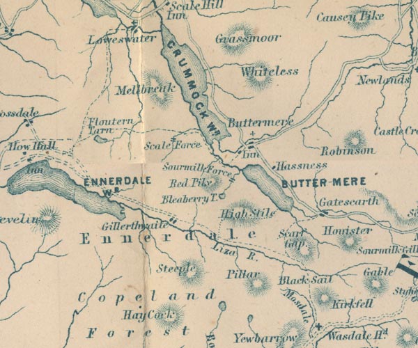 GAR2NY11.jpg "Scale Force" two lines across a stream, waterfall item:- JandMN : 82.1 Image © see bottom of page |
|||||||||||||
|
|
||||||||||||||
| evidence:- | old print:- Nelson 1853 (edn 1880s) placename:- Scale Force |
|||||||||||||
| source data:- | Print, uncoloured, Scale Force, Lower Fall, Loweswater, Cumberland, published by Thomas
Nelson and Sons, London, 1853 edn 1880s?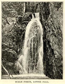 click to enlarge click to enlargeNS0306.jpg On p.20 of Views of the English Lakes, and Tourists Guide to the English Lakes. printed at bottom:- "SCALE FORCE, LOWER FALL." item:- JandMN : 474.7 Image © see bottom of page |
|||||||||||||
|
|
||||||||||||||
| evidence:- | old text:- Martineau 1855 item:- boat; horse |
|||||||||||||
| source data:- | Guide book, A Complete Guide to the English Lakes, by Harriet
Martineau, published by John Garnett, Windermere, Westmorland,
and by Whittaker and Co, London, 1855; published 1855-76. goto source Page 84:- "... he may leave the horse to bait at Buttermere while he takes a boat to see Scale Force, and returns." "The meadow between the two lakes is not more than a mile in extent. The walk to the boat lies through its small patches of pasture and wooded knolls; and a" goto sourcePage 85:- "pretty walk it is. The path is prolonged to Scale Force over the fields; but it is usually too swampy to be agreeable, when a boat can be had. A short row brings the stranger to the mouth of the stream from the force; and he has then to walk a mile among stones, and over grass, and past an old fold. The chasm between two walls of rock, which are feathered with bright waving shrubs, affords a fall of 160 feet,- high enough to convert the waters into spray before they reach the ground. It is one of the loftiest water-falls in the country; and some think it the most elegant. ..." |
|||||||||||||
|
|
||||||||||||||
| evidence:- | old text:- Martineau 1855 |
|||||||||||||
| source data:- | Guide book, A Complete Guide to the English Lakes, by Harriet
Martineau, published by John Garnett, Windermere, Westmorland,
and by Whittaker and Co, London, 1855; published 1855-76. goto source Page 180:- "WATERFALLS." "No. : Names and Situations of Falls. : Counties : Feet in Height." "5 : Scale Force, S.W. Side of Crummock Lake : Cumberland : 160" |
|||||||||||||
|
|
||||||||||||||
| evidence:- | old photograph:- Bell 1880s-1940s |
|||||||||||||
| source data:- | Photograph, sepia, Scale Force, Loweswater, Cumberland, by Herbert Bell, Ambleside,
Westmorland, 1890s.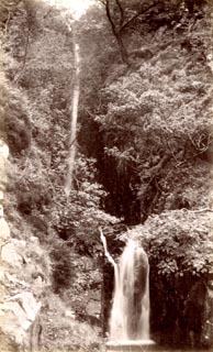 click to enlarge click to enlargeHB0471.jpg item:- Armitt Library : ALPS130 Image © see bottom of page |
|||||||||||||
|
|
||||||||||||||
| evidence:- | old print:- Gresham Publishing 1900s placename:- Scale Force |
|||||||||||||
| source data:- | Print, colour halftone, Scale Force, Crummock Water, Cumberland, by Ernest W Haslehurst,
published by The Gresham Publishing Co, 66 Chandos Street, London, 1900s?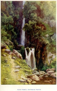 click to enlarge click to enlargePR1570.jpg Tipped in opposite p.52 of The English Lakes section of a volume of Our Beautiful Homeland. printed at bottom:- "SCALE FORCE, CRUMMOCK WATER" printed at lower left:- "E. W. HASLEHURST" item:- JandMN : 381.12 Image © see bottom of page |
|||||||||||||
|
|
||||||||||||||
| evidence:- | old print:- placename:- Scale Force |
|||||||||||||
| source data:- | Print, uncoloured lithograph, Scale Force, the Innermost Recess, by Gordon Holme,
early 20th century?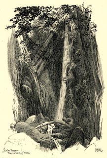 click to enlarge click to enlargePR0556.jpg printed at bottom left, right:- "Scale Force, the innermost recess / GORDON HOLME" item:- Dove Cottage : 2008.107.505 Image © see bottom of page |
|||||||||||||
|
|
||||||||||||||
| evidence:- | old print:- |
|||||||||||||
| source data:- | Print, colour lithograph? Scale Force, Cumberland, published by John Walker and Co,
Farringdon Street, London, late 19th century.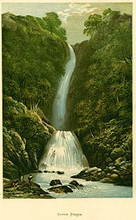 click to enlarge click to enlargePR0132.jpg printed at bottom left:- "JOHN WALKER &CO. / LONDON. / FARRINGDON ST." item:- Dove Cottage : 2008.107.132 Image © see bottom of page |
|||||||||||||
|
|
||||||||||||||
| evidence:- | outline view:- Black 1856 placename:- Scale Force |
|||||||||||||
| source data:- | Print, lithograph, Outline Views, Buttermere - Mountains as seen from the Knots near
the Hotel at Buttermere, and Mountains as seen at the Seat in Lanthwaite Wood, Scale
Hill, by J Flintoft, Keswick, Cumberland, engraved by R Mason, Edinburgh, Lothian,
about 1900. click to enlarge click to enlargeBC08E5.jpg "... 12 Situation of Scale Force ..." item:- JandMN : 37.19 Image © see bottom of page |
|||||||||||||
|
|
||||||||||||||
| evidence:- | old print:- Sylvan 1847 placename:- Scale Force |
|||||||||||||
| source data:- | Print, engraving, Scale Force, Loweswater, Cumberland, published by John Johnstone,
Paternoster Row, London, et al, 1847.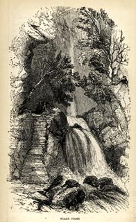 click to enlarge click to enlargeSYL153.jpg On p.207 of Sylvan's Pictorial Guide to the English Lakes. printed at lower left:- "BM" printed at bottom:- "SCALE FORCE." item:- Armitt Library : A1201.53 Image © see bottom of page |
|||||||||||||
|
|
||||||||||||||
| evidence:- | outline view:- Black 1841 (3rd edn 1846) placename:- Scale Force |
|||||||||||||
| source data:- | Print, engraving, outline view, Mountains as seen from The Knots near the Victoria
at Buttermere, and Mountains as seen at the Seat in Lanthwaite Wood, Scale Hill, by
J Flintoft, Keswick, Cumberland, engraved by R Mason, Edinburgh, Lothian, about 1846.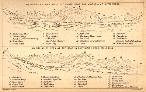 click to enlarge click to enlargeBC02E7.jpg "... 12 Situation of Scale Force ..." item:- JandMN : 32.11 Image © see bottom of page |
|||||||||||||
|
|
||||||||||||||
| evidence:- | old print:- Rose 1832-35 (vol.1 no.60) placename:- Scale Force |
|||||||||||||
| source data:- | Print, uncoloured engraving, Scale Force, Cumberland, drawn by Thomas Allom, engraved
by J C Bentley, published by Fisher, Son and Co, London, 1833.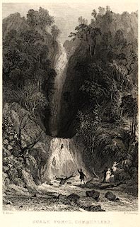 click to enlarge click to enlargePR0023.jpg vol.1 pl.60 in the set of prints, Westmorland, Cumberland, Durham and Northumberland Illustrated. A party of tourists in viewing the fall. printed at bottom left, right, centre:- "T. Allom. / J. C. Bentley. / SCALE FORCE, CUMBERLAND. / FISHER, SON &CO. LONDON, 1833." item:- Dove Cottage : 2008.107.23 Image © see bottom of page |
|||||||||||||
|
|
||||||||||||||
| evidence:- | old print with text:- Farington 1816 (plate 28) placename:- Scale Force |
|||||||||||||
| source data:- | Print, uncoloured engraving, Buttermere and Crommock Water, Buttermere, Cumberland,
drawn by Joseph Farington, engraved by F R Hay, published by T Cadell and W Davies,
Strand, London, 1815.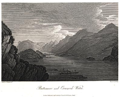 click to enlarge click to enlargePR0448.jpg Plate 28 in The Lakes of Lancashire, Westmorland, and Cumberland. printed at bottom left, right, centre:- "Drawn by J. Farington. / Engraved by F. R. Hay. / Buttermere and Crommock Water. / London, Published Septr. 15, 1815, by T. Cadell &W. Davies, Strand." The accompanying text is by Thomas Hartwell Horne:- "... one of these roaring cataracts appears in the back-ground of the present view. It is called Scale-force, and is two hundred feet perpendicular: the steep on both sides is covered with moss, fern, ash, and oak, which are all fed by the constant spray, and flourish in indescribable verdure. The delicacy of the effect is heightened by being in a narrow chasm, a hundred yards in the rock, before it rushes into the lower fall, from the point of which the best view is to be obtained." item:- private collection : 112 Image © see bottom of page |
|||||||||||||
|
|
||||||||||||||
| evidence:- | old print:- placename:- Scale Force |
|||||||||||||
| source data:- | Print, uncoloured engraving, Scale Force, Cumberland, drawn by Craig, engraved by
Pye, 1800s?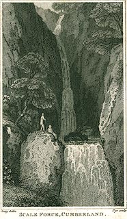 click to enlarge click to enlargePR0296.jpg printed at bottom left, right, centre:- "Craig delin. / Pye sculp / SCALE FORCE, CUMBERLAND." item:- Dove Cottage : 2008.107.296 Image © see bottom of page |
|||||||||||||
|
|
||||||||||||||
 BVG98.jpg Higher part. (taken 17.8.2011)  BVG97.jpg Lower part. (taken 17.8.2011) |
||||||||||||||
|
|
||||||||||||||
Lakes Guides menu.