 Old Cumbria Gazetteer
 |
 |
|
| Floutern Tarn, Loweswater | ||
| runs into:- |  Mosedale Beck Mosedale Beck |
|
|
|
||
| Floutern Tarn | ||
| civil parish:- | Loweswater (formerly Cumberland) | |
| county:- | Cumbria | |
| locality type:- | tarn | |
| coordinates:- | NY12461704 (etc) | |
| 1Km square:- | NY1217 | |
| 10Km square:- | NY11 | |
| altitude:- | 1237 feet | |
| altitude:- | 377m | |
|
|
||
| evidence:- | old map:- OS County Series (Cmd 68 8) placename:- Floutern Tarn |
|
| source data:- | Maps, County Series maps of Great Britain, scales 6 and 25
inches to 1 mile, published by the Ordnance Survey, Southampton,
Hampshire, from about 1863 to 1948. |
|
|
|
||
| evidence:- | possibly old map:- Sanson 1679 |
|
| source data:- | Map, hand coloured engraving, Ancien Royaume de Northumberland
aujourdhuy Provinces de Nort, ie the Ancient Kingdom of
Northumberland or the Northern Provinces, scale about 9.5 miles
to 1 inch, by Nicholas Sanson, Paris, France, 1679. click to enlarge click to enlargeSAN2Cm.jpg outline, shore shaded; lake item:- Dove Cottage : 2007.38.15 Image © see bottom of page |
|
|
|
||
| evidence:- | old map:- Donald 1774 (Cmd) placename:- Floutern Tarn |
|
| source data:- | Map, hand coloured engraving, 3x2 sheets, The County of Cumberland, scale about 1
inch to 1 mile, by Thomas Donald, engraved and published by Joseph Hodskinson, 29
Arundel Street, Strand, London, 1774.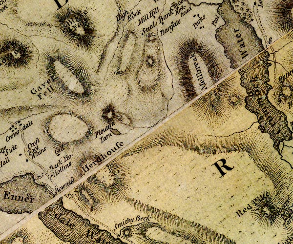 D4NY11NW.jpg "Floutern Tarn" lake item:- Carlisle Library : Map 2 Image © Carlisle Library |
|
|
|
||
| evidence:- | old text:- Green 1810 placename:- Fluttering Tarn |
|
| source data:- | Set of prints, soft ground etchings, Sixty Studies from Nature,
by William Green, Ambleside, Westmorland, drawn 1808-10,
published 1810. goto source page 71:- "Ennerdale Water may be taken by foot or horsemen from the inn at Buttermere, by keeping the road down the meadows, and passing Scale Force on the left to a little lake called Fluttering Tarn, which must likewise be kept on the left: ..." |
|
|
|
||
| evidence:- | old text:- Green 1814 placename:- Fluttering Tarn |
|
| source data:- | Set of prints, soft ground etchings, Sixty Small Prints, with
text, A Description of a Series of Sixty Small Prints, by
William Green, Ambleside, Westmorland, 1814. goto source page 22:- "... from the Inn at Buttermere, ... keeping the road down the" goto sourcepage 23:- "meadows, and passing Scale Force on the left, to a little lake called Fluttering Tarn, ..." |
|
|
|
||
| evidence:- | old map:- Otley 1818 placename:- Floutern |
|
| source data:- | Map, uncoloured engraving, The District of the Lakes,
Cumberland, Westmorland, and Lancashire, scale about 4 miles to
1 inch, by Jonathan Otley, 1818, engraved by J and G Menzies,
Edinburgh, Scotland, published by Jonathan Otley, Keswick,
Cumberland, et al, 1833.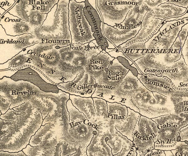 OT02NY11.jpg item:- JandMN : 48.1 Image © see bottom of page |
|
|
|
||
| evidence:- | descriptive text:- Otley 1823 (5th edn 1834) placename:- Floutern Tarn |
|
| source data:- | Guide book, A Concise Description of the English Lakes, the
mountains in their vicinity, and the roads by which they may be
visited, with remarks on the mineralogy and geology of the
district, by Jonathan Otley, published by the author, Keswick,
Cumberland now Cumbria, by J Richardson, London, and by Arthur
Foster, Kirkby Lonsdale, Cumbria, 1823; published 1823-49,
latterly as the Descriptive Guide to the English Lakes. goto source Page 39:- "... Floutern Tarn serves as a landmark in passing between Buttermere and Ennerdale; ..." |
|
|
|
||
| evidence:- | old map:- Garnett 1850s-60s H placename:- Floutern Tarn |
|
| source data:- | Map of the English Lakes, in Cumberland, Westmorland and
Lancashire, scale about 3.5 miles to 1 inch, published by John
Garnett, Windermere, Westmorland, 1850s-60s.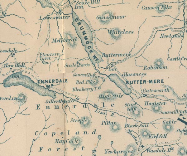 GAR2NY11.jpg "Floutern Tarn" outline with shore form lines, lake or tarn item:- JandMN : 82.1 Image © see bottom of page |
|
|
|
||
Lakes Guides menu.