 Accurate Map of the Matchless Lake of Derwent

|

|
|
|
map type:- Crosthwaite 1783-94 |
|
|
|
Series of maps, An Accurate Map of the Matchless Lake of
Derwent, of the Grand Lake of Windermere, of the Beautiful
Lake of Ullswater, of Broadwater or Bassenthwaite Lake, of
Coniston Lake, of Buttermere, Crummock and Loweswater Lakes,
and Pocklington's Island, by Peter Crosthwaite, Kendal,
Cumberland now Cumbria, 1783 to 1794.
Derwentwater, scale 3 inches to 1 mile, engraved by S Neele, published 1783; corrected and published 1788, 1794, 1809, 1819; reprinted 1863. Pocklington' Island, engraved by H Ashby, published 1783; corrected and published 1788, 1794, 1809. Windermere, scale 2 inches to 1 mile, engraved by H Ashby, published 1783; corrected and published 1788, 1794, 1809, 1819; reprinted 1863. Ullswater, scale 3 inches to 1 mile, engraved by H Ashby, published 1783; corrected and published 1788, 1794, 1809, 1819; reprinted 1863. Bassenthwaite Lake, scale 3 inches to 1 mile, engraved by S Neele, published 1785; corrected and published 1788, 1794, 1809, 1819; reprinted 1863. Coniston, scale 3 inches to 1 mile, engraved by J Ellis, published 1788; corrected and published 1794, 1809, 1819; reprinted 1863. Buttermere, Crummock Water and Loweswater, scale 3 inches to 1 mile, engraved by S Neele, published 1794; corrected and published 1809, 1819; reprinted 1863. |
||
|
(map example )
|
||
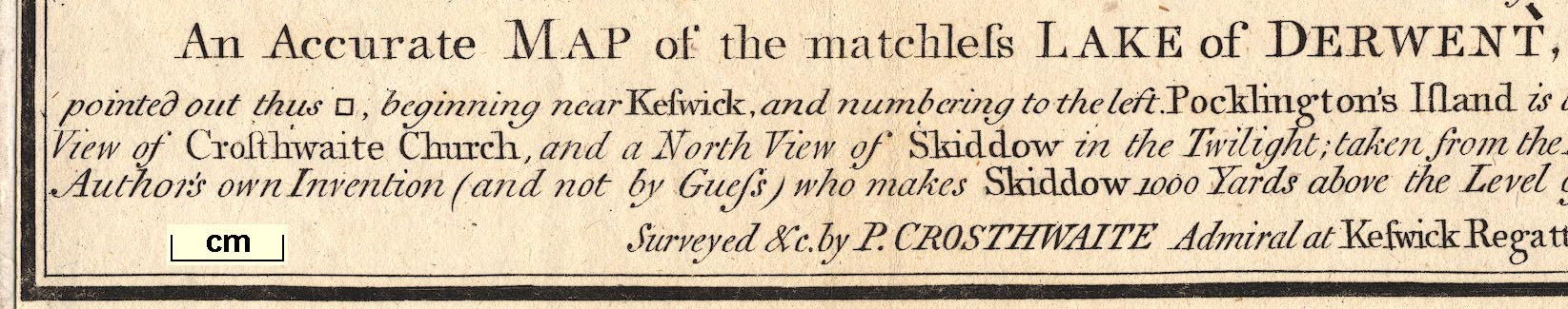
| map feature:- | compass rose & up is W & scale line & lat and long data & rivers & lakes & depth soundings & roads & settlements | |
| inscription:- |
printed lower centre
An Accurate MAP of the matchless LAKE of DERWENT, (situate in the most delightful Vale which perhaps ever Human Eye beheld) near KESWICK, CUMBERLAND, ... |
|
| scale line:- | 1 mile = 72 mm (approx) | |
| scale:- | 1 to 22000 ? | |
| wxh, map:- | 41.5x21cm | |
|
||
| references:- |
Crosthwaite, Peter & Rollinson, William (introduction):
1968: Series of Accurate Maps of the Principal Lakes of
Cumberland, Westmoreland and Lancashire: Graham, Frank
(Newcastle upon Tyne, Tyne and Wear):: facsimiles of each
map |
|
| sources:- |
Bicknell 1990 JandMN Collection Armitt Library Kendal Record Office |
|
| items seen (illustrated items in bold, * have map squares etc):- | ||

|
Armitt Library : 1959.191.2 -- map -- Accurate Map of Buttermere, Crummock and Loweswater Lakes * | |
|
|
Armitt Library : 1959.191.3 -- map -- Accurate Map of the Matchless Lake of Derwent * | |
|
|
Armitt Library : 1959.191.4 -- map -- Accurate Map of Broadwater or Bassenthwaite Lake * | |
|
|
Armitt Library : 1959.191.6 -- map -- Pocklington's Island | |
|
|
Armitt Library : 1959.191.7 -- map -- Accurate Map of the Beautiful Lake of Ullswater * | |
|
|
Armitt Library : ALMC2008.14.102 -- map -- Accurate Map of the Grand Lake of Windermere * | |
|
|
Carlisle Library : Map 216 -- map -- Accurate Map of Buttermere, Crummock and Loweswater Lakes | |
|
|
Carlisle Library : Map 217 -- map -- Accurate Map of Coniston Lake | |
|
|
Carlisle Library : Map 218 -- map -- Accurate Map of the Beautiful Lake of Ullswater | |
|
|
Carlisle Library : Map 219 -- map -- Accurate Map of the Grand Lake of Windermere | |
|
|
JandMN (182) -- map series -- Crosthwaite's Lakes -- Series of Accurate Maps of the Principal Lakes of Cumberland, Westmorland, and Lancashire | |
|
|
JandMN (182_1) -- map -- Accurate Map of the Matchless Lake of Derwent | |
|
|
JandMN (182_2) -- map -- Accurate Map of Broadwater or Bassenthwaite Lake | |
|
|
JandMN (182_3) -- map -- Accurate Map of Buttermere, Crummock and Loweswater Lakes | |
|
|
JandMN (182_4) -- map -- Accurate Map of the Grand Lake of Windermere | |
|
|
JandMN (182_5) -- map -- Accurate Map of Coniston Lake * | |
|
|
JandMN (182_6) -- map -- Accurate Map of the Beautiful Lake of Ullswater | |
|
|
JandMN (182_7) -- map -- Pocklington's Island | |
|
|
KendalRO : WDX 1113/2 -- map -- Accurate Map of the Grand Lake of Windermere | |
|
|
Keswick Museum : 2011.1 -- map -- Accurate Map of Broadwater or Bassenthwaite Lake | |