 Crosthwaite 1783-94

|

|
|
|
item:- Armitt Library : ALMC2008.14.102 image:- © see bottom of page |
click to enlarge |
|

|
menu with map squares and placename index | |
|
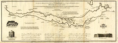
Map, uncoloured engraving, An Accurate Map of the Grand
Lake of Windermere, scale about 2 inches to 1 mile, by Peter
Crosthwaite, Keswick, Cumberland, 1783, version published
1819.
There are vignette views of Rydal old hall, Windermere Island House, Dove's nest, and Low-wood Inn. Thomas West's and Peter Crosthwaite's stations are marked. |
||
|
|
Crosthwaite 1783-94 | |
| map feature:- | vignettes & compass rose & up is W & scale line & rivers & lakes & depth soundings & settlements & roads | |
| inscription:- |
printed upper midde
An Accurate MAP of of the Grand Lake of WINDERMERE, being the largest in ENGLAND, situate in / WESTMORLAND and LANCASHIRE |
|
| inscription:- |
printed bottom right and centre
Engrav'd by H. Ashby. / London, Published as the Act directs 16th June 1783. Republished with additions as the Act directs 1 Decr. 1788, Republished again with other additions May the 1st. 1794, and Sold by Peter Crosthwaite the Author at his Museum Keswick / Republished with other additions March 20 1819. |
|
| scale line:- | 1 mile = 51.2 mm | |
| wxh, sheet:- | 62x23cm | |
| wxh, map:- | 594x213mm | |
| scale:- | 1 to 31000 ? (1 to 31433 from scale line assuming a statute mile) | |