 Crosthwaite 1783-94

|

|
|
|
item:- JandMN (182_2) image:- © see bottom of page |
click to enlarge |
|
|
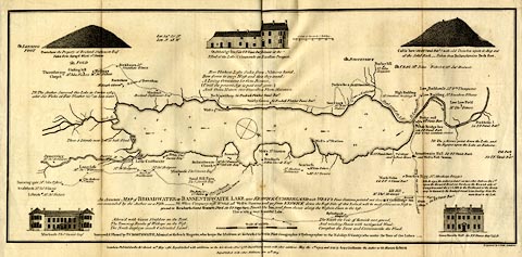
Map, uncoloured engraving, An Accurate Map of Broadwater
or Bassenthwaite Lake, scale about 3 inches to 1 mile, by
Peter Crosthwaite, Keswick, Cumberland, 1783, version
published 1809.
There are vignette views of Powter How, Ousebridge Inn, Castle How, Mirehouse, and Armathwaite Hall. Thomas West's and Peter Crosthwaite's stations are marked. |
||

|
Crosthwaite 1783-94 | |
| map feature:- | vignettes & compass rose & up is SW & scale line & lat and long data & rivers & lakes & depth soundings & settlements & roads | |
| inscription:- |
printed lower
An Accurate MAP of BROADWATER or BASSENTHWAITE LAKE near KESWICK, CUMBERLAND; ... |
|
| inscription:- |
printed bottom right and centre and right
Engraved by S. Neele London. / London, Publish'd as the Act directs 20th May 1785. Republished with additions, as the Act directs 1 Decr. 1788, Republished again with other additions May the 1st. 1794, and Sold by Peter Crosthwaite the Author at his Museum Keswick / Republished with other Additions June 20th. 1809. |
|
| scale line:- | 1 mile = 72.1 mm | |
| wxh, sheet:- | 46.5x23.5cm | |
| wxh, map:- | 452x211mm | |
| scale:- | 1 to 22000 ? (1 to 22321 from scale line assuming a statute mile) | |