 Crosthwaite 1783-94

|

|
|
|
item:- Armitt Library : 1959.191.2 image:- © see bottom of page |
click to enlarge |
|

|
menu with map squares and placename index | |
|
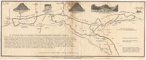
Map, uncoloured engraving, An Accurate Map of Buttermere,
Crummock and Loweswater Lakes, scale about 3 inches to 1
mile, by Peter Crosthwaite, Keswick, Cumberland, 1794,
version published 1800.
|
||
|
|
Crosthwaite 1783-94 | |
| map feature:- | vignettes & compass rose & up is SW & scale line & lat and long data & rivers & lakes & depth soundings & settlements & roads | |
| inscription:- |
printed lower left
An ACCURATE MAP of BUTTERMERE, CRUMMOCK & LOWES-WATER; SCALE FORCE &C; / ... / Surveyed & Planned by P. Crosthwaite (Proprietor of the Museum at Keswick) in June 1793. |
|
| inscription:- |
printed bottom centre and right
London, Published as the Act directs, May 7th. 1794 - and Sold by Peter Crosthwaite the Author, at his Museum Keswick. Republished with farther additions June 20th. 1800. / Neele Sculpt. 352 Strand |
|
| wxh, sheet (badly trimmed):- | 54.5x22cm | |
| wxh, map:- | 546x214mm | |
| inscription:- |
printed with scale line
A Scale of one Mile being 3 Inches |
|
| scale line:- | 1 mile = 74.1mm | |
| scale:- | 1 to 22000 ? (1 to 21719 from scale line assuming a statute mile) | |
|
|
notes | |