 Crosthwaite 1783-94

|

|
|
|
item:- Armitt Library : 1959.191.3 image:- © see bottom of page |
click to enlarge |
|

|
menu with map squares and placename index | |
|
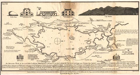
Map, uncoloured engraving, An Accurate Map of the
Matchless Lake of Derwent, ie Derwent Water, scale about 3
inches to 1 mile, by Peter Crosthwaite, Keswick, Cumberland,
1783, version published 1800.
|
||
|
|
Crosthwaite 1783-94 | |
| map feature:- | vignettes & compass rose & up is W & scale line & lat and long data & rivers & lakes & depth soundings & settlements & roads | |
| inscription:- |
printed lower
An Accurate MAP of the matchless LAKE of DERWENT, (Situate in the most delightful Vale which perhaps ever Human Eye beheld) near KESWICK, CUMBERLAND; ... |
|
| inscription:- |
printed bottom centre and right
London, Published as the Act directs, June 16th. 1783. Republished with Additions, as the Act directs, 1 Decr. 1788, [Re]published again, with Additions, May the 1st. 1794 - and Sold by Peter Crosthwaite, the Author, at his Museum Keswick. Republished with other A[ddi]tions June 20th. 1800. / Engraved by S. Neele. |
|
| scale line:- | 1 mile = 71.9mm | |
| wxh, sheet (badly trimmed):- | 41.5x22cm | |
| wxh, map:- | 413x207mm | |
| scale:- | 1 to 22000 ? (1 to 22383 from scale line assuming a statute mile) | |
|
|
notes | |