 Crosthwaite 1783-94

|

|
|

|
back to object record | |
|
Excellent general notes on the map series are given in a
book of facsimile reproductions:-
|
||
Crosthwaite, Peter & Rollinson, William (introduction): 1968: Series of Accurate Maps of the Principal Lakes of Cumberland, Westmorland and Lancashire: Graham, Frank (Newcastle upon Tyne, Tyne and Wear):: facsimiles of each map and an introductory essay |
||
| MAP FEATURES | ||
|
Labelled features are not systematically identified with
today's places as this will be done in a separate exercise.
|
||
|
|
||
|
title
map maker engraver |
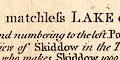
Printed in the lower part of the sheet:- An Accurate MAP of the matchless LAKE of DERWENT, (situate in the most delightful Vale which perhaps ever Human Eye beheld) near KESWICK, CUMBERLAND, ... Surveyed &c. by P. CROSTHWAITE Admiral at Keswick Regatta; who keeps the Museum at Keswick, & is Guide, Pilot, Geographer & Hydrographer to the Nobility and Gentry, who make the Tour of the Lakes. at the bottom:- London, Published as the Act directs, June 10th. 1783. Republished with Additions, as the Act directs. 1 Decr. 1788. Republished again with other Additions May the 1st. 1794, and Sold by Peter Crosthwaite, the Author at his Museum, Keswick. Republished with other Additions June 20th. 1809. and bottom right:- Engraved by S. Neele. |
|
|
|
||
| vignettes |
There are seven vignettes scenes, each with a caption, and extra notes in the text following the map title:- 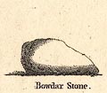
Bowdar Stone 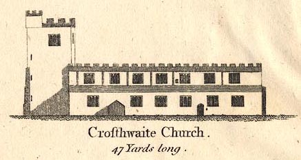
Crosthwaite Church. 47 Yards long. ... a S.W. View of Bowdar Stone, a North View of Crosthwaite Church, ... The Church and the Stone, are taken from one Scale; being 1/20th of an Inch to 1 Yard ... The Church 47 Yards long; and its highest Pinnacle, 20 Yards: Bowdar Stone 21 Yards long and 11 high. 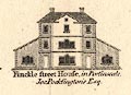
Finkle street House, in Portinscale, Jos. Pocklington's Esq. 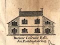
Barrow Cascade Hall, Jos. Pocklington's Esq. 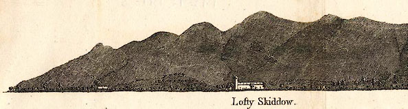
Lofty Skiddow ... a North View of Skiddow in the Twilight; taken from the Beautiful Field (Sir Michael le Flemings Bart.) ... 1/10 of an Inch to 100 Yards; by a Quadrant of the Author's own Invention (and not by Guess) who makes Skiddow 1000 Yards above the Level of Derwent. 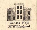
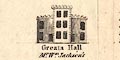
Greata Hall, Mr. Wm. Jackson's 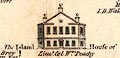
The Island House of Lieut. Col. Wm. Peachy |
|
|
|
||
|
orientation
compass rose up is W |
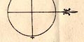
Printed in the middle of the lake is a minimal compass rose; circle, lines for cardinal directions, North marked by a spearhead, East marked by a cross. The map is printed with West at the top of the sheet; the lake flows from left to right across the sheet. |
|
|
|
||
|
scale line
scale |
Printed upper right is a:-
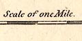
Scale of One Mile. chequered in furlongs. The 1 mile = 71.9 mm gives a scale 1 to 22383. The map scale is about:- 1 to 22000 3 inches to 1 mile |
|
|
|
||
| lat and long |
Printed upper left are:-
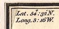
Lat. 54[d]: 32[m] N. Long. 3: 16 W. presumably for the centre of the lake. |
|
|
|
||
|
rivers
bridges waterfalls |
The rivers that feed and drain the lake are drawn by
double line with form lines; single wiggly lines are used
for most of the minor streams entering the lake. Rivers
might be labelled, eg:-
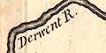
Derwent R. Greata River Grange River Mr West's Black Beck of Torver 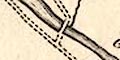
Bridges are marked where a road crosses and interrupts a stream. The Lake District has so many waterfalls that would be noticed in the south of England, that they are often taken for granted. The map points out falls particularly worthy of remark; though the criteria are no more clear than in a modern tourist guide. Round Derwent Water are:- Pocklington's Cascade & two Summer Houses on the stream on the east that passes Barrow Cascade Hall belonging to Joseph Pocklington. He had 'improved' this waterfall. And in the south east corner:- The Great Waterfall / R. Stephenson's Esq. which is Lodore Falls. The area to the north of the lake has a label about erosion:- Here lie the Splendid Spoils of Mountain Floods; Those Fertile Plains, brought Captive from their Sides, And yon Stupendous Chasms (Cloud high) have left; Bereft of Soil. |
|
|
|
||
|
lakes
islands depth soundings |
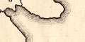
The dominant element of the map is the lake, drawn in outline with form lines. Only such surrounding topography as is useful or interesting to the visitor is plotted around the lake. Less is shown than could be expected, no relief or woodland or other vegetation, etc. The depth of the lake is given at various positions:- ... the Figures upon the Lake are Fathoms. the deepest part on the west, being 13.5 fathoms ie 81 feet. The flow of the lake is indicated:- The 3 arrows point down the Lake, ... Bays and peninsulas are clear, and islands are drawn and labelled:- 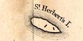
St. Herbert's I. Rampsholm I. Lord's Isld. Pocklington's Isld. and some smaller unnamed islands, many of which can be recognised. There are notes about the islands following the map title:- ... Pocklington's Island is the property of Lieut. Col. Peachy. Lord's Island, formerly Lord Derwentwater's; Rampsholm Island do.do. St. Herbert's Island, Sir Wilfrid Lawson's Bart. ... |
|
|
|
||
| relief |
Relief is not indicated, but notice the vignette view of
Skiddaw. There are also implications of heights in some
descriptions of stations, eg:-
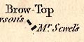
West's 4th. Station is Castle Crag one Mile south of Grange. and:- Swinside Hill 5th. Station |
|
|
|
||
| parks |
Parks are not shown, but notice the area on the south
east shore labelled:-
The Estate formerly Lord Derwentwater's extends along the winding shore from b to c and on a mean breadth half a mile inland. |
|
|
|
||
| county |
The lake is located in Cumberland.
|
|
|
|
||
| settlements |
A variety of places around the lake are noticed:-
|
|
|
towns
villages hamlets |
circle, buildings and towers; labelled in upright or
italic block caps:-
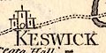
KESWICK GRANGE GREAT CROSTHWAITE ORMATHWAITE PORTINSCALE |
|
| houses |
block; labelled in italic lowercase text, house name and
owner's name, eg:-
Greata Hall / Mr. Wm. Jackson's Silver Hill / Ld. Wm. Gordon's Low Dore Hotel / R. Stephenson's Esq. |
|
|
|
||
| roads |
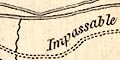
The map shows, drawn by solid or dotted double lines, routes for the tourist to see the lake. The route goes right round the lake, and might be commented upon, as for the three parallel ways on the east shore:- The only good road of the Three Impassable The New Road Impassable The circular tour route is from Keswick along the east shore to Grange, and back along the west shore through Portinscale to Keswick. The routes to the wider world are labelled, eg:- Road to Bowdar Stone, the Center & higher parts of Borrowdale To Bassenthwaite, Wigton and Carlisle Road to Watendlath |
|
|
|
||
| stations |
Stations, recommended viewpoints, are marked on the map
by a square symbol, labelled and described. The text
following the title states:-
... with West's eight Stations pointed out thus [square], beginning near Keswick, and numbering to the left. ... clockwise around the lake from Keswick:- 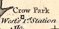
|
|
| station, Crow Park |
West no.1
Crow Park / West's 1st. Station |
|
| station, Cockshot Wood |
West no.2
Cock-shut / 2d. Station |
|
| station, Walla Crag |
West no.3
Common / 3d. Station |
|
| station, Castle Crag |
West no.4
West's 4th. Station is Castle Crag one Mile South of Grange which is off the map sheet. |
|
| station, Swinside |
West no.5
Swinside Hill / 5th. Station |
|
| West no.6 |
station, Fawe Park
Summit of Foe Park / Ld. Wm. Gordon's / 6th. Station |
|
| station, Crosthwaite Vicarage |
West no.7
7th. Station / A. Allason's Esq. / Vicarage |
|
| station, Latrigg |
West no.8
8th. Station on the Top of Latrigg |
|
|
Peter Crosthwaite also proposes his own stations:-
|
||
| station, Latrigg side |
Crosthwaite no.1
The Author's 1st. Station on the side of Latrigg also described in a descriptive text:- The Author's first Station for seeing the Vale in the best manner is by the side of the Horse Road he has made unto Latrigg; and about midway up; a little below a large Cross cut in the Ground as a mark for it. |
|
| station, Low Howray |
Crosthwaite no.2
The Author's 2d. Station in the middle of low Howray |
|
|
|
||
| miscellaneous | ||
|
|
||
|
springs
salt springs |
Near Manesty are marked:-
Salt Spring / Mr. Banks' Salt Spring |
|
|
|
||
|
mines
copper mines lead mines |
At the head of the lake there is a:-
Copper Mine / J Pocklington's Esqr. Lead Mine Do. [Mr. Banks's] |
|
Lakes Guides menu.