 Crosthwaite 1783-94

|

|
|
|
item:- JandMN (182_3) image:- © see bottom of page |
click to enlarge |
|
|
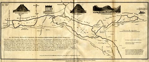
Map, uncoloured engraving, An Accurate Map of Buttermere,
Crummock and Loweswater Lakes, scale about 3 inches to 1
mile, by Peter Crosthwaite, Keswick, Cumberland, 1794,
version published 1809.
There are vignette views of Rannerdale Knot, Crosthwaite's Museum, Melbreak, Newlands and Buttermere Mountains, and Buttermere Chapel. Peter Crosthwaite's stations are marked. |
||

|
Crosthwaite 1783-94 | |
| map feature:- | vignettes & compass rose & up is SW & scale line & lat and long data & rivers & lakes & depth soundings & settlements & roads | |
| inscription:- |
printed lower left
An ACCURATE MAP of BUTTERMERE, CRUMMOCK & LOWES-WATER; SCALE FORCE &C; / ... / Surveyed & Planned by P. Crosthwaite (Proprietor of the Museum at Keswick) in June 1793. |
|
| inscription:- |
printed bottom right and centre
Neele Sculpt. 352 Strand / London, Published as the Act directs, May 7th. 1794 - and Sold by Peter Crosthwaite the Author, at his Museum Keswick. / Republished with farther additions June 20th. 1809. |
|
| scale line:- | 1 mile = 74.4 mm | |
| wxh, sheet:- | 55.5x23.5cm | |
| wxh, map:- | 547x214mm | |
| scale:- | 1 to 22000 ? (1 to 21631 from scale line assuming a statute mile) | |