 Crosthwaite 1783-94

|

|
|
|
item:- JandMN (182_1) image:- © see bottom of page |
click to enlarge |
|
|
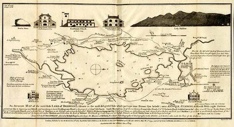
Map, uncoloured engraving, An Accurate Map of the
Matchless Lake of Derwent, ie Derwent Water, scale about 3
inches to 1 mile, by Peter Crosthwaite, Keswick, Cumberland,
1783, version published 1809.
There are vignette views of the Bowdar Stone, Finkle Street House, Crosthwaite Church, Barrow Cascade Hall, Lofty Skiddow, Greata Hall, and the isand house of Colonel Peachy. Thomas West's and Peter Crosthwaite's stations are marked. |
||

|
Crosthwaite 1783-94 | |
| map feature:- | vignettes & compass rose & up is W & scale line & lat and long data & rivers & lakes & depth soundings & settlements & roads | |
| inscription:- |
printed lower
An Accurate MAP of the matchless LAKE of DERWENT, (Situate in the most delightful Vale which perhaps ever Human Eye beheld) near KESWICK, CUMBERLAND; ... |
|
| inscription:- |
printed bottom right and centre
Engraved by S. Neele. / London, Published as the Act directs, June 16th. 1783. Republished with Additions, as the Act directs, 1 Decr. 1788, Republished again, with Additions, May the 1st. 1794 - and Sold by Peter Crosthwaite, the Author, at his Museum Keswick. / Republished with other Additions June 20th. 1809. |
|
| scale line:- | 1 mile = 71.3 mm | |
| wxh, sheet:- | 42x23.5cm | |
| wxh, map:- | 409x207mm | |
| scale:- | 1 to 23000 ? (1 to 22571 from scale line assuming a statute mile) | |