 Crosthwaite 1783-94

|

|
|
|
item:- Keswick Museum : 2011.1 image:- © see bottom of page |
click to enlarge |
|
|
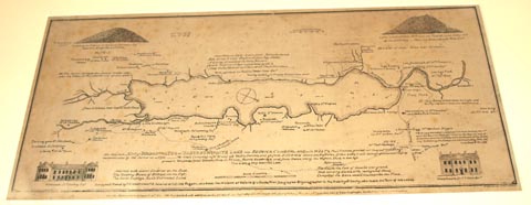
Map, uncoloured manuscript, An Accurate Map of Broadwater
or Bassenthwaite Lake, scale about 3 inches to 1 mile, by
Peter Crosthwaite, Keswick, Cumberland, 1783, version
published 1794.
There are vignette views of Powter How, Ousebridge Inn, Castle How, Mirehouse, and Armathwaite Hall. Thomas West's and Peter Crosthwaite's stations are marked. This is a manuscript version of the published map - either the manuscript edited from the 1788 edition presumably by Peter Crosthwaite, to be sent to be engraved for the 1794 edition; or a copy by an unknown hand for some unguessed purpose. I have only to hand images of the 1800 and 1809 editions with which to make comparisons. There are differences, for example - the scale line is chequered bwbwbwbw in the ms, but wbwbwbwb in the 1809 print; in the title line 1 at the end '... & Ousebridge' in the ms, '... & Ousebridge Inn' in the 1809 print; in the title line 3 middle '... Fourth Ousebridge and ...' in the ms, '... Fourth the Inn, and ...' in the 1809 print. There are probably other minor differences. It would be interesting to find 1788 and 1794 editions of the map to make detail comparisons. |
||

|
Crosthwaite 1783-94 | |
| map feature:- | vignettes & compass rose & up is SW & scale line & lat and long data & rivers & lakes & depth soundings & settlements & roads | |
| inscription:- |
ms lower centre
An Accurate MAP of BROADWATER or BASSENTHWAITE LAKE near KESWICK, CUMBERLAND; ... |
|
| inscription:- |
ms bottom right and centre
[Engraved by S. Neele London. / London, Published as the Act directs 20th May 1785. Republished with additions, as the Act directs 1 Decr. 1788, Republished again with other additions May the 1st. 1794, and Sold by Peter Crosthwaite the Author at his Museum Keswick.] |
|
| scale line:- | 1 mile = 72.8 mm (about) | |
| wxh, map:- | 455x208mm (about) | |
| scale:- | 1 to 22000 ? (1 to 22106 from scale line assuming a statute mile) | |