 Crosthwaite 1783-94

|

|
|
|
item:- JandMN (182_6) image:- © see bottom of page |
click to enlarge |
|
|
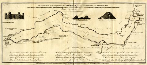
Map, uncoloured engraving, Accurate Map of the Beautiful
Lake of Ullswater, scale about 3 inches to 1 mile, by Peter
Crosthwaite, Keswick, Cumberland, 1783, version published
1809.
There are vignette views of Lyulph's Tower, Pikes of Place Fell, and Dunmallard Hill. Thomas West's and Peter Crosthwaite's stations are marked. |
||

|
Crosthwaite 1783-94 | |
| map feature:- | vignettes & compass rose & up is SE & scale line & lat and long data & rivers & lakes & depth soundings & settlements & roads | |
| inscription:- |
printed upper centre
An Accurate MAP of the beautiful Lake of ULLS-WATER, situate in CUMBERLAND and WESTMORLAND. / P. CROSTHWAITE, ... Surveyed Ulls-water in April 1783, & constructed this MAP accordingly. |
|
| inscription:- |
printed bottom right and centre
Engrav'd by H. Ashby. / London Published as the Act directs, June 16th. 1783. Republished with additions as the Act directs, 1. Decr. 1788. Republished again with other additions May the 1st. 1794. - and Sold by Peter Crosthwaite, at his Museum Keswick. / Republished with further additions June 20th. 1809. |
|
| scale line:- | 1 mile = 71.9 mm | |
| wxh, sheet:- | 52x23.5cm | |
| wxh, map:- | 510x214mm | |
| scale:- | 1 to 22000 ? (1 to 22383 from scale line assuming a statute mile) | |