 Crosthwaite 1783-94

|

|
|
|
item:- JandMN (182_5) image:- © see bottom of page |
click to enlarge |
|

|
menu with map squares and placename index | |
|
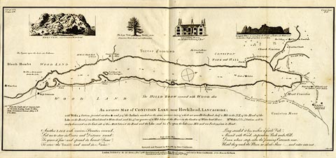
Map, uncoloured engraving, An Accurate Map of Coniston
Lake, scale about 3 inches to 1 mile, by Peter Crosthwaite,
Keswick, Cumberland, 1788, version published 1809.
There are vignette views of Raven Crag, Yew Tree at Waterhead, Coniston Hall, and the Langdale Pikes. Thomas West's and Peter Crosthwaite's stations are marked. |
||
|
|
Crosthwaite 1783-94 | |
| map feature:- | vignettes & compass rose & up is W (WNW) & scale line & lat and long data & rivers & lakes & depth soundings & settlements & roads | |
| inscription:- |
printed lower middle
An Accurate MAP of CONISTON LAKE, near Hawkshead, LANCASHIRE; / ... |
|
| inscription:- |
printed lower centre
Surveyed and Planned in May, 1788, by Peter Crosthwaite. |
|
| inscription:- |
printed lower right
J. Ellis sculp |
|
| inscription:- |
printed bottom right and centre
London Published as the Act directs , 1 Decr. 1788. Republished with additions May the 1st. 1794 - and Sold by Peter Crosthwaite at his Museum Keswick. / Republished with farther additions June 20th. 1809. |
|
| scale line:- | 1 mile = 71.5 mm | |
| wxh, sheet:- | 49x23.5cm | |
| wxh, map:- | 481x210mm | |
| scale:- | 1 to 23000 ? (1 to 22508 from scale line assuming a statute mile) | |