Old Cumbria Gazetteer
 |
 |
|
||
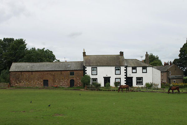
| Kirkby Thore | ||||
| civil parish:- | Kirkby Thore (formerly Westmorland) | |||
| county:- | Cumbria | |||
| locality type:- | locality | |||
| locality type:- | buildings | |||
| coordinates:- | NY63892568 (etc) | |||
| 1Km square:- | NY6325 | |||
| 10Km square:- | NY62 | |||
| latitude; longitude:- | 2d 33.5m W; 54d 37.5m N | |||
|
|
||||
| evidence:- | old map:- OS County Series (Wmd 9 1) placename:- Kirkby Thore |
|||
| source data:- | Maps, County Series maps of Great Britain, scales 6 and 25
inches to 1 mile, published by the Ordnance Survey, Southampton,
Hampshire, from about 1863 to 1948. |
|||
|
|
||||
| evidence:- | old map:- Saxton 1579 placename:- Kirkby Thuet |
|||
| source data:- | Map, hand coloured engraving, Westmorlandiae et Cumberlandiae Comitatus ie Westmorland
and Cumberland, scale about 5 miles to 1 inch, by Christopher Saxton, London, engraved
by Augustinus Ryther, 1576, published 1579-1645.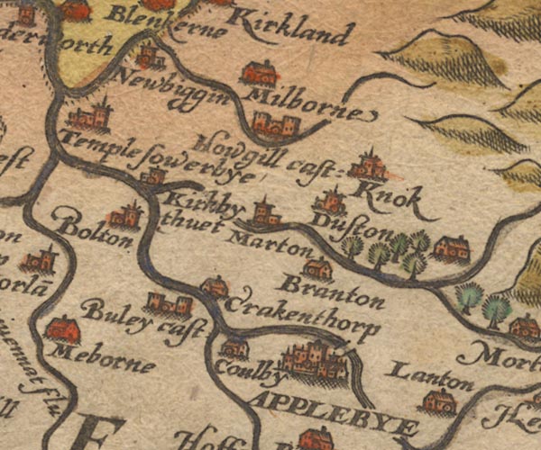 Sax9NY62.jpg Church, symbol for a parish or village, with a parish church. "Kirkby thuet" item:- private collection : 2 Image © see bottom of page |
|||
|
|
||||
| evidence:- | old map:- Keer 1605 placename:- Kirkby Thuot |
|||
| source data:- | Map, hand coloured engraving, Westmorland and Cumberland, scale
about 16 miles to 1 inch, probably by Pieter van den Keere, or
Peter Keer, about 1605 edition perhaps 1676. click to enlarge click to enlargeKER8.jpg "Kirkby [thuot]" dot, circle and tower; village item:- Dove Cottage : 2007.38.110 Image © see bottom of page |
|||
|
|
||||
| evidence:- | old map:- Speed 1611 (Wmd) placename:- Kirkby Thore |
|||
| source data:- | Map, hand coloured engraving, The Countie Westmorland and
Kendale the Cheif Towne, scale about 2.5 miles to 1 inch, by
John Speed, 1610, published by George Humble, Popes Head Alley,
London, 1611-12.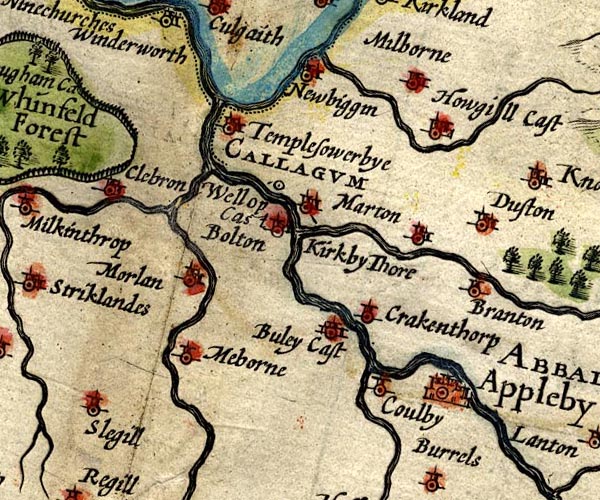 SP14NY62.jpg "Kirkby Thore" circle, building and tower; noice the line indicating the label item:- Armitt Library : 2008.14.5 Image © see bottom of page |
|||
|
|
||||
| evidence:- | old map:- Jenner 1643 placename:- Kirkbythuet |
|||
| source data:- | Table of distances, with map, hand coloured engraving,
Westmerland ie Westmorland, scale about 16 miles to 1 inch,
engraved by Jacob van Langeren, published by Thomas Jenner,
Cornhill, London, 1643. JEN3Sq.jpg "Kirkbythuet" dot, circle, tower item:- private collection : 52.Wmd Image © see bottom of page |
|||
|
|
||||
| evidence:- | old map:- Jansson 1646 placename:- Kirkby Thuet |
|||
| source data:- | Map, hand coloured engraving, Cumbria and Westmoria, ie
Cumberland and Westmorland, scale about 3.5 miles to 1 inch, by
John Jansson, Amsterdam, Netherlands, 1646. JAN3NY62.jpg "Kirkby thuet" Buildings and tower. item:- JandMN : 88 Image © see bottom of page |
|||
|
|
||||
| evidence:- | old map:- Seller 1694 (Wmd) placename:- Kerkby Thuet |
|||
| source data:- | Map, hand coloured engraving, Westmorland, scale about 8 miles
to 1 inch, by John Seller, 1694. click to enlarge click to enlargeSEL7.jpg "Kerkby thuet" circle, italic lowercase text; settlement or house item:- Dove Cottage : 2007.38.87 Image © see bottom of page |
|||
|
|
||||
| evidence:- | old map:- Morden 1695 (Wmd) placename:- Kirby Thure |
|||
| source data:- | Map, hand coloured engraving, Westmorland, scale about 2.5 miles to 1 inch, by Robert
Morden, published by Abel Swale, the Unicorn, St Paul's Churchyard, Awnsham, and John
Churchill, the Black Swan, Paternoster Row, London, 1695.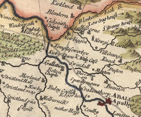 MD10NY62.jpg "Kirby Thure &Whelp Cast / Galla[tum]" Circle, building and tower; the roman name is engraved over a poorly erased label for Whelp Castle. item:- JandMN : 24 Image © see bottom of page |
|||
|
|
||||
| evidence:- | old text:- Gents Mag placename:- Kirkby Thor item:- roman altar; roman inscription; placename, Kirkby Thore |
|||
| source data:- | Magazine, The Gentleman's Magazine or Monthly Intelligencer or
Historical Chronicle, published by Edward Cave under the
pseudonym Sylvanus Urban, and by other publishers, London,
monthly from 1731 to 1922. goto source goto sourceGentleman's Magazine 1738 p.417 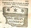 click to enlarge click to enlargeG738E01.jpg "Fragment of an Altar to Serapis, in a Wall at Kirkby Thor, in Westmorland." "The above Figure is a Fragment of a Roman Altar to Jupiter Serapis, lately taken out of the Back of an Oven at Kirkby Thor in Westmoreland, and now plac'd in a Stone Wall in the Town Street; by the Asterisks placed at the Top, the Deity having such a Mark in the AEgyptian Ceremonies, the Dedicator seems to have been an AEgyptian, train'd up at Rome; 'tis a small portable Altar, and, I believe, the only one dedicated to that Idol in Britain." "The following is in the Wall of a House at the same Place, but the Inscription is common tho' imperfect." 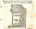 click to enlarge click to enlargeG738E02.jpg "Fragment of a Roman Altar to the Great Jupiter, found in the same Place, in the Wall of House." "The Village, yet, retains the Name of the Saxon Idol Thor, from whence Thursday is call'd, is remarkable for a very considerable Vestige of a Roman Camp, and several other Inscriptions and Ruins, which I had not Leisure to examine, but may be the Subject of some future Attempt." "Yours, CARLEOLENSIS." |
|||
|
|
||||
| evidence:- | old map:- Badeslade 1742 placename:- Kirby Thume |
|||
| source data:- | Map, uncoloured engraving, A Map of Westmorland North from
London, scale about 10 miles to 1 inch, with descriptive text,
by Thomas Badeslade, London, engraved and published by William
Henry Toms, Union Court, Holborn, London, 1742. click to enlarge click to enlargeBD12.jpg "Kirby Thume &Whelp Cast." circle with a flag, italic lowercase text; village or hamlet item:- Dove Cottage : 2007.38.62 Image © see bottom of page |
|||
|
|
||||
| evidence:- | old map:- Simpson 1746 map (Wmd) placename:- Kirby Thurce |
|||
| source data:- | Map, uncoloured engraving, Westmorland, scale about 8 miles to 1
inch, printed by R Walker, Fleet Lane, London, 1746. SMP2NYR.jpg "Kirby Thurce and Whelp C." Building. item:- Dove Cottage : 2007.38.59 Image © see bottom of page |
|||
|
|
||||
| evidence:- | old text:- Gents Mag item:- roman inscription; inscription, roman |
|||
| source data:- | Magazine, The Gentleman's Magazine or Monthly Intelligencer or
Historical Chronicle, published by Edward Cave under the
pseudonym Sylvanus Urban, and by other publishers, London,
monthly from 1731 to 1922. goto source Gentleman's Magazine 1753 p.270 "... ..." "P.S. There are two Roman inscriptions at a country village, call'd Kirkby Thore in Westmorland, which never yet have been published; the one, in a stone wall near the house of the Rev. Mr Atkinson, rector of the church, beginning with ANTONIA &c. The other in a stone wall belonging to Dr Green against the Town street, beginning with the words JOVI SERAPI, &c. but I had not time to copy them, tho' legible enough. There are likewise other Roman letters and sculptures, upon several of the door lintels, in the same town, which Mr Horseley has omitted." "Headston Howe, Dec. 16 1752." "... ..." |
|||
|
|
||||
| evidence:- | old map:- Bowen and Kitchin 1760 placename:- Kirkby Thore |
|||
| source data:- | Map, hand coloured engraving, A New Map of the Counties of
Cumberland and Westmoreland Divided into their Respective Wards,
scale about 4 miles to 1 inch, by Emanuel Bowen and Thomas
Kitchin et al, published by T Bowles, Robert Sayer, and John
Bowles, London, 1760. BO18NY52.jpg "Kirkby Thore / R" circle, building and tower, rectory item:- Armitt Library : 2008.14.10 Image © see bottom of page |
|||
|
|
||||
| evidence:- | old map:- Jefferys 1770 (Wmd) placename:- Kirkbythore |
|||
| source data:- | Map, 4 sheets, The County of Westmoreland, scale 1 inch to 1
mile, surveyed 1768, and engraved and published by Thomas
Jefferys, London, 1770. J5NY62NW.jpg "Kirkbythore" blocks, labelled in upright lowercase text; settlement; town? item:- National Library of Scotland : EME.s.47 Image © National Library of Scotland |
|||
|
|
||||
| evidence:- | old text:- Pennant 1773 placename:- Kirkby Thore item:- coin |
|||
| source data:- | Book, A Tour from Downing to Alston Moor, 1773, by Thomas
Pennant, published by Edward Harding, 98 Pall Mall, London, 1801. goto source Pennant's Tour 1773, page 149 "At a small distance to the right is the village of Kirkby-Thore. The addition is attributed to the supposition of a temple, dedicated to the Saxon THOR, having stood on the spot. This Deity was represented as a regal figure with crown and sceptre, and a Glory of twelve stars around his head. He was the Chief of the heavenly power, the Jupiter Tanarus of our German ancestors, the Prince of the Air, the Director of Thunder, Lightning and Tempests; the Dispenser of Fair Weather, and consequent Plenty:- to" goto sourcePennant's Tour 1773, page 150 "whom Thursday was dedicated under the name of Thor's-day, and more expressively of his qualities under that of Thunres-deag, and in the Netherlands in more modern times Dunders-dagh." "A very curious coin, or perhaps amulet, was discovered in the beginning of this century, which fully shews the form in which this Deity was figured. It has, on one side, his head with the Glory around, and a sceptre in his hand: on the reverse are Runic characters, Thur gut Laetis, i.e. The Face of the God Thor: it was of silver, and the size of a silver groat. Such pieces it was customary for the northern nations to strike, with their Gods represented on them in form of a human face; and these they kept by them as tutelar deities, and preservatives from all ills." |
|||
|
|
||||
| evidence:- | descriptive text:- West 1778 (11th edn 1821) |
|||
| source data:- | Guide book, A Guide to the Lakes, by Thomas West, published by
William Pennington, Kendal, Cumbria once Westmorland, and in
London, 1778 to 1821. goto source Addendum; Mr Gray's Journal, 1769 Page 200:- "... Passed Kirkby-thore, ... crossed the Eden and the Eamont with its green vale, ... [to] Penrith ..." |
|||
|
|
||||
| evidence:- | old text:- Camden 1789 (Gough Additions) placename:- Kirkby Thor item:- coin; runes |
|||
| source data:- | Book, Britannia, or A Chorographical Description of the Flourishing Kingdoms of England,
Scotland, and Ireland, by William Camden, 1586, translated from the 1607 Latin edition
by Richard Gough, published London, 1789. goto source Page 158:- "..." "The manor house, as well as most of the town of Kirkby Thor, have been built out of the remains of Whelp castle, of which there are now scarce any remains. ..." goto sourcePage 159:- "..." "Kirkby Thor has been supposed to retain the name of the God Thor, whose figure was thought to be found on a singular coin late in Mr. Thoresby's Museum. The characters on the reverse are Runic and were read by Dr. Hickes, Thor gut luntis, and explained by bishop Nicolson the face of the God Thor, but by Dr. Hickes Thor the national God, to whom also the moon and stars concurred to accompany them. But it was much more probably illustrated by the learned Keder, member of the college of antiquities at Stockholm, who published a critical essay on it at Leipsic, 1703, 4to. See also his "Runae in nummis vetustis," shewing the head to be the figure of our Saviour, and the inscription, the place, and mint-master's names Thorgut Luntis, i.e. Thorgut London, whether of London in England or Lunden in Sweden uncertain. The cross at the head of the inscription and in the centre of the reverse are evidently Christian, and Keder produces other similar coins to this, which so much puzzled all preceding antiquaries, who, when they had once set up the idea of the god Thor, tortured every thing to their system as much as Leibnitz to his, that it was struck by or for Thurgot, a Danish admiral, who Dithmar says blocked up London 1016." |
|||
|
|
||||
| evidence:- | old map:- Cary 1789 (edn 1805) placename:- Kirkbythore |
|||
| source data:- | Map, uncoloured engraving, Westmoreland, scale about 2.5 miles
to 1 inch, by John Cary, London, 1789; edition 1805. CY24NY62.jpg "Kirkbythore" block/s, labelled in italic lowercase; house, or hamlet item:- JandMN : 129 Image © see bottom of page |
|||
|
|
||||
| evidence:- | old map:- Cooke 1802 placename:- Kirbythore |
|||
| source data:- | Map, Westmoreland ie Westmorland, scale about 12 miles to 1
inch, by George Cooke, 1802, published by Sherwood, Jones and
Co, Paternoster Road, London, 1824. click to enlarge click to enlargeGRA1Wd.jpg "Kirbythore" blocks, italic lowercase text, village, hamlet, locality item:- Hampshire Museums : FA2000.62.4 Image © see bottom of page |
|||
|
|
||||
| evidence:- | old map:- Laurie and Whittle 1806 placename:- Kirkbythore |
|||
| source data:- | Road map, Continuation of the Roads to Glasgow and Edinburgh,
scale about 10 miles to 1 inch, by Nathaniel Coltman? 1806,
published by Robert H Laurie, 53 Fleet Street, London, 1834. click to enlarge click to enlargeLw21.jpg "Kirkbythore 274¼" village or other place; distance from London item:- private collection : 18.21 Image © see bottom of page |
|||
|
|
||||
| evidence:- | old map:- Cooper 1808 placename:- Kirbythore |
|||
| source data:- | Map, hand coloured engraving, Westmoreland ie Westmorland, scale
about 9 miles to 1 inch, by H Cooper, 1808, published by R
Phillips, Bridge Street, Blackfriars, London, 1808. click to enlarge click to enlargeCOP4.jpg "Kirbythore" circle; village or hamlet item:- Dove Cottage : 2007.38.53 Image © see bottom of page |
|||
|
|
||||
| evidence:- | old map:- Wallis 1810 (Wmd) placename:- Kirkbythore |
|||
| source data:- | Road map, Westmoreland, scale about 19 miles to 1 inch, by James
Wallis, 77 Berwick Street, Soho, 1810, published by W Lewis,
Finch Lane, London, 1835? click to enlarge click to enlargeWAL5.jpg "Kirkbythore" village, hamlet, house, ... item:- JandMN : 63 Image © see bottom of page |
|||
|
|
||||
| evidence:- | old map:- Ford 1839 map placename:- Kirkby Thore |
|||
| source data:- | Map, uncoloured engraving, Map of the Lake District of
Cumberland, Westmoreland and Lancashire, scale about 3.5 miles
to 1 inch, published by Charles Thurnam, Carlisle, and by R
Groombridge, 5 Paternoster Row, London, 3rd edn 1843. FD02NY62.jpg "Kirkby Thore" item:- JandMN : 100.1 Image © see bottom of page |
|||
|
|
||||
| evidence:- | old map:- Garnett 1850s-60s H placename:- Kirkby Thorpe |
|||
| source data:- | Map of the English Lakes, in Cumberland, Westmorland and
Lancashire, scale about 3.5 miles to 1 inch, published by John
Garnett, Windermere, Westmorland, 1850s-60s.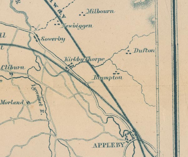 GAR2NY62.jpg "Kirkby Thorpe" blocks, settlement item:- JandMN : 82.1 Image © see bottom of page |
|||
|
|
||||
| evidence:- | site plan:- Historical Monuments 1936 |
|||
| source data:- | Site plan, uncoloured lithograph, Kirkby Thore Plan Showing Roman Sites, Kirkby Thore,
Westmorland, scale about 1 to 5000, about 12.5 inches to 1 mile, published by Royal
Commission on Historical Monuments England, London, 1936.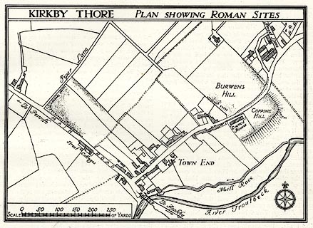 click to enlarge click to enlargeHMW091.jpg On p.145 of the Inventory of the Historical Monuments in Westmorland. printed, top "KIRKBY THORE PLAN SHOWING ROMAN SITES" item:- Armitt Library : A745.91 Image © see bottom of page |
|||
|
|
||||
 Post Office maps Post Office maps |
||||
|
|
||||
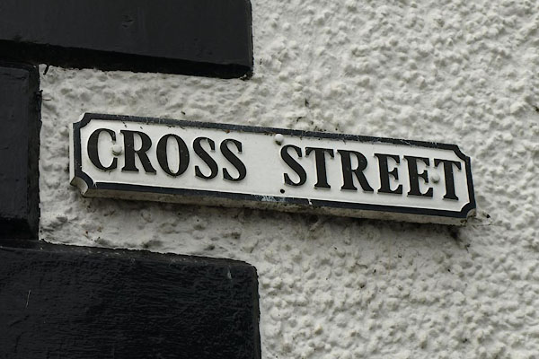 BXF16.jpg Street name:- "CROSS STREET" (taken 31.8.2012) |
||||
|
|
||||
| places:- |
|
|||
|
||||
|
||||
|
||||
|
||||
|
||||
|
||||
|
||||
|
||||
|
||||
|
||||
|
||||
|
||||
|
||||
|
||||
|
||||
|
||||
|
||||
|
||||
|
||||
|
||||
|
||||
|
||||
|
||||
|
||||
|
||||
|
||||
|
||||
|
||||
|
||||
|
||||
|
||||
|
||||
|
||||
|
||||
|
||||
|
||||
|
||||
|
||||
|
||||
|
||||
|
||||
Lakes Guides menu.