 Old Cumbria Gazetteer
 |
 |
|
||||||||||||||||||||||||||||||||||||||||||||||||||||||||||||||||||||||||||||||||||||||||||||||
| included in:- |
 road, London to Carlisle road, London to Carlisle |
|||||||||||||||||||||||||||||||||||||||||||||||||||||||||||||||||||||||||||||||||||||||||||||||
| road, Lancaster to Carlisle | ||||||||||||||||||||||||||||||||||||||||||||||||||||||||||||||||||||||||||||||||||||||||||||||||
| Lancaster to Carlisle | ||||||||||||||||||||||||||||||||||||||||||||||||||||||||||||||||||||||||||||||||||||||||||||||||
| Carlisle to Lancaster | ||||||||||||||||||||||||||||||||||||||||||||||||||||||||||||||||||||||||||||||||||||||||||||||||
| locality:- | Lancaster | |||||||||||||||||||||||||||||||||||||||||||||||||||||||||||||||||||||||||||||||||||||||||||||||
| county:- | Lancashire | |||||||||||||||||||||||||||||||||||||||||||||||||||||||||||||||||||||||||||||||||||||||||||||||
| locality type:- | route | |||||||||||||||||||||||||||||||||||||||||||||||||||||||||||||||||||||||||||||||||||||||||||||||
| locality:- | Carlisle | |||||||||||||||||||||||||||||||||||||||||||||||||||||||||||||||||||||||||||||||||||||||||||||||
| civil parish:- | Carlisle (formerly Cumberland) | |||||||||||||||||||||||||||||||||||||||||||||||||||||||||||||||||||||||||||||||||||||||||||||||
| county:- | Cumbria | |||||||||||||||||||||||||||||||||||||||||||||||||||||||||||||||||||||||||||||||||||||||||||||||
| locality type:- | route | |||||||||||||||||||||||||||||||||||||||||||||||||||||||||||||||||||||||||||||||||||||||||||||||
|
|
||||||||||||||||||||||||||||||||||||||||||||||||||||||||||||||||||||||||||||||||||||||||||||||||
| route parts:- |  Lancaster to Kendal, Easterly route via Burton Lancaster to Kendal, Westerly route via Milnthorpe Kendal to Shap Shap to Penrith Penrith to Carlisle Lancaster to Kendal, Easterly route via Burton Lancaster to Kendal, Westerly route via Milnthorpe Kendal to Shap Shap to Penrith Penrith to Carlisle |
|||||||||||||||||||||||||||||||||||||||||||||||||||||||||||||||||||||||||||||||||||||||||||||||
|
|
||||||||||||||||||||||||||||||||||||||||||||||||||||||||||||||||||||||||||||||||||||||||||||||||
| evidence:- | old map:- Ogilby 1699 map (edn 1712) |
|||||||||||||||||||||||||||||||||||||||||||||||||||||||||||||||||||||||||||||||||||||||||||||||
| source data:- | Road map, uncoloured engraving, a New Mapp of the Roads of England, by John Ogilby,
published by William Bray, Exeter Court, Strand, London, 1712. "London and Carlisle Road" 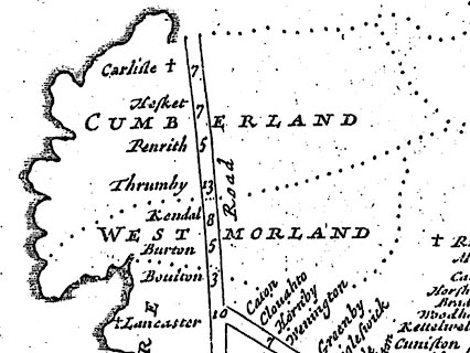 click to enlarge click to enlargeOGY7Cm.jpg item:- private collection : 263.1 Image © see bottom of page |
|||||||||||||||||||||||||||||||||||||||||||||||||||||||||||||||||||||||||||||||||||||||||||||||
|
|
||||||||||||||||||||||||||||||||||||||||||||||||||||||||||||||||||||||||||||||||||||||||||||||||
| evidence:- | old text:- Ogilby 1699 (edn 1712) |
|||||||||||||||||||||||||||||||||||||||||||||||||||||||||||||||||||||||||||||||||||||||||||||||
| source data:- | Road book, itineraries and map, The Traveller's Guide, by John
Ogilby, published by Abel Swall, Tim Child, White Hart, and R
Knaplock, the Angel and Crown, St Paul's Churchyard, London,
1699. OGY7p072.txt page 72 Distances from London "LONDON to CARLILE in Cumberland. PART II." "Commencing at Garstang in Lancashire, and Extending to CARLISLE." "Containing 78 Miles 3 Furlongs." "In which the following Turnings are to be avoided." "At 233'4 a little beyond Lancaster, the Left. 267'2 the Right to Applebey. 274'0 the Right to Strickland. 283'6 the Right to Salkeld, and 4 F. farther, the Right to Moss. 298'6 the Left at the End of Carlton." "... ent'ring Lancaster at 231'4 on the S-side of Lunu flv. a Place of good Antiquity, suppos'd to be the Longovicunt in the Notitia's, containing several handsom Streets, with a large Ch. which together with the Castle, where are kept the general Assizes and County-Gaol, stand on the N.W. of the T. 'Tis a Corp. govern'd by a Mayor, 2 Bayliffs, 6 Mayor-Peers or Brethren, 24 Burgesses, &c. Statutes-Merchants are here acknowledged, and Parl-Men elected; This T. has a great Mt. on Saturd. for Corn, Cattel, Fish, (especially Salmon) and other Provisions; and has given Title of Earl and Duke to several Princes of the Royal Blood for some Centuries of Years." "Thence pass the River over a Fair Stone-Br. at 235'7 to Slyne-V. and 7F. farther, to Burton of near 3F. a good Thorough-fare. At 239'3 come to Cranford-V. Whence over Dare-Br. and by Lighton-Hall on the Right, at 243'5 enter Westmoreland, and 6F. beyond Burton of 2F. on the South of Farleton-Knot; an indifferent Thorough-fare with a Market on Tuesdays." "This is reckon'd the Mid-way between Lancaster and Kendal, the rest very Mountainous. Then passing between Holm-Ch. and P. and 1M. beyond Farendon, upon Holton-Crag about 2F. to the Right; a direct R. crossing 2 or 3 Brooks leads over Sallat-Brow and by Grove-Chappel on the Right, at 263M. to Sidwich alias Sigiswick-V. At 244 M. com to Norcliff-V. of 2F. and to Kendal at 256'1 extending 1M. on the Road." "Kendal, a fair, large T. pleasantly seated on Can or Kent flv. is of no great Antiquity, but noted for its Manufactures of Cotton, Druggets, Hats, Stockings, &c. It has a large Ch. with 12 Chaps. of Ease, and on the E. of the Riv. formerly stood a Castle, of which the ruinous Walls now only remain: 'Tis govern'd by a Mayor, 12 Mayor-Peers or Aldermen, 12 Common-Council-Men, a Recorder, &c. Near the Ch. is a Free-School well-endowed, with Exhibitions to Queen's-College in Oxford: Here, is kept a great Mt. on Saturd. with 2 Fairs, viz. on April 25. Octob. 28. and between those Terms, a great Beast-Mt. every Fortnight." "Repassing the Riv. hence to Penrith a very Mountainous R. leads over Betome-Hill a Skirt of Skeesmore-Fell, Benesdale-Horse, and several other nameless Eminen[ces], with much open way. Then by the Horse-House on the Left, at 265'2 and some" "Stone-" OGY7p073.txt page 73 "Stone-heaps on the Right, at 270'3, come at 272'1 to Shop-V. most on the Right-hand whence open way again at 275'4 to Thurnby alias Thurmby, a Thorough-fare of 3F." "Hence more open way be Clifton-Chap. on the Left, extends at 281'1 at Lowder flv. Whence leaving Brougham vulgo Broom Castle on the Right, at 281'5 over Emon-Br. cross Eden flv. to Cumberland, and 5F. farther, to Penrith vulgo Perith of 6F. signifying in British the Red-head, a large and well built T. esteem'd the 2d. of the County, with a fair Church, and in the Church-Yard an old Pyramidal Monument: It has a good Mt. for Corn, &c. on Tuesdays, and a greater for Cattel, every Tuesday fortnight, from Whitsunday to Agust 1st." "Hence an indifferent level Road generally open to Carlile; first part passing over a Place call'd 13 Towns-Rents, and at 187M. Salkelds vulgo Saucold-yate V. on the Left, Salkelds it self lying about 1M. on the Right upon Eden flv. and noted for a great Monument of Victory erected near it, consisting of 77 huge Stones, each one about 10 Foot high, and one 15, call'd by the vulgar Long Meg and her Daughters. Whence a straight way thro' Englewood-Forest part of Hesket-V. and 1M. farther, War-Heskes-V. leaving Kirk-Oswald, a late Mt. T. about 1M. on the Right, but on the farther side the River." "At 298'3 appears Carlton-V. of 3F. and at 299'6 Boteherby vulgo Burraby of 2F. at the End of which crossing Petterel flv. at 300'7 at the English-gate enter the City of CARLILE." "A place of great Antiquity, Eminent under the Romans, and call'd in the Itinerary Tables Luguvallum; interperted the Tower by the Vallum, i.e. the Picts Wall; near which it stands; whence contractedly Caer-luel and Carleil or Carlile: 'Twas encompass'd with a Wall, about A.C.680 by Egfred K. of the Northumbers, and Fortify'd with a Castle by K. W. Rufus: Made an Episc. See by Hen. I Anno 1133. and dignify'd with the Title of an Earldom, belonging to the Noble Family of the Howards. 'Tis seated on the S. of Eden flv. and between the Petterel and the Caud on the E. and W. and lies Triangular, the Castle standing in the N.W. corner, the Cathedral is a fine Structure, and the Houses well-built: 'Tis govern'd by a Mayor, 12 Alderm. 2 Bailiffs, &c. sends Burgesses to Parl; Trades chiefly in Fustians, and keeps a considerable Mt. on Saturdays having 3 Gates, viz. the Caldo or Irish-Gate, Bother or English-Gate, and Rickard or Scotch-Gate." "Backward Turnings to be avoided." "I. 10F. short of Saucold-yate, the Right to Hutton-Hall. II. In Saucold-yate, the Right to Huton-Hall. III. 10F. beyond Saucold-yate, the Right to Hutton-Hall. IV. 2F. beyond Penrith, the Left to Appleby. V. A little beyond Shop, the Left to Appleby. VI. In Kendal, the forward way on the Right. VII. At the entring Sidwick, the Right acute. VIII. Opposite to Holmes-P. the Right to Holme. IX. 6F. short of Care-Br. the Right to Walton. ..." OGY7p209.txt pages 208 and 209 "The Road from LONDON to CARLISLE in Cumberland. (p.70.)"
|
|||||||||||||||||||||||||||||||||||||||||||||||||||||||||||||||||||||||||||||||||||||||||||||||
|
|
||||||||||||||||||||||||||||||||||||||||||||||||||||||||||||||||||||||||||||||||||||||||||||||||
| evidence:- | old map:- Ogilby 1675 (plate 38) |
|||||||||||||||||||||||||||||||||||||||||||||||||||||||||||||||||||||||||||||||||||||||||||||||
| source data:- | Road strip map, hand coloured engraving, continuation of the
Road from London to Carlisle, scale about 1 inch to 1 mile, by
John Ogilby, London, 1675.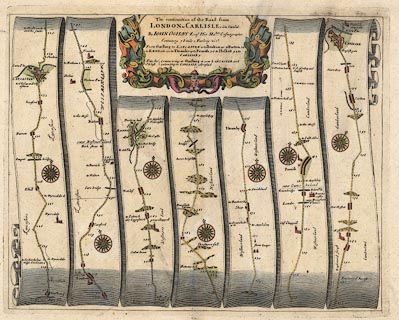 click to enlarge click to enlargeOG38.jpg "The continuation of the Road from LONDON to CARLISLE com~ Cumbr." item:- JandMN : 21 Image © see bottom of page |
|||||||||||||||||||||||||||||||||||||||||||||||||||||||||||||||||||||||||||||||||||||||||||||||
|
|
||||||||||||||||||||||||||||||||||||||||||||||||||||||||||||||||||||||||||||||||||||||||||||||||
| evidence:- | old map:- Berry 1679 |
|||||||||||||||||||||||||||||||||||||||||||||||||||||||||||||||||||||||||||||||||||||||||||||||
| source data:- | Road map, diagram, The Grand Roads of England, engraved by John
Rich, made and published by William Berry, at the Sign of the
Globe, London, 1679. from the south; through Lancaster Saturday 3 miles to Boulton 2 Carnford, Lancashire; 3 Burton Tuesday 6 Sigeswick 2 Kendal Saturday 11 Shap 2 Thrumby, Westmorland; then 5 Penrith Tuesday 3 Saucold-Yate 4 Hesket 5 Carlton 2 CARLILE Saturday |
|||||||||||||||||||||||||||||||||||||||||||||||||||||||||||||||||||||||||||||||||||||||||||||||
|
|
||||||||||||||||||||||||||||||||||||||||||||||||||||||||||||||||||||||||||||||||||||||||||||||||
| evidence:- | old map:- Morden 1695 (EW) |
|||||||||||||||||||||||||||||||||||||||||||||||||||||||||||||||||||||||||||||||||||||||||||||||
| source data:- | Map, hand coloured engraving, England, including Wales, scale
about 27 miles to 1 inch, by Robert Morden, published by Abel
Swale Awnsham and John Churchil, London, about 1695. click to enlarge click to enlargeMRD3Cm.jpg double line; road item:- JandMN : 339 Image © see bottom of page |
|||||||||||||||||||||||||||||||||||||||||||||||||||||||||||||||||||||||||||||||||||||||||||||||
|
|
||||||||||||||||||||||||||||||||||||||||||||||||||||||||||||||||||||||||||||||||||||||||||||||||
| evidence:- | old strip map:- Senex 1719 (plate 37/Roads) |
|||||||||||||||||||||||||||||||||||||||||||||||||||||||||||||||||||||||||||||||||||||||||||||||
| source data:- | Strip map, road map, part of The Road from London to Carlisle in Cumberland, with
the itinerary for the route from Darlaston Bridge to Carlisle, by John Senex, The
Globe, Salisbury Court, Fleet Street, London, 1719.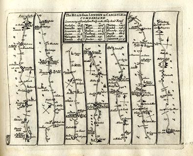 click to enlarge click to enlargeSEN5M1.jpg Plate 37, numbered 39, in An Actual Survey of all the Principal Roads of England and Wales. printed at title cartouche, upper centre:- "The ROAD from LONDON to CARLISLE in / CUMBERLAND / Commencing at Darlaston Bridg in the Holy-head Road / ... / Lancaster 233 / Boulton 237 / Burton 244½ / Kendal 256½ / Thrumby 275¾ / Penrith 282½ / Hesket 292 / CARLISLE 301¼" printed at bottom right:- "39" item:- private collection : 272.1 Image © see bottom of page |
|||||||||||||||||||||||||||||||||||||||||||||||||||||||||||||||||||||||||||||||||||||||||||||||
|
|
||||||||||||||||||||||||||||||||||||||||||||||||||||||||||||||||||||||||||||||||||||||||||||||||
| evidence:- | old strip map:- Senex 1719 (plate 38/Roads) |
|||||||||||||||||||||||||||||||||||||||||||||||||||||||||||||||||||||||||||||||||||||||||||||||
| source data:- | Strip map, road map, part of The Road from London to Carlisle in Cumberland, including
from Lancaster, Lancashire; through Burton, Kendal, Shap, Westmorland; then Penrith
to Carlisle, Cumberland, by John Senex, The Globe, Salisbury Court, Fleet Street,
London, 1719.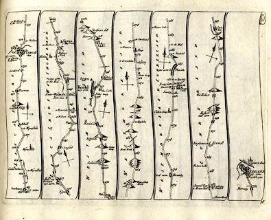 click to enlarge click to enlargeSEN5M2.jpg Plate 38 in An Actual Survey of all the Principal Roads of England and Wales. printed at bottom right:- "38" item:- private collection : 272.2 Image © see bottom of page |
|||||||||||||||||||||||||||||||||||||||||||||||||||||||||||||||||||||||||||||||||||||||||||||||
|
|
||||||||||||||||||||||||||||||||||||||||||||||||||||||||||||||||||||||||||||||||||||||||||||||||
| evidence:- | old map, descriptive text:- Bowen 1720 (plate 90) |
|||||||||||||||||||||||||||||||||||||||||||||||||||||||||||||||||||||||||||||||||||||||||||||||
| source data:- | Road book, Britannia Depicta Or Ogilby Improv'd, including road
strip maps with sections in Westmorland and Cumberland, scale
about 2 miles to 1 inch, derived from maps by Ogilby, 1675, also
a county map of Westmorland, scale about 8 miles to 1 inch, and
of Cumberland, scale about 16.5 miles to 1 inch, each with text,
by John Owen, published by Emanuel Bowen, London, 1720;
published 1720-64. Plate 90, which has the county map of Staffordshire, has the title cartouche for:- "THE ROAD FROM LONDON TO CARLISLE IN CUMBERLAND Com~encing at Darlaston-Bridge in the HOLY-HEAD ROAD see Page 55" and a table of distances, computed and measured miles in miles'furlongs from London, which includes:- "Lancaster 187 / 232'7" "Boulton 190 / 237" "Burton 195 / 244'4" "Kendal 203 / 256'5" "Thrumby 216 / 275'5" "Penrith 221 / 282'5" "Hesket 228 / 292" "CARLISLE 235 / 301'2" |
|||||||||||||||||||||||||||||||||||||||||||||||||||||||||||||||||||||||||||||||||||||||||||||||
|
|
||||||||||||||||||||||||||||||||||||||||||||||||||||||||||||||||||||||||||||||||||||||||||||||||
| evidence:- | old map:- Bowen 1720 (plate 94) |
|||||||||||||||||||||||||||||||||||||||||||||||||||||||||||||||||||||||||||||||||||||||||||||||
| source data:- | Strip maps, uncoloured engravings, road maps, The Road from
London to Carlisle, scale about 2 miles to 1 inch, with sections
in Lancashire and Westmorland, published by Emanuel Bowen, St
Katherines, London, 1720.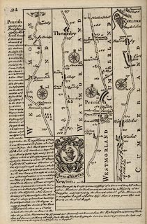 click to enlarge click to enlargeB094.jpg The Road from London to Carlisle - from just north of Kendal, to Carlisle, Cumberland. Places labelled are:- ... / 260 / Belome Hill / 262, Skelsmore Fell on right / ... / 263, Banesdale Horse / ... 265 / Horse House / a Bridge / ... / 270 / Stone heap on right / 271 / Green holm on left / 272 / Shap / 273 ... 275 / Thrumby / 276 ... 279 / 280, Clifton Chap on left / 281 / over Lowther Flu. / Broom Castle on right / Emon Br over Eden Flu / enter Cumberland / 282 / Penrith note the two vertical ?stones drawn by the church / 283 ... 287 Lasenby and [Saufell] / 288, Englewood Forrest on both sides, 292 / Hesket / 293 / Wa[r] Hesket / 294 ... 298 / Carlton / 299 / Burraby / 300 / CARLISLE, with town walls, castle and cathedral, entering by English Gate. Eden Flu. and Stanwick Chapel item:- Dove Cottage : 2007.38.100 Image © see bottom of page |
|||||||||||||||||||||||||||||||||||||||||||||||||||||||||||||||||||||||||||||||||||||||||||||||
|
|
||||||||||||||||||||||||||||||||||||||||||||||||||||||||||||||||||||||||||||||||||||||||||||||||
| evidence:- | old map, descriptive text:- Bowen 1720 (plate 93) |
|||||||||||||||||||||||||||||||||||||||||||||||||||||||||||||||||||||||||||||||||||||||||||||||
| source data:- | Strip maps, uncoloured engravings, road maps, The Road from
London to Carlisle, scale about 2 miles to 1 inch, with sections
in Lancashire and Westmorland, published by Emanuel Bowen, St
Katherines, London, 1720.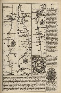 click to enlarge click to enlargeB093.jpg The Road from London to Carlisle - from Garstang, Lancashire to past Kendal, Westmorland. Places labelled are:- ... 243 / enter Westmorland / 244 / Burton / 245 / 246 / Holmes Park on east / Holme off to west / 247 / Holton Cragg / Farleton Knot / 248 ... 249 / Preston Chap. / Pesa Bridge / ... 251 / Sallatbrow / 252 / Grove Chap. on right / 253, Sedgwick / 254, Natland / 255 ... 256 / Nether Bridge, Kent Flu., the Castle, Kendal, Dockrey Hall / 257 ... item:- Dove Cottage : 2007.38.100 Image © see bottom of page |
|||||||||||||||||||||||||||||||||||||||||||||||||||||||||||||||||||||||||||||||||||||||||||||||
|
|
||||||||||||||||||||||||||||||||||||||||||||||||||||||||||||||||||||||||||||||||||||||||||||||||
| evidence:- | old map:- Millward and Dickinson 1737 |
|||||||||||||||||||||||||||||||||||||||||||||||||||||||||||||||||||||||||||||||||||||||||||||||
| source data:- | Road map, photocopy, diagram, A New and Correct Map of Roads of
England, probably published by T Millward and B Dickinson, Inigo
Jones's Head, Fleet Street, London, 1737. "Road to Carlisle" 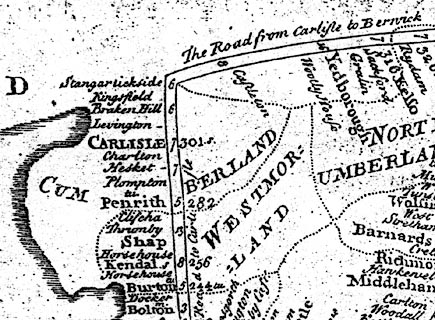 click to enlarge click to enlargeMWD1Cm.jpg item:- private collection : 264 Image © see bottom of page |
|||||||||||||||||||||||||||||||||||||||||||||||||||||||||||||||||||||||||||||||||||||||||||||||
|
|
||||||||||||||||||||||||||||||||||||||||||||||||||||||||||||||||||||||||||||||||||||||||||||||||
| evidence:- | old road book:- Morgan 1759 |
|||||||||||||||||||||||||||||||||||||||||||||||||||||||||||||||||||||||||||||||||||||||||||||||
| source data:- | MG01p065.txt page 65 "LONDON to Carlisle, and thence to Berwick." pages 68 and 69 item:- private collection : 368 Image © see bottom of page
Image © see bottom of page |
|||||||||||||||||||||||||||||||||||||||||||||||||||||||||||||||||||||||||||||||||||||||||||||||
|
|
||||||||||||||||||||||||||||||||||||||||||||||||||||||||||||||||||||||||||||||||||||||||||||||||
| evidence:- | old text:- Gents Mag item:- road map; Correct Map of the Road from London to Carlisle; Road from Carlisle to Berwick |
|||||||||||||||||||||||||||||||||||||||||||||||||||||||||||||||||||||||||||||||||||||||||||||||
| source data:- | Road strip map, uncoloured engraving, A Correct Map of the Road
from London to Carlisle and The Road from Carlisle to Berwick,
scale roughly 3.5 miles to 1 inch, by John Gibson, published in
the Gentleman's Magazine, London, 1765-66. goto source Gentleman's Magazine 1766 opp p.466 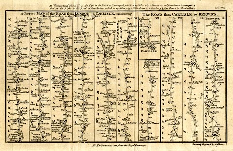 click to enlarge click to enlargeGB01.jpg Road strip map, uncoloured engraving, A Correct Map of the Road from London to Carlisle and The Road from Carlisle to Berwick, scale roughly 3.5 miles to 1 inch, by John Gibson, published by the Gentleman's Magazine, London, 1765-66. "A Correct MAP of the ROAD from LONDON to CARLISLE, commencing / at Darlaston Bridge, in the CHESTER ROAD." "..." "NB. The Distances are from the Royal Exchange." Size: wxh, sheet = 31x20cm; wxh, map = 286x172mm; scale: 1 to 240000? estimate. London to Carlisle - from Darlaston Bridge, Staffordshire; through Cheshire; to Lancaster, Lancashire; then Burton, Kendal, Shap, Westmorland; to Penrith and Carlisle, Cumberland. item:- Dove Cottage : 2007.38.3 Image © see bottom of page |
|||||||||||||||||||||||||||||||||||||||||||||||||||||||||||||||||||||||||||||||||||||||||||||||
|
|
||||||||||||||||||||||||||||||||||||||||||||||||||||||||||||||||||||||||||||||||||||||||||||||||
| evidence:- | old map:- Kitchin 1767 (plate 40) |
|||||||||||||||||||||||||||||||||||||||||||||||||||||||||||||||||||||||||||||||||||||||||||||||
| source data:- | Road strip map, uncoloured engraving, The Road from London to
Carlisle, in Kitchin's Post Chaise Companion, by Thomas Kitchin,
published by Robert Sayer, 53 Fleet Street, John Bowles,
Cornhill, and Carington Bowles, St Paul's Church Yard, London,
1767.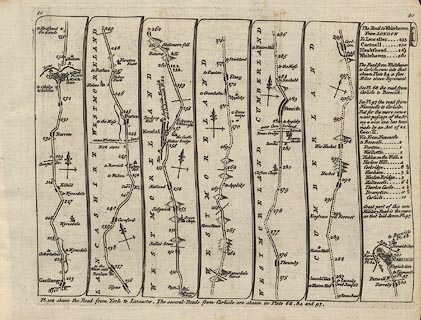 click to enlarge click to enlargeK040.jpg item:- Hampshire Museums : FA1999.138.40 Image © see bottom of page |
|||||||||||||||||||||||||||||||||||||||||||||||||||||||||||||||||||||||||||||||||||||||||||||||
|
|
||||||||||||||||||||||||||||||||||||||||||||||||||||||||||||||||||||||||||||||||||||||||||||||||
| evidence:- | old strip map:- Jeffery 1775 (pl.38/Roads) |
|||||||||||||||||||||||||||||||||||||||||||||||||||||||||||||||||||||||||||||||||||||||||||||||
| source data:- | Strip map, road map, part of From London to Carlisle, with the itinerary of the whole
route, by Thomas Jefferys, published by R Sayer and J Bennett, 53 Fleet Street, London,
1775.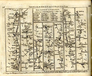 click to enlarge click to enlargeJEF6M2.jpg Plate 38 in Jefferys's Itinerary or Travellers Companion. printed at plain cartouche, upper centre:- "From LONDON to CARLISLE, / commencing at Darlaston Bridge, see plate 23. / Darlaston Br. 141 / Newcastle 149 / Brewerston 163 / Grulam 172 / Warrington 182 / Wigan 195 / Preston 212 / Garstang 223 / Lancaster 233 / Burton 245 / Kendal 257 / Shap 273 / Penrith 283 / Hesketh 292 / Carlisle 301" printed at top:- "38 / Publish'd as the Acts directs by R. Sayer &I. Bennett 16 Janry. 1775. / 38" item:- private collection : 271.2 Image © see bottom of page |
|||||||||||||||||||||||||||||||||||||||||||||||||||||||||||||||||||||||||||||||||||||||||||||||
|
|
||||||||||||||||||||||||||||||||||||||||||||||||||||||||||||||||||||||||||||||||||||||||||||||||
| evidence:- | old strip map:- Jeffery 1775 (pl.39/Roads) |
|||||||||||||||||||||||||||||||||||||||||||||||||||||||||||||||||||||||||||||||||||||||||||||||
| source data:- | Strip map, road map, part of From London to Carlisle, from Garstang through Lancaster,
Lancashire; then Burton-in-Kendal, Kendal, Shap, Westmorland; Penrith to Carlisle;
and an itinerary from Lancaster to Whitehaven, by Thomas Jefferys, published by R
Sayer and J Bennett, 53 Fleet Street, London, 1775. click to enlarge click to enlargeJEF6M3.jpg Plate 39 in Jefferys's Itinerary or Travellers Companion. printed at top left and right:- "39 / 39" printed at bottom right of centre:- "Publish'd as the Acts directs by R. Sayer &I. Bennett 16 Janry. 1775." item:- private collection : 271.3 Image © see bottom of page |
|||||||||||||||||||||||||||||||||||||||||||||||||||||||||||||||||||||||||||||||||||||||||||||||
|
|
||||||||||||||||||||||||||||||||||||||||||||||||||||||||||||||||||||||||||||||||||||||||||||||||
| evidence:- | old strip map:- Smith 1826 (Roads/Cum) |
|||||||||||||||||||||||||||||||||||||||||||||||||||||||||||||||||||||||||||||||||||||||||||||||
| source data:- | Strip map, pp.76-78, including To Manchester continued to Lancaster, Kendal and Penrith,
published by Charles Smith and Son, 172 Strand, London, 1st edn 1826. click to enlarge click to enlargeSM22M2.jpg from Lancaster, Lancashire; through Burton-in-Kendal, Kendal, Shap, Westmorland; to Penrith, Cumberland; and other routes. Included in Smith's Pocket New Companion to the Roads of England and Wales. printed at p.74:- "TO MANCHESTER / continued to Lancaster / Kendal and Penrith" item:- private collection : 269.2 Image © see bottom of page |
|||||||||||||||||||||||||||||||||||||||||||||||||||||||||||||||||||||||||||||||||||||||||||||||
|
|
||||||||||||||||||||||||||||||||||||||||||||||||||||||||||||||||||||||||||||||||||||||||||||||||
| evidence:- | old strip map:- Smith 1826 (Roads/Cum) |
|||||||||||||||||||||||||||||||||||||||||||||||||||||||||||||||||||||||||||||||||||||||||||||||
| source data:- | Strip map, pp.100-102, including To Edinburgh by Carlisle and Longtown, published
by Charles Smith and Son, 172 Strand, London, 1st edn 1826.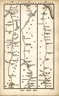 click to enlarge click to enlargeSM22M6.jpg From Rey Cross; through Brough and Appleby, Westmorland; then Penrith, Carlisle, Longtown, Cumberland; into Scotland; and other routes. Included in Smith's Pocket New Companion to the Roads of England and Wales. printed at p.90:- "TO EDINBURGH / by Carlisle and / LONGTOWN" item:- private collection : 269.6 Image © see bottom of page |
|||||||||||||||||||||||||||||||||||||||||||||||||||||||||||||||||||||||||||||||||||||||||||||||
|
|
||||||||||||||||||||||||||||||||||||||||||||||||||||||||||||||||||||||||||||||||||||||||||||||||
| evidence:- | gradient diagram:- Pratt 1905 (edn 1915) |
|||||||||||||||||||||||||||||||||||||||||||||||||||||||||||||||||||||||||||||||||||||||||||||||
| source data:- | Gradient diagram, Liverpool to Carlisle, in Pratt's Road Atlas of England and Wales
... by George Philip and Son, 32 Fleet Street, London, 1905, published by Anglo-American
Oil Co, 36-38 Queen Anne's Gate, Westminster, London, 1915.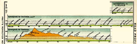 click to enlarge click to enlargePRA1G1.jpg "LIVERPOOL to CARLISLE" item:- Hampshire Museums : FA2001.138 Image © see bottom of page |
|||||||||||||||||||||||||||||||||||||||||||||||||||||||||||||||||||||||||||||||||||||||||||||||
|
|
||||||||||||||||||||||||||||||||||||||||||||||||||||||||||||||||||||||||||||||||||||||||||||||||
| evidence:- | old text:- Harper 1907 item:- mail coach; stage coach |
|||||||||||||||||||||||||||||||||||||||||||||||||||||||||||||||||||||||||||||||||||||||||||||||
| source data:- | Guidebook, The Manchester and Glasgow Road, by Charles G Harper,
published by Chapman and Hall Ltd, London, 1907. HP01p146.txt Page 146:- "..." "THE greatest figure in the coaching world up north was Teather, who was principal contractor for mails and stage coaches in all that lengthy territory of 166 miles between Lancaster and Glasgow. The careers of the Teathers reflect the fortunes of the road. John Teather, the father, was originally landlord of the "Royal Oak," Keswick, which does not stand on the main route to the north; but he left the comparative obscurity of that Lakeland town for the bustling activities of Carlisle, and from that strategic coaching position worked the coaches sixty-five miles south to Lancaster, and 101 miles north, to Glasgow." "Eight mails entered and left Carlisle daily, and seven stage-coaches; and eighty horses were kept for the proper working of them. Teather and his son managed this important business: the younger succeeding to it in 1837 and, in the general wreck brought about by railway extension, living to end where his father had begun, as landlord of the "Royal Oak" at Keswick." "..." "It was in December, 1846, that the first railway ran into Carlisle from the south. It was the Lancaster and Carlisle" HP01p147.txt Page 147:- "Railway, long since absorbed into the London and North-Western. ... It was necessarily the death-blow of the coaches along the main route. ..." |
|||||||||||||||||||||||||||||||||||||||||||||||||||||||||||||||||||||||||||||||||||||||||||||||
|
|
||||||||||||||||||||||||||||||||||||||||||||||||||||||||||||||||||||||||||||||||||||||||||||||||
| evidence:- | old itinerary:- Johnson 1908 (Roads/Cum) |
|||||||||||||||||||||||||||||||||||||||||||||||||||||||||||||||||||||||||||||||||||||||||||||||
| source data:- | Itinerary, Route 37 in Roads Made Easy by Picture and Pen, Preston to Glasgow, by
Claude Johnson, edited by Lord Montagu, published by The Car Illustrated, 168 Piccadilly,
London, 1908.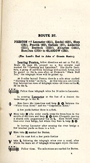 click to enlarge click to enlargeJS5001.jpg pp.1-10 in the road book, Roads Made Easy by Picture and Pen, vol.3. printed at beginning, p.1:- "ROUTE 37. / PRESTON via Lancaster (21½), Kendal (42½), Shap (58½), Penrith (69), Carlisle (87), Lockerbie (111½), Beattock (125¾), Abington (144½), Hamilton (170½) to GLASGOW (182). / (The Land's End to John o' Groats Route.)" 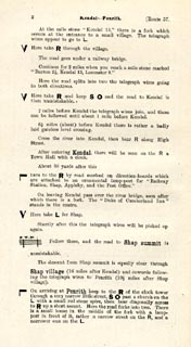 click to enlarge click to enlargeJS5002.jpg  click to enlarge click to enlargeJS5003.jpg  click to enlarge click to enlargeJS5004.jpg  click to enlarge click to enlargeJS5005.jpg item:- private collection : 268.2 Image © see bottom of page |
|||||||||||||||||||||||||||||||||||||||||||||||||||||||||||||||||||||||||||||||||||||||||||||||
|
|
||||||||||||||||||||||||||||||||||||||||||||||||||||||||||||||||||||||||||||||||||||||||||||||||
| evidence:- | old itinerary:- Johnson 1908 (Roads/Cum) |
|||||||||||||||||||||||||||||||||||||||||||||||||||||||||||||||||||||||||||||||||||||||||||||||
| source data:- | Itinerary, Route 37 reverse in Roads Made Easy by Picture and Pen, Glasgow to Preston,
by Claude Johnson, edited by Lord Montagu, published by The Car Illustrated, 168 Piccadilly,
London, 1908. click to enlarge click to enlargeJS5015.jpg pp.11-21 in the road book, Roads Made Easy by Picture and Pen, vol.3. printed at beginning, p.11:- "ROUTE 37. Reverse / GLASGOW via Hamilton (11½), Abington (37½), Beattock (56¼), Lockerbie (70½), Carlisle (95), Penrith (113), Shap (123½), Kendal (139½), Lancaster (160½) to PRESTON (182)."  click to enlarge click to enlargeJS5016.jpg  click to enlarge click to enlargeJS5017.jpg  click to enlarge click to enlargeJS5018.jpg  click to enlarge click to enlargeJS5019.jpg item:- private collection : 268.3 Image © see bottom of page |
|||||||||||||||||||||||||||||||||||||||||||||||||||||||||||||||||||||||||||||||||||||||||||||||
|
|
||||||||||||||||||||||||||||||||||||||||||||||||||||||||||||||||||||||||||||||||||||||||||||||||
| evidence:- | old itinerary:- Johnson 1908 (Roads/Cum) |
|||||||||||||||||||||||||||||||||||||||||||||||||||||||||||||||||||||||||||||||||||||||||||||||
| source data:- | Itinerary, Route 37a in Roads Made Easy by Picture and Pen, Penrith to Carlisle alternative
route, by Claude Johnson, edited by Lord Montagu, published by The Car Illustrated,
168 Piccadilly, London, 1908.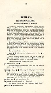 click to enlarge click to enlargeJS5022.jpg pp.22-23 in the road book, Roads Made Easy by Picture and Pen, vol.3. printed at beginning, p.22:- "ROUTE 37A. / PENRITH to CARLISLE. / An Alternative Route by By-roads." 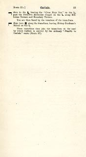 click to enlarge click to enlargeJS5023.jpg item:- private collection : 268.4 Image © see bottom of page |
|||||||||||||||||||||||||||||||||||||||||||||||||||||||||||||||||||||||||||||||||||||||||||||||
|
|
||||||||||||||||||||||||||||||||||||||||||||||||||||||||||||||||||||||||||||||||||||||||||||||||
| evidence:- | old itinerary:- Johnson 1908 (Roads/Cum) |
|||||||||||||||||||||||||||||||||||||||||||||||||||||||||||||||||||||||||||||||||||||||||||||||
| source data:- | Itinerary, Route 37a reverse in Roads Made Easy by Picture and Pen, Penrith to Carlisle
alternative route, by Claude Johnson, edited by Lord Montagu, published by The Car
Illustrated, 168 Piccadilly, London, 1908.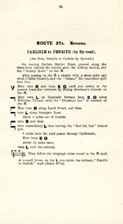 click to enlarge click to enlargeJS5024.jpg p.24 in the road book, Roads Made Easy by Picture and Pen, vol.3. printed at beginning, p.24:- "ROUTE 37A. Reverse / CARLISLE to PENRITH (by By-road)." item:- private collection : 268.5 Image © see bottom of page |
|||||||||||||||||||||||||||||||||||||||||||||||||||||||||||||||||||||||||||||||||||||||||||||||
|
|
||||||||||||||||||||||||||||||||||||||||||||||||||||||||||||||||||||||||||||||||||||||||||||||||
| evidence:- | old strip map:- Geographia 1925 |
|||||||||||||||||||||||||||||||||||||||||||||||||||||||||||||||||||||||||||||||||||||||||||||||
| source data:- | Road book, with road strip maps and gradient diagrams, Premier Road Book of Great
Britain, by Alexander Gross and F Waite-Browne, published by Geographia, 55 Fleet
Street, London, about 1925?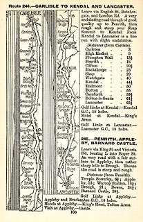 click to enlarge click to enlargeGE1100.jpg "Route 244. - CARLISLE TO PENRITH AND LANCASTER." item:- Hampshire Museums : B1990.161.4 Image © see bottom of page |
|||||||||||||||||||||||||||||||||||||||||||||||||||||||||||||||||||||||||||||||||||||||||||||||
|
|
||||||||||||||||||||||||||||||||||||||||||||||||||||||||||||||||||||||||||||||||||||||||||||||||
| notes:- |
Referring to an early meeting of the turnpike trust:- |
|||||||||||||||||||||||||||||||||||||||||||||||||||||||||||||||||||||||||||||||||||||||||||||||
| "It is an Observation confirmed by the Experience of all wise Men in all Ages, that nothing is so detrimental and obnoxious to the Prosperity and Wellbeing of a Government, as the particular Jealousies and Quarrels of its Subjects ... A melancholy instance of this manifestly appears from the vigourous Opposition, that the Scheme for a Turnpike thro' the County of Westmorland has met with since it was first proposed. A Scheme calculated solely to preserve and increase the Trade and Prosperity of the County, as well as for the Ease and Advantage of every Individual. At the first Meeting, about this Time two Years, all the Company except two or three seemed desirous of promoting so useful and necessary a Work. The Persons who then opposed it, did not concern themselves for the Bulk of the People, or in the least consider the true Interest of the County, but stuck wholly to their own Emolument. ... The wrong and absurd Scheme which they urged in Opposition proved how improper they were to be consulted in Undertakings of that Kind. ... It gives me great Pleasure to hear that the Spirit which shone forth at the Beginning of this Affair, and was so long unfortunately suppressed and obscured has again blazed out with superior Strength and Lustre. The subscription opened by the Gentlemen of Kendal and signed by many others from different Parts is an Example worthy of the highest Commendation. The particular Necessity there is for the Roads being mended in Westmorland wants no Demonstration to those that have ever travelled a few Miles in any Part of the County. ... I believe it is universally allowed by all Parties that the Roads are excessively bad, and even in some places dangerous to be passed. ..." |
||||||||||||||||||||||||||||||||||||||||||||||||||||||||||||||||||||||||||||||||||||||||||||||||
| : 1749:: Agreeable Miscellany |
||||||||||||||||||||||||||||||||||||||||||||||||||||||||||||||||||||||||||||||||||||||||||||||||
|
|
||||||||||||||||||||||||||||||||||||||||||||||||||||||||||||||||||||||||||||||||||||||||||||||||
Lakes Guides menu.