 Gents Mag 1766 opp p.466

|

|
|
|

|
introduction | ||
|
|
list, 3rd qtr 18th century | ||
|
Gentleman's Magazine 1766 opp p.466
|
|||
|
road map road, London to Carlisle road, Carlisle to Berwick |
|||
Roads to Carlisle
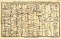 Road strip map, uncoloured engraving, A Correct Map of the Road from London to Carlisle and The Road from Carlisle to Berwick, scale roughly 3.5 miles to 1 inch, by John Gibson, published by the Gentleman's Magazine, London, 1765-66. A Correct MAP of the ROAD from LONDON to CARLISLE, commencing / at Darlaston Bridge, in the CHESTER ROAD. The ROAD from CARLISLE to BERWICK. NB. The Distances are from the Royal Exchange. map type: Gibson 1766 Size: wxh, sheet = 31x20cm; wxh, map = 286x172mm; scale: 1 to 240000? estimate. London to Carlisle - from Darlaston Bridge, Staffordshire; through Cheshire; to Lancaster, Lancashire; then Burton, Kendal, Shap, Westmorland; to Penrith and Carlisle, Cumberland. Carlisle to Berwick - from Carlisle, Cumberland; across Kershope Burn near Kirkby Hill, and through Jedburgh, Kelso, Scotland; to Berwick, Northumberland. |
|||
|
gazetteer links
|
|||
|
|
-- Carlisle to Berwick | ||
|
|
-- Lancaster to Carlisle | ||
|
|
|||
Lakes Guides menu.