 |
 |
|
|
|
|
|
|
|
Upper Allithwaite |
|
|
| county:- |
Cumbria |
| old county:- |
Lancashire |
| locality type:- |
parish |
| 1Km square:- |
SD4183 |
| 10Km square:- |
SD38 |
| 10Km square:- |
SD48 |
| 10Km square:- |
SD47 |
| references:- |
OS 1974 Admin Areas
|
|
|
| evidence:- |
old map:- Cooke 1802
placename:- Upper Allithwaite
|
| source data:- |
Map, Lancashire, scale about 18 miles to 1 inch, by George
Cooke, 1802, bound in Gray's New Book of Roads, 1824, published
by Sherwood, Jones and Co, Paternoster Road, London, 1824.
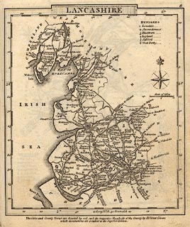 click to enlarge click to enlarge
GRA1La.jpg
"Uppr. A[l]lithwaite"
blocks, italic lowercase text, village, hamlet, locality
item:- Hampshire Museums : FA2000.62.6
Image © see bottom of page
|
|
|
| evidence:- |
census:- Census 1971
|
|
Population: 698 (1971) |
|
|
| places:- |
 |
SD40578221 barn, Low Newton |
|
|
|
SD41548504 barn, Upper Allithwaite |
|
|
|
SD40698484 Barrow Hollin, Height |
|
|
|
SD40688483 Barrow Hollin, Upper Allithwaite L |
|
|
|
SD41628019 Brocka, Upper Allithwaite |
|
|
|
SD40978184 Buck Crag, Upper Allithwaite |
|
|
|
SD413807 Burnbank Farm, Upper Allithwaite |
|
|
|
SD41588053 Coronation Tree, Lindale |
|
|
|
SD40228294 Crown Inn, High Newton |
|
|
|
SD40128285 drain, High Newton |
|
|
|
SD41528037 drain, Lindale |
|
|
|
SD40558218 East View, Low Newton L |
|
|
|
SD411813 Eller How, Upper Allithwaite |
|
|
|
SD41338078 footbridge, Lindale |
|
|
|
SD40088284 Greensyke, High Newton L |
|
|
|
SD407853 Hare Hill, Upper Allithwaite |
|
|
|
SD397822 Head House, Upper Allithwaite |
|
|
|
SD403845 Height, Upper Allithwaite |
|
|
|
SD41948491 Helton Tarn, Upper Allithwaite |
|
|
|
SD40038283 High Newton, Upper Allithwaite |
|
|
|
SD415856 High Tarn Green, Upper Allithwaite |
|
|
|
SD40108302 Hill Top, High Newton |
|
|
|
SD419838 Holme, Upper Allithwaite |
|
|
|
SD40068284 house, High Newton |
|
|
|
SD41608055 house, Lindale gone |
|
|
|
SD42578093 Jack Crag Barn, Upper Allithwaite |
|
|
|
SD40128200 limekiln, Upper Allithwaite L |
|
|
|
SD39848190 limekiln, Upper Allithwaite (2) |
|
|
|
SD41678054 Lindale Stores, Lindale |
|
|
|
SD41618054 Lindale, Upper Allithwaite |
|
|
|
SD415805 Lindale, Upper Allithwaite: Sears Bespoke Joinery |
|
|
|
SD42368241 Low Green, Upper Allithwaite L |
|
|
|
SD40558222 Low Newton Farm, Low Newton |
|
|
|
SD40578221 Low Newton, Upper Allithwaite |
|
|
|
SD41618510 Low Tarn Green, Upper Allithwaite |
|
|
|
SD40118293 Lowthers, High Newton |
|
|
|
SD43038117 Meathop Bridge, Meathop and Ulpha gone |
|
|
|
SD43068124 Meathop New Bridge, Meathop and Ulpha |
|
|
|
SD38477936 milestone, Broughton East (2) |
|
|
|
SD43098114 milestone, Upper Allithwaite gone |
|
|
|
SD40828142 milestone, Upper Allithwaite (2) |
|
|
|
SD41508048 mill pond, Lindale |
|
|
|
SD41138249 Newton Fell, Upper Allithwaite |
|
|
|
SD40108282 Newton Hall Cottage, High Newton L |
|
|
|
SD40098282 Newton Hall, High Newton L |
|
|
|
SD40138286 Newton House, High Newton |
|
|
|
SD40138294 Newton in Cartmel Village Hall, High Newton |
|
|
|
SD40848262 Newton Tarn, Upper Allithwaite |
|
|
|
SD40588214 Oakbank Barn, Low Newton |
|
|
|
SD40298284 pillbox, High Newton |
|
|
|
SD419801 pillbox, Lindale |
|
|
|
SD404832 pillbox, Newton Fell |
|
|
|
SD408833 pillbox, Upper Allithwaite |
|
|
|
SD420805 pillbox, Upper Allithwaite (2) |
|
|
|
SD425810 pillbox, Upper Allithwaite (3) |
|
|
|
SD427812 pillbox, Upper Allithwaite (4) |
|
|
|
SD405822 post box, Upper Allithwaite |
|
|
|
SD40048288 pump, High Newton |
|
|
|
SD40678472 quaker burial ground, Height |
|
|
|
SD408837 race course, Upper Allithwaite |
|
|
|
SD41318062 Royal Oak, Lindale |
|
|
|
SD41578039 school, Lindale |
|
|
|
SD4085 Silver Birch, Upper Allithwaite |
|
|
|
SD41318078 Skinner Hill, Lindale L |
|
|
|
SD41958208 Sunny Green, Upper Allithwaite |
|
|
|
SD412832 Tow Top Plantation, Upper Allithwaite |
|
|
|
SD41688054 Underfell, Lindale |
|
|
|
SD41598094 village hall, Lindale |
|
|
|
SD41398048 war memorial, Lindale |
|
|
|
SD41698052 water trough, Lindale |
|
|
|
SD41848032 Wilkinson Memorial, Lindale L |
|
|
|
SD42568090 Wilson House Bridge, Meathop and Ulpha L |
|
|
|
SD42608092 Wilson House, Upper Allithwaite |
|
|
|
SD42258376 Bleacrag Bridge, Witherslack L |
|
|
|
SD4285 Winster, River |
|
|
|
SD42808114 Wilson House Turnpike, Upper Allithwaite gone |
|
|
|
SD40348280 milestone, Upper Allithwaite (3) |
|
|
|
SD41948040 milestone, Upper Allithwaite (4) |
|
|
|
SD40688482 meeting house, Height L |
|
|
|
SD41428040 St Paul, Lindale L |
|
