 Old Cumbria Gazetteer
 |
 |
|
| meeting house, Height | ||
| Barrow Wife | ||
| Height Meeting House | ||
| Cartmel Height Meeting House | ||
| High Newton Meeting House | ||
| Newton Fell meeting house | ||
| locality:- | Height | |
| locality:- | Newton Fell | |
| civil parish:- | Upper Allithwaite (formerly Lancashire) | |
| county:- | Cumbria | |
| locality type:- | buildings | |
| locality type:- | meeting house (ex) | |
| locality type:- | quaker meeting (ex) | |
| coordinates:- | SD40688482 | |
| 1Km square:- | SD4084 | |
| 10Km square:- | SD48 | |
| references:- | Butler 1978 |
|
|
|
||
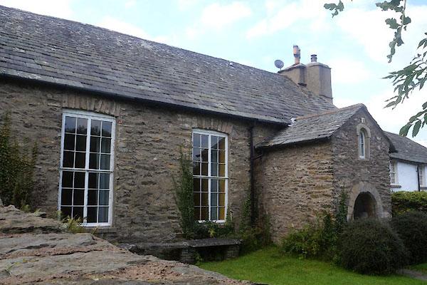 CDX62.jpg (taken 11.9.2015) 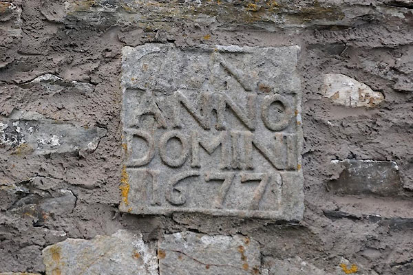 CDX64.jpg Date stone:- "[L N] / ANNO / DOMINI / 1677" (taken 11.9.2015) |
||
|
|
||
| evidence:- | old map:- OS County Series (Lan 12) placename:- Height Meeting House |
|
| source data:- | Maps, County Series maps of Great Britain, scales 6 and 25
inches to 1 mile, published by the Ordnance Survey, Southampton,
Hampshire, from about 1863 to 1948. "Height Meeting House (Quakers)" there is a Grave Yard down the road at SD40678471 |
|
|
|
||
| evidence:- | text:- placename:- Height Meeting House placename:- High Newton Meeting House |
|
| source data:- | : : Quaker Administrative History "HEIGHT, Lancs, after 1974 Cumbr ... SD407848" "1668-c1890 ... Swarthmore MM" "HIGH NEWTON, Lancs, after 1974 Cumbr ... see HEIGHT" "Removed to CARTMEL, qv" |
|
|
|
||
| evidence:- | old map:- Backhouse 1773 placename:- Height meeting |
|
| source data:- | Map, hand coloured engraving, Map of the Meetings belonging to
the Quarterly Meetings of Lancaster, Westmorland, Cumberland,
Northumberland, Durham and York, scale about 9 miles to 1 inch,
by James Backhouse, engraved by Thomas Kitchin, published by
James Backhouse, Darlington, Durham, 1773.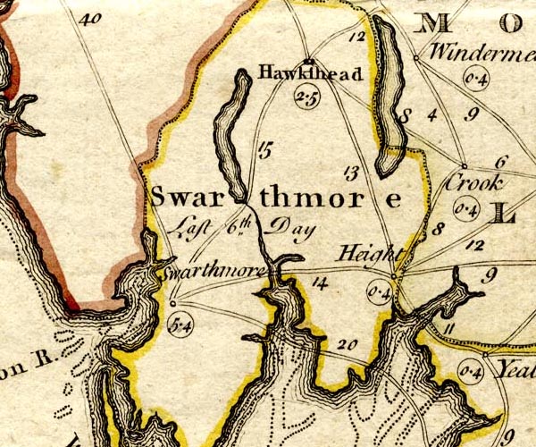 BKH2Swrt.jpg labelled:- "Height / 0.4" meeting day Wednesday item:- private collection : 224 Image © see bottom of page |
|
|
|
||
| evidence:- | drawing:- Butler 1978 placename:- Height Meeting House |
|
| source data:- | Height Meeting House drawn by David Butler and published in Quaker Meeting Houses
of the Lake Counties by David M Butler, by the Friends Historical Society, 1978 courtesy of David Butler 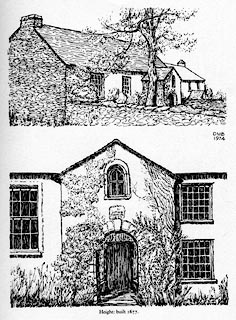 click to enlarge click to enlargePR1539.jpg 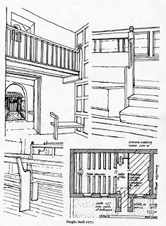 click to enlarge click to enlargePR1540.jpg item:- private collection : 377 Images © Friends Historical Society |
|
|
|
||
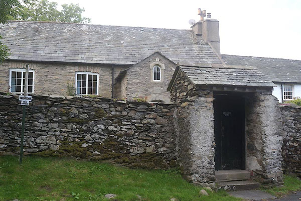
| evidence:- | database:- Listed Buildings 2010 placename:- Barrow Wife item:- date stone (1677) |
|
| source data:- | courtesy of English Heritage "BARROW WIFE / / HEIGHT ROAD / UPPER ALLITHWAITE / SOUTH LAKELAND / CUMBRIA / II[star] / 422221 / SD4068284824" |
|
|
|
||
| evidence:- | database:- Listed Buildings 2010 |
|
| source data:- | courtesy of English Heritage "FRIEND'S BURIAL GROUND WALLS / / HEIGHT ROAD / UPPER ALLITHWAITE / SOUTH LAKELAND / CUMBRIA / II / 422222 / SD4066984722" |
|
| source data:- | courtesy of English Heritage "Graveyard walls. c.1676. Stone rubble. Walls enclosing semi-circular area; wall to road approx. 45m; enclosure approx. 27m across at its widest. Entrance to south end has wide door in porch with gabled roof, the lintel inscribed: "FRIENDS BURIAL GROUND HEIGHT FIRST USED c.1676"." |
|
|
|
||
 CDX63.jpg (taken 11.9.2015) |
||
|
|
||
| hearsay:- |
Now a cottage, the building was a quaker meeting house in 1677 before the Act of Toleration
1689. It closed 1920. |
|
|
|
||
 Lakes Guides menu.