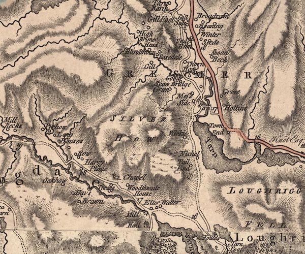
 Jefferys 1770 NY30NW

|

|
|
|
gazetteer links places may or may not be labelled on the map |
||

|
-- Above Beck -- "Aboon Beck" |
|
|
|
-- Baysbrown -- "Bays Brown" |
|
|
|
-- Blindtarn Gill Farm -- "Gill" |
|
|
|
-- Blindthorn -- "Blindthorn" |
|
|
|
-- bridge, Great Langdale |
|
|
|
-- bridge, Lakes |
|
|
|
-- Brimmer Head Farm -- "High Brimer Head" |
|
|
|
-- Church Bridge |
|
|
|
-- Dale End -- "Tail End" |
|
|
|
-- Dunney Beck |
|
|
|
-- Easedale Beck |
|
|
|
-- Easedale -- "Easedale" |
|
|
|
-- Elterwater Bridge |
|
|
|
-- Elterwater Hall -- "Hall" |
|
|
|
-- Elterwater -- "Elter Watter" |
|
|
|
-- Forest Side -- "Grove" |
|
|
|
-- Goody Bridge -- "Goody Bridge" |
|
|
|
-- Goody Bridge -- "Goody Bridge" |
|
|
|
-- Grasmere -- "Tarn" |
|
|
|
-- Grasmere -- "GRESMER" |
|
|
|
-- Great Langdale Beck |
|
|
|
-- Harry Place Farm -- "Harry Place" |
|
|
|
-- High Scorecrag Farm -- "Scow Green" |
|
|
|
-- Hollens, The -- "Hollins" |
|
|
|
-- Holy Trinity Church -- "Chapel" |
|
|
|
-- Lingmoor Fell |
|
|
|
-- Long House -- "Long Houses" |
|
|
|
-- Low Broadrain -- "Braning" |
|
|
|
-- Low Scorecrag -- "Scow Green" |
|
|
|
-- Elterwater Mill (?) -- "Mill" |
|
|
|
-- Moss Side -- "Moss Side" |
|
|
|
-- New Bridge |
|
|
|
-- Nichol -- "Nichol" |
|
|
|
-- Oak Howe -- "Oakhow" |
|
|
|
-- Raw Head -- "Row" |
|
|
|
-- Ambleside to Keswick -- "From White Haven and
Cockermouth" |
|
|
|
-- Langdale Valleys road |
|
|
|
-- Rothay, River |
|
|
|
-- Silver Howe -- "SILVER HOW" |
|
|
|
-- St Oswald's Church |
|
|
|
-- Thorney How -- "Thorn How" |
|
|
|
-- Thrang Farm -- "Thrang" |
|
|
|
-- Thrang, The -- "Thrang" |
|
|
|
-- Tongue Gill |
|
|
|
-- Town End -- "Town End" |
|
|
|
-- Underhelm Farm -- "Under Helm" |
|
|
|
-- Walthwaite -- "Woodthwaite House" |
|
|
|
-- White Bridge |
|
|
|
-- Winterseeds -- "Winter Seeds" |
|
|
|
-- Wyke, The -- "Wickie" |
|
|
civil parishes The area roughly includes parts of parishes:- Lakes |
||
|
|
||
|
|
Lakes Guides menu. | |