 Old Cumbria Gazetteer
 |
 |
|
||||||||||||||||||
| road, Langdale Valleys | ||||||||||||||||||||
| Langdale Valleys road | ||||||||||||||||||||
| civil parish:- | Lakes (formerly Westmorland) | |||||||||||||||||||
| county:- | Cumbria | |||||||||||||||||||
| locality type:- | route | |||||||||||||||||||
| 10Km square:- | NY30 | |||||||||||||||||||
| 10Km square:- | NY20 | |||||||||||||||||||
|
|
||||||||||||||||||||
| evidence:- | old map:- Jefferys 1770 (Wmd) |
|||||||||||||||||||
| source data:- | Map, 4 sheets, The County of Westmoreland, scale 1 inch to 1
mile, surveyed 1768, and engraved and published by Thomas
Jefferys, London, 1770.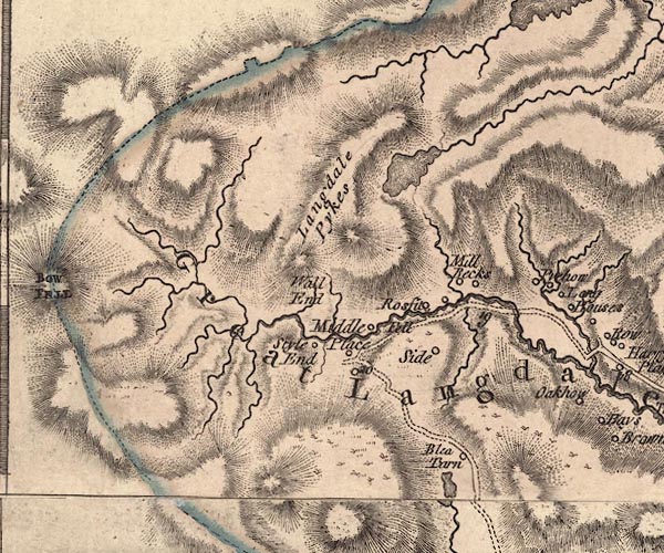 J5NY20NE.jpg 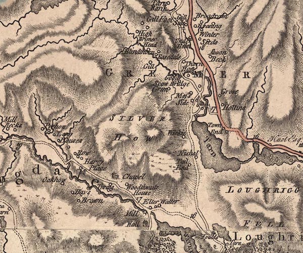 J5NY30NW.jpg 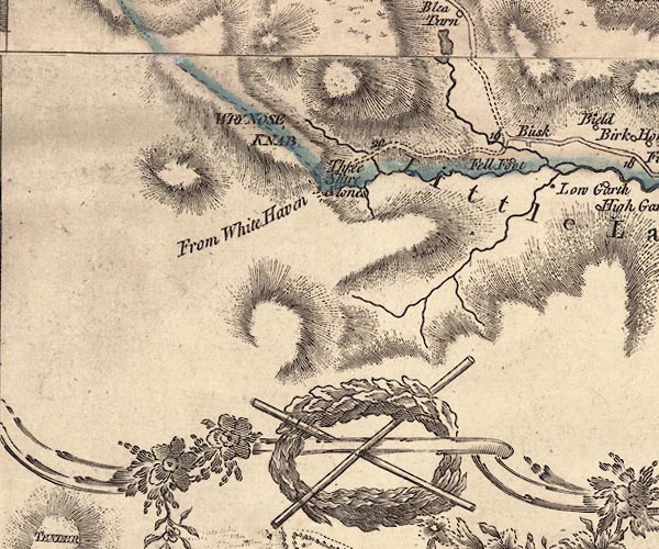 J5NY20SE.jpg 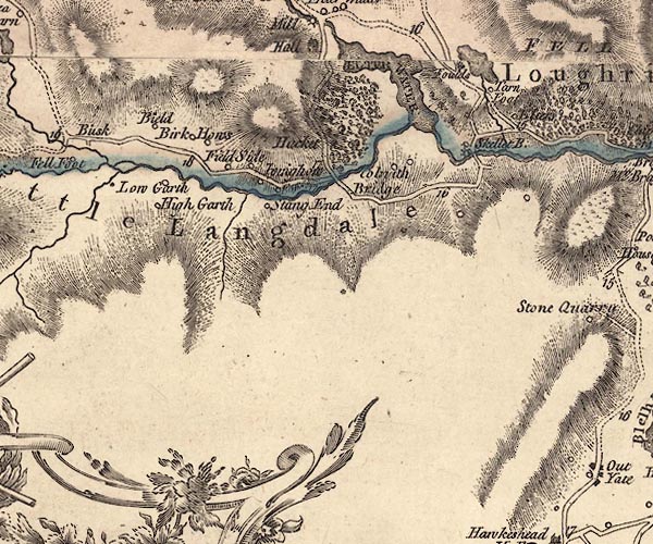 J5NY30SW.jpg double line; road, with mile numbers item:- National Library of Scotland : EME.s.47 Images © National Library of Scotland |
|||||||||||||||||||
|
|
||||||||||||||||||||
| evidence:- | old text:- Green 1814 |
|||||||||||||||||||
| source data:- | Set of prints, soft ground etchings, Sixty Small Prints, with
text, A Description of a Series of Sixty Small Prints, by
William Green, Ambleside, Westmorland, 1814. goto source goto sourcepage 9:- "..." "Pass Skelwith Bridge into Lancashire, and over high and pleasant ground to Colwith Bridge, which cross, and enter again into Westmorland, a little beyond which, on the left is Colwith Force. Little Langdale Tarn is about a mile and a half from Colwith Bridge, and five miles from Ambleside. This lake divides Lancashire and Westmorland; and the view, being taken from the latter county, is of the Coniston and Seathwaite mountains, which are in Lancashire." "..." "From Little Langdale Tarn proceed to within about a quarter of a mile of Fell Foot, and ascend the road on the right to the gate at the top of the hill; turn on the left diagonally towards the lake to the place from which this view [plate 13] is taken: the road connecting the two vallies is here observable; and the Langdale Pikes, as seen from this place, are sublime objects. - Blea Tarn is about eight miles from Ambleside." goto sourcepage 10:- "..." "From Blea Tarn by the farm-house called Wall End, it is about four miles to Oak How; but to Oak How by Langdale Chapel is about six miles, making the Langdale tour about eighteen miles." |
|||||||||||||||||||
|
|
||||||||||||||||||||
| evidence:- | descriptive text:- Otley 1823 (5th edn 1834) item:- itinerary; road distances |
|||||||||||||||||||
| source data:- | Guide book, A Concise Description of the English Lakes, the
mountains in their vicinity, and the roads by which they may be
visited, with remarks on the mineralogy and geology of the
district, by Jonathan Otley, published by the author, Keswick,
Cumberland now Cumbria, by J Richardson, London, and by Arthur
Foster, Kirkby Lonsdale, Cumbria, 1823; published 1823-49,
latterly as the Descriptive Guide to the English Lakes. goto source Page 103:- "FROM AMBLESIDE TO LANGDALE." goto source"The Langdale excursion from Ambleside or Low Wood, presents a variety of lake and mountain scenery, scarcely to be equalled in a journey of the same length, during the whole tour. It may be performed on horseback; but many parts of the road will not admit of any kind of carriage, except a cart. Passing Clappersgate, the party may either proceed with the river on the left, to Skelwith Bridge; or crossing Brathay Bridge, take the river on the right, by Skelwith Fold. At Skelwith Bridge, is a public-house, and a little further up the river, a considerable waterfall; but the road by Skelwith Fold, being on a higher elevation, commands a fuller view into Great Langdale. After the junction of the two roads, there is a view of Elterwater. The road entering Lancashire at Brathay, or at Skelwith Bridge, leaves it again at Colwith Bridge; a little above which, is a pretty cascade. After passing Little Langdale Tarn, the ancient pack horse road, from Kendal to Whitehaven over Wrynose, takes the left hand; the one to be pursued turns to the right, ascending the common to Blea Tarn; near to which the Langdale Pikes exhibit their most magnificent contour. Leav-" goto sourcePage 104:- "[Leav]ing the tarn and solitary farm house - the scene of Wordsworth's Recluse - on the left, proceed to the edge of the hill, where you will have a fine view of the head of Great Langdale, into which the road steeply descends. A curious waterfall may be seen in Dungeon Gill - a stream issuing between the two Pikes, and falling among rocks of a peculiar flinty appearance. Mill Beck is the stream flowing from Stickle Tarn, and gives name to two farm-houses, at one of which it may be convenient to leave the horses, while visiting Dungeon Gill. Following the road down Great Langdale, the traveller will arrive at Thrang Crag, where the rock in a slate quarry is excavated in an awful manner; and soon after pass the chapel, near which is a small alehouse. Here, taking the road to the left, we come to a second prospect of Elterwater; and at a little distance on the right, the works lately erected for the manufacture of gunpowder. Near the farm-house called High Close, there is a fine view over Loughrigg Tarn, with Windermere in the distance; and crossing a road leading from Skelwith Bridge, we come in sight of the peaceful vale of Grasmere, near the station recommended by Mr. West. The road from thence is formed along the skirts of Loughrigg Fell, in a kind of terrace, from whence there is a rich view of the lake of Grasmere on the left. Further on, the road approaches Rydal Water, and soon after passing that, and the village of Rydal, the turnpike road is joined, and in a mile" goto sourcePage 105:- "more the excursion is concluded at Ambleside after a most pleasing circuit of eighteen miles."
|
|||||||||||||||||||
|
|
||||||||||||||||||||
| evidence:- | old drawing:- Aspland 1840s-60s |
|||||||||||||||||||
| source data:- | Drawing, pencil, road in Langdales, Westmorland, by Theophilus Lindsey Aspland, 1849.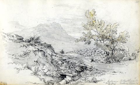 click to enlarge click to enlargeAS0164.jpg "between Tilberthwaite / & Fell foot. looking towards / Blea Tarn" item:- Armitt Library : 1958.487.64 Image © see bottom of page |
|||||||||||||||||||
|
|
||||||||||||||||||||
| evidence:- | old strip map:- Rumney 1899 |
|||||||||||||||||||
| source data:- | Road map, strip map, gradient diagram, and itinerary for Route VIII, Ambleside to
Langdale, Dungeon Ghyll, Westmorland, scale about 2 miles to 1 inch, by A W Rumney,
published by George Philip and Son, 32 Fleet Street, London, and Liverpool, 1899.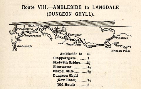 click to enlarge click to enlargeRUM110.jpg On p.33 of the Cyclist's Guide to the English Lake District, by A W Rumney. printed at top:- "Route VIII. - AMBLESIDE TO LANGDALE / (DUNGEON GHYLL)" item:- JandMN : 147.11 Image © see bottom of page |
|||||||||||||||||||
|
|
||||||||||||||||||||
| places:- | Clappersgate, Lakes Chapel Stile, Lakes Little Langdale, Lakes |
|||||||||||||||||||
|
|
||||||||||||||||||||
Lakes Guides menu.