 Garnett 1850s-60s SD29


|

|
|
|
gazetteer links places may or may not be labelled on the map |
||

|
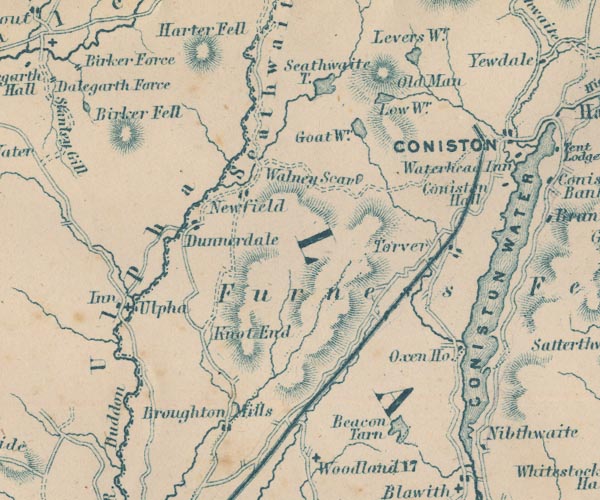
-- Beacon Tarn -- "Beacon Tarn" |
|
|
|
-- Birker Fell -- "Birker Fell" |
|
|
|
-- Blind Tarn |
|
|
|
-- Broughton Mills -- "Broughton Mills" |
|
|
|
-- Coniston Hall -- "Coniston Hall" |
|
|
|
-- Coniston Railway |
|
|
|
-- Coniston Water -- "CONISTON WATER" |
|
|
|
-- Duddon, River -- "R. Duddon" |
|
|
|
-- Dunnerdale -- "Ulpha" |
|
|
|
-- Furness Fells -- "Furness Fells" |
|
|
|
-- Goat's Water -- "Goat Wr." |
|
|
|
-- Hall Dunnerdale -- "Dunnerdale" |
|
|
|
-- High Nibthwaite -- "Nibthwaite" |
|
|
|
-- Plough -- "Inn" |
|
|
|
-- Levers Water -- "Levers Wr." |
|
|
|
-- Low Water -- "Low Wr." |
|
|
|
-- Old Man of Coniston, The -- "Old Man" |
|
|
|
-- Oxen House -- "Oxen Ho." |
|
|
|
-- Seathwaite Fells -- "Seathwaite" |
|
|
|
-- Seathwaite Tarn -- "Seathwaite T." |
|
|
|
-- St John's Church |
|
|
|
-- Torver -- "Torver" |
|
|
|
-- Ulpha -- "Ulpha" |
|
|
|
-- Walna Scar -- "Walney Scar" |
|
|
civil parishes The area roughly includes parts of parishes:- Blawith and Subberthwaite Torver Coniston Kirkby Ireleth Dunnerdale-with-Seathwaite Ulpha Colton Broughton West Eskdale |
||
|
|
||
|
|
Lakes Guides menu. | |