 Old Cumbria Gazetteer
 |
 |
|
||||||||||||||||||||||||||||||||||||||||||||||||||||||||||||||||||||||||||||||||
| Old Man of Coniston, Coniston | ||||||||||||||||||||||||||||||||||||||||||||||||||||||||||||||||||||||||||||||||||
| Coniston Old Man | ||||||||||||||||||||||||||||||||||||||||||||||||||||||||||||||||||||||||||||||||||
| locality:- | Coniston Fells | |||||||||||||||||||||||||||||||||||||||||||||||||||||||||||||||||||||||||||||||||
| civil parish:- | Coniston (formerly Lancashire) | |||||||||||||||||||||||||||||||||||||||||||||||||||||||||||||||||||||||||||||||||
| county:- | Cumbria | |||||||||||||||||||||||||||||||||||||||||||||||||||||||||||||||||||||||||||||||||
| locality type:- | hill | |||||||||||||||||||||||||||||||||||||||||||||||||||||||||||||||||||||||||||||||||
| coordinates:- | SD27239782 | |||||||||||||||||||||||||||||||||||||||||||||||||||||||||||||||||||||||||||||||||
| 1Km square:- | SD2797 | |||||||||||||||||||||||||||||||||||||||||||||||||||||||||||||||||||||||||||||||||
| 10Km square:- | SD29 | |||||||||||||||||||||||||||||||||||||||||||||||||||||||||||||||||||||||||||||||||
| altitude:- | 2628 feet | |||||||||||||||||||||||||||||||||||||||||||||||||||||||||||||||||||||||||||||||||
| altitude:- | 801m | |||||||||||||||||||||||||||||||||||||||||||||||||||||||||||||||||||||||||||||||||
|
|
||||||||||||||||||||||||||||||||||||||||||||||||||||||||||||||||||||||||||||||||||
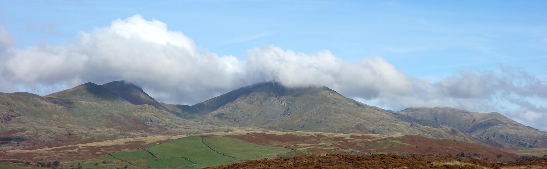
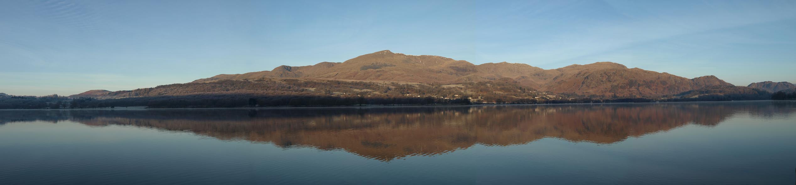 Click to enlarge BTX55.jpg (taken 21.1.2011) 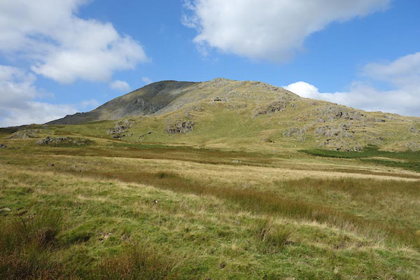 CBP38.jpg From S. (taken 2.9.2014) |
||||||||||||||||||||||||||||||||||||||||||||||||||||||||||||||||||||||||||||||||||
|
|
||||||||||||||||||||||||||||||||||||||||||||||||||||||||||||||||||||||||||||||||||
| evidence:- | descriptive text:- West 1778 (11th edn 1821) placename:- Coniston Old Man |
|||||||||||||||||||||||||||||||||||||||||||||||||||||||||||||||||||||||||||||||||
| source data:- | Guide book, A Guide to the Lakes, by Thomas West, published by
William Pennington, Kendal, Cumbria once Westmorland, and in
London, 1778 to 1821. goto source goto sourcePage 190:- "A TABLE OF THE Height of Mountains and Lakes SEEN IN THIS TOUR, ... TAKEN FROM THE LEVEL OF THE SEA. ... by Mr. John Dalton." "Coniston Old-man ... 860 [yards]" |
|||||||||||||||||||||||||||||||||||||||||||||||||||||||||||||||||||||||||||||||||
|
|
||||||||||||||||||||||||||||||||||||||||||||||||||||||||||||||||||||||||||||||||||
| evidence:- | old text:- Green 1810 placename:- Man mountain placename:- Old Man, The |
|||||||||||||||||||||||||||||||||||||||||||||||||||||||||||||||||||||||||||||||||
| source data:- | Set of prints, soft ground etchings, Sixty Studies from Nature,
by William Green, Ambleside, Westmorland, drawn 1808-10,
published 1810. goto source page 2:- "..." "The view here presented is a mile from the foot of the lake, and is of the Man mountain, or, as it is more frequently called, the Old Man, with the pointed summit of Enfoot on the right, and Dove Crag on the left, a range of line probably more picturesque ..." |
|||||||||||||||||||||||||||||||||||||||||||||||||||||||||||||||||||||||||||||||||
|
|
||||||||||||||||||||||||||||||||||||||||||||||||||||||||||||||||||||||||||||||||||
| evidence:- | old print:- Green 1814 (plate 2) item:- cattle |
|||||||||||||||||||||||||||||||||||||||||||||||||||||||||||||||||||||||||||||||||
| source data:- | Print, tinted soft ground etching, Coniston Water Head, Coniston, Lancashire, by William
Green, Ambleside, Westmorland, 1814.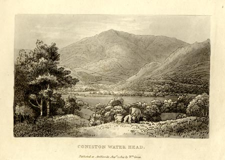 click to enlarge click to enlargeGN1002.jpg Plate 2 in Sixty Small Prints. printed at top right:- "2" printed at bottom:- "CONISTON WATER HEAD. / Published at Ambleside Augst. 1, 1814, by Wm. Green." item:- Armitt Library : A6653.2 Image © see bottom of page |
|||||||||||||||||||||||||||||||||||||||||||||||||||||||||||||||||||||||||||||||||
|
|
||||||||||||||||||||||||||||||||||||||||||||||||||||||||||||||||||||||||||||||||||
| evidence:- | old print:- Green 1814 (plate 2) item:- cattle |
|||||||||||||||||||||||||||||||||||||||||||||||||||||||||||||||||||||||||||||||||
| source data:- | Print, uncoloured soft ground etching, Coniston Water Head, Coniston, Lancashire,
by William Green, Ambleside, Westmorland, 1814.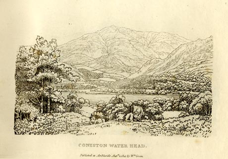 click to enlarge click to enlargeGN0902.jpg Plate 2 in Sixty Small Prints. printed at top right:- "2" printed at bottom:- "CONISTON WATER HEAD. / Published at Ambleside Augst. 1, 1814, by Wm. Green." item:- Armitt Library : A6656.2 Image © see bottom of page |
|||||||||||||||||||||||||||||||||||||||||||||||||||||||||||||||||||||||||||||||||
|
|
||||||||||||||||||||||||||||||||||||||||||||||||||||||||||||||||||||||||||||||||||
| evidence:- | old print:- Green 1814 (plate 1) |
|||||||||||||||||||||||||||||||||||||||||||||||||||||||||||||||||||||||||||||||||
| source data:- | Print, tinted soft ground etching, Coniston Water, Coniston, Lancashire, by William
Green, Ambleside, Westmorland, 1814.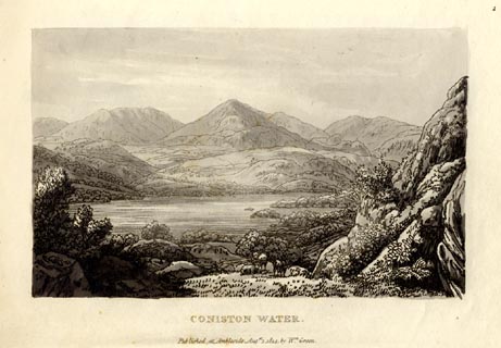 click to enlarge click to enlargeGN1001.jpg Plate 1 in Sixty Small Prints. printed at top right:- "1" printed at bottom:- "CONISTON WATER. / Published at Ambleside Augst. 1, 1814, by Wm. Green." item:- Armitt Library : A6653.1 Image © see bottom of page |
|||||||||||||||||||||||||||||||||||||||||||||||||||||||||||||||||||||||||||||||||
|
|
||||||||||||||||||||||||||||||||||||||||||||||||||||||||||||||||||||||||||||||||||
| evidence:- | old print:- Green 1814 (plate 1) |
|||||||||||||||||||||||||||||||||||||||||||||||||||||||||||||||||||||||||||||||||
| source data:- | Print, uncoloured soft ground etching, Coniston Water, Coniston, Lancashire, by William
Green, Ambleside, Westmorland, 1814.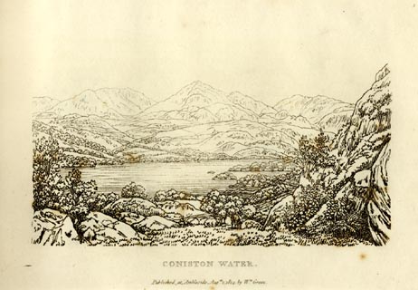 click to enlarge click to enlargeGN0901.jpg Plate 1 in Sixty Small Prints. printed at top right:- "1" printed at bottom:- "CONISTON WATER. / Published at Ambleside Augst. 1, 1814, by Wm. Green." item:- Armitt Library : A6656.1 Image © see bottom of page |
|||||||||||||||||||||||||||||||||||||||||||||||||||||||||||||||||||||||||||||||||
|
|
||||||||||||||||||||||||||||||||||||||||||||||||||||||||||||||||||||||||||||||||||
| evidence:- | old text:- Green 1814 placename:- Man, The placename:- Old Man |
|||||||||||||||||||||||||||||||||||||||||||||||||||||||||||||||||||||||||||||||||
| source data:- | Set of prints, soft ground etchings, Sixty Small Prints, with
text, A Description of a Series of Sixty Small Prints, by
William Green, Ambleside, Westmorland, 1814. goto source page 4:- "... The first view after leaving Nibthwaite is of "the Man," a mountain somewhat conical, and of other summits scarcely inferior in height." "The view here presented [plate 1] is a mile from the foot of the lake, and is of the Man mountain,or, as it is more frequently called, the "Old Man," with the pointed summit of Enfoot on the right, and Dove Crag on the left - a range of line probably more picturesque than is exhibited by these mountains on any other stand ..." |
|||||||||||||||||||||||||||||||||||||||||||||||||||||||||||||||||||||||||||||||||
|
|
||||||||||||||||||||||||||||||||||||||||||||||||||||||||||||||||||||||||||||||||||
| evidence:- | old print:- Green 1815 placename:- Man Mountain on Coniston item:- clouds |
|||||||||||||||||||||||||||||||||||||||||||||||||||||||||||||||||||||||||||||||||
| source data:- | Print, coloured aquatint, Man Mountain on Coniston Water, Coniston, Lancashire, by
William Green, Ambleside, Westmorland, 1815.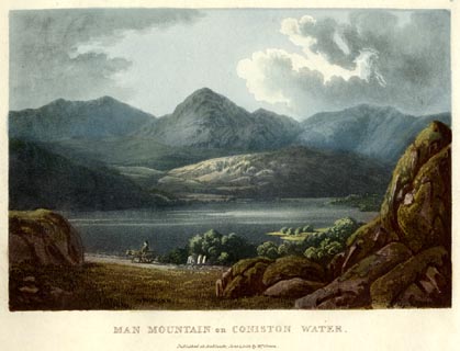 click to enlarge click to enlargeGN0503.jpg Plate 3 in Lake Scenery. printed at upper right:- "3" printed at bottom:- "MAN MOUNTAIN on CONISTON WATER. / Published at Ambleside, June 1, 1815, by Wm. Green." item:- Armitt Library : A6646.3 Image © see bottom of page |
|||||||||||||||||||||||||||||||||||||||||||||||||||||||||||||||||||||||||||||||||
|
|
||||||||||||||||||||||||||||||||||||||||||||||||||||||||||||||||||||||||||||||||||
| evidence:- | old map:- Otley 1818 placename:- Old Man |
|||||||||||||||||||||||||||||||||||||||||||||||||||||||||||||||||||||||||||||||||
| source data:- | Map, uncoloured engraving, The District of the Lakes,
Cumberland, Westmorland, and Lancashire, scale about 4 miles to
1 inch, by Jonathan Otley, 1818, engraved by J and G Menzies,
Edinburgh, Scotland, published by Jonathan Otley, Keswick,
Cumberland, et al, 1833. OT02SD29.jpg item:- JandMN : 48.1 Image © see bottom of page |
|||||||||||||||||||||||||||||||||||||||||||||||||||||||||||||||||||||||||||||||||
|
|
||||||||||||||||||||||||||||||||||||||||||||||||||||||||||||||||||||||||||||||||||
| evidence:- | outline view:- Otley 1823 (8th edn 1849) placename:- Old Man |
|||||||||||||||||||||||||||||||||||||||||||||||||||||||||||||||||||||||||||||||||
| source data:- | Engraving, outline view of mountains, Windermere looking towards the West from the
Road between Troutbeck and Bowness, drawn by T Binns, engraved by O Jewitt, opposite
p.4 of A Descriptive Guide of the English Lakes, by Jonathan Otley, 8th edition, 1849.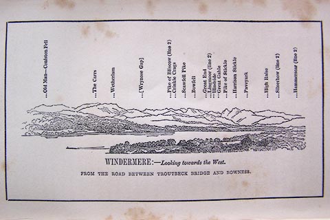 click to enlarge click to enlargeO80E03.jpg item:- Armitt Library : A1180.4 Image © see bottom of page |
|||||||||||||||||||||||||||||||||||||||||||||||||||||||||||||||||||||||||||||||||
|
|
||||||||||||||||||||||||||||||||||||||||||||||||||||||||||||||||||||||||||||||||||
| evidence:- | outline view:- Otley 1823 (8th edn 1849) placename:- Old Man |
|||||||||||||||||||||||||||||||||||||||||||||||||||||||||||||||||||||||||||||||||
| source data:- | Engraving, outline view of mountains, Coniston Water from near Bank Ground, drawn
by T Binns, engraved by O Jewitt, opposite p.8 of A Descriptive Guide of the English
Lakes, by Jonathan Otley, 8th edition, 1849.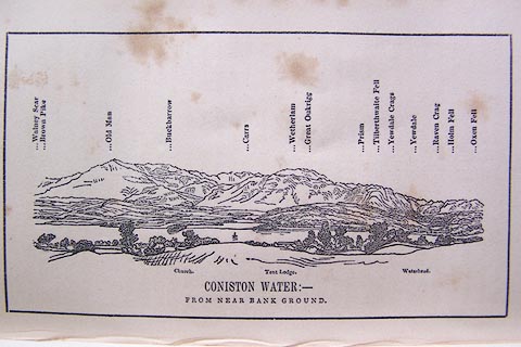 click to enlarge click to enlargeO80E05.jpg item:- Armitt Library : A1180.6 Image © see bottom of page |
|||||||||||||||||||||||||||||||||||||||||||||||||||||||||||||||||||||||||||||||||
|
|
||||||||||||||||||||||||||||||||||||||||||||||||||||||||||||||||||||||||||||||||||
| evidence:- | outline view:- Otley 1823 (8th edn 1849) placename:- Old Man |
|||||||||||||||||||||||||||||||||||||||||||||||||||||||||||||||||||||||||||||||||
| source data:- | Engraving, outline view of mountains, A Group of Mountains seen from Helvellyn, looking
towards the South West, drawn by T Binns, engraved by O Jewitt, opposite p.50 of A
Descriptive Guide of the English Lakes, by Jonathan Otley, 8th edition, 1849.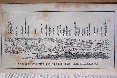 click to enlarge click to enlargeO80E17.jpg item:- Armitt Library : A1180.18 Image © see bottom of page |
|||||||||||||||||||||||||||||||||||||||||||||||||||||||||||||||||||||||||||||||||
|
|
||||||||||||||||||||||||||||||||||||||||||||||||||||||||||||||||||||||||||||||||||
| evidence:- | old text:- Otley 1823 (5th edn 1834) item:- bearings |
|||||||||||||||||||||||||||||||||||||||||||||||||||||||||||||||||||||||||||||||||
| source data:- | Guide book, A Concise Description of the English Lakes, the
mountains in their vicinity, and the roads by which they may be
visited, with remarks on the mineralogy and geology of the
district, by Jonathan Otley, published by the author, Keswick,
Cumberland now Cumbria, by J Richardson, London, and by Arthur
Foster, Kirkby Lonsdale, Cumbria, 1823; published 1823-49,
latterly as the Descriptive Guide to the English Lakes. goto source Page 79:- "STATION IV.- CONISTON OLD MAN." Latitude 54° 22′ 20″ N. Longitude 3° 6′ 34″W. Height 2577 feet.
|
|||||||||||||||||||||||||||||||||||||||||||||||||||||||||||||||||||||||||||||||||
|
|
||||||||||||||||||||||||||||||||||||||||||||||||||||||||||||||||||||||||||||||||||
| evidence:- | outline view:- Otley 1823 (4th edn 1830) placename:- Old Man - Coniston Fell |
|||||||||||||||||||||||||||||||||||||||||||||||||||||||||||||||||||||||||||||||||
| source data:- | Print, engraving, outline view, Some of the Western Mountains as seen from Helvellyn,
published by Jonathan Otley, Keswick, Cumberland et al, 1830.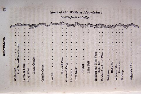 click to enlarge click to enlargeO75E02.jpg p.57 in A Concise Description of the English Lakes, by Jonathan Otley, 4th edition, 1830. "Some of the Western Mountains: / as seen from Helvellyn." "Wetherlam / Old Man - Coniston Fell / Carrs, or Scars / Gray Friar / Black Combe / Crinkle Crags / Bowfell / Scawfell Pike / Great-end Crag / Glaramara / Great Gable / Kirkfell / Pillar Fell / Honister and High Crag / High Stile / Dalehead and Red Pike / Robinson / Blake Fell / Witeless Pike / Grasmoor / Ill Crags / Grisedale Pike" item:- Armitt Library : A1175.3 Image © see bottom of page |
|||||||||||||||||||||||||||||||||||||||||||||||||||||||||||||||||||||||||||||||||
|
|
||||||||||||||||||||||||||||||||||||||||||||||||||||||||||||||||||||||||||||||||||
| evidence:- | outline view:- Otley 1823 (4th edn 1830) placename:- Old Man - Coniston Fell |
|||||||||||||||||||||||||||||||||||||||||||||||||||||||||||||||||||||||||||||||||
| source data:- | Print, engraving, outline view, Mountains of Coniston, Langdale, &c. as they appear
from the road between Troutbeck Bridge and Bowness, published by Jonathan Otley, Keswick,
Cumberland et al, 1830.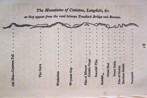 click to enlarge click to enlargeO75E04.jpg p.97 in A Concise Description of the English Lakes, by Jonathan Otley, 4th edition, 1830. "The Mountains of Coniston, Langdale, &c. / as they appear from the road between Troutbeck Bridge and Bowness." "Old Man - Coniston Fell / The Carrs / Wetherlam / Wrynose Gap / Pike of Bliscow / Crinkle Crags / Scawfell Pike / Bowfell / Great End / Great Gable / Pike of Stickle / Harrison Stickle / Paveyark" item:- Armitt Library : A1175.4 Image © see bottom of page |
|||||||||||||||||||||||||||||||||||||||||||||||||||||||||||||||||||||||||||||||||
|
|
||||||||||||||||||||||||||||||||||||||||||||||||||||||||||||||||||||||||||||||||||
| evidence:- | descriptive text:- Ford 1839 (3rd edn 1843) placename:- Coniston Old Man placename:- Old Man, The item:- cairn, Coniston; Old Man cairn; Old Man's Wife cairn; Old Man's Son cairn; altitude, Old Man of Coniston |
|||||||||||||||||||||||||||||||||||||||||||||||||||||||||||||||||||||||||||||||||
| source data:- | Guide book, A Description of Scenery in the Lake District, by
Rev William Ford, published by Charles Thurnam, Carlisle, by W
Edwards, 12 Ave Maria Lane, Charles Tilt, Fleet Street, William
Smith, 113 Fleet Street, London, by Currie and Bowman,
Newcastle, by Bancks and Co, Manchester, by Oliver and Boyd,
Edinburgh, and by Sinclair, Dumfries, 1839. goto source "... THE Lake district ... consists of large masses or clusters of mountains, generally terminating in one aspiring and pre-eminent point, with the intermediate valleys occupied either by lakes and their subsidiary tarns, or by winding rivers." "The chief nuclei of these clusters are, Skiddaw and Blencathra, Helvellyn, Fairfield, Coniston Old Man, Blackcomb, Scafell, Gable, Red Pike, Grasmoor, Grisdale Pike, and the Langdale Pikes. Many noble and commanding mountains rise around these, rivalling them in height and grandeur, but still" goto sourcePage iv:- "serving as large buttresses only. In the presentation of endlessly-diversified forms, these Mountains yield to none, however individually inferior they may be, owing to their being seldom seen in a detached point of view; although, on the other hand, they have thus the advantage of forming combinations at once grand and sublime, towering above each other, or rising in ridges, like the mighty billows of the ocean." goto sourcePage 10:- "[from the eastern side of Coniston Water] ... Peel island stretches boldly to the western shore, beyond which, are green fields, scattered woods and rocks, fishermen's cottages and farm-steads, and the awful Man-mountain rising over them, and shutting in the scene. ..." goto sourcePage 10:- "..." "ASCENT OF THE OLD MAN." "This almost peerless mountain rises majestically on the west side of the lake, having, at its base, the sweet village of Coniston, its groves and green fields. On one side the ascent is gradual from the base to the summit; on the other, a secondary mountain rises steep and rugged, its point heaped" goto sourcePage 11:- "into ridges and worn into furrows, forming a scene of wildness and grandeur. Between this and the Man-mountain, is a deep valley, from which the Old Man rises abruptly, and in some places perpendicularly. One half is covered with rocks and stones, the other with vegetation. The ascent is pleasant, safe, and comfortable. On the summit are three beacons of stone - the Old Man, his Wife, and Son. From it, there is a complete view of the fine bays and estuaries of the Lancashire, and part of the Cumberland coasts - the isles of Walney and Man - and in a very favourable state of the atmosphere, the Snowdonian range in Wales. The road may be traced from the top to Low Water, a tarn lying just beneath. Proceeding in a northerly direction under the summit of the Old Man, Levens Water is discovered, a tarn about a mile in circumference, open only towards the south, being enclosed in every other direction, and making a beautiful picture with part of Coniston Water, the hills about Nibthwaite, and beyond, a strip of sea reaching westward from the river Leven. The descent to Coniston, by the side of the stream flowing out of the tarn, is easy and picturesque." goto sourcePage 11:- "... On the summit [Old Man of Coniston] are three beacons of stone - the Old Man, his Wife, and Son. ..." goto sourcePage 178:- "ELEVATION OF THE MOUNTAINS," "ACCORDING TO DIFFERENT AUTHORITIES."
|
|||||||||||||||||||||||||||||||||||||||||||||||||||||||||||||||||||||||||||||||||
|
|
||||||||||||||||||||||||||||||||||||||||||||||||||||||||||||||||||||||||||||||||||
| evidence:- | old map:- Ford 1839 map placename:- Old Man |
|||||||||||||||||||||||||||||||||||||||||||||||||||||||||||||||||||||||||||||||||
| source data:- | Map, uncoloured engraving, Map of the Lake District of
Cumberland, Westmoreland and Lancashire, scale about 3.5 miles
to 1 inch, published by Charles Thurnam, Carlisle, and by R
Groombridge, 5 Paternoster Row, London, 3rd edn 1843. FD02SD29.jpg "Old Man" Hill hachuring. item:- JandMN : 100.1 Image © see bottom of page |
|||||||||||||||||||||||||||||||||||||||||||||||||||||||||||||||||||||||||||||||||
|
|
||||||||||||||||||||||||||||||||||||||||||||||||||||||||||||||||||||||||||||||||||
| evidence:- | old drawing:- Aspland 1840s-60s placename:- Coniston Old Man |
|||||||||||||||||||||||||||||||||||||||||||||||||||||||||||||||||||||||||||||||||
| source data:- | Drawing, pencil, Old Man of Coniston, Cumberland, by Theophilus Lindsey Aspland, 1847.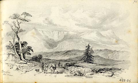 click to enlarge click to enlargeAS0285.jpg "Coniston / Old Man" page number "74" item:- Armitt Library : 1958.488.85 Image © see bottom of page |
|||||||||||||||||||||||||||||||||||||||||||||||||||||||||||||||||||||||||||||||||
|
|
||||||||||||||||||||||||||||||||||||||||||||||||||||||||||||||||||||||||||||||||||
| evidence:- | old drawing:- Aspland 1840s-60s |
|||||||||||||||||||||||||||||||||||||||||||||||||||||||||||||||||||||||||||||||||
| source data:- | Drawing, pencil, rocks on the Old Man of Coniston, Coniston, Lancashire, by Theophilus
Lindsey Aspland, 27 July 1852.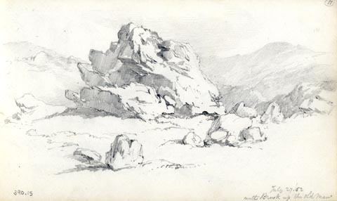 click to enlarge click to enlargeAS0315.jpg "July 27./52 / with Brook up the old Man" page number "(11)" item:- Armitt Library : 1958.390.15 Image © see bottom of page |
|||||||||||||||||||||||||||||||||||||||||||||||||||||||||||||||||||||||||||||||||
|
|
||||||||||||||||||||||||||||||||||||||||||||||||||||||||||||||||||||||||||||||||||
| evidence:- | old drawing:- Aspland 1840s-60s placename:- Old Man |
|||||||||||||||||||||||||||||||||||||||||||||||||||||||||||||||||||||||||||||||||
| source data:- | Drawing, pencil, Old Man of Coniston, Cumberland, by Theophilus Lindsey Aspland, 4
August 1849.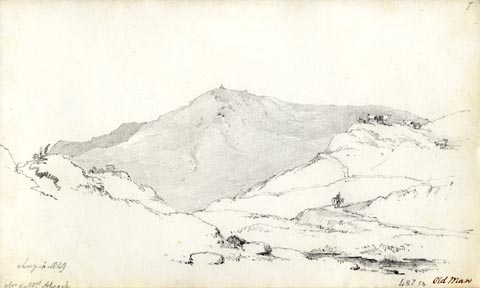 click to enlarge click to enlargeAS0110.jpg "Aug. 4. 1849 / Mr & Mrs. Alcock" "Old Man" item:- Armitt Library : 1958.487.10 Image © see bottom of page |
|||||||||||||||||||||||||||||||||||||||||||||||||||||||||||||||||||||||||||||||||
|
|
||||||||||||||||||||||||||||||||||||||||||||||||||||||||||||||||||||||||||||||||||
| evidence:- | old drawing:- Aspland 1840s-60s |
|||||||||||||||||||||||||||||||||||||||||||||||||||||||||||||||||||||||||||||||||
| source data:- | Drawing, pencil and ink wash, Coniston Water, Cumberland, by Theophilus Lindsey Aspland,
1849.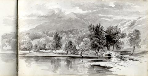 click to enlarge click to enlargeAS0176.jpg item:- Armitt Library : 1958.487.76 Image © see bottom of page |
|||||||||||||||||||||||||||||||||||||||||||||||||||||||||||||||||||||||||||||||||
|
|
||||||||||||||||||||||||||||||||||||||||||||||||||||||||||||||||||||||||||||||||||
| evidence:- | old map:- Garnett 1850s-60s H placename:- Old Man |
|||||||||||||||||||||||||||||||||||||||||||||||||||||||||||||||||||||||||||||||||
| source data:- | Map of the English Lakes, in Cumberland, Westmorland and
Lancashire, scale about 3.5 miles to 1 inch, published by John
Garnett, Windermere, Westmorland, 1850s-60s.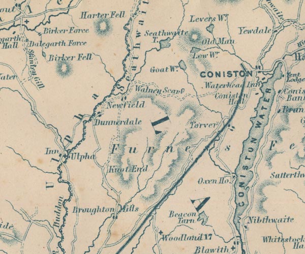 GAR2SD29.jpg "Old Man" hill hachuring item:- JandMN : 82.1 Image © see bottom of page |
|||||||||||||||||||||||||||||||||||||||||||||||||||||||||||||||||||||||||||||||||
|
|
||||||||||||||||||||||||||||||||||||||||||||||||||||||||||||||||||||||||||||||||||
| evidence:- | old print with text:- Pyne 1853 |
|||||||||||||||||||||||||||||||||||||||||||||||||||||||||||||||||||||||||||||||||
| source data:- | Print, tinted lithograph, Coniston Water, Cumberland, by James Baker Pyne, engraved
by W Gauci, published by Thomas Agnew and Sons, Manchester, Lancashire, 1853.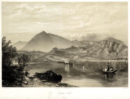 click to enlarge click to enlargePYN219.jpg "PAINTED BY J. B. PYNE. / W. GAUCI LITH. / MANCHESTER, PUBLISHED BY THOMAS AGNEW & SONS, 1853. / Coniston Water / M & N HANHART IMPT." From the descriptive text:- "The spectator here is supposed to be looking across the head of the Lake towards Coniston Old Man, a mountain so entitled from its resemblance to a human figure. ..." "... The geological character of the mountain is slate; for the excavation of which there are several large quarries, now for the most part abandoned. The produce of these quarries is usually conveyed down the Lake by means of boats, on their way to the port of Ulverston. Granite is to be found upon one part of the mountain, whilst around its sides and base, sienitic boulders are scattered in great numbers. A narrow bed of transition limestone strikes across the country at the foot of the mountain. The "Old Man" is rich in metal; several veins of copper intersecting its eastern side. The ore is drawn in pyrites from the mine, which is situated in a large cove half a mile up the hill, and extends for upwards of half a mile in a horizontal direction, the vertical shafts penetrating two hundred yards in depth. ..." item:- Armitt Library : A6678.20 Image © see bottom of page |
|||||||||||||||||||||||||||||||||||||||||||||||||||||||||||||||||||||||||||||||||
|
|
||||||||||||||||||||||||||||||||||||||||||||||||||||||||||||||||||||||||||||||||||
| evidence:- | old text:- Martineau 1855 item:- man; shelter; altitude, Old Man of Coniston; slate |
|||||||||||||||||||||||||||||||||||||||||||||||||||||||||||||||||||||||||||||||||
| source data:- | Guide book, A Complete Guide to the English Lakes, by Harriet
Martineau, published by John Garnett, Windermere, Westmorland,
and by Whittaker and Co, London, 1855; published 1855-76. goto source Page 27:- "... The Old Man, eleventh in height of the mountains of the district, (2,576 feet) towers above him; and the abodes of the people will shew him that he is in the neighbourhood of a copper mine. There is one, some way up the mountain; and he may see the winding road up to it. Higher up, where there is an evident hollow, he is told that he would find a deep black tarn; and higher up, another. But to climb the mountain is a day's work, with much doubt of success, (that is, of a clear summit,) and he must to-day be satisfied with what is below. ..." goto sourcePage 58:- "... He might go up the Old Man from Coniston; but there are the copper works, and there is the necessity of a guide: and it is a long way to go for the day's treat. ..." "..." goto sourcePage 168:- "... The summit is the edge of a line of rocks overhanging another tarn,- Low Water,- ... which is 2,000 feet above the sea level, while the summit of the Old Man is 2,632. On this rock, a "Man" formerly stood; but it was removed by the Ordnance Surveyors, who erected another, much inferior in convenience; for the first contained a chamber, welcome to shepherds and tourists overtaken by bad weather. The mountain consists chiefly of a very fine roofing slate, from which a large tract of country is supplied, and in which a very important trade was formerly carried on. Several of the quarries are now deserted. From the earliest recorded times, there have been works here for the extraction of copper; ..." goto sourcePage 169:- "... looking abroad from his perch, he sees, (beginning from Gait's Tarn) Devoke Water, in a line with Gait's Tarn, to the west. ... There is a fine stretch of sea visible, with the Isle of Man, conspicuous in good weather. We need not recapitulate the names of the chief mountains. Suffice it that Ingleborough is visible in one direction, and Lancaster Castle again in another; and in clear weather, Snowdon. The number of tarns within view is remarkable. We have mentioned Gait's Tarn and Low Water. Beyond the latter lies Seathwaite Tarn, whence the infant Duddon issues. Stickle Tarn is conspicuous, lying under Pavey Ark. In a hollow of the mountain, on its north-east side, lies Lowes Water. Only the nearer lakes are seen; but there is a glorious stretch of sea; and, when the estuaries are full, the coast is a beautiful spectacle. The shores of Coniston and Windermere, studded with woods and dwellings, are the nearer beauties." |
|||||||||||||||||||||||||||||||||||||||||||||||||||||||||||||||||||||||||||||||||
|
|
||||||||||||||||||||||||||||||||||||||||||||||||||||||||||||||||||||||||||||||||||
| evidence:- | old text:- Martineau 1855 placename:- Coniston Old Man item:- altitude, Old Man of Coniston |
|||||||||||||||||||||||||||||||||||||||||||||||||||||||||||||||||||||||||||||||||
| source data:- | Guide book, A Complete Guide to the English Lakes, by Harriet
Martineau, published by John Garnett, Windermere, Westmorland,
and by Whittaker and Co, London, 1855; published 1855-76. goto source Page 179:- "A TABLE OF THE HEIGHTS OF MOUNTAINS IN THE COUNTIES OF CUMBERLAND, WESTMORLAND, AND LANCASHIRE." "No. : Names of Mountains. : Counties. : Height in Feet above the Sea Level." "15 : Coniston Old Man : Lancashire : 2632" |
|||||||||||||||||||||||||||||||||||||||||||||||||||||||||||||||||||||||||||||||||
|
|
||||||||||||||||||||||||||||||||||||||||||||||||||||||||||||||||||||||||||||||||||
| evidence:- | outline view:- Martineau 1855 placename:- Coniston Old Man item:- altitude, Old Man of Coniston |
|||||||||||||||||||||||||||||||||||||||||||||||||||||||||||||||||||||||||||||||||
| source data:- | Print, engraving, outline view, Mountains on the West Side of Windermere, drawn by
L Aspland, engraved by W Banks, Edinburgh, published by John Garnett, Windermere,
Westmorland, and by Whittaker and Co, London, 1855.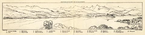 click to enlarge click to enlargeMNU102.jpg Folded in opposite p.7 in A Complete Guide to the English Lakes, by Harriet Martineau. "MOUNTAINS ON THE WEST SIDE OF WINDERMERE" "L Aspland Delt. / W Banks Sc Edinburgh." The view is captioned, numbers referring to mountains in the image:- "1 Coniston Old Man 1a Carrs 2 Wetherlam 3 Wrynose Gap 4 Crinkle Crags 5 Pike of Bliscow 6 Scawfell Pike 7 Bowfell 8 Hanging Knotts 9 Glaramara 10 Great End 11 Pike of Stickle 12 Harrison Stickle 13 Paveyark 14 Lingmoor 15 High Raise 16 Silver How 17 Loughrigg Fell 18 Ullscarth" item:- Armitt Library : A1159.2 Image © see bottom of page |
|||||||||||||||||||||||||||||||||||||||||||||||||||||||||||||||||||||||||||||||||
|
|
||||||||||||||||||||||||||||||||||||||||||||||||||||||||||||||||||||||||||||||||||
| evidence:- | old print:- Payn 1867 |
|||||||||||||||||||||||||||||||||||||||||||||||||||||||||||||||||||||||||||||||||
| source data:- | Print, uncoloured engraving, Coniston Lake, from the East, Coniston, Lancashire, by
T L Aspland, engraved by J Cooper, published by J Garnett, Windermere, Westmorland,
1867.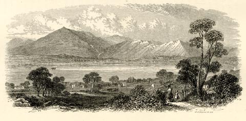 click to enlarge click to enlargePN0331.jpg On p.64 of The Lakes in Sunshine, text by James Payn. printed at lower right:- "J. COOPER SC" item:- Fell and Rock Climbing Club : 184.31 Image © see bottom of page |
|||||||||||||||||||||||||||||||||||||||||||||||||||||||||||||||||||||||||||||||||
|
|
||||||||||||||||||||||||||||||||||||||||||||||||||||||||||||||||||||||||||||||||||
| evidence:- | old print:- Walton 1876 placename:- Old Man, The |
|||||||||||||||||||||||||||||||||||||||||||||||||||||||||||||||||||||||||||||||||
| source data:- | Print, colour lithograph, The Old Man, Coniston, Lancashire, from a painting by Elijah
Walton, published by W M Thompson, 20 Cockspur Street, Pall Mall, and Burlington Gallery,
Piccadilly, London, 1876.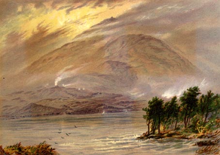 click to enlarge click to enlargeWLT312.jpg Plate 12 in English Lake Scenery, with a description by T G Bonney. item:- JandMN : 469.12 Image © see bottom of page |
|||||||||||||||||||||||||||||||||||||||||||||||||||||||||||||||||||||||||||||||||
|
|
||||||||||||||||||||||||||||||||||||||||||||||||||||||||||||||||||||||||||||||||||
| evidence:- | illustration:- LNWR 1910 |
|||||||||||||||||||||||||||||||||||||||||||||||||||||||||||||||||||||||||||||||||
| source data:- | Print, colour lithograph? Coniston Old Man, from Orrest Head,
from a painting by R T Roussel, published by the London and
North Western Railway, LNWR, about 1910.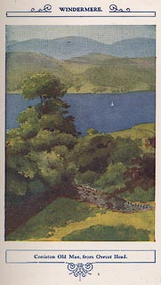 click to enlarge click to enlargeNW01E4.jpg Included in the guide book, The English Lakes, published by the London and North Western Railway about 1910. Roussel, R T, 1910item:- JandMN : 49.5 Image © see bottom of page |
|||||||||||||||||||||||||||||||||||||||||||||||||||||||||||||||||||||||||||||||||
|
|
||||||||||||||||||||||||||||||||||||||||||||||||||||||||||||||||||||||||||||||||||
| evidence:- | old map:- Postlethwaite 1877 (3rd edn 1913) placename:- Old Man |
|||||||||||||||||||||||||||||||||||||||||||||||||||||||||||||||||||||||||||||||||
| source data:- | Map, uncoloured engraving, Map of the Lake District Mining Field, Westmorland, Cumberland,
Lancashire, scale about 5 miles to 1 inch, by John Postlethwaite, published by W H
Moss and Sons, 13 Lowther Street, Whitehaven, Cumberland, 1877 edn 1913.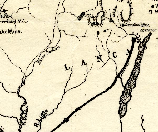 PST2SD29.jpg "OLD MAN" hill hachuring item:- JandMN : 162.2 Image © see bottom of page |
|||||||||||||||||||||||||||||||||||||||||||||||||||||||||||||||||||||||||||||||||
|
|
||||||||||||||||||||||||||||||||||||||||||||||||||||||||||||||||||||||||||||||||||
| evidence:- | old print:- Sylvan 1847 placename:- Coniston Old Man item:- packhorse (?) |
|||||||||||||||||||||||||||||||||||||||||||||||||||||||||||||||||||||||||||||||||
| source data:- | Print, engraving, Coniston Old Man, Lancashire, published by John Johnstone, Paternoster
Row, London, et al, 1847.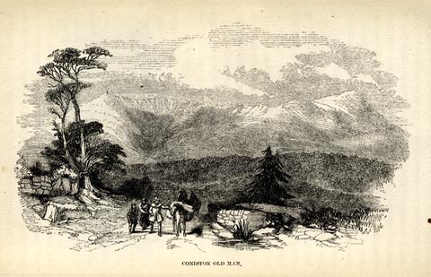 click to enlarge click to enlargeSYL129.jpg On p.95 of Sylvan's Pictorial Guide to the English Lakes. printed at bottom:- "CONISTON OLD MAN." item:- Armitt Library : A1201.29 Image © see bottom of page |
|||||||||||||||||||||||||||||||||||||||||||||||||||||||||||||||||||||||||||||||||
|
|
||||||||||||||||||||||||||||||||||||||||||||||||||||||||||||||||||||||||||||||||||
| evidence:- | outline view:- LMS 1920s |
|||||||||||||||||||||||||||||||||||||||||||||||||||||||||||||||||||||||||||||||||
| source data:- | Hills of Lakeland in Outline, published in the LMS Route Book No.3, The Track of the
Royal Scot, by the London, Midland and Scottish Railway, LMS, 1920s.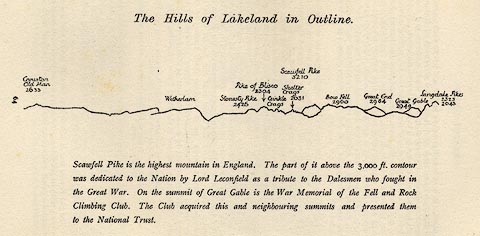 click to enlarge click to enlargeLS1E32.jpg item:- JandMN : 95.5 Image © see bottom of page |
|||||||||||||||||||||||||||||||||||||||||||||||||||||||||||||||||||||||||||||||||
|
|
||||||||||||||||||||||||||||||||||||||||||||||||||||||||||||||||||||||||||||||||||
| evidence:- | outline view:- Jenkinson 1875 placename:- Coniston Old Man |
|||||||||||||||||||||||||||||||||||||||||||||||||||||||||||||||||||||||||||||||||
| source data:- | Print, lithograph, outline view, Panoramic Sketches from Helvellyn, Westmorland, by
Edwin A Pettitt, London, published by Edward Stanford, 55 Charing Cross, London, 1875. click to enlarge click to enlargeJk01E1.jpg "... Coniston Old Man ..." item:- JandMN : 28.5 Image © see bottom of page |
|||||||||||||||||||||||||||||||||||||||||||||||||||||||||||||||||||||||||||||||||
|
|
||||||||||||||||||||||||||||||||||||||||||||||||||||||||||||||||||||||||||||||||||
| evidence:- | outline view:- Jenkinson 1875 placename:- Coniston Old Man |
|||||||||||||||||||||||||||||||||||||||||||||||||||||||||||||||||||||||||||||||||
| source data:- | Print, lithograph, outline view, Panoramic Sketches from Skiddaw, Cumberland, by Edwin
A Pettitt, London, published by Edward Stanford, 55 Charing Cross, London, 1875. click to enlarge click to enlargeJk01E2.jpg "... Coniston Old Man ..." item:- JandMN : 28.8 Image © see bottom of page |
|||||||||||||||||||||||||||||||||||||||||||||||||||||||||||||||||||||||||||||||||
|
|
||||||||||||||||||||||||||||||||||||||||||||||||||||||||||||||||||||||||||||||||||
| evidence:- | outline view:- Jenkinson 1875 placename:- Coniston Old Man |
|||||||||||||||||||||||||||||||||||||||||||||||||||||||||||||||||||||||||||||||||
| source data:- | Print, lithograph, outline view, Panoramic Sketches from Scawfell Pike, Cumberland,
by Edwin A Pettitt, London, published by Edward Stanford, 55 Charing Cross, London,
1875. click to enlarge click to enlargeJk01E3.jpg "... Coniston Old Man ..." item:- JandMN : 28.9 Image © see bottom of page |
|||||||||||||||||||||||||||||||||||||||||||||||||||||||||||||||||||||||||||||||||
|
|
||||||||||||||||||||||||||||||||||||||||||||||||||||||||||||||||||||||||||||||||||
| evidence:- | old print:- Waugh 1860 |
|||||||||||||||||||||||||||||||||||||||||||||||||||||||||||||||||||||||||||||||||
| source data:- | Print, engraving, Coniston Lake and Old Man, Coniston, Lancashire, drawn by T H Wilson,
published by Alexander Ireland and Co, 22 Market Street, Manchester, 1860.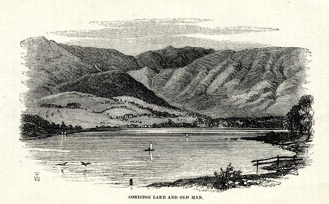 click to enlarge click to enlargeWU0116.jpg On p.44 of Over Sands to the Lakes, by Edwin Waugh. printed at bottom left:- "THW" printed at bottom:- "CONISTON LAKE AND OLD MAN." item:- Armitt Library : A1082.16 Image © see bottom of page |
|||||||||||||||||||||||||||||||||||||||||||||||||||||||||||||||||||||||||||||||||
|
|
||||||||||||||||||||||||||||||||||||||||||||||||||||||||||||||||||||||||||||||||||
| evidence:- | old print:- placename:- Coniston Old Man |
|||||||||||||||||||||||||||||||||||||||||||||||||||||||||||||||||||||||||||||||||
| source data:- | Print, uncoloured engraving, Coniston Old Man, Cumberland, engraved by Orrin Smith
and H Harral, published late 19th century?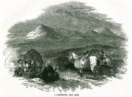 click to enlarge click to enlargePR0339.jpg On page 224 of The Land We Live In. In the foreground a family is gathering peats. printed at lower left:- "ORRIN SMITH &H HARRAL SC" printed at bottom:- "1.- CONISTON OLD MAN." item:- Dove Cottage : 2008.107.339 Image © see bottom of page |
|||||||||||||||||||||||||||||||||||||||||||||||||||||||||||||||||||||||||||||||||
|
|
||||||||||||||||||||||||||||||||||||||||||||||||||||||||||||||||||||||||||||||||||
| evidence:- | outline view:- Black 1856 (23rd edn 1900) placename:- Old Man |
|||||||||||||||||||||||||||||||||||||||||||||||||||||||||||||||||||||||||||||||||
| source data:- | Print, lithograph, Outline Views, Grasmere and Coniston - Mountains as seen from Redbank,
Grasmere, and Mountains as seen a little beyond Tent Lodge on the Road from Coniston
to Ulverstone, by J Flintoft, Keswick, Cumberland, engraved by R Mason, Edinburgh,
Lothian, about 1900.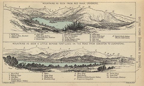 click to enlarge click to enlargeBC08E3.jpg "... 3 Old Man ..." item:- JandMN : 37.12 Image © see bottom of page |
|||||||||||||||||||||||||||||||||||||||||||||||||||||||||||||||||||||||||||||||||
|
|
||||||||||||||||||||||||||||||||||||||||||||||||||||||||||||||||||||||||||||||||||
| evidence:- | old print:- Pyne 1853 placename:- Coniston Old Man |
|||||||||||||||||||||||||||||||||||||||||||||||||||||||||||||||||||||||||||||||||
| source data:- | Coniston Water and Coniston Old Man drawn by James Barker Pyne, 1848-1853, lithographed
by T Picken, 1859.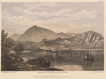 click to enlarge click to enlargePY02.jpg "Coniston Water and Coniston Old Man" item:- JandMN : 97.4 Image © see bottom of page |
|||||||||||||||||||||||||||||||||||||||||||||||||||||||||||||||||||||||||||||||||
|
|
||||||||||||||||||||||||||||||||||||||||||||||||||||||||||||||||||||||||||||||||||
| evidence:- | outline view:- Black 1841 (3rd edn 1846) placename:- Old Man |
|||||||||||||||||||||||||||||||||||||||||||||||||||||||||||||||||||||||||||||||||
| source data:- | Print, engraving, outline view, Mountains as seen from Red Bank, Grasmere, and Mountains
as seen a little beyond Tent-Lodge on the Road from Coniston to Ulverston, by J Flintoft,
Keswick, Cumberland, engraved by R Mason, Edinburgh, Lothian, about 1846.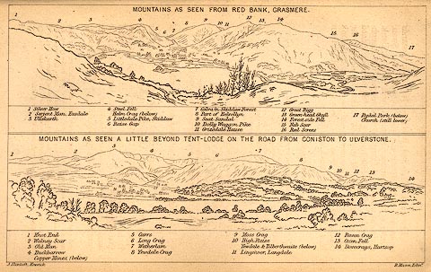 click to enlarge click to enlargeBC02E3.jpg "... 3 Old Man ..." item:- JandMN : 32.5 Image © see bottom of page |
|||||||||||||||||||||||||||||||||||||||||||||||||||||||||||||||||||||||||||||||||
|
|
||||||||||||||||||||||||||||||||||||||||||||||||||||||||||||||||||||||||||||||||||
| evidence:- | outline view:- Tattersall 1836 placename:- Coniston Old Man |
|||||||||||||||||||||||||||||||||||||||||||||||||||||||||||||||||||||||||||||||||
| source data:- | Print, engraving, Upper Reach, Coniston, Cumberland, drawn by George Tattersall, engraved
by W F Topham, published by Sherwood and Co, Paternoster Row, London, about 1836.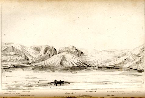 click to enlarge click to enlargeTAT106.jpg The print is captioned with mountain names and acts as an outline view. Tipped in opposite p.35 of The Lakes of England, by George Tattersall. printed at bottom:- "UPPER REACH, CONISTON." printed at bottom left to right:- "Coniston Old Man. / Undercrag. / Seathwaite Fells. / Coniston. / Oxenfell. / Wetherlam. / Waterhead. / Fairfield. / Hawkshead Moor. / Kirkstone. / How Head." item:- Armitt Library : A1204.7 Image © see bottom of page |
|||||||||||||||||||||||||||||||||||||||||||||||||||||||||||||||||||||||||||||||||
|
|
||||||||||||||||||||||||||||||||||||||||||||||||||||||||||||||||||||||||||||||||||
 ascent 1855 ascent 1855 |
||||||||||||||||||||||||||||||||||||||||||||||||||||||||||||||||||||||||||||||||||
|
|
||||||||||||||||||||||||||||||||||||||||||||||||||||||||||||||||||||||||||||||||||
 Click to enlarge CGU04.jpg (taken 18.10.2017) 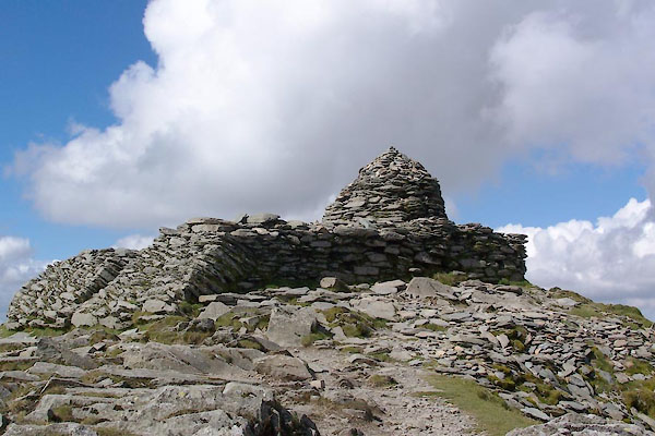 BTN46.jpg Cairn and shelter on a platform on the summit. (taken 8.9.2010) 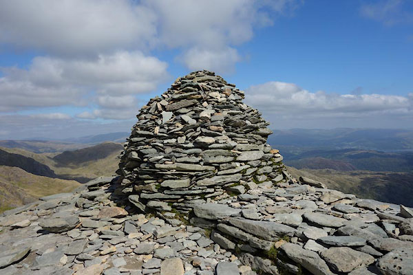 CBP10.jpg Cairn. (taken 2.9.2014) |
||||||||||||||||||||||||||||||||||||||||||||||||||||||||||||||||||||||||||||||||||
|
|
||||||||||||||||||||||||||||||||||||||||||||||||||||||||||||||||||||||||||||||||||
| hearsay:- |
Referred to as Kanchenjunga by Arthur Ransome. |
|||||||||||||||||||||||||||||||||||||||||||||||||||||||||||||||||||||||||||||||||
|
|
||||||||||||||||||||||||||||||||||||||||||||||||||||||||||||||||||||||||||||||||||
Lakes Guides menu.