 Old Cumbria Gazetteer
 |
 |
|
| Seathwaite Tarn, Dunnerdale-with-Seathwaite | ||
| runs into:- |  Tarn Beck Tarn Beck |
|
|
|
||
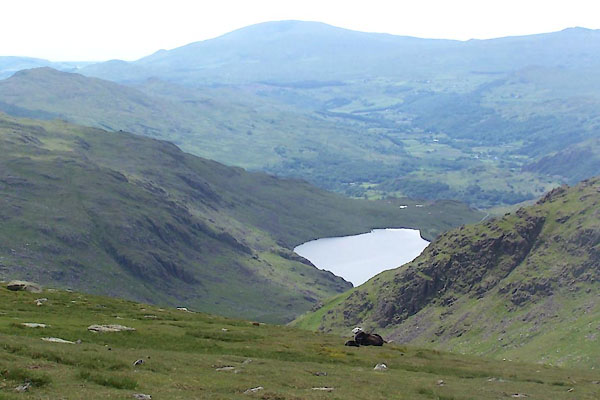
| Seathwaite Tarn | ||
| civil parish:- | Dunnerdale-with-Seathwaite (formerly Lancashire) | |
| county:- | Cumbria | |
| locality type:- | tarn | |
| coordinates:- | SD25309880 (etc) | |
| 1Km square:- | SD2598 | |
| 10Km square:- | SD29 | |
| altitude:- | 1214 feet | |
| altitude:- | 370m | |
|
|
||
 BWU68.jpg (taken 18.6.2012) 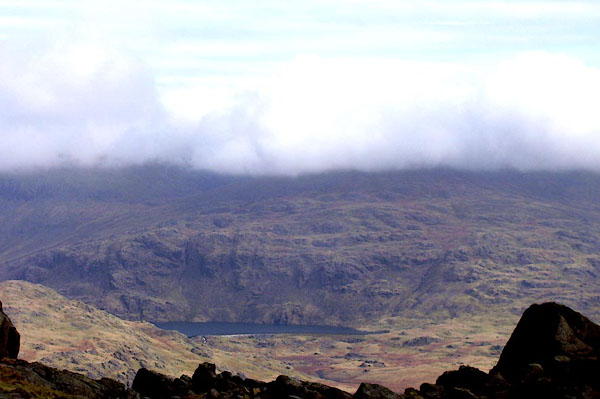 BNJ74.jpg (taken 14.3.2007) |
||
|
|
||
| evidence:- | old map:- Laurie and Whittle 1806 placename:- Saithwaite Tarn |
|
| source data:- | Road map, Completion of the Roads to the Lakes, scale about 10
miles to 1 inch, by Nathaniel Coltman? 1806, published by Robert
H Laurie, 53 Fleet Street, London, 1834. click to enlarge click to enlargeLw18.jpg "Saithwaite Tarn" lake item:- private collection : 18.18 Image © see bottom of page |
|
|
|
||
| evidence:- | old map:- Otley 1818 |
|
| source data:- | Map, uncoloured engraving, The District of the Lakes,
Cumberland, Westmorland, and Lancashire, scale about 4 miles to
1 inch, by Jonathan Otley, 1818, engraved by J and G Menzies,
Edinburgh, Scotland, published by Jonathan Otley, Keswick,
Cumberland, et al, 1833.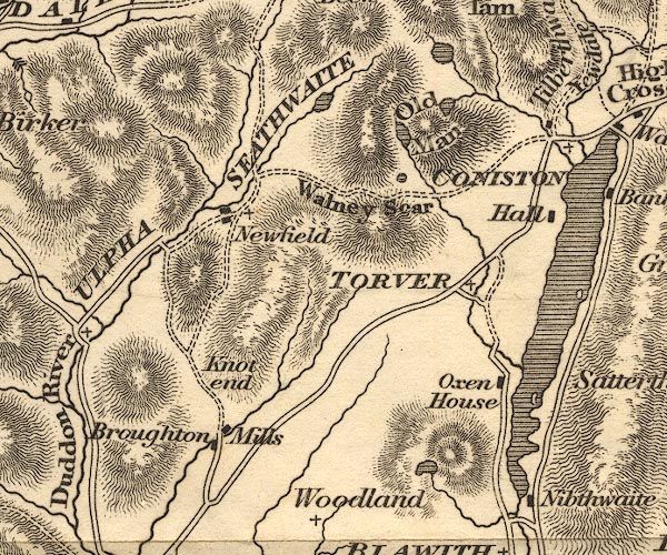 OT02SD29.jpg item:- JandMN : 48.1 Image © see bottom of page |
|
|
|
||
| evidence:- | descriptive text:- Otley 1823 (5th edn 1834) |
|
| source data:- | Guide book, A Concise Description of the English Lakes, the
mountains in their vicinity, and the roads by which they may be
visited, with remarks on the mineralogy and geology of the
district, by Jonathan Otley, published by the author, Keswick,
Cumberland now Cumbria, by J Richardson, London, and by Arthur
Foster, Kirkby Lonsdale, Cumbria, 1823; published 1823-49,
latterly as the Descriptive Guide to the English Lakes. goto source Page 36:- "Seathwaite Tarn empties itself into the river Duddon; it is separated from Levers Water, only by a narrow mountain ridge." |
|
|
|
||
| evidence:- | descriptive text:- Ford 1839 (3rd edn 1843) placename:- Seathwaite Tarn |
|
| source data:- | Guide book, A Description of Scenery in the Lake District, by
Rev William Ford, published by Charles Thurnam, Carlisle, by W
Edwards, 12 Ave Maria Lane, Charles Tilt, Fleet Street, William
Smith, 113 Fleet Street, London, by Currie and Bowman,
Newcastle, by Bancks and Co, Manchester, by Oliver and Boyd,
Edinburgh, and by Sinclair, Dumfries, 1839. goto source Page 12:- "..." "... The road to Seathwaite Tarn is over a pass, little inferior in height to the Man [Coniston]. This tarn contains on its northern side a rocky island, and Fairfield may be seen over its" goto sourcePage 13:- "surface, between side screens formed of rocky precipices. ..." |
|
|
|
||
| evidence:- | old map:- Garnett 1850s-60s H placename:- Seathwaite Tarn |
|
| source data:- | Map of the English Lakes, in Cumberland, Westmorland and
Lancashire, scale about 3.5 miles to 1 inch, published by John
Garnett, Windermere, Westmorland, 1850s-60s.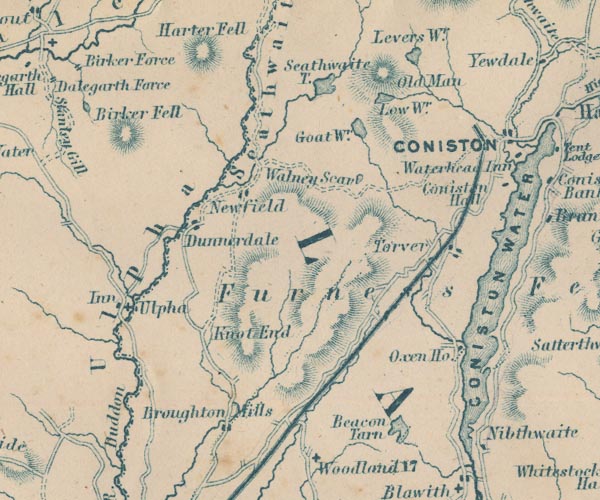 GAR2SD29.jpg "Seathwaite T." outline with shore form lines, lake or tarn item:- JandMN : 82.1 Image © see bottom of page |
|
|
|
||
| evidence:- | old print:- Heaton Cooper 1905 (edn 1908) placename:- Seathwaite Tarn |
|
| source data:- | Print, colour halftone, Seathwaite Tarn, Duddon Valley, Dunnerdale-with-Seathwaite,
Lancashire, from a watercolour painting by Alfred Heaton Cooper, published by Adam
and Charles Black, London, 2nd edn 1908.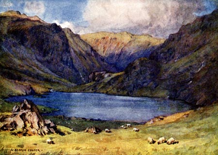 click to enlarge click to enlargeHC0175.jpg Opposite p.222 of The English Lakes, painted by Alfred Heaton Cooper, described by William T Palmer. printed at tissue opposite the print:- "SEATHWAITE TARN, DUDDON VALLEY" printed at signed lower left:- "A HEATON COOPER" item:- JandMN : 468.75 Image © see bottom of page |
|
|
|
||
| notes:- |
Supplies water to Barrow-in-Furness. |
|
|
|
||
Lakes Guides menu.