 Garnett 1850s-60s NY21


|

|
|
|
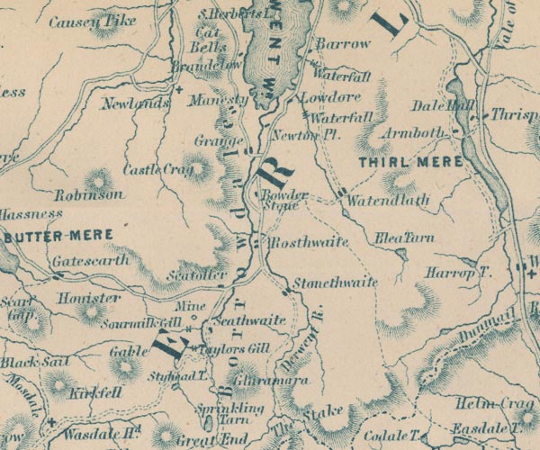
gazetteer links places may or may not be labelled on the map |
||

|
-- Barrow Cascade -- "Waterfall" |
|
|
|
-- Barrow House -- "Barrow" |
|
|
|
-- Borrowdale Graphite Mine (?) -- "Mine" |
|
|
|
-- Blea Tarn -- "Blea Tarn" |
|
|
|
-- Borrowdale -- "Borrowdale" |
|
|
|
-- Bowder Stone -- "Bowder Stone" |
|
|
|
-- Castle Crag -- "Castle Crag" |
|
|
|
-- Derwent Water -- "DERWENT WR." |
|
|
|
-- Derwent, River -- "Derwent R." -- "Derwent
R." -- "Derwent R." -- "Derwent R." |
|
|
|
-- Glaramara -- "Glaramara" |
|
|
|
-- Grange -- "Grange" |
|
|
|
-- Great Gable -- "Gable" |
|
|
|
-- Grisedale Tarn |
|
|
|
-- Honister Crag -- "Honister" |
|
|
|
-- Lodore Falls -- "Waterfall" |
|
|
|
-- Lodore -- "Lowdore" |
|
|
|
-- Manesty -- "Manesty" |
|
|
|
-- Newlands Church -- "Newlands" |
|
|
|
-- Old Brandelhow -- "Brandelow" |
|
|
|
-- Robinson -- "Robinson" |
|
|
|
-- Rosthwaite -- "Rosthwaite" |
|
|
|
-- Seatoller -- "Seatoller" |
|
|
|
-- Sour Milk Gill -- "Sourmilk Gill" |
|
|
|
-- Stonethwaite -- "Stonethwaite" |
|
|
|
-- Styhead Tarn -- "Styhead T." |
|
|
|
-- Taylorgill Force -- "Taylors Gill" |
|
|
|
-- Watendlath Tarn |
|
|
|
-- Watendlath -- "Watendlath" |
|
|
civil parishes The area roughly includes parts of parishes:- St John's Castlerigg and Wythburn Buttermere Borrowdale Above Derwent Nether Wasdale Keswick Ennerdale and Kinniside Lakes |
||
|
|
||
|
|
Lakes Guides menu. | |